Metselaar bart (22 resultados)

- Tapa blanda
Librería: Rarewaves USA, OSWEGO, IL, Estados Unidos de AmericaRarewaves USA
Contactar con el vendedorVendedor de 5 estrellasCondición: Nuevo
EUR 10,90
Gastos de envío gratisSe envía dentro de Estados Unidos de AmericaCantidad disponible: 2 disponibles
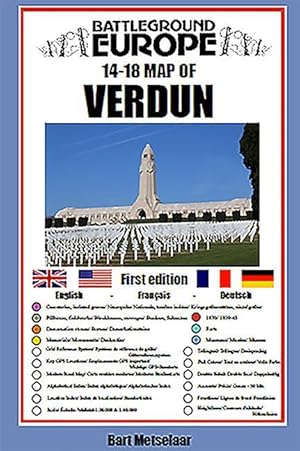
Paperback. Condición: New. For many years the Holts have provided tourers to the battlefields with excellent mapping for the Ypres Salient and the Somme. This map of the Verdun/Meuse area fills one of the many gaps in the coverage of the Western Front.This map of the Verdun battlefield is in the same style, using a colour coded…system to distinguish the different types of features. It includes some 300 locations of memorials, cemeteries, significant remnants of the battle terrain, remaining fortifications, trenches, the destroyed villages and other vestiges of the war. On the reverse there is a cut out and enlarged section of the Verdun battlefield in particular - the most visited part of the area, which provides greater detail. This section includes the Ossuary at Douamont, Forts Douamont, Vaux and Souville and many more features. The front line at key stages of the battle in 1916 is clearly indicatedGPS references are given for the more signifiant sites. Roads and major tracks are shown, with restrictions in access as known at the date of publication.The map extends from the eastern fringes of the Argonne Forest to the west and encompasses the whole of the 1916 Verdun battlefield to the east. This means that several places of interest to the student of the American army's offensive in late 1918 are shown.The map is tri-lingual - in English, French and German - so far as is practicable given the constraints of space. The map is of a manageable size, both in a vehicle and when being used outside.

- Tapa blanda
Librería: Grand Eagle Retail, Bensenville, IL, Estados Unidos de AmericaGrand Eagle Retail
Contactar con el vendedorVendedor de 5 estrellasCondición: Nuevo
EUR 11,75
Gastos de envío gratisSe envía dentro de Estados Unidos de AmericaCantidad disponible: 1 disponibles
Paperback. Condición: new. Paperback. For many years the Holts have provided tourers to the battlefields with excellent mapping for the Ypres Salient and the Somme. This map of the Verdun/Meuse area fills one of the many gaps in the coverage of the Western Front. This map of the Verdun battlefield is in the same style, using a c…olour coded system to distinguish the different types of features. It includes some 300 locations of memorials, cemeteries, significant remnants of the battle terrain, remaining fortifications, trenches, the destroyed villages and other vestiges of the war. On the reverse there is a cut out and enlarged section of the Verdun battlefield in particular - the most visited part of the area, which provides greater detail. This section includes the Ossuary at Douamont, Forts Douamont, Vaux and Souville and many more features. The front line at key stages of the battle in 1916 is clearly indicated GPS references are given for the more signifiant sites. Roads and major tracks are shown, with restrictions in access as known at the date of publication. The map extends from the eastern fringes of the Argonne Forest to the west and encompasses the whole of the 1916 Verdun battlefield to the east. This means that several places of interest to the student of the American army's offensive in late 1918 are shown. The map is tri-lingual - in English, French and German - so far as is practicable given the constraints of space. The map is of a manageable size, both in a vehicle and when being used outside. AUTHOR: Bart Metselaar has been visiting the battlefields of the Western Front for over twenty years, from his late teens. He has spent much time walking the battlefields of the Western Front and has acquired an encyclopaedic knowledge of the ground and the surviving remnants of the war. An amateur cartographer, he has produced the mapping for a number of Pen and Sword Battleground Europe books. He has been working on this Verdun map for some years, painstakingly searching out memorials that have been all but forgotten. He is now turning his attention to the Arras battlefield. 1 colour map Comprehensive mapping for the Battle of Verdun 1916 and a sizeable part of the early days of the Meuse-Argonne Offensive 1918. Clearly produced in full colour, with different types of feature in different colours, all supported by two comprehensive keys. Shipping may be from multiple locations in the US or from the UK, depending on stock availability.

- Tapa blanda
Librería: Rarewaves.com USA, London, LONDO, Reino UnidoRarewaves.com USA
Contactar con el vendedorVendedor de 5 estrellasCondición: Nuevo
EUR 12,05
Gastos de envío gratisSe envía de Reino Unido a Estados Unidos de AmericaCantidad disponible: 2 disponibles
Paperback. Condición: New. For many years the Holts have provided tourers to the battlefields with excellent mapping for the Ypres Salient and the Somme. This map of the Verdun/Meuse area fills one of the many gaps in the coverage of the Western Front.This map of the Verdun battlefield is in the same style, using a colour coded…system to distinguish the different types of features. It includes some 300 locations of memorials, cemeteries, significant remnants of the battle terrain, remaining fortifications, trenches, the destroyed villages and other vestiges of the war. On the reverse there is a cut out and enlarged section of the Verdun battlefield in particular - the most visited part of the area, which provides greater detail. This section includes the Ossuary at Douamont, Forts Douamont, Vaux and Souville and many more features. The front line at key stages of the battle in 1916 is clearly indicatedGPS references are given for the more signifiant sites. Roads and major tracks are shown, with restrictions in access as known at the date of publication.The map extends from the eastern fringes of the Argonne Forest to the west and encompasses the whole of the 1916 Verdun battlefield to the east. This means that several places of interest to the student of the American army's offensive in late 1918 are shown.The map is tri-lingual - in English, French and German - so far as is practicable given the constraints of space. The map is of a manageable size, both in a vehicle and when being used outside.

- Tapa blanda
Librería: Grand Eagle Retail, Bensenville, IL, Estados Unidos de AmericaGrand Eagle Retail
Contactar con el vendedorVendedor de 5 estrellasCondición: Nuevo
EUR 12,33
Gastos de envío gratisSe envía dentro de Estados Unidos de AmericaCantidad disponible: 1 disponibles
Paperback. Condición: new. Paperback. For many years the Holts have provided tourers to the battlefields with excellent practical mapping for the Ypres Salient and the Somme. This map of the Arras area, following the publication of Verdun in this series of Battleground Europe maps, fills one of the gaps in the coverage of the We…stern Front. This map of the Arras battlefield is in the same style, using a colour coded system to distinguish the different types of features. It includes over 200 locations of memorials, cemeteries, significant remnants of the battle terrain, remaining fortifications, trenches, and other vestiges of the war. It provides locations associated with many personalities, including VC winners and of the site of mine craters (some of which still exist) in the Vimy area. The front line at key stages of the war is clearly indicated GPS references are given for the more signifiant sites. Roads and major tracks are shown. High ground that was of importance in the fighting is clearly indicated. On the reverse there are enlarged sections of parts of the battlefield of notable importance, such as Notre Dame de Lorette, the northern end of Vimy Ridge (associated with the Canadian Corps) and the city of Arras. The map extends from just north of Notre Dame de Lorette to south of Bullecourt. To the east it includes, for example, Vis en Artois and Haucourt and to the west Ballacourt, Maroeuil and Mont St Eloi. The map is bi-lingual (in English and French) so far as is practicable and given the constraints of space. The map is of a manageable size, both in a vehicle and when being used outside on the ground. This is the second (following Verdun) of the maps that Bart has designed and produced of an important Great War conflict zone on the Western Front. Bart Metselaar has been visiting the battlefields of the Western Front for over twenty years, from his late teens. He has spent much time walking the battlefields of the Western Front and has acquired an encyclopaedic knowledge of the ground and the surviving remnants of the war. An amateur cartographer, he has produced the mapping for a number of Pen and Sword 'Battleground Europe' books. He worked on his first map, on the Verdun battlefield (2020) for some years, painstakingly searching out memorials that have been all but forgotten and working to design a map that could provide and place a wealth of information on the ground. He is now turning his attention to the French Flanders battlefield. 1 colour map Comprehensive mapping for the Battle of Arras 1917 and a sizeable part of the Battles of Artois 1914-1915. Shipping may be from multiple locations in the US or from the UK, depending on stock availability.

Librería: PBShop.store US, Wood Dale, IL, Estados Unidos de AmericaPBShop.store US
Contactar con el vendedorVendedor de 5 estrellasCondición: Nuevo
EUR 10,24
Gastos de envío gratisSe envía dentro de Estados Unidos de AmericaCantidad disponible: 3 disponibles
PAP. Condición: New. New Book. Shipped from UK. Established seller since 2000.
Librería: INDOO, Avenel, NJ, Estados Unidos de AmericaINDOO
Contactar con el vendedorVendedor de 5 estrellasCondición: Nuevo
EUR 12,07
Gastos de envío gratisSe envía dentro de Estados Unidos de AmericaCantidad disponible: Más de 20 disponibles
Condición: New. Brand New.
Librería: PBShop.store UK, Fairford, GLOS, Reino UnidoPBShop.store UK
Contactar con el vendedorVendedor de 5 estrellasCondición: Nuevo
EUR 10,07
Envío por EUR 3,81Se envía de Reino Unido a Estados Unidos de AmericaCantidad disponible: 3 disponibles
PAP. Condición: New. New Book. Shipped from UK. Established seller since 2000.
- Tapa blanda
Librería: Revaluation Books, Exeter, Reino UnidoRevaluation Books
Contactar con el vendedorVendedor de 5 estrellasCondición: Nuevo
EUR 9,16
Envío por EUR 14,48Se envía de Reino Unido a Estados Unidos de AmericaCantidad disponible: 2 disponibles
Paperback. Condición: Brand New. map edition. 8.39x5.59x0.08 inches. In Stock.
Librería: Majestic Books, Hounslow, Reino UnidoMajestic Books
Contactar con el vendedorVendedor de 4 estrellasCondición: Nuevo
EUR 10,89
Envío por EUR 7,53Se envía de Reino Unido a Estados Unidos de AmericaCantidad disponible: 3 disponibles
Condición: New.
Librería: Ria Christie Collections, Uxbridge, Reino UnidoRia Christie Collections
Contactar con el vendedorVendedor de 5 estrellasCondición: Nuevo
EUR 10,00
Envío por EUR 13,88Se envía de Reino Unido a Estados Unidos de AmericaCantidad disponible: 3 disponibles
Condición: New. In.
Librería: Kennys Bookshop and Art Galleries Ltd., Galway, GY, IrlandaKennys Bookshop and Art Galleries Ltd.
Contactar con el vendedorVendedor de 5 estrellasCondición: Nuevo
EUR 13,53
Envío por EUR 10,50Se envía de Irlanda a Estados Unidos de AmericaCantidad disponible: 3 disponibles
Condición: New. 2020. Map. . . . . .
Librería: Kennys Bookstore, Olney, MD, Estados Unidos de AmericaKennys Bookstore
Contactar con el vendedorVendedor de 5 estrellasCondición: Nuevo
EUR 16,01
Envío por EUR 9,22Se envía dentro de Estados Unidos de AmericaCantidad disponible: 3 disponibles
Condición: New. 2020. Map. . . . . . Books ship from the US and Ireland.
Librería: Biblios, frankfurt am main, HESSE, AlemaniaBiblios
Contactar con el vendedorVendedor de 4 estrellasCondición: Nuevo
EUR 16,84
Envío por EUR 9,95Se envía de Alemania a Estados Unidos de AmericaCantidad disponible: 3 disponibles
Condición: New.
- Tapa blanda
Librería: AussieBookSeller, Truganina, VIC, AustraliaAussieBookSeller
Contactar con el vendedorVendedor de 5 estrellasCondición: Nuevo
EUR 19,66
Envío por EUR 32,48Se envía de Australia a Estados Unidos de AmericaCantidad disponible: 1 disponibles
Paperback. Condición: new. Paperback. For many years the Holts have provided tourers to the battlefields with excellent practical mapping for the Ypres Salient and the Somme. This map of the Arras area, following the publication of Verdun in this series of Battleground Europe maps, fills one of the gaps in the coverage of the We…stern Front. This map of the Arras battlefield is in the same style, using a colour coded system to distinguish the different types of features. It includes over 200 locations of memorials, cemeteries, significant remnants of the battle terrain, remaining fortifications, trenches, and other vestiges of the war. It provides locations associated with many personalities, including VC winners and of the site of mine craters (some of which still exist) in the Vimy area. The front line at key stages of the war is clearly indicated GPS references are given for the more signifiant sites. Roads and major tracks are shown. High ground that was of importance in the fighting is clearly indicated. On the reverse there are enlarged sections of parts of the battlefield of notable importance, such as Notre Dame de Lorette, the northern end of Vimy Ridge (associated with the Canadian Corps) and the city of Arras. The map extends from just north of Notre Dame de Lorette to south of Bullecourt. To the east it includes, for example, Vis en Artois and Haucourt and to the west Ballacourt, Maroeuil and Mont St Eloi. The map is bi-lingual (in English and French) so far as is practicable and given the constraints of space. The map is of a manageable size, both in a vehicle and when being used outside on the ground. This is the second (following Verdun) of the maps that Bart has designed and produced of an important Great War conflict zone on the Western Front. Bart Metselaar has been visiting the battlefields of the Western Front for over twenty years, from his late teens. He has spent much time walking the battlefields of the Western Front and has acquired an encyclopaedic knowledge of the ground and the surviving remnants of the war. An amateur cartographer, he has produced the mapping for a number of Pen and Sword 'Battleground Europe' books. He worked on his first map, on the Verdun battlefield (2020) for some years, painstakingly searching out memorials that have been all but forgotten and working to design a map that could provide and place a wealth of information on the ground. He is now turning his attention to the French Flanders battlefield. 1 colour map Comprehensive mapping for the Battle of Arras 1917 and a sizeable part of the Battles of Artois 1914-1915. Shipping may be from our Sydney, NSW warehouse or from our UK or US warehouse, depending on stock availability.

- Tapa blanda
Librería: AussieBookSeller, Truganina, VIC, AustraliaAussieBookSeller
Contactar con el vendedorVendedor de 5 estrellasCondición: Nuevo
EUR 20,00
Envío por EUR 32,48Se envía de Australia a Estados Unidos de AmericaCantidad disponible: 1 disponibles
Paperback. Condición: new. Paperback. For many years the Holts have provided tourers to the battlefields with excellent mapping for the Ypres Salient and the Somme. This map of the Verdun/Meuse area fills one of the many gaps in the coverage of the Western Front. This map of the Verdun battlefield is in the same style, using a c…olour coded system to distinguish the different types of features. It includes some 300 locations of memorials, cemeteries, significant remnants of the battle terrain, remaining fortifications, trenches, the destroyed villages and other vestiges of the war. On the reverse there is a cut out and enlarged section of the Verdun battlefield in particular - the most visited part of the area, which provides greater detail. This section includes the Ossuary at Douamont, Forts Douamont, Vaux and Souville and many more features. The front line at key stages of the battle in 1916 is clearly indicated GPS references are given for the more signifiant sites. Roads and major tracks are shown, with restrictions in access as known at the date of publication. The map extends from the eastern fringes of the Argonne Forest to the west and encompasses the whole of the 1916 Verdun battlefield to the east. This means that several places of interest to the student of the American army's offensive in late 1918 are shown. The map is tri-lingual - in English, French and German - so far as is practicable given the constraints of space. The map is of a manageable size, both in a vehicle and when being used outside. AUTHOR: Bart Metselaar has been visiting the battlefields of the Western Front for over twenty years, from his late teens. He has spent much time walking the battlefields of the Western Front and has acquired an encyclopaedic knowledge of the ground and the surviving remnants of the war. An amateur cartographer, he has produced the mapping for a number of Pen and Sword Battleground Europe books. He has been working on this Verdun map for some years, painstakingly searching out memorials that have been all but forgotten. He is now turning his attention to the Arras battlefield. 1 colour map Comprehensive mapping for the Battle of Verdun 1916 and a sizeable part of the early days of the Meuse-Argonne Offensive 1918. Clearly produced in full colour, with different types of feature in different colours, all supported by two comprehensive keys. Shipping may be from our Sydney, NSW warehouse or from our UK or US warehouse, depending on stock availability.

- Tapa blanda
Librería: CitiRetail, Stevenage, Reino UnidoCitiRetail
Contactar con el vendedorVendedor de 5 estrellasCondición: Nuevo
EUR 11,32
Envío por EUR 42,87Se envía de Reino Unido a Estados Unidos de AmericaCantidad disponible: 1 disponibles
Paperback. Condición: new. Paperback. For many years the Holts have provided tourers to the battlefields with excellent mapping for the Ypres Salient and the Somme. This map of the Verdun/Meuse area fills one of the many gaps in the coverage of the Western Front. This map of the Verdun battlefield is in the same style, using a c…olour coded system to distinguish the different types of features. It includes some 300 locations of memorials, cemeteries, significant remnants of the battle terrain, remaining fortifications, trenches, the destroyed villages and other vestiges of the war. On the reverse there is a cut out and enlarged section of the Verdun battlefield in particular - the most visited part of the area, which provides greater detail. This section includes the Ossuary at Douamont, Forts Douamont, Vaux and Souville and many more features. The front line at key stages of the battle in 1916 is clearly indicated GPS references are given for the more signifiant sites. Roads and major tracks are shown, with restrictions in access as known at the date of publication. The map extends from the eastern fringes of the Argonne Forest to the west and encompasses the whole of the 1916 Verdun battlefield to the east. This means that several places of interest to the student of the American army's offensive in late 1918 are shown. The map is tri-lingual - in English, French and German - so far as is practicable given the constraints of space. The map is of a manageable size, both in a vehicle and when being used outside. AUTHOR: Bart Metselaar has been visiting the battlefields of the Western Front for over twenty years, from his late teens. He has spent much time walking the battlefields of the Western Front and has acquired an encyclopaedic knowledge of the ground and the surviving remnants of the war. An amateur cartographer, he has produced the mapping for a number of Pen and Sword Battleground Europe books. He has been working on this Verdun map for some years, painstakingly searching out memorials that have been all but forgotten. He is now turning his attention to the Arras battlefield. 1 colour map Comprehensive mapping for the Battle of Verdun 1916 and a sizeable part of the early days of the Meuse-Argonne Offensive 1918. Clearly produced in full colour, with different types of feature in different colours, all supported by two comprehensive keys. Shipping may be from our UK warehouse or from our Australian or US warehouses, depending on stock availability.

- Tapa blanda
Librería: Rarewaves USA United, OSWEGO, IL, Estados Unidos de AmericaRarewaves USA United
Contactar con el vendedorVendedor de 5 estrellasCondición: Nuevo
EUR 12,40
Envío por EUR 43,89Se envía dentro de Estados Unidos de AmericaCantidad disponible: 2 disponibles
Paperback. Condición: New. For many years the Holts have provided tourers to the battlefields with excellent mapping for the Ypres Salient and the Somme. This map of the Verdun/Meuse area fills one of the many gaps in the coverage of the Western Front.This map of the Verdun battlefield is in the same style, using a colour coded…system to distinguish the different types of features. It includes some 300 locations of memorials, cemeteries, significant remnants of the battle terrain, remaining fortifications, trenches, the destroyed villages and other vestiges of the war. On the reverse there is a cut out and enlarged section of the Verdun battlefield in particular - the most visited part of the area, which provides greater detail. This section includes the Ossuary at Douamont, Forts Douamont, Vaux and Souville and many more features. The front line at key stages of the battle in 1916 is clearly indicatedGPS references are given for the more signifiant sites. Roads and major tracks are shown, with restrictions in access as known at the date of publication.The map extends from the eastern fringes of the Argonne Forest to the west and encompasses the whole of the 1916 Verdun battlefield to the east. This means that several places of interest to the student of the American army's offensive in late 1918 are shown.The map is tri-lingual - in English, French and German - so far as is practicable given the constraints of space. The map is of a manageable size, both in a vehicle and when being used outside.
- Tapa blanda
Librería: CitiRetail, Stevenage, Reino UnidoCitiRetail
Contactar con el vendedorVendedor de 5 estrellasCondición: Nuevo
EUR 14,90
Envío por EUR 42,87Se envía de Reino Unido a Estados Unidos de AmericaCantidad disponible: 1 disponibles
Paperback. Condición: new. Paperback. For many years the Holts have provided tourers to the battlefields with excellent practical mapping for the Ypres Salient and the Somme. This map of the Arras area, following the publication of Verdun in this series of Battleground Europe maps, fills one of the gaps in the coverage of the We…stern Front. This map of the Arras battlefield is in the same style, using a colour coded system to distinguish the different types of features. It includes over 200 locations of memorials, cemeteries, significant remnants of the battle terrain, remaining fortifications, trenches, and other vestiges of the war. It provides locations associated with many personalities, including VC winners and of the site of mine craters (some of which still exist) in the Vimy area. The front line at key stages of the war is clearly indicated GPS references are given for the more signifiant sites. Roads and major tracks are shown. High ground that was of importance in the fighting is clearly indicated. On the reverse there are enlarged sections of parts of the battlefield of notable importance, such as Notre Dame de Lorette, the northern end of Vimy Ridge (associated with the Canadian Corps) and the city of Arras. The map extends from just north of Notre Dame de Lorette to south of Bullecourt. To the east it includes, for example, Vis en Artois and Haucourt and to the west Ballacourt, Maroeuil and Mont St Eloi. The map is bi-lingual (in English and French) so far as is practicable and given the constraints of space. The map is of a manageable size, both in a vehicle and when being used outside on the ground. This is the second (following Verdun) of the maps that Bart has designed and produced of an important Great War conflict zone on the Western Front. Bart Metselaar has been visiting the battlefields of the Western Front for over twenty years, from his late teens. He has spent much time walking the battlefields of the Western Front and has acquired an encyclopaedic knowledge of the ground and the surviving remnants of the war. An amateur cartographer, he has produced the mapping for a number of Pen and Sword 'Battleground Europe' books. He worked on his first map, on the Verdun battlefield (2020) for some years, painstakingly searching out memorials that have been all but forgotten and working to design a map that could provide and place a wealth of information on the ground. He is now turning his attention to the French Flanders battlefield. 1 colour map Comprehensive mapping for the Battle of Arras 1917 and a sizeable part of the Battles of Artois 1914-1915. Shipping may be from our UK warehouse or from our Australian or US warehouses, depending on stock availability.

- Tapa blanda
Librería: AHA-BUCH GmbH, Einbeck, AlemaniaAHA-BUCH GmbH
Contactar con el vendedorVendedor de 5 estrellasCondición: Nuevo
EUR 10,35
Envío por EUR 60,26Se envía de Alemania a Estados Unidos de AmericaCantidad disponible: 2 disponibles
Taschenbuch. Condición: Neu. Neuware - Comprehensive mapping for the Battle of Verdun 1916 and a sizable part of the early days of the Meuse-Argonne Offensive 1918. Clearly produced in full color, with different types of feature in different colors, all supported by two comprehensive keys.For many years the Holts have provided t…ourers to the battlefields with excellent mapping for the Ypres Salient and the Somme. This map of the Verdun/Meuse area fills one of the many gaps in the coverage of the Western Front.This map of the Verdun battlefield is in the same style, using a color coded system to distinguish the different types of features. It includes some 300 locations of memorials, cemeteries, significant remnants of the battle terrain, remaining fortifications, trenches, the destroyed villages and other vestiges of the war. On the reverse there is a cut out and enlarged section of the Verdun battlefield in particular - the most visited part of the area, which provides greater detail. This section includes the Ossuary at Douamont, Forts Douamont, Vaux and Souville and many more features. The front line at key stages of the battle in 1916 is clearly indicated.GPS references are given for the more significant sites. Roads and major tracks are shown, with restrictions in access as known at the date of publication.The map extends from the eastern fringes of the Argonne Forest to the west and encompasses the whole of the 1916 Verdun battlefield to the east. This means that several places of interest to the student of the American army's offensive in late 1918 are shown.The map is trilingual - in English, French and German - so far as is practicable given the constraints of space. The map is of a manageable size, both in a vehicle and when being used outside.

- Tapa blanda
Librería: Rarewaves.com UK, London, Reino UnidoRarewaves.com UK
Contactar con el vendedorVendedor de 5 estrellasCondición: Nuevo
EUR 8,97
Envío por EUR 75,31Se envía de Reino Unido a Estados Unidos de AmericaCantidad disponible: 2 disponibles
Paperback. Condición: New. For many years the Holts have provided tourers to the battlefields with excellent mapping for the Ypres Salient and the Somme. This map of the Verdun/Meuse area fills one of the many gaps in the coverage of the Western Front.This map of the Verdun battlefield is in the same style, using a colour coded…system to distinguish the different types of features. It includes some 300 locations of memorials, cemeteries, significant remnants of the battle terrain, remaining fortifications, trenches, the destroyed villages and other vestiges of the war. On the reverse there is a cut out and enlarged section of the Verdun battlefield in particular - the most visited part of the area, which provides greater detail. This section includes the Ossuary at Douamont, Forts Douamont, Vaux and Souville and many more features. The front line at key stages of the battle in 1916 is clearly indicatedGPS references are given for the more signifiant sites. Roads and major tracks are shown, with restrictions in access as known at the date of publication.The map extends from the eastern fringes of the Argonne Forest to the west and encompasses the whole of the 1916 Verdun battlefield to the east. This means that several places of interest to the student of the American army's offensive in late 1918 are shown.The map is tri-lingual - in English, French and German - so far as is practicable given the constraints of space. The map is of a manageable size, both in a vehicle and when being used outside.
Librería: moluna, Greven, Alemaniamoluna
Contactar con el vendedorVendedor de 5 estrellasCondición: Nuevo
EUR 12,95
Envío por EUR 48,99Se envía de Alemania a Estados Unidos de AmericaCantidad disponible: 3 disponibles
Condición: New. Comprehensive mapping for the Battle of Verdun 1916 and a sizeable part of the early days of the Meuse-Argonne Offensive 1918. Clearly produced in full colour, with different types of feature in different colours, all supported by two comprehensive keys.

- Mapa
Librería: preigu, Osnabrück, Alemaniapreigu
Contactar con el vendedorVendedor de 5 estrellasCondición: Nuevo
EUR 12,80
Envío por EUR 70,00Se envía de Alemania a Estados Unidos de AmericaCantidad disponible: 1 disponibles
(Land-)Karte. Condición: Neu. Verdun (Map) | Bart Metselaar | (Land-)Karte | Kartoniert / Broschiert | Englisch | 2020 | Pen & Sword Books | EAN 9781526768209 | Verantwortliche Person für die EU: Libri GmbH, Europaallee 1, 36244 Bad Hersfeld, gpsr[at]libri[dot]de | Anbieter: preigu.


