Petermann augustus (53 resultados)

- Tapa blanda
Librería: Ria Christie Collections, Uxbridge, Reino UnidoRia Christie Collections
Contactar con el vendedorVendedor de 5 estrellasCondición: Nuevo
EUR 22,89
Envío por EUR 13,99Se envía de Reino Unido a Estados Unidos de AmericaCantidad disponible: Más de 20 disponibles
Condición: New. In.

- Tapa dura
Librería: Ria Christie Collections, Uxbridge, Reino UnidoRia Christie Collections
Contactar con el vendedorVendedor de 5 estrellasCondición: Nuevo
EUR 33,67
Envío por EUR 13,99Se envía de Reino Unido a Estados Unidos de AmericaCantidad disponible: Más de 20 disponibles
Condición: New. In.
Editorial: Swanston, UK, 1846
- Tapa blanda
Librería: Maynard & Bradley, Leicester, Reino UnidoMaynard & Bradley
Contactar con el vendedorVendedor de 5 estrellasCondición: Usado - Bueno
EUR 19,19
Envío por EUR 25,63Se envía de Reino Unido a Estados Unidos de AmericaCantidad disponible: 1 disponibles
Softcover. Condición: Very Good. 1846. A very well-preserved engraving by Swanston, from Petermann c.1846. Faintly hand-coloured and overall very presentable, with the print itself remaining cleana nd clear across the entire image surface. the page bears a light damp mark at lower corner and some wear along right edge from remov…al from binding, not encroaching significantly on the print itself, would be easily concealed by a mount. Why on Amazon do most sellers not describe their actual book? Buy with confidence and support a genuine Independent Bricks & Mortar Real Bookshop. We are Maynard & Bradley CAMBO & PBFA(now lapsed) members here in Leicester City Centre. Size: 180 x 250 mm. 1 pages. Item Type: Book. Illustrator: Augustus Petermann. Quantity Available: 1. Shipped Weight: Under 500 grams. Category: Geography & Maps; Britain/UK; 19th century; Pictures of this item not already displayed here available upon request. Inventory No: 11945. Augustus Petermann (ilustrador).

- Tapa blanda
Librería: moluna, Greven, Alemaniamoluna
Contactar con el vendedorVendedor de 5 estrellasCondición: Nuevo
EUR 27,92
Envío por EUR 48,99Se envía de Alemania a Estados Unidos de AmericaCantidad disponible: Más de 20 disponibles
Condición: New.

- Tapa dura
Librería: moluna, Greven, Alemaniamoluna
Contactar con el vendedorVendedor de 5 estrellasCondición: Nuevo
EUR 39,46
Envío por EUR 48,99Se envía de Alemania a Estados Unidos de AmericaCantidad disponible: Más de 20 disponibles
Gebunden. Condición: New.

- Tapa blanda
Librería: AHA-BUCH GmbH, Einbeck, AlemaniaAHA-BUCH GmbH
Contactar con el vendedorVendedor de 5 estrellasCondición: Nuevo
EUR 33,13
Envío por EUR 61,50Se envía de Alemania a Estados Unidos de AmericaCantidad disponible: 2 disponibles
Taschenbuch. Condición: Neu. Neuware - This work has been selected by scholars as being culturally important and is part of the knowledge base of civilization as we know it.

- Tapa dura
Librería: AHA-BUCH GmbH, Einbeck, AlemaniaAHA-BUCH GmbH
Contactar con el vendedorVendedor de 5 estrellasCondición: Nuevo
EUR 49,59
Envío por EUR 62,36Se envía de Alemania a Estados Unidos de AmericaCantidad disponible: 2 disponibles
Buch. Condición: Neu. Neuware - This work has been selected by scholars as being culturally important and is part of the knowledge base of civilization as we know it.This work is in the public domain in the United States of America, and possibly other nations. Within the United States, you may freely copy and distribute this wor…k, as no entity (individual or corporate) has a copyright on the body of the work.Scholars believe, and we concur, that this work is important enough to be preserved, reproduced, and made generally available to the public. To ensure a quality reading experience, this work has been proofread and republished using a format that seamlessly blends the original graphical elements with text in an easy-to-read typeface.We appreciate your support of the preservation process, and thank you for being an important part of keeping this knowledge alive and relevant.
- Tapa blanda
- Impresión bajo demanda
Librería: PBShop.store US, Wood Dale, IL, Estados Unidos de AmericaPBShop.store US
Contactar con el vendedorVendedor de 5 estrellasCondición: Nuevo
EUR 24,36
Gastos de envío gratisSe envía dentro de Estados Unidos de AmericaCantidad disponible: Más de 20 disponibles
PAP. Condición: New. New Book. Shipped from UK. THIS BOOK IS PRINTED ON DEMAND. Established seller since 2000.
 Más imágenes
Idioma: Inglés
Editorial: Wm S Orr and Co, 1851
- Tapa dura
Librería: Neo Books, Sidcup, KENT, Reino UnidoNeo Books
Contactar con el vendedorVendedor de 5 estrellasCondición: Usado - Regular
EUR 781,78
Envío por EUR 21,05Se envía de Reino Unido a Estados Unidos de AmericaCantidad disponible: 1 disponibles
Hardcover. Condición: Fair. No Jacket. Front cover missing, back cover present but detached from main text block, spine present but nearly detached from back cover, internally in good condition, pages crisp and clear, all maps (50) present and in good condition, paper slightly yellowing, all maps hand coloured, the map of India…has a name written in pen Carey with a line going to the town of Serampore and a couple of other place names have been underlined in pen. Rev Thomas Milner (ilustrador).
- Tapa blanda
- Impresión bajo demanda
Librería: PBShop.store UK, Fairford, GLOS, Reino UnidoPBShop.store UK
Contactar con el vendedorVendedor de 5 estrellasCondición: Nuevo
EUR 22,81
Envío por EUR 4,86Se envía de Reino Unido a Estados Unidos de AmericaCantidad disponible: Más de 20 disponibles
PAP. Condición: New. New Book. Delivered from our UK warehouse in 4 to 14 business days. THIS BOOK IS PRINTED ON DEMAND. Established seller since 2000.

Idioma: Inglés
Librería: Hornseys, Ripon, Reino UnidoHornseys
Contactar con el vendedorVendedor de 5 estrellasMiembro de asociación: PBFA
Condición: Usado - Bueno
EUR 36,08
Envío por EUR 29,19Se envía de Reino Unido a Estados Unidos de AmericaCantidad disponible: 1 disponibles
No Binding. Condición: Very Good. Date: 1850. Original steel engraving. Sheet size: 43.9cm x 35.2cm. Blank to the reverse. Contemporary outline hand-colouring. Highly detailed. Inset maps of West Australia and Tasmania. Minor age toning which is mainly confined to the margins with a very small amount of loss. A very good, bright…, clean copy. Sleeve 1111: Map Drawer D.
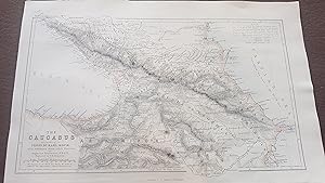
ORIGINAL 1856 MAP: The Caucasus according to Profr. Dr. Karl Koch with additions from other Sources by August Petermann
Swanston, G.H. ( engraver ) ; Augustus Petermann ( mapmaker ), Karl Koch.
Editorial: London and Edinburgh, A. Fullerton and Co., 1856, 1856
- Mapa
Librería: Treasure House Books, Franschhoek, WCAPE, Sur AfricaTreasure House Books
Contactar con el vendedorVendedor de 5 estrellasCondición: Usado - Excelente
EUR 15,33
Envío por EUR 42,00Se envía de Sur Africa a Estados Unidos de AmericaCantidad disponible: 1 disponibles
No Binding. Condición: Fine. Map iis in very clean attractive condition. map was removed from a disbound Gazetteer of the World published in 1856 by Fullarton. Would frame well. The map itself is 23 cm x 14 cm withn the border, and sheet is 17 cm x 26 cm. Steel engraving, very fine work, with three lithographic colours: black ou…tline, light blue, light brown. Looks to have been cleaned at some point. Would display beautifully. Includes the Black Sea, Caspian Sea, and regions in between including Georgia.
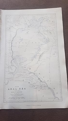
ORIGINAL 1856 MAP: The Aral Sea according to Khanikoff drawn by August Petermann
Swanston, G.H. ( engraver ) ; Augustus Petermann ( mapmaker ), Khanikoff.
Editorial: London and Edinburgh, A. Fullarton and Co., 1856, 1856
- Mapa
Librería: Treasure House Books, Franschhoek, WCAPE, Sur AfricaTreasure House Books
Contactar con el vendedorVendedor de 5 estrellasCondición: Usado - Excelente
EUR 15,33
Envío por EUR 42,00Se envía de Sur Africa a Estados Unidos de AmericaCantidad disponible: 1 disponibles
No Binding. Condición: Fine. The Aral Sea is a huge expanse between Kazakhstan and Uzbekistan, now almost completely dried up due to global warming, but in 1856, it's huge extent as an important sea was recorded in this historic map. Map is in very clean attractive condition. map was removed from a disbound Gazetteer of the Worl…d published in 1856 by Fullarton. Would frame well. The map itself is 23 cm x 14 cm withn the border, and sheet is 17 cm x 26 cm. Steel engraving, very fine work, with three lithographic colours: black outline, light blue, light brown. Looks to have been cleaned at some point. Would display beautifully.
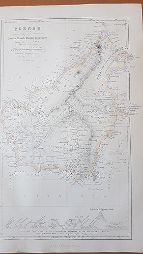
ORIGINAL 1856 MAP: Borneo by August Petermann
Swanston, G.H. ( engraver ) ; Augustus Petermann ( mapmaker ), van der Velde
Editorial: London and Edinburgh, A. Fullerton and Co., 1856, 1856
- Primera edición
- Mapa
Librería: Treasure House Books, Franschhoek, WCAPE, Sur AfricaTreasure House Books
Contactar con el vendedorVendedor de 5 estrellasCondición: Usado - Excelente
EUR 19,84
Envío por EUR 42,00Se envía de Sur Africa a Estados Unidos de AmericaCantidad disponible: 1 disponibles
No Binding. Condición: Fine. 1st Edition. Map is in very clean attractive condition. map was removed from a disbound Gazetteer of the World published in 1856 by Fullarton. Would frame well. The map itself is 23 cm x 14 cm withn the border, and sheet is 17 cm x 26 cm. Steel engraving, very fine work, with three lithographic colou…rs: black outline, light blue, light brown. Looks to have been cleaned at some point. Would display beautifully. Has an interesting sectional view at the bottom showing the comparitive elevations of the principal mountains and places of Borneo, serving as an index to the letters in the map. Paperback. No dj.
- Tapa blanda
- Impresión bajo demanda
Librería: Majestic Books, Hounslow, Reino UnidoMajestic Books
Contactar con el vendedorVendedor de 4 estrellasCondición: Nuevo
EUR 27,76
Envío por EUR 7,59Se envía de Reino Unido a Estados Unidos de AmericaCantidad disponible: 4 disponibles
Condición: New. Print on Demand pp. 210.

Editorial: London & Edinburgh: Arrowsmith & Co. c.1880, 1880
Librería: Peter Harrington. ABA/ ILAB., London, Reino UnidoPeter Harrington. ABA/ ILAB.
Contactar con el vendedorVendedor de 5 estrellasCondición: Usado
EUR 48,11
Envío por EUR 25,69Se envía de Reino Unido a Estados Unidos de AmericaCantidad disponible: 1 disponibles
Interesting little map detailing the heights of the mountain ranges and heights in Peru and Bolivia. Lithograph with printed colour. Very good condition. Size: 25.5 x 16.5 cm.
- Tapa dura
- Impresión bajo demanda
Librería: PBShop.store US, Wood Dale, IL, Estados Unidos de AmericaPBShop.store US
Contactar con el vendedorVendedor de 5 estrellasCondición: Nuevo
EUR 36,37
Gastos de envío gratisSe envía dentro de Estados Unidos de AmericaCantidad disponible: Más de 20 disponibles
HRD. Condición: New. New Book. Shipped from UK. THIS BOOK IS PRINTED ON DEMAND. Established seller since 2000.
- Tapa blanda
- Impresión bajo demanda
Librería: Books Puddle, New York, NY, Estados Unidos de AmericaBooks Puddle
Contactar con el vendedorVendedor de 4 estrellasCondición: Nuevo
EUR 33,30
Envío por EUR 3,49Se envía dentro de Estados Unidos de AmericaCantidad disponible: 4 disponibles
Condición: New. Print on Demand pp. 210.

Editorial: Fullarton & Co., UK, 1850
- Tapa blanda
Librería: Maynard & Bradley, Leicester, Reino UnidoMaynard & Bradley
Contactar con el vendedorVendedor de 5 estrellasCondición: Usado - Aceptable
EUR 114,26
Envío por EUR 25,63Se envía de Reino Unido a Estados Unidos de AmericaCantidad disponible: 1 disponibles
Softcover. Condición: Good. c.1850. Some wear around the outer edges has been carefully patched and repaired with conservation tape and sympathetically-coloured paper to prevent further tears and preserve the integrity of the title, but the printed content remains otherwise intact and well-presented with no major marks or signs…of wear across the image surface. Why on Amazon do most sellers not describe their actual book? Buy with confidence and support a genuine Independent Bricks & Mortar Real Bookshop. We are Maynard & Bradley CAMBO & PBFA(now lapsed) members here in Leicester City Centre. Size: 470 x 320 mm. 1. Item Type: Book. Quantity Available: 1. Shipped Weight: Under 500 grams. Category: Geography & Maps; Britain/UK; Modern; Inventory No: 34910.
- Tapa dura
- Impresión bajo demanda
Librería: PBShop.store UK, Fairford, GLOS, Reino UnidoPBShop.store UK
Contactar con el vendedorVendedor de 5 estrellasCondición: Nuevo
EUR 33,79
Envío por EUR 4,86Se envía de Reino Unido a Estados Unidos de AmericaCantidad disponible: Más de 20 disponibles
HRD. Condición: New. New Book. Delivered from our UK warehouse in 4 to 14 business days. THIS BOOK IS PRINTED ON DEMAND. Established seller since 2000.

Editorial: Gotha, 1877
- Tapa blanda
Librería: Antipodean Books, Maps & Prints, ABAA, Garrison, NY, Estados Unidos de AmericaAntipodean Books, Maps & Prints, ABAA
Contactar con el vendedorVendedor de 4 estrellasCondición: Usado - Bueno
EUR 148,78
Envío por EUR 8,75Se envía dentro de Estados Unidos de AmericaCantidad disponible: 1 disponibles
Condición: Very good condition. The map illustrates Ernest Giles 2nd expedition across Australia. The explorer's routes marked include Warburton, April 15, 1873 to January 26, 1874; Giles: August 1873 to June 1874; Forrest: Apirl 22 to September 27, 1874. It shows Western Australia from Shark's Bay north to 80 Mile Beach, just b…eyond present site of Port Hedland and east to Mt. Browne in South Australia. The Petermann Ranges feature just into South Australia, named for the cartographer/publisher, Augustus Petermann. 26 x 10". Original printed and outline color. Sir Thomas Elder was a Scottish-Australian pastoralist, highly successful businessman, philanthropist, politician, race-horse owner and breeder, and public figure. Amongst many other things, he is notable for introducing camels to Australia. Elder encouraged exploration, contributed largely to Warburton's 1873 expedition and Giles's in 1875, supplying camels in each case, which proved to be of the greatest value. He also contributed liberally to the cost of other explorations, and in no case sought or obtained any return for himself. On one occasion he offered £5,000 on condition that a like sum was subscribed by the public to finance an expedition to the Southern Ocean, but the condition was not fulfilled. William Ernest Powell Giles (1835 - 1897) was an Australian explorer who led five major expeditions in central Australia. (1835-1897)). Giles was bornin 1835 at Bristol, England, son of William Giles, merchant, and his wife Jane Elizabeth, née Powell. Educated at Christ's Hospital (where he was admitted as William Ernest Powell Giles) he followed his parents to Adelaide in 1850. He moved to Victoria in 1852, tried his luck on the goldfields without success and became a post office clerk in Melbourne. By 1861 he was in western New South Wales where until 1865 he engaged in several expeditions aimed at assessing the pastoral country beyond the Darling River. These journeys gave him both the experience and the taste for further exploration. In 1872, Giles was chosen to lead a small expedition organized by Dr Mueller to investigate parts of central Australia west of the new overland telegraph line. From Charlotte Waters the party followed the Finke Valley to the Missionaries' Plain south of the MacDonnell Ranges, but found its way blocked to the west by lack of water and to the south by the salt-pans of Lake Amadeus which Giles named. There his second-in-command, Carmichael, insisted on turning back despite Giles's wish to find a route to the coast of Western Australia. This ambition was to inspire his remaining expeditions, the first of which, again backed by Mueller, was assembled next year. Starting further south Giles followed the line of the Musgrave Ranges which, unknown to him, had just been discovered by Gosse. On reaching Mount Olga which he had earlier named from a distance, Giles found from Gosse's dray tracks that he had been anticipated but since they soon turned back he was encouraged to persevere. He spent the next summer trying to break through to the west from a base in the Tomkinson Range and in autumn persisted in attacking the desert from a northerly point in the Rawlinson Range. A desperate final effort cost him the life of one of his men, who gave his name to Gibson's Desert, and brought Giles himself close to death; the exhaustion of his supplies compelled him to retreat, defeated, to the overland telegraph line. Although forestalled by P. E. Warburton and John Forrest, Giles succeeded in his cherished aim of making an overland crossing from South to Western Australia in 1875. Equipped with camels by Thomas Elder, he set out from Beltana and went for supplies to Port Augusta whence he proceeded first north-west and then west along a string of waterholes, Wynbring, Ooldea, Ooldabinna and Boundary Dam, until he reached the Western Australian border. He then risked a 312-mile (502 km) marathon across the Great Victoria Desert before discovering the Queen Victoria Springs; from there.
- Tapa blanda
- Impresión bajo demanda
Librería: Biblios, frankfurt am main, HESSE, AlemaniaBiblios
Contactar con el vendedorVendedor de 4 estrellasCondición: Nuevo
EUR 27,87
Envío por EUR 9,95Se envía de Alemania a Estados Unidos de AmericaCantidad disponible: 4 disponibles
Condición: New. PRINT ON DEMAND pp. 210.
 Más imágenes
Editorial: Justus Perthes 1855, Gotha, 1855
- Tapa dura
Librería: Foster Books - Stephen Foster - ABA, ILAB, & PBFA, London, Reino UnidoFoster Books - Stephen Foster - ABA, ILAB, & PBFA
Contactar con el vendedorVendedor de 5 estrellasCondición: Usado - Aceptable
EUR 150,34
Envío por EUR 14,60Se envía de Reino Unido a Estados Unidos de AmericaCantidad disponible: 1 disponibles
Cloth Spine. Condición: Good. German language. vi, 378 pp. 23 lithographic maps, a couple of which are fold-out. Cloth spine with paper hand-written title labels over hard boards; corners covered in cloth. Wear and bumping to binding, including short patch of splitting to lower front joint, with binding being shaken. Foxing. Dr…Augustus Petermann worked for a time in Edinburgh, at W. & A. K. Johnston, and then London, before moving to Gotha, where he wrote this important geographical work. 4to. Map.
 Más imágenes
Editorial: S Orr & Co, London, 1850
- Tapa dura
- Primera edición
Librería: Barter Books Ltd, Alnwick, NORTH, Reino UnidoBarter Books Ltd
Contactar con el vendedorVendedor de 5 estrellasMiembro de asociación: IOBA
Condición: Usado - Aceptable
EUR 176,80
Envío por EUR 9,34Se envía de Reino Unido a Estados Unidos de AmericaCantidad disponible: 1 disponibles
Black hardback cloth cover. Condición: Good. First Edition. G: in good condition. Cover stained and partially faded. Shelf-wear. Chipping to spine ends, with some loss. Inner hinge cracking. Light browning to page edges. Sporadic foxing and marking. Some off-setting. 380mm x 290mm (15" x 11"). 142pp + plates. Colour frontispiece… + 13 [of 13] maps (2 double-page) + b/w vignettes. Extra shipping may be needed for overseas destinations. Heavy item - shipping supplement may apply for overseas.
 Más imágenes
Editorial: Wm S Orr and Co, 1854
- Tapa dura
Librería: Chapter House Books (Member of the PBFA), Sherborne, Reino UnidoChapter House Books (Member of the PBFA)
Contactar con el vendedorVendedor de 5 estrellasMiembro de asociación: PBFA
Condición: Usado
EUR 192,44
Envío por EUR 30,36Se envía de Reino Unido a Estados Unidos de AmericaCantidad disponible: 1 disponibles
Hardback. Rebound in half leather, cloth boards, marbled endpapers. Very good, no d/w. Leather scraped and marked, boards marked, pages yellowed, some pages marked. Very heavy book, will require extra postage - please email for exact postage quote and information on any available discounts.
 Más imágenes
Editorial: Published by Edward Stanford, London, 1866
- Tapa dura
- Mapa
Librería: Keoghs Books, Skipton, Reino UnidoKeoghs Books
Contactar con el vendedorVendedor de 5 estrellasMiembro de asociación: PBFA
Condición: Usado
EUR 240,55
Envío por EUR 32,70Se envía de Reino Unido a Estados Unidos de AmericaCantidad disponible: 1 disponibles
, linen backed map folded in 20 sections. Hand Coloured in outline. New Edition , close tears along joints of cover and an open tear at head of the spine, cover and title label faded, corners bumped, map is clean and in very good condition , map on linen folding into brown cloth cover, paper title label , 22 x 14 cm (folded), 85….5 x 63.5 cm (open) Map ISBN.
 Más imágenes
Editorial: Wm S.Orr & Co., 1850
- Tapa dura
- Primera edición
Librería: Brentwood Books, Kinnelon, NJ, Estados Unidos de AmericaBrentwood Books
Contactar con el vendedorVendedor de 5 estrellasCondición: Usado
EUR 450,85
Envío por EUR 3,48Se envía dentro de Estados Unidos de AmericaCantidad disponible: 1 disponibles
Hardcover. Condición: Collectable, very good. 1st. Original 1850 edition/printing. Very large hardcover (15.2"x11.5") bound in original dark blue cloth, gold lettering on spine and front cover, gilded page edges, frontispiece illustrates relative mountain heights, 142pp, 15 full-page color maps on heavy stock. Cover has slight w…ear--a little fraying at top and bottom of spine, slight rubbing and small tear on spine, gold lettering on spine a little dull; very small white paint mark on spine; binding weak around p77, a couple of pages are loosening, most tissues separating maps from text are missing or loose; name/date in neat old script on FFEP; small dampstain at lower right corner is visible on only the first few pages and the rear endpaper; moderate foxing at front of book up to and including frontispiece, else very minor foxing. Overall rather nice condition. OVERSIZE. ** We are a small family business selling fine new and pre-owned books online since 1999. We provide professional service and individual attention to your order, daily shipments, and sturdy packaging. FREE TRACKING ON ALL SHIPMENTS WITHIN USA.
 Más imágenes
Editorial: Augustus Petermann, Gotha, 1881
- Tapa blanda
Librería: Antipodean Books, Maps & Prints, ABAA, Garrison, NY, Estados Unidos de AmericaAntipodean Books, Maps & Prints, ABAA
Contactar con el vendedorVendedor de 4 estrellasCondición: Usado - Bueno
EUR 1091,06
Envío por EUR 8,75Se envía dentro de Estados Unidos de AmericaCantidad disponible: 1 disponibles
Condición: Very good condition. A collection of nine maps of Australian exploration from Petermann's Journal, from 1862 to 1881. Augustus Petermann studied and worked with famous German and English cartographers in the 1840's, and eventually established his Geographical Journal in 1855, which is published to this day. Through hi…s association with the Royal Geographical Society in London and later as the first head of the Geographical Institute in Gotha, he had extensive correspondence with a large number of explorers and travelers, who contributed the very latest information for the "Journal". His contacts from his R.G.S. days lead to many Australian explorations being reported in his "Journal" and nowhere else (eg. Lefroy 1864). The Petermann Ranges, in the west of South Australia, are named after him. Petermann's maps included much topographical and water system detail and were used to update such atlases as Stieler Hand Atlas. In 1869 Petermann encouraged the German push on the North Pole, organizing 2 expeditions. All maps are lithographs printed in color. [1862]. Provisorische Karte von Frank Gregory's reisen in Nordwest-Australien April bis June 1858 & Mai bis Oktober 1861. 9 3/4 x 8". WA from Sharks Bay to Cape Larry. (7) [1863]. Karte der Reise von C. & A. Dempster, Clarkson & Harper innern von West Australien Juli & August 1861. 17 x 10". From York to Lake Grace & Mt. Kennedy. Much detail of an expedition that was never published in English. (9) [1864]. Karte von H.M. Lefroy's Exploration innern von West-Australien Mai bis Juli 1863. 15 1/4 x 10". York to Mt. Robinson with Lake Moore in the top left corner. Never published in English. (10) [1869]. John Forrest's Reise im Innern von West-Australien April-Mai 1869. Nebst Ubersicht der Entdeckungen bis 1869. 17 x 10 1/2". Printed outline color. Perth to Murchison River inland to Hampton Plains and Lake Lefroy. Expedition routes include Forrest, AC Gregory, Dale, Austin, Roe, C & A Dempster, Moore, Lefroy & Robinson, F. Gregory, Hunt, Helpman. (20) [1874]. Vorlaufige Skizze von Gosse's & Warburton's Reisen durch West-Australien 1873-4 & Standpunkt der Geographischen Kenntniss dieses Gebietes in 1874. 10 1/2 x 13". Warburton's route from Perth to the overland telegraph, inset of Sydney. (24) [1874]. Thomas Elders' Expedition durch Inner-Australien von Beltana im Osten bis Perth im Western ausgefuhrt durch E. Giles Mai-Nov 1875. 26 x 10 1/2". SW Australia from Bunbury to Adelaide in the south, upper Murchison to north of Lake Eyre in the north. Very unusual projection, water and sea outlined in blue. (26) [1876]. Die Neuesten Entdeckung-reisen im Innern von Australien von Warburton Giles Forrest April 1873-Sept 74. 25 3/4 x 10". Sharks Bay to 90 Mile Beach over to Alice Springs. Much geographical detail on the inland exploration. (27) [1877]. Thomas Elders' Expedition durch Inner-Australien von Murchison im Westen, bis zum Neales im Osten, Ausgefuhrt durch E. Giles, April-Aug 1876. The map illustrates Ernest Giles 2nd expedition across Australia. The explorers' routes marked include Warburton, April 15, 1873 to January 26, 1874; Giles: August 1873 to June 1874; Forrest: April 22 to September 27, 1874. It shows Western Australia from Shark's Bay north to 80 Mile Beach, just beyond present site of Port Hedland and east to Mt. Browne in South Australia. The Petermann Ranges feature just into South Australia, named for the cartographer/publisher, Augustus Petermann. 26 x 10". [1881]. Nordwest-Australien und Timor Meer nach Alex Forrest's Forschungen 1879 und den Neuesten Nautischen Vemessumgen. 10 x 8". Outlines explorations by A. Forrest 1879; L. Leichhardt 1845; A. C. Gregory 1855-6; J. McD. Stuart 1862; J. McKinlay 1866; G. McMinn 1876; A. W. Sergison 1877; J. G. Brockman 1879-80. Map from south of Roebuck Bay -Coburg Peninsula. Towns and names in English, observations in German. (29).

- Tapa dura
- Impresión bajo demanda
Librería: True World of Books, Delhi, IndiaTrue World of Books
Contactar con el vendedorVendedor de 5 estrellasCondición: Nuevo
EUR 21,63
Gastos de envío gratisSe envía de India a Estados Unidos de AmericaCantidad disponible: 18 disponibles
LeatherBound. Condición: New. BOOKS ARE EXEMPT FROM IMPORT DUTIES AND TARIFFS; NO EXTRA CHARGES APPLY. LeatherBound edition. Condition: New. Reprinted from 1753 edition. Leather Binding on Spine and Corners with Golden leaf printing on spine. Bound in genuine leather with Satin ribbon page markers and Spine with raised gilt band…s. A perfect gift for your loved ones. Pages: 47 NO changes have been made to the original text. This is NOT a retyped or an ocr'd reprint. Illustrations, Index, if any, are included in black and white. Each page is checked manually before printing. As this print on demand book is reprinted from a very old book, there could be some missing or flawed pages, but we always try to make the book as complete as possible. Fold-outs, if any, are not part of the book. If the original book was published in multiple volumes then this reprint is of only one volume, not the whole set. Sewing binding for longer life, where the book block is actually sewn (smythe sewn/section sewn) with thread before binding which results in a more durable type of binding. Pages: 47.

- Tapa dura
- Impresión bajo demanda
Librería: True World of Books, Delhi, IndiaTrue World of Books
Contactar con el vendedorVendedor de 5 estrellasCondición: Nuevo
EUR 21,63
Gastos de envío gratisSe envía de India a Estados Unidos de AmericaCantidad disponible: 18 disponibles
LeatherBound. Condición: New. BOOKS ARE EXEMPT FROM IMPORT DUTIES AND TARIFFS; NO EXTRA CHARGES APPLY. LeatherBound edition. Condition: New. Reprinted from 1713 edition. Leather Binding on Spine and Corners with Golden leaf printing on spine. Bound in genuine leather with Satin ribbon page markers and Spine with raised gilt band…s. A perfect gift for your loved ones. Pages: 51 NO changes have been made to the original text. This is NOT a retyped or an ocr'd reprint. Illustrations, Index, if any, are included in black and white. Each page is checked manually before printing. As this print on demand book is reprinted from a very old book, there could be some missing or flawed pages, but we always try to make the book as complete as possible. Fold-outs, if any, are not part of the book. If the original book was published in multiple volumes then this reprint is of only one volume, not the whole set. Sewing binding for longer life, where the book block is actually sewn (smythe sewn/section sewn) with thread before binding which results in a more durable type of binding. Pages: 51.


