
Importe total (1 artículo artículos):
Destino del pedido:

weyss (23 resultados)
Ir a los resultados principales
Filtros de búsqueda
Tipo de artículo
- Todos los tipos de productos
- Libros (16)
- Revistas y publicaciones (No hay ningún otro resultado que coincida con este filtro.)
- Cómics (No hay ningún otro resultado que coincida con este filtro.)
- Partituras (No hay ningún otro resultado que coincida con este filtro.)
- Arte, grabados y pósters (3)
- Fotografías (No hay ningún otro resultado que coincida con este filtro.)
- Mapas (4)
- Manuscritos y coleccionismo de papel (No hay ningún otro resultado que coincida con este filtro.)
Condición Más información
- Nuevo (5)
- Como nuevo, Excelente o Muy bueno (5)
- Bueno o Aceptable (6)
- Regular o Pobre (No hay ningún otro resultado que coincida con este filtro.)
- Tal como se indica (7)
Encuadernación
Más atributos
- Primera edición (No hay ningún otro resultado que coincida con este filtro.)
- Firmado (No hay ningún otro resultado que coincida con este filtro.)
- Sobrecubierta (No hay ningún otro resultado que coincida con este filtro.)
- Con imágenes (16)
- No impresión bajo demanda (22)
Idioma (3)
Gastos de envío gratis
Ubicación del vendedor
Valoración de los vendedores
-

Poussičre scientifique
Librería: Ammareal, Morangis, Francia
Calificación del vendedor: 5 de 5 estrellas

EUR 3,50
Envío por EUR 16,50
Se envía de Francia a Estados Unidos de AmericaCantidad disponible: 1 disponibles
Ańadir al carritoSoftcover. Condición: Bon. Légčres traces d'usure sur la couverture. Edition 2013. Ammareal reverse jusqu'ŕ 15% du prix net de cet article ŕ des organisations caritatives. ENGLISH DESCRIPTION Book Condition: Used, Good. Slight signs of wear on the cover. Edition 2013. Ammareal gives back up to 15% of this item's net price to charity organizations.
-

Mein Mann, das Prachtexemplar, und ich: Szenen einer Ehe mit einem narzisstisch veranlagten Partner
Idioma: Alemán
Publicado por Independently published, 2017
ISBN 10: 1973167905 ISBN 13: 9781973167907
Librería: Revaluation Books, Exeter, Reino Unido
Calificación del vendedor: 5 de 5 estrellas
EUR 8,00
Envío por EUR 11,57
Se envía de Reino Unido a Estados Unidos de AmericaCantidad disponible: 1 disponibles
Ańadir al carritoPaperback. Condición: Brand New. 100 pages. German language. 8.00x5.00x0.25 inches. In Stock.
-

abgedated: von online-Typen und offline-Männern
Idioma: Alemán
Publicado por Independently published, 2019
ISBN 10: 1081352043 ISBN 13: 9781081352042
Librería: Revaluation Books, Exeter, Reino Unido
Calificación del vendedor: 5 de 5 estrellas
EUR 8,00
Envío por EUR 11,57
Se envía de Reino Unido a Estados Unidos de AmericaCantidad disponible: 1 disponibles
Ańadir al carritoPaperback. Condición: Brand New. 68 pages. German language. 8.50x5.50x0.16 inches. In Stock.
-

Frauenrechte - Menschenrechte: Vom Traum zur Wirklichkeit ÖED-Dokumentation 6
Idioma: Alemán
Publicado por OED Bildungsreferat; Wien, 1999
Librería: books4less (Versandantiquariat Petra Gros GmbH & Co. KG), Welling, Alemania
Calificación del vendedor: 5 de 5 estrellas
EUR 7,95
Envío por EUR 15,95
Se envía de Alemania a Estados Unidos de AmericaCantidad disponible: 1 disponibles
Ańadir al carritoSoftcover/Großformat. Condición: Gut. 171 Seiten; Rückensignatur, ordnungsgemäß vorne und hinten ausgestempelt, ansonsten gepflegtes, gut erhaltenes Buch aus aufgelöster Bibliothek einer großen deutschen Medienanstalt. Sprache: Deutsch Gewicht in Gramm: 550.
-

Das bäuerliche Kleid - bk1123
Idioma: Alemán
Publicado por Bayerischer Landwirtschaftsverlag, München, 1953
Librería: winni´s antiquariat, St. Georgen am Ybbsfelde, Austria
Calificación del vendedor: 4 de 5 estrellas

EUR 11,20
Envío por EUR 27,10
Se envía de Austria a Estados Unidos de AmericaCantidad disponible: 1 disponibles
Ańadir al carritoCondición: Gut bis sehr gut. Illustr.
-

Die Induktive Wärmebehandlung : Unter Besonderer Berücksichtigung Des Härtens Der Stähle -Language: german
Librería: GreatBookPrices, Columbia, MD, Estados Unidos de America
Calificación del vendedor: 5 de 5 estrellas
EUR 53,59
Envío por EUR 2,28
Se envía dentro de Estados Unidos de AmericaCantidad disponible: Más de 20 disponibles
Ańadir al carritoCondición: New.
-
Das Bauerliche Kleid
Idioma: Alemán
Publicado por Bayerischer Landwirtschaftsverlag, Munchen, 1953
Librería: Spenlow & Jorkins, Denver, CO, Estados Unidos de America
Calificación del vendedor: 5 de 5 estrellas
EUR 53,31
Envío por EUR 4,31
Se envía dentro de Estados Unidos de AmericaCantidad disponible: 1 disponibles
Ańadir al carritoHardcover. Condición: Good. Friedl Lampel-Weyss Ilustrador. *Attractive vintage book with the patterns page* A short magazine article is laid in. Square, solid, unmarked, and bright with some edgewear and a couple of gashes to the front cover. A very pleasant interior. 38 pp with illustrations throughout, including full page color plates. In German. Ships from Colorado.
-

Die Induktive Wärmebehandlung : Unter Besonderer Berücksichtigung Des Härtens Der Stähle -Language: german
Librería: GreatBookPricesUK, Woodford Green, Reino Unido
Calificación del vendedor: 5 de 5 estrellas
EUR 59,83
Envío por EUR 17,36
Se envía de Reino Unido a Estados Unidos de AmericaCantidad disponible: Más de 20 disponibles
Ańadir al carritoCondición: New.
-
Mein Mann, das Prachtexemplar, und ich: Szenen einer Ehe mit einem narzisstisch veranlagten Partner
Idioma: Alemán
Publicado por Independently published, 2017
ISBN 10: 1973167905 ISBN 13: 9781973167907
Librería: Buchpark, Trebbin, Alemania
Calificación del vendedor: 5 de 5 estrellas
EUR 7,69
Envío por EUR 105,00
Se envía de Alemania a Estados Unidos de AmericaCantidad disponible: 1 disponibles
Ańadir al carritoCondición: Sehr gut. Zustand: Sehr gut | Seiten: 100 | Sprache: Deutsch | Produktart: Bücher | Keine Beschreibung verfügbar.
-

Die Induktive Wärmebehandlung : Unter Besonderer Berücksichtigung Des Härtens Der Stähle -Language: german
Librería: GreatBookPricesUK, Woodford Green, Reino Unido
Calificación del vendedor: 5 de 5 estrellas
EUR 110,85
Envío por EUR 17,36
Se envía de Reino Unido a Estados Unidos de AmericaCantidad disponible: Más de 20 disponibles
Ańadir al carritoCondición: As New. Unread book in perfect condition.
-

Die Induktive Wärmebehandlung : Unter Besonderer Berücksichtigung Des Härtens Der Stähle -Language: german
Librería: GreatBookPrices, Columbia, MD, Estados Unidos de America
Calificación del vendedor: 5 de 5 estrellas
EUR 131,82
Envío por EUR 2,28
Se envía dentro de Estados Unidos de AmericaCantidad disponible: Más de 20 disponibles
Ańadir al carritoCondición: As New. Unread book in perfect condition.
-

Brownsville - Texas
Publicado por U.S.A, 1858
Librería: Alexandre Antique Prints, Maps & Books, Toronto, ON, Canada
Miembro de asociación: ABAC ILAB
Calificación del vendedor: 4 de 5 estrellas
Arte / Grabado / Póster
EUR 133,28
Envío por EUR 5,18
Se envía de Canada a Estados Unidos de AmericaCantidad disponible: 1 disponibles
Ańadir al carritoCondición: Excellent Condition. Image Size : 149x210 (mm), 5.875x8.25 (Inches), Platemark Size : , Paper Size : 216x287 (mm), 8.5x11.25 (Inches), Black & White, Steel Engraving.
-
Brownsville--Texas
Publicado por Washington, D.C., 1857
Librería: Alexandre Antique Prints, Maps & Books, Toronto, ON, Canada
Miembro de asociación: ABAC ILAB
Calificación del vendedor: 4 de 5 estrellas
Arte / Grabado / Póster
EUR 199,92
Envío por EUR 5,18
Se envía de Canada a Estados Unidos de AmericaCantidad disponible: 1 disponibles
Ańadir al carritoCondición: Very Good. Image Size : 149x208 (mm), 5.87x8.19 (Inches), Platemark Size : , Paper Size : 220x287 (mm), 8.66x11.30 (Inches), Hand Colored, Engraving.
-
Falls of the Rio Salado.
Publicado por Sarony & Co., c.1857, New York, 1857
Librería: Alexandre Antique Prints, Maps & Books, Toronto, ON, Canada
Miembro de asociación: ABAC ILAB
Calificación del vendedor: 4 de 5 estrellas
Arte / Grabado / Póster
EUR 244,35
Envío por EUR 5,18
Se envía de Canada a Estados Unidos de AmericaCantidad disponible: 1 disponibles
Ańadir al carritoCondición: Very Good. View of Falls of the Rio Salado in southern USA bordering Mexico. , Image Size : 137x211 (mm), 5.39x8.31 (Inches), Platemark Size : , Paper Size : 220x287 (mm), 8.66x11.30 (Inches), Hand Colored, Lithograph.
-

Military Map Showing the Topographical Features of the Country Adjacent to Harper's Ferry, Va.; Including Maryland, Loudoun, and Bolivar Heights, and Portions of South and Short Mountains .
Publicado por Washington, Washington, 1876
Librería: High Ridge Books, Inc. - ABAA, South Deerfield, MA, Estados Unidos de America
Miembro de asociación: ABAA ESA ILAB SNEAB
Calificación del vendedor: 5 de 5 estrellas
EUR 244,35
Envío por EUR 7,85
Se envía dentro de Estados Unidos de AmericaCantidad disponible: 1 disponibles
Ańadir al carritoUncolored map of the area around Harper's Ferry, showing the western tip of Maryland to the north and east, Virginia to the south and west, with the Potomac and Shenandoah Rivers providing the dividing lines. Fine condition. Very detailed map showing elevations by hachure, houses, and some land owners. This map was issued by the U.S. Army as one of the series of maps issued in 1876. It is not the reduced version of the map which was issued with the Atlas to Accompany the Official Records of 1891-93. Stephenson 700.
-
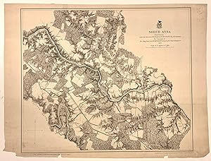
North Anna; From Surveys under the direction of Bvt. Brig. Gen. N. MICHLER, Maj. or Engineers By Command of Bvt. Maj. Gen 1 A.A. HUMPHREYS, Brig. Gen 1 & Chief of Engineers
Publicado por U.S. War Department, 1869
Librería: Argosy Book Store, ABAA, ILAB, New York, NY, Estados Unidos de America
Miembro de asociación: ABAA ILAB
Calificación del vendedor: 5 de 5 estrellas
EUR 310,99
Envío por EUR 5,18
Se envía dentro de Estados Unidos de AmericaCantidad disponible: 1 disponibles
Ańadir al carritounbound. Map. Photolithograph with hand coloring. Sheet measures 16.5" x 22.5". Detailed map, and plan showing North Anna in Virginia. The Battle of North Anna was fought in 1864, as part of Union Lt. Gen. Ulysses S. Grant's Overland Campaign against Confederate Gen. Robert E. Lee's Army of Northern Virginia This unusual map was part of a series of surveys by the U.S. War Department, showing all topographical features, private residences, railroads, waterways, major routes and significant landmarks, with relief in hachures. Published in the atlas "Military Maps Illustrating the Operations of the Armies Of The Potomac & James May 4th 1864 to April 9th 1865 including Battlefields of the Wilderness, Spottsylvania, North Anna, Totopotomoy, Cold Harbor, The Siege Of Petersburg And Richmond Battle-fields of Five Forks", 1869. Some pieces missing from lower border. Major John E. Weyss was a topographical engineer and surveyor.
-
Jeterseville and Sailors Creek From Surveys under the direction of Bvt. Brig. Gen. N. Michler, Maj. of Engineers By Command of Bvt. Maj. Genl. A.A. Humphreys, Brig. Genl. & Chief of Engineers 1867
Publicado por U.S. War Department, 1869
Librería: Argosy Book Store, ABAA, ILAB, New York, NY, Estados Unidos de America
Miembro de asociación: ABAA ILAB
Calificación del vendedor: 5 de 5 estrellas
EUR 444,28
Envío por EUR 5,18
Se envía dentro de Estados Unidos de AmericaCantidad disponible: 1 disponibles
Ańadir al carritounbound. Condición: very good. Map. Photolithograph lined with canvas. Image measures 19.75" x 33.75". Beautifully detailed Civil War map, showing Jetersville in Virginia, southwest of Richmond. This unusual map was part of a series of surveys by the U.S. War Department, showing all topographical features, private residences, railroads, waterways, major routes and significant landmarks, with relief in hachures. Published in the atlas "Military Maps Illustrating the Operations of the Armies Of The Potomac & James May 4th 1864 to April 9th 1865 including Battlefields of the Wilderness, Spottsylvania, North Anna, Totopotomoy, Cold Harbor, The Siege Of Petersburg And Richmond Battle-fields of Five Forks", 1869. Creasing and chips to original centerfold and edges. Reinforcements to corners. Major John E. Weyss was a topographical engineer and surveyor. Hard to find.
-
![Imagen del vendedor de Parentatio Sueco-Regia: Das ist: Christliche Leich-Predigt uber und bey tödtlichem, trawrigen Abgang, Deß weyland durchleuchtigsten, großmächtigsten und hochgeborenen Fürsten und Herrns, Herrns Gustavi Adolphi, der Schweden, Gothen und Wenden Königes [.]. Unsers, die wir sampt und sonders augspurglicher, ungeänderter Lutherischen Confession zugethan, allergnädigsten Herrens, hoch- mild und seeligster königl. Mayestät Gedächtnuß. Am lieben newen JahrsTag der Gemeine zu Altenkültz geprediget [.], durch Danielem Weyssium, designirten Pfarrherrn zu Pferdsfeldt. a la venta por Centralantikvariatet](https://pictures.abebooks.com/inventory/md/md31062284362.jpg)
Parentatio Sueco-Regia: Das ist: Christliche Leich-Predigt uber und bey tödtlichem, trawrigen Abgang, Deß weyland durchleuchtigsten, großmächtigsten und hochgeborenen Fürsten und Herrns, Herrns Gustavi Adolphi, der Schweden, Gothen und Wenden Königes [.]. Unsers, die wir sampt und sonders augspurglicher, ungeänderter Lutherischen Confession zugethan, allergnädigsten Herrens, hoch- mild und seeligster königl. Mayestät Gedächtnuß. Am lieben newen JahrsTag der Gemeine zu Altenkültz geprediget [.], durch Danielem Weyssium, designirten Pfarrherrn zu Pferdsfeldt.
Librería: Centralantikvariatet, Stockholm, Suecia
Miembro de asociación: ILAB SVAF
Calificación del vendedor: 5 de 5 estrellas
EUR 236,30
Envío por EUR 25,00
Se envía de Suecia a Estados Unidos de AmericaCantidad disponible: 1 disponibles
Ańadir al carritoCondición: Very Good. Frankfurt am Main, Joh-Nicolaus Stoltzenberger, 1633. 4:o. 23,+ 32-39 s. Häftad med marmorerad ryggremsa. Fint exemplar ur Ericsbergs bibliotek.VD17 39:137451M. Daniel Weyss var präst i den lill orten Pferdsfeld i Rheinland-Pfalz, vilken övergavs 1980 när en ny Natoflygplats skulle byggas. Softcover / Paperback.
-

Cold Harbor.
Ańo de publicación: 1867
Librería: Geographicus Rare Antique Maps, Brooklyn, NY, Estados Unidos de America
Miembro de asociación: ABAA ESA ILAB
Calificación del vendedor: 4 de 5 estrellas
Mapa
EUR 373,19
Envío por EUR 14,67
Se envía dentro de Estados Unidos de AmericaCantidad disponible: 1 disponibles
Ańadir al carritoVery good. Verso repairs to centerfold separations. Exhibits light dampstaining in margins. Size 21.75 x 33 Inches. This is an 1867 John Weyss and Nathaniel Michler map of the battlefield of Cold Harbor, Virginia. The map depicts from the Virginia Central Railroad to Emanuel Church and Black Creek Church and from the Linney Farm to the Taylor Farm. The last battle of Union Lieutenant General Ulysses S. Grant's Overland Campaign, the Battle of Cold Harbor was a lopsided victory for General Robert E. Lee and the Confederacy, but it would prove to be his last. Grant had achieved the goal of the Overland Campaign and forced Lee into defending Richmond, the capital of the Confederacy, and Petersburg behind a network of trenches and other fortifications. Soon after the Battle of Cold Harbor, the Richmond-Petersburg Campaign, more popularly known as the Siege of Petersburg, began. This campaign was a nine-month saga of trench warfare and small battles, culminating in the capture of Petersburg and the evacuation of Richmond by the Confederate government. The Battle of Cold Harbor The Battle of Cold Harbor, which took place only ten miles from Richmond, is remembered as one of the bloodiest, most lopsided battles in American history. General Grant and the Union Army were trying to seize control of the crossroads at Cold Harbor, Virginia, which would have given them access to Richmond. After the initial success of the Union cavalry, Grant sent numerous infantry assaults against well entrenched Confederate lines. Lee's forces held off attacks by the numerically superior Federal army and inflicted egregious casualties, with some estimates calculating nearly 13,000 Union casualties compared with just over 5,000 Confederate losses. In his memoirs, General Grant stated that he had 'always regretted that the last assault at Cold Harbor was ever madeNo advantage whatever was gained to compensate for the heavy loss we sustained.' Publication History and Census This map was surveyed and drawn by Major John E. Weyss under the command of Nathaniel Michler, engraved by Julius Bien, and published by the War Department in Military Maps illustrating the Operations of the Armies of the Potomac and James in 1869. While this map is well represented in institutional collections, it is rare to the private market. References: Rumsey 3881.008.
-

High Bridge and Farmville.
Ańo de publicación: 1867
Librería: Geographicus Rare Antique Maps, Brooklyn, NY, Estados Unidos de America
Miembro de asociación: ABAA ESA ILAB
Calificación del vendedor: 4 de 5 estrellas
Mapa
EUR 373,19
Envío por EUR 14,67
Se envía dentro de Estados Unidos de AmericaCantidad disponible: 1 disponibles
Ańadir al carritoVery good. Mounted on linen. Closed margin tear professionally repaired on verso. Blank on verso. Size 22.5 x 31 Inches. This is an 1867 John Weyss and Nathaniel Michler map of the Battle of High Bridge, Virginia (1865) - a late American Civil War (1861- 1865) engagement of the Appomattox Campaign. The map depicts the region from the farmstead of A. Adams to the Parkinson homestead and from the home of H. Burt to Rice's Depot. Numerous other homesteads, farmsteads, churches, and mills are identified, along with Farmville and Jamestown on the Appomattox River, and Rice's Depot. The map highlights roads in the region, including the important Agola Road. The Battle of High Bridge The Battle of High Bridge was a series of two engagements near the end of the Appomattox Campaign. They were fought four miles northeast of Farmville on April 6 and 7, 1865, in the final days of the war. The battles were part of General Robert E. Lee's retreat from Richmond and his effort to join General Joseph E. Johnston's force in North Carolina. The action focused on Confederate attempts to secure the South Side Railroad's 'High Bridge' as well as the lower wagon bridge, both crossing the Appomattox, so as to ease their retreat. A large Union raiding party intending to destroy the bridges was soundly defeated by the larger retreating Confederate force. After successfully crossing the Appomattox, the Confederates attempted to burn both bridges to hinder Union pursuit. They successfully sabotaged the High Bridge, but the Union forces were able to save the wagon bridge and used it to continue their pursuit of Lee and his army. Publication History and Census This map was surveyed and drawn by Major John E. Weyss under the command of Nathaniel Michler, engraved by Julius Bien, and published by the War Department in Military Maps illustrating the Operations of the Armies of the Potomac and James in 1869. While this map is well represented in institutional collections, it is rare on the private market. References: Rumsey 3881.013. OCLC 56114112.
-

Bermuda Hundred.
Ańo de publicación: 1867
Librería: Geographicus Rare Antique Maps, Brooklyn, NY, Estados Unidos de America
Miembro de asociación: ABAA ESA ILAB
Calificación del vendedor: 4 de 5 estrellas
Mapa
EUR 373,19
Envío por EUR 14,67
Se envía dentro de Estados Unidos de AmericaCantidad disponible: 1 disponibles
Ańadir al carritoVery good. Verso repairs to centerfold separations in margins. Light damp staining in margins. Blank on verso. Size 20.25 x 30 Inches. This is an 1867 John Weyss and Nathaniel Michler map of the Bermuda Hundred Campaign during the American Civil War. The map depicts the region from the Dunnson farm to the Jordan's Point Lighthouse on the James River and from Chaffin's Bluff and Drury's (Drewry's) Bluff to the J. Mason farm. The Bermuda Hundred Campaign A series of battles fought in May 1864, the Bermuda Hundred Campaign was fought between the Union Army of the James led by Major General Benjamin Butler and a much smaller Confederate force under the command of General P.G.T. Beauregard. Butler and the Army of the James landed at Bermuda Hundred, a fishing village situated on a peninsula at the confluence of the Appomattox and James Rivers between Richmond and Petersburg, Virginia, on May 5, the same day that General Grant and the Army of the Potomac launched the Overland Campaign at the Battle of the Wilderness. With the ultimate aim of severing the Richmond and Petersburg Railroad, a vital rail link to the south, a series of battles ensued. Many of these battles happened at locations labeled here, including the Battle of Port Walthall Junction, the Battle of Chester Station, the Battle of Proctor's Creek (also known as the Battle of Drewry's Bluff), and the Battle of Ware Bottom Church. Although Butler commanded a superior force to that of Beauregard, the best he was able to achieve was a stalemate. Butler was one of the 'political generals' appointed because of their loyalty to Lincoln and his reelection campaign and was not a very talented commander. Even with two very talented subordinates, Butler and the Army of the James were 'bottled-up' in the vicinity of Bermuda Station and were not able to occupy a large number of Confederate forces, allowing these Confederate soldiers to be reassigned to fight General Grant's Army of the Potomac at Cold Harbor and elsewhere. A Closer Look at the Map With Confederate forces noted in red and Federal (Union) forces in blue, the many actions of the Bermuda Hundred Campaign are illustrated here, although the progression of the campaign is not noted. Numerous forts, batteries, and other locations integral to the fighting are illustrated and labeled, as are myriad farms and homesteads. Roads and railroads, including the Richmond and Petersburg Railroad, the Richmond and Petersburg Turnpike, and the Petersburg and City Point Railroad, are also identified. Publication History and Census This map was surveyed and drawn by Major John E. Weyss under the command of Nathaniel Michler, engraved by Julius Bien, and published by the War Department in Military Maps illustrating the Operations of the Armies of the Potomac and James in 1869. While this map is well represented in institutional collections, it is rarely on the private market. References: Rumsey 3881.010. OCLC 56794786.
-

Appomattox Court House.
Ańo de publicación: 1867
Librería: Geographicus Rare Antique Maps, Brooklyn, NY, Estados Unidos de America
Miembro de asociación: ABAA ESA ILAB
Calificación del vendedor: 4 de 5 estrellas
Mapa
EUR 447,83
Envío por EUR 14,67
Se envía dentro de Estados Unidos de AmericaCantidad disponible: 1 disponibles
Ańadir al carritoVery good. Light toning along original centerfold. Verso repairs to margin tears. Blank on verso. Size 31.25 x 22.5 Inches. This is an 1867 John Weyss and Nathaniel Michler map of Appomattox Court House, Virginia, where the American Civil War came to a close. The map depicts the region from Appomattox Station on the South Side Railroad to the Jenkins homestead and from the homestead of L. Marshall to Evergreen Station. Beautifully engraved, the area surrounding Appomattox Court House is illustrated in detail, with numerous homesteads noted throughout. Roads traverse the area, along with the South Side Railroad, and rivers and streams are noted. Forests and hills are also included. Troop locations and movements, however, are not depicted. Appomattox Court House and the American Civil War Appomattox Court House is the name of a village in central Virginia. Originally known as Clover Hill, it was renamed Appomattox Court House after its newly built courthouse. The hamlet declined in importance through the 1840s and 1850s, particularly after the rail network bypassed it in favor of nearby Appomattox Station. During the Civil War, Appomattox Court House consisted of about 'five houses, a tavern, and a courthouse' along a single street, which itself was boarded up at one end to keep the cows out.' This sleepy hamlet was nonetheless the site of the final battle of the American Civil War, the Battle of Appomattox Court House, and of the surrender of General Robert E. Lee's Army of Northern Virginia to Union General Ulysses S. Grant. Today, Appomattox Court House is a National Historical Park and is administered by the National Park Service. Census and Publication History This map was surveyed and drawn by Major John E. Weyss under the command of Brevet Brigadier General Nathaniel Michler, engraved by Julius Bien, and published by the War Department in Military Maps illustrating the Operations of the Armies of the Potomac and James in 1869. While this map is well represented in institutional collections, it is rarely on the private market. References: Rumsey 3881.014. Philips (Atlases) P843.
-
Clag vnd vormanu[n]g gegen dem übermässigen vnchristlichen gewalt des Bapsts zu Rom, vnd der vngeistliche[n] geistlichen [1520] [Leather Bound]
Ańo de publicación: 2025
Librería: Gyan Books Pvt. Ltd., Delhi, India
Calificación del vendedor: 5 de 5 estrellas
EUR 61,82
Gastos de envío gratis
Se envía de India a Estados Unidos de AmericaCantidad disponible: Más de 20 disponibles
Ańadir al carritoLeather Bound. Condición: New. Language: German. Language: German. Presenting an Exquisite Leather-Bound Edition, expertly crafted with Original Natural Leather that gracefully adorns the spine and corners. The allure continues with Golden Leaf Printing that adds a touch of elegance, while Hand Embossing on the rounded spine lends an artistic flair. This masterpiece has been meticulously reprinted in 2025, utilizing the invaluable guidance of the original edition published many years ago in [1520]. The contents of this book are presented in classic black and white. Its durability is ensured through a meticulous sewing binding technique, enhancing its longevity. Imprinted on top-tier quality paper. A team of professionals has expertly processed each page, delicately preserving its content without alteration. Due to the vintage nature of these books, every page has been manually restored for legibility. However, in certain instances, occasional blurriness, missing segments, or faint black spots might persist. We sincerely hope for your understanding of the challenges we faced with these books. Recognizing their significance for readers seeking insight into our historical treasure, we've diligently restored and reissued them. Our intention is to offer this valuable resource once again. We eagerly await your feedback, hoping that you'll find it appealing and will generously share your thoughts and recommendations. Lang: - German, Pages:- 60, Print on Demand. If it is a multi-volume set, then it is only a single volume. We are specialised in Customisation of books, if you wish to opt different color leather binding, you may contact us. This service is chargeable. Product Disclaimer: Kindly be informed that, owing to the inherent nature of leather as a natural material, minor discolorations or textural variations may be perceptible. Explore the FOLIO EDITION (12x19 Inches): Available Upon Request. 60 60.


![Imagen del vendedor de Clag vnd vormanu[n]g gegen dem übermässigen vnchristlichen gewalt des Bapsts zu Rom, vnd der vngeistliche[n] geistlichen [1520] [Leather Bound] a la venta por Gyan Books Pvt. Ltd.](https://pictures.abebooks.com/inventory/md/md32007382009.jpg)