J e weyss (3 resultados)

Editorial: Sarony & Co., c.1857, New York 1857
- Lámina artística
Librería: Alexandre Antique Prints, Maps & Books, Toronto, ON, CanadaAlexandre Antique Prints, Maps & Books
Contactar con el vendedorVendedor de 4 estrellasCondición: Usado - Bueno
EUR 244,35
Envío por EUR 5,18Se envía de Canada a Estados Unidos de AmericaCantidad disponible: 1 disponibles
Condición: Very Good. View of Falls of the Rio Salado in southern USA bordering Mexico. , Image Size : 137x211 (mm), 5.39x8.31 (Inches), Platemark Size : , Paper Size : 220x287 (mm), 8.66x11.30 (Inches), Hand Colored, Lithograph.
Editorial: U.S. War Department 1869
Librería: Argosy Book Store, ABAA, ILAB, New York, NY, Estados Unidos de AmericaArgosy Book Store, ABAA, ILAB
Contactar con el vendedorVendedor de 5 estrellasCondición: Usado
EUR 310,99
Envío por EUR 5,18Se envía dentro de Estados Unidos de AmericaCantidad disponible: 1 disponibles
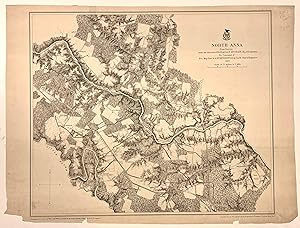
unbound. Map. Photolithograph with hand coloring. Sheet measures 16.5" x 22.5". Detailed map, and plan showing North Anna in Virginia. The Battle of North Anna was fought in 1864, as part of Union Lt. Gen. Ulysses S. Grant's Overland Campaign against Confederate Gen. Robert E. Lee's Army of Northern Virginia This unusual map was… part of a series of surveys by the U.S. War Department, showing all topographical features, private residences, railroads, waterways, major routes and significant landmarks, with relief in hachures. Published in the atlas "Military Maps Illustrating the Operations of the Armies Of The Potomac & James May 4th 1864 to April 9th 1865 including Battlefields of the Wilderness, Spottsylvania, North Anna, Totopotomoy, Cold Harbor, The Siege Of Petersburg And Richmond Battle-fields of Five Forks", 1869. Some pieces missing from lower border. Major John E. Weyss was a topographical engineer and surveyor.
 Más imágenes
Editorial: U.S. War Department 1869
Librería: Argosy Book Store, ABAA, ILAB, New York, NY, Estados Unidos de AmericaArgosy Book Store, ABAA, ILAB
Contactar con el vendedorVendedor de 5 estrellasCondición: Usado - Bueno
EUR 444,28
Envío por EUR 5,18Se envía dentro de Estados Unidos de AmericaCantidad disponible: 1 disponibles
unbound. Condición: very good. Map. Photolithograph lined with canvas. Image measures 19.75" x 33.75". Beautifully detailed Civil War map, showing Jetersville in Virginia, southwest of Richmond. This unusual map was part of a series of surveys by the U.S. War Department, showing all topographical features, private residences, ra…ilroads, waterways, major routes and significant landmarks, with relief in hachures. Published in the atlas "Military Maps Illustrating the Operations of the Armies Of The Potomac & James May 4th 1864 to April 9th 1865 including Battlefields of the Wilderness, Spottsylvania, North Anna, Totopotomoy, Cold Harbor, The Siege Of Petersburg And Richmond Battle-fields of Five Forks", 1869. Creasing and chips to original centerfold and edges. Reinforcements to corners. Major John E. Weyss was a topographical engineer and surveyor. Hard to find.

