
Importe total (1 artículo artículos):
Destino del pedido:

rev moule (57 resultados)
Ir a los resultados principales
Filtros de búsqueda
Tipo de artículo
- Todos los tipos de productos
- Libros (32)
- Revistas y publicaciones (No hay ningún otro resultado que coincida con este filtro.)
- Cómics (No hay ningún otro resultado que coincida con este filtro.)
- Partituras (No hay ningún otro resultado que coincida con este filtro.)
- Arte, grabados y pósters (No hay ningún otro resultado que coincida con este filtro.)
- Fotografías (No hay ningún otro resultado que coincida con este filtro.)
- Mapas (25)
- Manuscritos y coleccionismo de papel (No hay ningún otro resultado que coincida con este filtro.)
Condición Más información
- Nuevo (19)
- Como nuevo, Excelente o Muy bueno (No hay ningún otro resultado que coincida con este filtro.)
- Bueno o Aceptable (8)
- Regular o Pobre (3)
- Tal como se indica (27)
Encuadernación
Más atributos
- Primera edición (1)
- Firmado (No hay ningún otro resultado que coincida con este filtro.)
- Sobrecubierta (1)
- Con imágenes (44)
- No impresión bajo demanda (42)
Idioma (2)
Gastos de envío gratis
Ubicación del vendedor
Valoración de los vendedores
-

THE EPISTLE TO THE PHILIPPIANS WITH INTRODUCTION AND NOTES
Publicado por Cambridge University Press, Cambridge, 1889
Librería: Neil Shillington: Bookdealer/Booksearch, Hobe sound, FL, Estados Unidos de America
Calificación del vendedor: 4 de 5 estrellas

EUR 5,77
Envío por EUR 5,13
Se envía dentro de Estados Unidos de AmericaCantidad disponible: 1 disponibles
Ańadir al carritoHardback. Condición: Very Good. Owners Name Inside; for :schools and universities"; 134 pages.
-
MY BRETHREN & COMPANIONS by H. C. G MOULE H/B 1905 Pub.JAMES NISBET
Idioma: Inglés
Publicado por JAMES NISBET AND Co LTD, 1905
Librería: Happyfish Books, Meopham, KENT, Reino Unido
Calificación del vendedor: 4 de 5 estrellas
EUR 11,90
Envío por EUR 23,13
Se envía de Reino Unido a Estados Unidos de AmericaCantidad disponible: 1 disponibles
Ańadir al carritoHardcover. Condición: Good. No Jacket. THE BOOK HAS SOME RUBBING AND WEAR TO THE EDGES AND CORNERS. THE SPINE IS FADED WITH GOLD GLINT WRITING. THE PAGES ARE GENERALLY CLEAN AND CREASE FREE. PREVIOUS OWNERS NAME PENNED INSIDE FRONT COVER. THE BINDING IS FIRM. THIS IS A GOOD EXAMPLE OF THIS HARD TO FIND EDITION.
-

The Epistle to the Ephesians
Publicado por Cambridge at the University Press, 1893
Librería: World of Rare Books, Goring-by-Sea, SXW, Reino Unido
Calificación del vendedor: 5 de 5 estrellas

EUR 19,06
Envío por EUR 5,57
Se envía de Reino Unido a Estados Unidos de AmericaCantidad disponible: 1 disponibles
Ańadir al carritoCondición: Good. 1893. No Edition Stated. 175 pages. No dust jacket. Blue cloth with black lettering. Clean pages with firm binding. Notable foxing and tanning to endpapers and page edges. Previous owner's name stamp to front paste down. Mild wear and bumping to spine, board edges and corners, with scuffing and marking to boards. Notable sunning to spine.
-

The Epistle of Paul the Apostle to the Romans
Publicado por Cambridge at The University Press, 1894
Librería: World of Rare Books, Goring-by-Sea, SXW, Reino Unido
Calificación del vendedor: 5 de 5 estrellas
EUR 19,06
Envío por EUR 5,57
Se envía de Reino Unido a Estados Unidos de AmericaCantidad disponible: 1 disponibles
Ańadir al carritoCondición: Good. 1894. No Edition Stated. 270 pages. No dust jacket. Blue cloth with black lettering. Clean pages. Notable foxing and tanning to endpapers and page edges. Previous owner's name stamp to front paste down. Some gutter cracking. Mild wear and bumping to spine, board edges and corners, with scuffing and marking to boards. Notable tanning to spine.
-
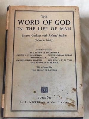
THE WORD OF GOD IN THE LIFE OF MAN - SERMON OUTLINES WITH RELATED STUDIES (ADVENT TO TRINITY)
Idioma: Inglés
Publicado por A. R. MOWBRAY AND CO, 1964
Librería: Happyfish Books, Meopham, KENT, Reino Unido
Calificación del vendedor: 4 de 5 estrellas
EUR 17,86
Envío por EUR 23,13
Se envía de Reino Unido a Estados Unidos de AmericaCantidad disponible: 1 disponibles
Ańadir al carritoHardcover. Condición: Good. Dust Jacket Included. DUST WRAPPER COVER RUBBED AND CREASED WITH STAINING TO THE FRONT (NO TEXT AFFECTED). SOME SCUFFING TO EDGES AND CORNERS. SOME FOXING ON COVER AND OUTER EDGES. SOME TANNING TO INSIDE PAGES. BINDING TIGHT. PAGES GENERALLY APPEAR CLEAN AND CREASE FREE. ALL IN ALL A NICE EXAMPLE OF THIS BOOK.
-
Thoughts for the Sundays of the Year
Librería: Christian Value Books, Papanui, Nueva Zelanda
Calificación del vendedor: 4 de 5 estrellas
EUR 3,65
Envío por EUR 21,53
Se envía de Nueva Zelanda a Estados Unidos de AmericaCantidad disponible: 1 disponibles
Ańadir al carritoHardcover/Hardback. Condición: Fair. No Description.
-
Grace and Godliness - Studies in the Epistle to the Ephesians
Librería: Christian Value Books, Papanui, Nueva Zelanda
Calificación del vendedor: 4 de 5 estrellas
EUR 4,17
Envío por EUR 21,53
Se envía de Nueva Zelanda a Estados Unidos de AmericaCantidad disponible: 1 disponibles
Ańadir al carritoHardcover/Hardback. Condición: Fair. No Description.
-

Four Hundred Millions. Chapters on China and the Chinese
Librería: Ria Christie Collections, Uxbridge, Reino Unido
Calificación del vendedor: 5 de 5 estrellas
EUR 37,55
Envío por EUR 13,86
Se envía de Reino Unido a Estados Unidos de AmericaCantidad disponible: Más de 20 disponibles
Ańadir al carritoCondición: New. In.
-
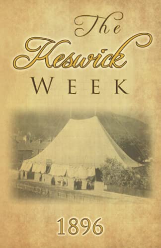
The Keswick Week 1896
Idioma: Inglés
Publicado por Independently published, 2019
ISBN 10: 1703368800 ISBN 13: 9781703368802
Librería: Revaluation Books, Exeter, Reino Unido
Calificación del vendedor: 5 de 5 estrellas
EUR 38,75
Envío por EUR 14,46
Se envía de Reino Unido a Estados Unidos de AmericaCantidad disponible: 1 disponibles
Ańadir al carritoPaperback. Condición: Brand New. 481 pages. 8.50x5.50x1.09 inches. In Stock.
-
An engraved antique map of Hertfordshire, England
Idioma: Inglés
Ańo de publicación: 1836
Librería: GN Books and Prints, Inverness, Reino Unido
Calificación del vendedor: 5 de 5 estrellas
Mapa
EUR 10,44
Envío por EUR 22,21
Se envía de Reino Unido a Estados Unidos de AmericaCantidad disponible: 1 disponibles
Ańadir al carritoNo Binding. Condición: As Described. No Jacket. Thomas Moule Ilustrador. An engraved antique map of Hertfordshire, England, by Thomas Moule, from a copy of "Barclay's Complete and Universal English Dictionary" by the Rev. James Barclay, published 1836-1848. Richly decorated, containing ornate border and a number of vignettes, including coats of arms and illustrations of St Albans Abbey and Cashiobury. Displays Reference to the Hundreds, with railway line and stations denoted. Measures around 10 3/4" x 8 1/2" (273mm x 215mm). The map contains no folds. There are signs of wear with a little tearing, binding holes and puckering at head edge. Considerable foxing and toning, especially to extremities, and minor other marking. See pictures for further information. 1836-1848. n.
-
An engraved antique map of Northumberland, England
Idioma: Inglés
Ańo de publicación: 1836
Librería: GN Books and Prints, Inverness, Reino Unido
Calificación del vendedor: 5 de 5 estrellas
Mapa
EUR 13,39
Envío por EUR 22,21
Se envía de Reino Unido a Estados Unidos de AmericaCantidad disponible: 1 disponibles
Ańadir al carritoNo Binding. Condición: As Described. No Jacket. Thomas Moule Ilustrador. An engraved antique map of Northumberland, England, by Thomas Moule, from a copy of "Barclay's Complete and Universal English Dictionary" by the Rev. James Barclay, published 1836-1848. Richly decorated, containing ornate border and a number of vignettes, including coats of arms and an illustration of Alnwick Castle. Displays Reference to the Wards, Parts of the County, Scale of Miles and railways lines and stations are denoted. Measures around 8 3/8" x 10 3/4" (214mm x 274mm). The map contains no folds. There are signs of wear with a little tearing and binding holes at right-hand edge and some creasing there. Some foxing and toning, mainly at extremities, and minor other marking but reasonably clean. Closely cropped at head and tail. See pictures for further information. 1836-1848. n.
-
An engraved antique map of Norfolk, England
Idioma: Inglés
Ańo de publicación: 1836
Librería: GN Books and Prints, Inverness, Reino Unido
Calificación del vendedor: 5 de 5 estrellas
Mapa
EUR 13,39
Envío por EUR 22,21
Se envía de Reino Unido a Estados Unidos de AmericaCantidad disponible: 1 disponibles
Ańadir al carritoNo Binding. Condición: As Described. No Jacket. Thomas Moule Ilustrador. An engraved antique map of Norfolk, England, by Thomas Moule, from a copy of "Barclay's Complete and Universal English Dictionary" by the Rev. James Barclay, published 1836-1848. Richly decorated, containing ornate border and a number of vignettes, including coats of arms and illustrations of Holkham Hall and Norwich Cathedral. Displays Reference to the Hundreds, with railway line and stations denoted. Measures around 10 7/8" x 8 1/2" (278mm x 217mm). The map contains no folds. There are signs of wear with a little tearing and some puckering at tail edge and some holes at head edge. Some foxing and toning, especially to extremities, and minor other marking. See pictures for further information. 1836-1848. n.
-
An engraved antique map of Surrey, England
Idioma: Inglés
Ańo de publicación: 1836
Librería: GN Books and Prints, Inverness, Reino Unido
Calificación del vendedor: 5 de 5 estrellas
Mapa
EUR 13,39
Envío por EUR 22,21
Se envía de Reino Unido a Estados Unidos de AmericaCantidad disponible: 1 disponibles
Ańadir al carritoNo Binding. Condición: As Described. No Jacket. Thomas Moule Ilustrador. An engraved antique map of Surrey, England, by Thomas Moule, from a copy of "Barclay's Complete and Universal English Dictionary" by the Rev. James Barclay, published 1836-1848. Richly decorated, containing ornate border and a number of vignettes, including coats of arms and illustrations of Dulwich College and Richmond Bridge. Displays Reference to the Hundreds and Scale of Miles. Measures around 10 3/4" x 8 1/2" (274mm x 217mm). The map contains no folds. There are signs of wear with a little tearing, binding holes and creasing at head edge and a little tearing at tail edge. Some loss to upper left edge. A little toning to extremities, and minor other marking but very clean. See pictures for further information. 1836-1848. n.
-
An engraved antique map of Worcestershire, England
Idioma: Inglés
Ańo de publicación: 1836
Librería: GN Books and Prints, Inverness, Reino Unido
Calificación del vendedor: 5 de 5 estrellas
Mapa
EUR 13,39
Envío por EUR 22,21
Se envía de Reino Unido a Estados Unidos de AmericaCantidad disponible: 1 disponibles
Ańadir al carritoNo Binding. Condición: As Described. No Jacket. Thomas Moule Ilustrador. An engraved antique map of Worcestershire, England, by Thomas Moule, from a copy of "Barclay's Complete and Universal English Dictionary" by the Rev. James Barclay, published 1836-1848. Richly decorated, containing ornate border and a number of vignettes, including coats of arms and illustrations of Great Malvern, Worcester and Croom Court. Displays Reference to the Hundreds with Scale of Miles. Measures around 8 1/2" x 10 7/8" (217mm x 278mm). The map contains no folds. There are signs of wear with some tearing and binding holes at left-hand edge and some creasing there. Foxing and toning, mainly at extremities, and minor other marking but otherwise quite clean. See pictures for further information. 1836-1848. n.
-
An engraved antique map of Cumberland, England
Idioma: Inglés
Ańo de publicación: 1836
Librería: GN Books and Prints, Inverness, Reino Unido
Calificación del vendedor: 5 de 5 estrellas
Mapa
EUR 13,39
Envío por EUR 22,21
Se envía de Reino Unido a Estados Unidos de AmericaCantidad disponible: 1 disponibles
Ańadir al carritoNo Binding. Condición: As Described. No Jacket. Thomas Moule Ilustrador. An engraved antique map of Cumberland, England, by Thomas Moule, from a copy of "Barclay's Complete and Universal English Dictionary" by the Rev. James Barclay, published 1836-1848. Richly decorated, containing ornate border and a number of vignettes, including coats of arms and illustration of Carlisle. Displays Reference to the Wards. Measures around 8 1/2" x 10 3/4" (215mm x 273mm). The map contains no folds. There are signs of wear with a little tearing, binding holes and puckering at left-hand edge. A little foxing and toning, predominantly at edges, and minor other marking but reasonably clean. See pictures for further information. 1836-1848. n.
-
An engraved antique map of Essex, England
Idioma: Inglés
Ańo de publicación: 1836
Librería: GN Books and Prints, Inverness, Reino Unido
Calificación del vendedor: 5 de 5 estrellas
Mapa
EUR 13,39
Envío por EUR 22,21
Se envía de Reino Unido a Estados Unidos de AmericaCantidad disponible: 1 disponibles
Ańadir al carritoNo Binding. Condición: As Described. No Jacket. Thomas Moule; William Schmollinger Ilustrador. An engraved antique map of Essex, England, by Thomas Moule, engraved by William Schmollinger, from a copy of "Barclay's Complete and Universal English Dictionary" by the Rev. James Barclay, published 1836-1848. Richly decorated, containing ornate border and a number of vignettes, including coats of arms and illustrations of Chelmsford and Southend. Displays Reference to the Hundreds and Scale of Miles, with railway lines and stations denoted. Measures around 10 3/4" x 8 1/2" (273mm x 215mm). The map contains no folds. There are signs of wear with a little tearing, binding holes and creasing at head edge. A little foxing and toning, mainly to extremities, and minor other marking. Some staining to bottom-left corner (more visible on verso, bottom-right). See pictures for further information. 1836-1848. n.
-
An engraved antique map of Huntingdonshire, England
Idioma: Inglés
Ańo de publicación: 1836
Librería: GN Books and Prints, Inverness, Reino Unido
Calificación del vendedor: 5 de 5 estrellas
Mapa
EUR 13,39
Envío por EUR 22,21
Se envía de Reino Unido a Estados Unidos de AmericaCantidad disponible: 1 disponibles
Ańadir al carritoNo Binding. Condición: As Described. No Jacket. Thomas Moule Ilustrador. An engraved antique map of Huntingdonshire, England, by Thomas Moule, from a copy of "Barclay's Complete and Universal English Dictionary" by the Rev. James Barclay, published 1836-1848. Richly decorated, containing ornate border and a number of vignettes, including coats of arms and illustrations of Hinchingbrook and Brampton Park. Displays Reference to the Hundreds with Scale of Miles and railway lines and stations denoted. Measures around 8 1/2" x 10 7/8" (215mm x 278mm). The map contains no folds. There are signs of wear with a little tearing, binding holes and puckering at right-hand edge. Some foxing and toning, predominantly at extremities, and minor other marking. See pictures for further information. 1836-1848. n.
-
An engraved antique map of Northamptonshire, England
Idioma: Inglés
Ańo de publicación: 1836
Librería: GN Books and Prints, Inverness, Reino Unido
Calificación del vendedor: 5 de 5 estrellas
Mapa
EUR 13,39
Envío por EUR 22,21
Se envía de Reino Unido a Estados Unidos de AmericaCantidad disponible: 1 disponibles
Ańadir al carritoNo Binding. Condición: As Described. No Jacket. Thomas Moule Ilustrador. An engraved antique map of Northamptonshire, England, by Thomas Moule, from a copy of "Barclay's Complete and Universal English Dictionary" by the Rev. James Barclay, published 1836-1848. Richly decorated, containing ornate border and a number of vignettes, including coats of arms and illustrations of Northampton, Althorpe House and Peterborough Cathedral. Displays Reference to the Hundreds with Scale of Miles and railways lines and stations denoted. Measures around 8 3/8" x 10 3/4" (214mm x 273mm). The map contains no folds. There are signs of wear with a little tearing and binding holes at right-hand edge and some creasing there. Some foxing and toning at extremities, and minor other marking but reasonably clean. See pictures for further information. 1836-1848. n.
-
An engraved antique map of Leicestershire, England
Idioma: Inglés
Ańo de publicación: 1836
Librería: GN Books and Prints, Inverness, Reino Unido
Calificación del vendedor: 5 de 5 estrellas
Mapa
EUR 13,39
Envío por EUR 22,21
Se envía de Reino Unido a Estados Unidos de AmericaCantidad disponible: 1 disponibles
Ańadir al carritoNo Binding. Condición: As Described. No Jacket. Thomas Moule Ilustrador. An engraved antique map of Leicestershire, England, by Thomas Moule, from a copy of "Barclay's Complete and Universal English Dictionary" by the Rev. James Barclay, published 1836-1848. Richly decorated, containing ornate border and a number of vignettes, including coats of arms and illustrations of Belvoir Castle, Ulverscroft Abbey and Donington Castle. Displays Reference to the Hundreds with Scale of Miles. Measures around 8 1/2" x 10 3/4" (217mm x 274mm). The map contains no folds. There are signs of wear with a little tearing and binding holes at right-hand edge. Light foxing and toning, predominantly at extremities, and minor other marking but reasonably clean. See pictures for further information. 1836-1848. n.
-
An engraved antique map of Nottinghamshire, England
Idioma: Inglés
Ańo de publicación: 1836
Librería: GN Books and Prints, Inverness, Reino Unido
Calificación del vendedor: 5 de 5 estrellas
Mapa
EUR 13,39
Envío por EUR 22,21
Se envía de Reino Unido a Estados Unidos de AmericaCantidad disponible: 1 disponibles
Ańadir al carritoNo Binding. Condición: As Described. No Jacket. Thomas Moule Ilustrador. An engraved antique map of Nottinghamshire, England, by Thomas Moule, from a copy of "Barclay's Complete and Universal English Dictionary" by the Rev. James Barclay, published 1836-1848. Richly decorated, containing ornate border and a number of vignettes, including coats of arms and illustrations of Worksop Manor, Nottingham Castle and Newstead Abbey. Displays Reference to the Hundreds with Scale of Miles, with railways lines and stations denoted. Measures around 8 3/8" x 10 3/4" (215mm x 273mm). The map contains no folds. There are signs of wear with a little tearing and binding holes at right-hand edge and some creasing there. Light foxing and toning at extremities, minor other marking but quite clean. See pictures for further information. 1836-1848. n.
-
An engraved antique map of Monmouthshire, England
Idioma: Inglés
Ańo de publicación: 1836
Librería: GN Books and Prints, Inverness, Reino Unido
Calificación del vendedor: 5 de 5 estrellas
Mapa
EUR 13,39
Envío por EUR 22,21
Se envía de Reino Unido a Estados Unidos de AmericaCantidad disponible: 1 disponibles
Ańadir al carritoNo Binding. Condición: As Described. No Jacket. Thomas Moule Ilustrador. An engraved antique map of Monmouthshire, Wales, by Thomas Moule, from a copy of "Barclay's Complete and Universal English Dictionary" by the Rev. James Barclay, published 1836-1848. Richly decorated, containing ornate border and a number of vignettes, including coats of arms and illustrations of Tintern Abbey, Chepstow Castle and Town Hall Monmouth. Displays Reference to the Hundreds with Scale of Miles. Measures around 8 1/2" x 10 7/8" (215mm x 278mm). The map contains no folds. There are signs of wear with a little tearing and binding holes at right-hand edge. Light foxing and heaving toning at extremities, and minor other marking but reasonably clean. See pictures for further information. 1836-1848. n.
-
An engraved antique map of Staffordshire, England
Idioma: Inglés
Ańo de publicación: 1836
Librería: GN Books and Prints, Inverness, Reino Unido
Calificación del vendedor: 5 de 5 estrellas
Mapa
EUR 13,39
Envío por EUR 22,21
Se envía de Reino Unido a Estados Unidos de AmericaCantidad disponible: 1 disponibles
Ańadir al carritoNo Binding. Condición: As Described. No Jacket. Thomas Moule Ilustrador. An engraved antique map of Staffordshire, England, by Thomas Moule, from a copy of "Barclay's Complete and Universal English Dictionary" by the Rev. James Barclay, published 1836-1848. Richly decorated, containing ornate border and a number of vignettes, including coats of arms and illustrations of Stafford Castle, Lichfield Cathedral and Ingestre House. Displays Reference to the Hundreds with Scale of Miles and railways lines and stations denoted. Measures around 8 1/2" x 10 3/4" (215mm x 273mm). The map contains no folds. There are signs of wear with a little tearing and binding holes at right-hand edge and some creasing there. Light foxing and toning at extremities, and minor other marking. Large stain to upper left corner. See pictures for further information. 1836-1848. n.
-
An engraved antique map of Warwickshire, England
Idioma: Inglés
Ańo de publicación: 1836
Librería: GN Books and Prints, Inverness, Reino Unido
Calificación del vendedor: 5 de 5 estrellas
Mapa
EUR 13,39
Envío por EUR 22,21
Se envía de Reino Unido a Estados Unidos de AmericaCantidad disponible: 1 disponibles
Ańadir al carritoNo Binding. Condición: As Described. No Jacket. Thomas Moule Ilustrador. An engraved antique map of Warwickshire, England, by Thomas Moule, from a copy of "Barclay's Complete and Universal English Dictionary" by the Rev. James Barclay, published 1836-1848. Richly decorated, containing ornate border and a number of vignettes, including coats of arms and illustrations of Warwick Castle and Kenilworth Castle. Displays Reference to the Hundreds with Scale of Miles. Measures around 8 1/2" x 10 7/8" (217mm x 278mm). The map contains no folds. There are signs of wear with a little tearing and binding holes at right-hand edge and some creasing there. Foxing and toning at extremities, and minor other marking but otherwise quite clean. See pictures for further information. 1836-1848. n.
-
An engraved antique map of Rutlandshire, England
Idioma: Inglés
Ańo de publicación: 1836
Librería: GN Books and Prints, Inverness, Reino Unido
Calificación del vendedor: 5 de 5 estrellas
Mapa
EUR 13,39
Envío por EUR 22,21
Se envía de Reino Unido a Estados Unidos de AmericaCantidad disponible: 1 disponibles
Ańadir al carritoNo Binding. Condición: As Described. No Jacket. Thomas Moule Ilustrador. An engraved antique map of Rutlandshire, England, by Thomas Moule, from a copy of "Barclay's Complete and Universal English Dictionary" by the Rev. James Barclay, published 1836-1848. Richly decorated, containing ornate border and a number of vignettes, including coats of arms and illustrations of Burley House, Normanton Park and Empingham. Displays Reference to the Hundreds and Scale of Miles. Measures around 8 3/8" x 10 3/4" (214mm x 275mm). The map contains no folds. There are signs of wear at edges and corners and some minor tearing. Light toning at extremities, minor other marking and a little staining to upper left corner. See pictures for further information. 1836-1848. n.
-
An engraved antique map of Westmorland, England
Idioma: Inglés
Ańo de publicación: 1836
Librería: GN Books and Prints, Inverness, Reino Unido
Calificación del vendedor: 5 de 5 estrellas
Mapa
EUR 13,39
Envío por EUR 22,21
Se envía de Reino Unido a Estados Unidos de AmericaCantidad disponible: 1 disponibles
Ańadir al carritoNo Binding. Condición: As Described. No Jacket. Thomas Moule Ilustrador. An engraved antique map of Westmorland, England, by Thomas Moule, from a copy of "Barclay's Complete and Universal English Dictionary" by the Rev. James Barclay, published 1836-1848. Richly decorated, containing ornate border and a number of vignettes, including coats of arms and illustrations of Brougham Hall and the Keep of Appleby Castle. Displays Reference to the Wards. Measures around 10 3/4" x 8 1/2" (274mm x 215mm). The map contains no folds. There are signs of wear with a little tearing, binding holes and creasing at head edge and a little tearing at tail edge. Some toning to extremities, and minor other marking but generally clean. See pictures for further information. 1836-1848. n.
-
An engraved antique map of Yorkshire East Riding, England
Idioma: Inglés
Ańo de publicación: 1836
Librería: GN Books and Prints, Inverness, Reino Unido
Calificación del vendedor: 5 de 5 estrellas
Mapa
EUR 13,39
Envío por EUR 22,21
Se envía de Reino Unido a Estados Unidos de AmericaCantidad disponible: 1 disponibles
Ańadir al carritoNo Binding. Condición: As Described. No Jacket. Thomas Moule Ilustrador. An engraved antique map of Yorkshire East Riding, England, by Thomas Moule, from a copy of "Barclay's Complete and Universal English Dictionary" by the Rev. James Barclay, published 1836-1848. Richly decorated, containing ornate border and a number of vignettes, including coats of arms and an illustration of Beverley Minster. Displays Reference to the Wards, as well as railway lines and stations denoted. Measures around 10 3/4" x 8 3/8" (274mm x 214mm). The map contains no folds. There are signs of wear with a little tearing, binding holes, a little loss and creasing at head edge. Some toning to extremities, foxing which is visible to verso but less to to rector, and minor other marking but generally clean. See pictures for further information. 1836-1848. n.
-
An engraved antique map of Durham, England
Idioma: Inglés
Ańo de publicación: 1836
Librería: GN Books and Prints, Inverness, Reino Unido
Calificación del vendedor: 5 de 5 estrellas
Mapa
EUR 13,39
Envío por EUR 22,21
Se envía de Reino Unido a Estados Unidos de AmericaCantidad disponible: 1 disponibles
Ańadir al carritoNo Binding. Condición: As Described. No Jacket. Thomas Moule; William Schmollinger Ilustrador. An engraved antique map of Durham, England, by Thomas Moule, engraved by William Schmollinger, from a copy of "Barclay's Complete and Universal English Dictionary" by the Rev. James Barclay, published 1836-1848. Richly decorated, containing ornate border and a number of vignettes, including coats of arms and illustrations of Durham and Raby Castle. Displays Reference to the Wards and Scale of Miles, with railway line and stations denoted. Measures around 10 3/4" x 8 1/2" (273mm x 215mm). The map contains no folds. There are signs of wear with a little tearing, binding holes and puckering at head edge. A little foxing and toning, mainly to extremities, and minor other marking but reasonably clean. See pictures for further information. 1836-1848. n.
-
An engraved antique map of Bedfordshire, England, by Thomas Moule
Idioma: Inglés
Ańo de publicación: 1836
Librería: GN Books and Prints, Inverness, Reino Unido
Calificación del vendedor: 5 de 5 estrellas
Mapa
EUR 13,39
Envío por EUR 22,21
Se envía de Reino Unido a Estados Unidos de AmericaCantidad disponible: 1 disponibles
Ańadir al carritoNo Binding. Condición: As Described. No Jacket. Thomas Moule Ilustrador. An engraved antique map of Bedfordshire, England, by Thomas Moule, from a copy of "Barclay's Complete and Universal English Dictionary" by the Rev. James Barclay, published 1836-1848. Richly decorated, containing ornate border and a number of vignettes, including coats of arms and illustrations of Dunstable Priory and Woburn Abbey. Displays Reference to the Hundreds. Measures around 8 1/2" x 10 5/8" (215mm x 272mm). The map contains no folds. There are signs of wear with a little tearing, binding holes and puckering at left-hand edge. A little foxing and toning, predominantly at edges, and minor other marking but reasonably clean. Cropped quite closely at tail margin. See pictures for further information. 1836-1848. n.
-
An engraved antique map of Herefordshire, England
Idioma: Inglés
Ańo de publicación: 1836
Librería: GN Books and Prints, Inverness, Reino Unido
Calificación del vendedor: 5 de 5 estrellas
Mapa
EUR 13,39
Envío por EUR 22,21
Se envía de Reino Unido a Estados Unidos de AmericaCantidad disponible: 1 disponibles
Ańadir al carritoNo Binding. Condición: As Described. No Jacket. Thomas Moule Ilustrador. An engraved antique map of Herefordshire, England, by Thomas Moule, from a copy of "Barclay's Complete and Universal English Dictionary" by the Rev. James Barclay, published 1836-1848. Richly decorated, containing ornate border and a number of vignettes, including coats of arms and illustrations of Goodrich castle, Garnstone House and Hereford. Displays Reference to the Hundreds. Measures around 8 1/2" x 10 3/4" (215mm x 273mm). The map contains no folds. There are signs of wear with a little tearing, binding holes and puckering at right-hand edge. A little foxing and toning, predominantly at edges, and minor other marking and some staining to bottom right-hand corner. See pictures for further information. 1836-1848. n.


