
Drawn thomas moule (29 resultados)
 Más imágenes
Idioma: Inglés
- Mapa
Librería: GN Books and Prints, Inverness, Reino UnidoGN Books and Prints
Contactar con el vendedorVendedor de 4 estrellasCondición: Usado
EUR 14,16
Envío por EUR 22,58Se envía de Reino Unido a Estados Unidos de AmericaCantidad disponible: 1 disponibles
No Binding. Condición: As Described. No Jacket. An antique engraved map of Wiltshire, England, engraved by James Bingley, from Thomas Moule's "English Counties Delineated" circa 1830s-1840s. Richly decorated, containing ornate border and a number of vignettes, including coats of arms and illustrations of Salisbury Cathedral and…Stonehenge. Displays Reference to the Hundreds. Measures around 8 1/2" x 10 5/8" (216mm x 271mm). The map contains no folds. There are signs of wear with a little tearing, binding holes and creasing at right-hand edge. Extensive foxing and toning, minor other marking. See pictures for further information. 1830s-1840s. Thomas Moule; I. Dower (ilustrador).
 Más imágenes
Idioma: Inglés
- Mapa
Librería: GN Books and Prints, Inverness, Reino UnidoGN Books and Prints
Contactar con el vendedorVendedor de 4 estrellasCondición: Usado
EUR 14,16
Envío por EUR 22,58Se envía de Reino Unido a Estados Unidos de AmericaCantidad disponible: 1 disponibles
No Binding. Condición: As Described. No Jacket. An engraved antique map of Hertfordshire, England, by Thomas Moule, from a copy of "Barclay's Complete and Universal English Dictionary" by the Rev. James Barclay, published 1836-1848. Richly decorated, containing ornate border and a number of vignettes, including coats of arms and… illustrations of St Albans Abbey and Cashiobury. Displays Reference to the Hundreds, with railway line and stations denoted. Measures around 10 3/4" x 8 1/2" (273mm x 215mm). The map contains no folds. There are signs of wear with a little tearing, binding holes and puckering at head edge. Considerable foxing and toning, especially to extremities, and minor other marking. See pictures for further information. 1836-1848. Thomas Moule (ilustrador).
 Más imágenes
Idioma: Inglés
- Mapa
Librería: GN Books and Prints, Inverness, Reino UnidoGN Books and Prints
Contactar con el vendedorVendedor de 4 estrellasCondición: Usado
EUR 18,16
Envío por EUR 22,58Se envía de Reino Unido a Estados Unidos de AmericaCantidad disponible: 1 disponibles
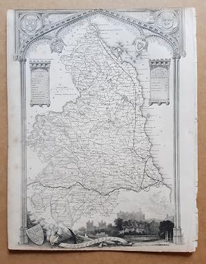
No Binding. Condición: As Described. No Jacket. An engraved antique map of Northumberland, England, by Thomas Moule, from a copy of "Barclay's Complete and Universal English Dictionary" by the Rev. James Barclay, published 1836-1848. Richly decorated, containing ornate border and a number of vignettes, including coats of arms an…d an illustration of Alnwick Castle. Displays Reference to the Wards, Parts of the County, Scale of Miles and railways lines and stations are denoted. Measures around 8 3/8" x 10 3/4" (214mm x 274mm). The map contains no folds. There are signs of wear with a little tearing and binding holes at right-hand edge and some creasing there. Some foxing and toning, mainly at extremities, and minor other marking but reasonably clean. Closely cropped at head and tail. See pictures for further information. 1836-1848. Thomas Moule (ilustrador).
 Más imágenes
Idioma: Inglés
- Mapa
Librería: GN Books and Prints, Inverness, Reino UnidoGN Books and Prints
Contactar con el vendedorVendedor de 4 estrellasCondición: Usado
EUR 18,16
Envío por EUR 22,58Se envía de Reino Unido a Estados Unidos de AmericaCantidad disponible: 1 disponibles
No Binding. Condición: As Described. No Jacket. An engraved antique map of Norfolk, England, by Thomas Moule, from a copy of "Barclay's Complete and Universal English Dictionary" by the Rev. James Barclay, published 1836-1848. Richly decorated, containing ornate border and a number of vignettes, including coats of arms and illus…trations of Holkham Hall and Norwich Cathedral. Displays Reference to the Hundreds, with railway line and stations denoted. Measures around 10 7/8" x 8 1/2" (278mm x 217mm). The map contains no folds. There are signs of wear with a little tearing and some puckering at tail edge and some holes at head edge. Some foxing and toning, especially to extremities, and minor other marking. See pictures for further information. 1836-1848. Thomas Moule (ilustrador).
 Más imágenes
Idioma: Inglés
- Mapa
Librería: GN Books and Prints, Inverness, Reino UnidoGN Books and Prints
Contactar con el vendedorVendedor de 4 estrellasCondición: Usado
EUR 18,16
Envío por EUR 22,58Se envía de Reino Unido a Estados Unidos de AmericaCantidad disponible: 1 disponibles
No Binding. Condición: As Described. No Jacket. An engraved antique map of Surrey, England, by Thomas Moule, from a copy of "Barclay's Complete and Universal English Dictionary" by the Rev. James Barclay, published 1836-1848. Richly decorated, containing ornate border and a number of vignettes, including coats of arms and illust…rations of Dulwich College and Richmond Bridge. Displays Reference to the Hundreds and Scale of Miles. Measures around 10 3/4" x 8 1/2" (274mm x 217mm). The map contains no folds. There are signs of wear with a little tearing, binding holes and creasing at head edge and a little tearing at tail edge. Some loss to upper left edge. A little toning to extremities, and minor other marking but very clean. See pictures for further information. 1836-1848. Thomas Moule (ilustrador).
 Más imágenes
Idioma: Inglés
- Mapa
Librería: GN Books and Prints, Inverness, Reino UnidoGN Books and Prints
Contactar con el vendedorVendedor de 4 estrellasCondición: Usado
EUR 18,16
Envío por EUR 22,58Se envía de Reino Unido a Estados Unidos de AmericaCantidad disponible: 1 disponibles
No Binding. Condición: As Described. No Jacket. An engraved antique map of Worcestershire, England, by Thomas Moule, from a copy of "Barclay's Complete and Universal English Dictionary" by the Rev. James Barclay, published 1836-1848. Richly decorated, containing ornate border and a number of vignettes, including coats of arms an…d illustrations of Great Malvern, Worcester and Croom Court. Displays Reference to the Hundreds with Scale of Miles. Measures around 8 1/2" x 10 7/8" (217mm x 278mm). The map contains no folds. There are signs of wear with some tearing and binding holes at left-hand edge and some creasing there. Foxing and toning, mainly at extremities, and minor other marking but otherwise quite clean. See pictures for further information. 1836-1848. Thomas Moule (ilustrador).
 Más imágenes
An engraved antique map of Essex, England
Rev. James Barclay; Drawn by Thomas Moule; Engraved by William Schmollinger
Idioma: Inglés
- Mapa
Librería: GN Books and Prints, Inverness, Reino UnidoGN Books and Prints
Contactar con el vendedorVendedor de 4 estrellasCondición: Usado
EUR 18,16
Envío por EUR 22,58Se envía de Reino Unido a Estados Unidos de AmericaCantidad disponible: 1 disponibles
No Binding. Condición: As Described. No Jacket. An engraved antique map of Essex, England, by Thomas Moule, engraved by William Schmollinger, from a copy of "Barclay's Complete and Universal English Dictionary" by the Rev. James Barclay, published 1836-1848. Richly decorated, containing ornate border and a number of vignettes, i…ncluding coats of arms and illustrations of Chelmsford and Southend. Displays Reference to the Hundreds and Scale of Miles, with railway lines and stations denoted. Measures around 10 3/4" x 8 1/2" (273mm x 215mm). The map contains no folds. There are signs of wear with a little tearing, binding holes and creasing at head edge. A little foxing and toning, mainly to extremities, and minor other marking. Some staining to bottom-left corner (more visible on verso, bottom-right). See pictures for further information. 1836-1848. Thomas Moule; William Schmollinger (ilustrador).
 Más imágenes
Idioma: Inglés
- Mapa
Librería: GN Books and Prints, Inverness, Reino UnidoGN Books and Prints
Contactar con el vendedorVendedor de 4 estrellasCondición: Usado
EUR 18,16
Envío por EUR 22,58Se envía de Reino Unido a Estados Unidos de AmericaCantidad disponible: 1 disponibles
No Binding. Condición: As Described. No Jacket. An engraved antique map of Northamptonshire, England, by Thomas Moule, from a copy of "Barclay's Complete and Universal English Dictionary" by the Rev. James Barclay, published 1836-1848. Richly decorated, containing ornate border and a number of vignettes, including coats of arms…and illustrations of Northampton, Althorpe House and Peterborough Cathedral. Displays Reference to the Hundreds with Scale of Miles and railways lines and stations denoted. Measures around 8 3/8" x 10 3/4" (214mm x 273mm). The map contains no folds. There are signs of wear with a little tearing and binding holes at right-hand edge and some creasing there. Some foxing and toning at extremities, and minor other marking but reasonably clean. See pictures for further information. 1836-1848. Thomas Moule (ilustrador).
 Más imágenes
Idioma: Inglés
- Mapa
Librería: GN Books and Prints, Inverness, Reino UnidoGN Books and Prints
Contactar con el vendedorVendedor de 4 estrellasCondición: Usado
EUR 18,16
Envío por EUR 22,58Se envía de Reino Unido a Estados Unidos de AmericaCantidad disponible: 1 disponibles
No Binding. Condición: As Described. No Jacket. An engraved antique map of Leicestershire, England, by Thomas Moule, from a copy of "Barclay's Complete and Universal English Dictionary" by the Rev. James Barclay, published 1836-1848. Richly decorated, containing ornate border and a number of vignettes, including coats of arms an…d illustrations of Belvoir Castle, Ulverscroft Abbey and Donington Castle. Displays Reference to the Hundreds with Scale of Miles. Measures around 8 1/2" x 10 3/4" (217mm x 274mm). The map contains no folds. There are signs of wear with a little tearing and binding holes at right-hand edge. Light foxing and toning, predominantly at extremities, and minor other marking but reasonably clean. See pictures for further information. 1836-1848. Thomas Moule (ilustrador).
 Más imágenes
Idioma: Inglés
- Mapa
Librería: GN Books and Prints, Inverness, Reino UnidoGN Books and Prints
Contactar con el vendedorVendedor de 4 estrellasCondición: Usado
EUR 18,16
Envío por EUR 22,58Se envía de Reino Unido a Estados Unidos de AmericaCantidad disponible: 1 disponibles
No Binding. Condición: As Described. No Jacket. An engraved antique map of Nottinghamshire, England, by Thomas Moule, from a copy of "Barclay's Complete and Universal English Dictionary" by the Rev. James Barclay, published 1836-1848. Richly decorated, containing ornate border and a number of vignettes, including coats of arms a…nd illustrations of Worksop Manor, Nottingham Castle and Newstead Abbey. Displays Reference to the Hundreds with Scale of Miles, with railways lines and stations denoted. Measures around 8 3/8" x 10 3/4" (215mm x 273mm). The map contains no folds. There are signs of wear with a little tearing and binding holes at right-hand edge and some creasing there. Light foxing and toning at extremities, minor other marking but quite clean. See pictures for further information. 1836-1848. Thomas Moule (ilustrador).
 Más imágenes
Idioma: Inglés
- Mapa
Librería: GN Books and Prints, Inverness, Reino UnidoGN Books and Prints
Contactar con el vendedorVendedor de 4 estrellasCondición: Usado
EUR 18,16
Envío por EUR 22,58Se envía de Reino Unido a Estados Unidos de AmericaCantidad disponible: 1 disponibles
No Binding. Condición: As Described. No Jacket. An engraved antique map of Monmouthshire, Wales, by Thomas Moule, from a copy of "Barclay's Complete and Universal English Dictionary" by the Rev. James Barclay, published 1836-1848. Richly decorated, containing ornate border and a number of vignettes, including coats of arms and i…llustrations of Tintern Abbey, Chepstow Castle and Town Hall Monmouth. Displays Reference to the Hundreds with Scale of Miles. Measures around 8 1/2" x 10 7/8" (215mm x 278mm). The map contains no folds. There are signs of wear with a little tearing and binding holes at right-hand edge. Light foxing and heaving toning at extremities, and minor other marking but reasonably clean. See pictures for further information. 1836-1848. Thomas Moule (ilustrador).
 Más imágenes
Idioma: Inglés
- Mapa
Librería: GN Books and Prints, Inverness, Reino UnidoGN Books and Prints
Contactar con el vendedorVendedor de 4 estrellasCondición: Usado
EUR 18,16
Envío por EUR 22,58Se envía de Reino Unido a Estados Unidos de AmericaCantidad disponible: 1 disponibles
No Binding. Condición: As Described. No Jacket. An engraved antique map of Staffordshire, England, by Thomas Moule, from a copy of "Barclay's Complete and Universal English Dictionary" by the Rev. James Barclay, published 1836-1848. Richly decorated, containing ornate border and a number of vignettes, including coats of arms and… illustrations of Stafford Castle, Lichfield Cathedral and Ingestre House. Displays Reference to the Hundreds with Scale of Miles and railways lines and stations denoted. Measures around 8 1/2" x 10 3/4" (215mm x 273mm). The map contains no folds. There are signs of wear with a little tearing and binding holes at right-hand edge and some creasing there. Light foxing and toning at extremities, and minor other marking. Large stain to upper left corner. See pictures for further information. 1836-1848. Thomas Moule (ilustrador).
 Más imágenes
Idioma: Inglés
- Mapa
Librería: GN Books and Prints, Inverness, Reino UnidoGN Books and Prints
Contactar con el vendedorVendedor de 4 estrellasCondición: Usado
EUR 18,16
Envío por EUR 22,58Se envía de Reino Unido a Estados Unidos de AmericaCantidad disponible: 1 disponibles
No Binding. Condición: As Described. No Jacket. An engraved antique map of Warwickshire, England, by Thomas Moule, from a copy of "Barclay's Complete and Universal English Dictionary" by the Rev. James Barclay, published 1836-1848. Richly decorated, containing ornate border and a number of vignettes, including coats of arms and…illustrations of Warwick Castle and Kenilworth Castle. Displays Reference to the Hundreds with Scale of Miles. Measures around 8 1/2" x 10 7/8" (217mm x 278mm). The map contains no folds. There are signs of wear with a little tearing and binding holes at right-hand edge and some creasing there. Foxing and toning at extremities, and minor other marking but otherwise quite clean. See pictures for further information. 1836-1848. Thomas Moule (ilustrador).
 Más imágenes
Idioma: Inglés
- Mapa
Librería: GN Books and Prints, Inverness, Reino UnidoGN Books and Prints
Contactar con el vendedorVendedor de 4 estrellasCondición: Usado
EUR 18,16
Envío por EUR 22,58Se envía de Reino Unido a Estados Unidos de AmericaCantidad disponible: 1 disponibles
No Binding. Condición: As Described. No Jacket. An engraved antique map of Rutlandshire, England, by Thomas Moule, from a copy of "Barclay's Complete and Universal English Dictionary" by the Rev. James Barclay, published 1836-1848. Richly decorated, containing ornate border and a number of vignettes, including coats of arms and…illustrations of Burley House, Normanton Park and Empingham. Displays Reference to the Hundreds and Scale of Miles. Measures around 8 3/8" x 10 3/4" (214mm x 275mm). The map contains no folds. There are signs of wear at edges and corners and some minor tearing. Light toning at extremities, minor other marking and a little staining to upper left corner. See pictures for further information. 1836-1848. Thomas Moule (ilustrador).
 Más imágenes
Idioma: Inglés
- Mapa
Librería: GN Books and Prints, Inverness, Reino UnidoGN Books and Prints
Contactar con el vendedorVendedor de 4 estrellasCondición: Usado
EUR 18,16
Envío por EUR 22,58Se envía de Reino Unido a Estados Unidos de AmericaCantidad disponible: 1 disponibles
No Binding. Condición: As Described. No Jacket. An engraved antique map of Westmorland, England, by Thomas Moule, from a copy of "Barclay's Complete and Universal English Dictionary" by the Rev. James Barclay, published 1836-1848. Richly decorated, containing ornate border and a number of vignettes, including coats of arms and i…llustrations of Brougham Hall and the Keep of Appleby Castle. Displays Reference to the Wards. Measures around 10 3/4" x 8 1/2" (274mm x 215mm). The map contains no folds. There are signs of wear with a little tearing, binding holes and creasing at head edge and a little tearing at tail edge. Some toning to extremities, and minor other marking but generally clean. See pictures for further information. 1836-1848. Thomas Moule (ilustrador).
 Más imágenes
Idioma: Inglés
- Mapa
Librería: GN Books and Prints, Inverness, Reino UnidoGN Books and Prints
Contactar con el vendedorVendedor de 4 estrellasCondición: Usado
EUR 18,16
Envío por EUR 22,58Se envía de Reino Unido a Estados Unidos de AmericaCantidad disponible: 1 disponibles
No Binding. Condición: As Described. No Jacket. An engraved antique map of Yorkshire East Riding, England, by Thomas Moule, from a copy of "Barclay's Complete and Universal English Dictionary" by the Rev. James Barclay, published 1836-1848. Richly decorated, containing ornate border and a number of vignettes, including coats of…arms and an illustration of Beverley Minster. Displays Reference to the Wards, as well as railway lines and stations denoted. Measures around 10 3/4" x 8 3/8" (274mm x 214mm). The map contains no folds. There are signs of wear with a little tearing, binding holes, a little loss and creasing at head edge. Some toning to extremities, foxing which is visible to verso but less to to rector, and minor other marking but generally clean. See pictures for further information. 1836-1848. Thomas Moule (ilustrador).
 Más imágenes
An engraved antique map of Durham, England
Rev. James Barclay; Drawn by Thomas Moule; Engraved by William Schmollinger
Idioma: Inglés
- Mapa
Librería: GN Books and Prints, Inverness, Reino UnidoGN Books and Prints
Contactar con el vendedorVendedor de 4 estrellasCondición: Usado
EUR 18,16
Envío por EUR 22,58Se envía de Reino Unido a Estados Unidos de AmericaCantidad disponible: 1 disponibles
No Binding. Condición: As Described. No Jacket. An engraved antique map of Durham, England, by Thomas Moule, engraved by William Schmollinger, from a copy of "Barclay's Complete and Universal English Dictionary" by the Rev. James Barclay, published 1836-1848. Richly decorated, containing ornate border and a number of vignettes,…including coats of arms and illustrations of Durham and Raby Castle. Displays Reference to the Wards and Scale of Miles, with railway line and stations denoted. Measures around 10 3/4" x 8 1/2" (273mm x 215mm). The map contains no folds. There are signs of wear with a little tearing, binding holes and puckering at head edge. A little foxing and toning, mainly to extremities, and minor other marking but reasonably clean. See pictures for further information. 1836-1848. Thomas Moule; William Schmollinger (ilustrador).
 Más imágenes
Idioma: Inglés
- Mapa
Librería: GN Books and Prints, Inverness, Reino UnidoGN Books and Prints
Contactar con el vendedorVendedor de 4 estrellasCondición: Usado
EUR 18,16
Envío por EUR 22,58Se envía de Reino Unido a Estados Unidos de AmericaCantidad disponible: 1 disponibles
No Binding. Condición: As Described. No Jacket. An engraved antique map of Buckinghamshire, England, by Thomas Moule, engraved by W. Schmollinger, from a copy of Moule's "English Counties Delineated", published circa 1830s-1840s. Richly decorated, containing ornate border and a number of vignettes, including coats of arms and an… illustration of Eton College. Displays Reference to the Hundreds. Measures around 8 1/2" x 10 5/8" (215mm x 271mm). The map contains no folds. There are signs of wear with a little tearing, binding holes and puckering at right-hand edge. A little foxing and toning, predominantly at edges, and minor other marking but reasonably clean. Cropped quite closely at head and tail margins, minor loss to border at head. See pictures for further information. 1830s-1840s. Thomas Moule; W. Schmollinger (ilustrador).
 Más imágenes
Idioma: Inglés
- Mapa
Librería: GN Books and Prints, Inverness, Reino UnidoGN Books and Prints
Contactar con el vendedorVendedor de 4 estrellasCondición: Usado
EUR 18,16
Envío por EUR 22,58Se envía de Reino Unido a Estados Unidos de AmericaCantidad disponible: 1 disponibles
No Binding. Condición: As Described. No Jacket. An engraved antique map of Herefordshire, England, by Thomas Moule, from a copy of "Barclay's Complete and Universal English Dictionary" by the Rev. James Barclay, published 1836-1848. Richly decorated, containing ornate border and a number of vignettes, including coats of arms and… illustrations of Goodrich castle, Garnstone House and Hereford. Displays Reference to the Hundreds. Measures around 8 1/2" x 10 3/4" (215mm x 273mm). The map contains no folds. There are signs of wear with a little tearing, binding holes and puckering at right-hand edge. A little foxing and toning, predominantly at edges, and minor other marking and some staining to bottom right-hand corner. See pictures for further information. 1836-1848. Thomas Moule (ilustrador).
 Más imágenes
An engraved antique map of Cumberland, England
Rev. James Barclay; Drawn by Thomas Moule; Engraved by William Schmollinger
Idioma: Inglés
- Mapa
Librería: GN Books and Prints, Inverness, Reino UnidoGN Books and Prints
Contactar con el vendedorVendedor de 4 estrellasCondición: Usado
EUR 18,16
Envío por EUR 22,58Se envía de Reino Unido a Estados Unidos de AmericaCantidad disponible: 1 disponibles
No Binding. Condición: As Described. No Jacket. An engraved antique map of Dorsetshire, England, by Thomas Moule, possibly engraved by William Schmollinger, from a copy of "Barclay's Complete and Universal English Dictionary" by the Rev. James Barclay, published 1836-1848. Richly decorated, containing ornate border and a number…of vignettes, including coats of arms and illustration of Shaftesbury. Displays Reference to the Hundreds and Liberties. Measures around 10 5/8" x 8 1/2" (271mm x 215mm). The map contains no folds. There are signs of wear with a little tearing, binding holes and puckering at tail edge. A little foxing and toning, and minor other marking but reasonably clean. See pictures for further information. 1836-1848. Thomas Moule; William Schmollinger (ilustrador).
 Más imágenes
Idioma: Inglés
- Mapa
Librería: GN Books and Prints, Inverness, Reino UnidoGN Books and Prints
Contactar con el vendedorVendedor de 4 estrellasCondición: Usado
EUR 18,16
Envío por EUR 22,58Se envía de Reino Unido a Estados Unidos de AmericaCantidad disponible: 1 disponibles
No Binding. Condición: As Described. No Jacket. An engraved antique map of Huntingdonshire, England, by Thomas Moule, from a copy of "Barclay's Complete and Universal English Dictionary" by the Rev. James Barclay, published 1836-1848. Richly decorated, containing ornate border and a number of vignettes, including coats of arms a…nd illustrations of Hinchingbrook and Brampton Park. Displays Reference to the Hundreds with Scale of Miles and railway lines and stations denoted. Measures around 8 1/2" x 10 7/8" (215mm x 278mm). The map contains no folds. There are signs of wear with a little tearing, binding holes and puckering at right-hand edge. Some foxing and toning, predominantly at extremities, and minor other marking. See pictures for further information. 1836-1848. Thomas Moule (ilustrador).
 Más imágenes
Idioma: Inglés
- Mapa
Librería: GN Books and Prints, Inverness, Reino UnidoGN Books and Prints
Contactar con el vendedorVendedor de 4 estrellasCondición: Usado
EUR 19,37
Envío por EUR 22,58Se envía de Reino Unido a Estados Unidos de AmericaCantidad disponible: 1 disponibles
No Binding. Condición: As Described. No Jacket. An engraved antique map of Northamptonshire, England, by Thomas Moule, from a copy of "Barclay's Complete and Universal English Dictionary" by the Rev. James Barclay, published 1836-1848. Light hand-colouring to title, parks and county boundary. Richly decorated, containing ornate…border and a number of vignettes, including coats of arms and illustrations of Northampton, Althorpe House and Peterborough Cathedral. Displays Reference to the Hundreds with Scale of Miles and railways lines and stations denoted. Measures around 8 3/8" x 10 3/4" (214mm x 273mm). The map contains no folds. There are signs of wear with at edges and a little tearing. Light marking but very clean for age. See pictures for further information. 1836-1848. Thomas Moule (ilustrador).
 Más imágenes
An engraved antique map of a Plan of Boston, Lincolnshire, England
Rev. James Barclay; Drawn by Thomas Moule; Engraved by James Bingley (possibly)
Idioma: Inglés
- Mapa
Librería: GN Books and Prints, Inverness, Reino UnidoGN Books and Prints
Contactar con el vendedorVendedor de 4 estrellasCondición: Usado
EUR 20,58
Envío por EUR 22,58Se envía de Reino Unido a Estados Unidos de AmericaCantidad disponible: 1 disponibles
No Binding. Condición: As Described. No Jacket. An engraved antique map of a Plan of Boston, Lincolnshire, England, by Thomas Moule, possibly engraved by James Bingley, taken either from a copy of "Barclay's Complete and Universal English Dictionary" by the Rev. James Barclay, first published 1836, or Smollett's History of Engla…nd, circa 1848. Richly decorated, containing ornate border and a number of vignettes, including coats of arms and illustrations of Louth Church, the Church and Bridge Boston, and Nocton House. Displays Scale of Chains. Measures around 8 1/2" x 10 3/4" (215mm x 273mm). The map contains no folds. There are signs of wear with some tearing and a little loss at right-hand edge, with a few binding piercing holes and a little puckering. A little foxing and toning, predominantly at edges, and minor other marking but reasonably clean. See pictures for further information. 1836-1848. Thomas Moule; James Bingley (ilustrador).
 Más imágenes
Idioma: Inglés
- Mapa
Librería: GN Books and Prints, Inverness, Reino UnidoGN Books and Prints
Contactar con el vendedorVendedor de 4 estrellasCondición: Usado
EUR 20,58
Envío por EUR 22,58Se envía de Reino Unido a Estados Unidos de AmericaCantidad disponible: 1 disponibles
No Binding. Condición: As Described. No Jacket. An engraved antique map of Norfolk, England, by Thomas Moule, from a copy of "Barclay's Complete and Universal English Dictionary" by the Rev. James Barclay, published 1836-1848. Some hand-colouring. Richly decorated, containing ornate border and a number of vignettes, including co…ats of arms and illustrations of Holkham Hall and Norwich Cathedral. Displays Reference to the Hundreds, with railway line and stations denoted. Measures around 9 3/4" x 8" (249mm x 202mm). The map contains no folds. There are signs of wear with a little tearing and some puckering at tail edge and some holes at head edge. Some foxing and toning, especially to extremities, and minor other marking. Closely cropped at edges, some detail missing from borders and several coats of arms. See pictures for further information. 1836-1848. Thomas Moule (ilustrador).
 Más imágenes
Idioma: Inglés
- Mapa
Librería: GN Books and Prints, Inverness, Reino UnidoGN Books and Prints
Contactar con el vendedorVendedor de 4 estrellasCondición: Usado
EUR 20,58
Envío por EUR 22,58Se envía de Reino Unido a Estados Unidos de AmericaCantidad disponible: 1 disponibles
No Binding. Condición: As Described. No Jacket. An antique engraved map of the Isle of Thanet, Kent, England, engraved by I. Dower from Thomas Moule's "English Counties Delineated" circa 1830s-1840s. Contains vignettes, comprising two coats of arms and illustrations of Ramsgate Harbour and North Foreland Light House, together wi…th a scale of English Miles. also title vignette with Latin inscription beneath title. Measures around 10 5/8 x 8 1/2" (270mm x 215mm). The map contains no folds. There are signs of wear with a little tearing at lower edge and a few binding piercing holes, and a little puckering. Some light foxing and toning, with a little other marking. Marking and offsetting to verso. Cropped quite close at right-hand margin and very close at upper margin whereby margin and border are missing. See pictures for further information. 1830s-1840s. Thomas Moule; I. Dower (ilustrador).
 Más imágenes
An antique map of Dorsetshire, England, drawn and engraved by William Schmollinger, from Thomas Moule's "The English Counties. A Topographical Description of England"
Drawn and engraved by William Schmollinger; book by Thomas Moule
Idioma: Inglés
- Mapa
Librería: GN Books and Prints, Inverness, Reino UnidoGN Books and Prints
Contactar con el vendedorVendedor de 4 estrellasCondición: Usado
EUR 20,58
Envío por EUR 22,58Se envía de Reino Unido a Estados Unidos de AmericaCantidad disponible: 1 disponibles
No Binding. Condición: As Described. No Jacket. An antique map of Dorsetshire, England, drawn and engraved by William Schmollinger, from Thomas Moule's "The English Counties A Topographical Description of England", published 1830s-1840s. Measures around 10 3/4" x 8 3/8" (272mm x 212mm). Contains decorative border, coats of arms,… illustration of Shaftesbury, and reference to the hundreds. No folds. Hand-colouring of county boundaries, border, title, illustrations, parks and crossroads. There are signs of wear, a little bumping to corners, a few small holes to upper edge, some holes and a little loss through tearing to bottom edge caused by removal from binding. A little light marking, a little pencil lettering to rear and some bleed through of colour, but overall very clean for age. Small pieces of binding tape on rear See pictures for further information. William Schmollinger (ilustrador).
 Más imágenes
An antique map of Herefordshire, England, drawn and engraved by William Schmollinger, from Thomas Moule's "The English Counties. A Topographical Description of England"
Drawn and engraved by William Schmollinger; book by Thomas Moule
Idioma: Inglés
- Mapa
Librería: GN Books and Prints, Inverness, Reino UnidoGN Books and Prints
Contactar con el vendedorVendedor de 4 estrellasCondición: Usado
EUR 20,58
Envío por EUR 22,58Se envía de Reino Unido a Estados Unidos de AmericaCantidad disponible: 1 disponibles
No Binding. Condición: As Described. No Jacket. An antique map of Herefordshire, England, drawn and engraved by William Schmollinger, from Thomas Moule's "The English Counties A Topographical Description of England", published 1830s-1840s Measures around 8 3/8" x 10 3/4" (212mm x 272mm). Contains decorative border, coats of arms…, illustrations of Goodrich Castle, Garnstone House and Hereford, and reference to the hundreds. No folds Hand-colouring of county boundaries, border, title, illustrations, parks and crossroads. There are signs of wear, though no loss except a few small holes to left-hand edge, some holes, small tears and creasing to right-hand edge caused by binding. A little light marking and light pencil writing in left-hand margin. A little pencil lettering to rear and some bleed through of colouring, but overall very clean for age. Rear contains small pieces of binding tape at edges. See pictures for further information. William Schmollinger (ilustrador).
 Más imágenes
An antique map of Wiltshire County, England, drawn and engraved by William Schmollinger, from Thomas Moule's "The English Counties. A Topographical Description of England"
Drawn and engraved by William Schmollinger; book by Thomas Moule
Idioma: Inglés
- Mapa
Librería: GN Books and Prints, Inverness, Reino UnidoGN Books and Prints
Contactar con el vendedorVendedor de 4 estrellasCondición: Usado
EUR 20,58
Envío por EUR 22,58Se envía de Reino Unido a Estados Unidos de AmericaCantidad disponible: 1 disponibles
No Binding. Condición: As Described. No Jacket. An antique map of Wiltshire, England, drawn and engraved by William Schmollinger, from Thomas Moule's "The English Counties A Topographical Description of England", published 1830s-1840s Measures around 8 3/8" x 10 3/4" (212mm x 272mm) Contains decorative border, coats of arms, ill…ustrations of Salisbury Cathedral and Stonehenge, and reference to the hundreds No folds Hand-colouring of county boundaries, boarder, title, illustrations, parks and crossroads There are signs of wear, though no loss except a couple of small holes to left-hand edge, caused by binding A little light marking, a little pencil lettering to rear but overall very clean for age Small pieces of binding tape See pictures for further information 1 pp Circa 1830s-1840s. William Schmollinger (ilustrador).
 Más imágenes
Idioma: Inglés
- Mapa
Librería: GN Books and Prints, Inverness, Reino UnidoGN Books and Prints
Contactar con el vendedorVendedor de 4 estrellasCondición: Usado
EUR 21,79
Envío por EUR 22,58Se envía de Reino Unido a Estados Unidos de AmericaCantidad disponible: 1 disponibles
No Binding. Condición: As Described. No Jacket. An antique engraved map of Monmouthshire, Wales, engraved by James Bingley, from Thomas Moule's "English Counties Delineated" circa 1830s-1840s. Hand-coloured. Richly decorated, containing ornate border and a number of vignettes, including coats of arms and illustrations of Tintern… Abbey, Chepstow Castle and Town Hall Monmouth. Displays Reference to the Hundreds and Scale of Miles. Measures around 8 1/2" x 10 5/8" (215mm x 270mm). The map contains no folds. There are signs of wear with a little tearing, binding holes and puckering at right-hand edge and a little unevenly cut on left-hand edge. Very light foxing and minor other marking but quite clean for age. Quite closely cropped at upper edge. See pictures for further information. 1830s-1840s. Thomas Moule; James Bingley (ilustrador).


