Ordnance survey map (110 resultados)

Idioma: Inglés
Editorial: Published for Isle of Wight Ramblers for Island Tourist Products Ltd 2015
- Tapa blanda
Librería: WeBuyBooks, Rossendale, LANCS, Reino UnidoWeBuyBooks
Contactar con el vendedorVendedor de 5 estrellasCondición: Usado - Aceptable
EUR 4,95
Envío por EUR 5,12Se envía de Reino Unido a Estados Unidos de AmericaCantidad disponible: 1 disponibles
Condición: Good. Most items will be dispatched the same or the next working day. A copy that has been read but remains in clean condition. All of the pages are intact and the cover is intact and the spine may show signs of wear. The book may have minor markings which are not specifically mentioned. All Maps In This Booklet Are S…ketched From The Ordnance Survey Map Outdoor Leisure 29 (ilustrador).

- Tapa blanda
Librería: WorldofBooks, Goring-By-Sea, WS, Reino UnidoWorldofBooks
Contactar con el vendedorVendedor de 5 estrellasCondición: Usado - Bueno
EUR 5,40
Envío por EUR 6,49Se envía de Reino Unido a Estados Unidos de AmericaCantidad disponible: 1 disponibles
Paperback. Condición: Very Good. The book has been read, but is in excellent condition. Pages are intact and not marred by notes or highlighting. The spine remains undamaged.
Idioma: Inglés
Editorial: Published for Isle of Wight Ramblers for Island Tourist Products Ltd 2015
- Tapa blanda
Librería: WorldofBooks, Goring-By-Sea, WS, Reino UnidoWorldofBooks
Contactar con el vendedorVendedor de 5 estrellasCondición: Usado - Bueno
EUR 7,90
Envío por EUR 6,49Se envía de Reino Unido a Estados Unidos de AmericaCantidad disponible: 1 disponibles
Paperback. Condición: Very Good. The book has been read, but is in excellent condition. Pages are intact and not marred by notes or highlighting. The spine remains undamaged. All Maps In This Booklet Are Sketched From The Ordnance Survey Map Outdoor Leisure 29 (ilustrador).

Idioma: Inglés
Editorial: Cassini Publishing Limited. Southampton, Hampshire. 2007 2007
- Primera edición
Librería: Coch-y-Bonddu Books Ltd, MACHYNLLETH, Reino UnidoCoch-y-Bonddu Books Ltd
Contactar con el vendedorVendedor de 5 estrellasMiembro de asociación: PBFA
Condición: Nuevo
EUR 1,14
Envío por EUR 11,59Se envía de Reino Unido a Estados Unidos de AmericaCantidad disponible: 5 disponibles
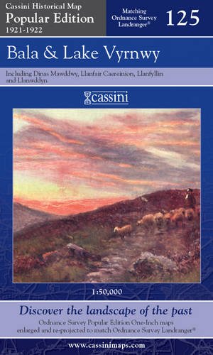
Condición: new. ALL UK PARCELS SENT TRACKED! ALL OVERSEAS PARCELS SENT AIRMAIL, TRACKED! (New, Map, 2007). (1921) 2007 1st edition thus. Folding map in blue card covers. This map includes Llanfair Caereinion, Dinas Mawddwy, Llanuwcllyn, Bala, Llanfyllin, Llangynog and Corwen. Fine new copy. The Cassini Popular Edition series pro…vides a fascinating snapshot of the human geography of Britain in the period between the two world wars. These maps are taken from the Ordnance Survey One-Inch 'Popular Edition' sheets, surveyed between 1921 and 1922. The original series of maps were 1" to the mile, and surveyed on a grid different from that employed today. In this new series, however, the 1" maps have been reprojected onto the OS National Grid so that all the edges match up. This makes the whole country into one single sheet from which positions can be read off in National Grid Numbers. This single sheet has been redivided, creating new sheets each corresponding precisely to a current Landranger map. The scale is now larger, at 1:50,000. This new series is uniquely useful for exploring the land and accurately pin-pointing where things are, or used to be. Equally useful for comparisons with current maps on the kitchen table. Much to be recommended. PREVIOUS PRICE GBP 9.99.
Idioma: Inglés
Editorial: Cassini Publishing Limited. Southampton, Hampshire. 2007 2007
- Primera edición
Librería: Coch-y-Bonddu Books Ltd, MACHYNLLETH, Reino UnidoCoch-y-Bonddu Books Ltd
Contactar con el vendedorVendedor de 5 estrellasMiembro de asociación: PBFA
Condición: Nuevo
EUR 1,14
Envío por EUR 11,59Se envía de Reino Unido a Estados Unidos de AmericaCantidad disponible: 1 disponibles
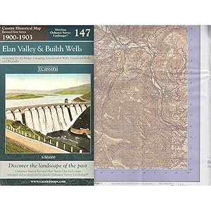
Condición: new. ALL UK PARCELS SENT TRACKED! ALL OVERSEAS PARCELS SENT AIRMAIL, TRACKED! (New, Map, 2007). (1903) 2007 1st edition thus. Folding map in green-blue card covers. This map includes the Elan Valley, Builth Wells, Devil's Bridge, Llangurig, Llandrindod Wells, Llanwrtyd Wells and Rhayader. Fine new copy. The Cassini Re…vised New Series provides a fascinating snapshot of the human geography of Britain at the turn of the twentieth century. These maps are taken from the Ordnance Survey One-Inch 'Revised New Series'sheets, surveyed between 1900 and 1903. The original series of maps were 1" to the mile, and surveyed on a grid different from that employed today. In this new series, however, the 1" maps have been reprojected onto the OS National Grid so that all the edges match up. This makes the whole country into one single sheet from which positions can be read off in National Grid numbers. This single sheet has been redivided, creating new sheets each corresponding precisely to a current Landranger map. The scale is now larger, at 1:50,000. This new series is uniquely useful for exploring the land and accurately pin-pointing where things are, or used to be. Equally useful for comparisons with current maps on the kitchen table. Much to be recommended. PREVIOUS PRICE GBP 6.99.
Idioma: Inglés
Editorial: Cassini Publishing Limited. Southampton, Hampshire. 2007 2007
- Primera edición
Librería: Coch-y-Bonddu Books Ltd, MACHYNLLETH, Reino UnidoCoch-y-Bonddu Books Ltd
Contactar con el vendedorVendedor de 5 estrellasMiembro de asociación: PBFA
Condición: Nuevo
EUR 1,14
Envío por EUR 11,59Se envía de Reino Unido a Estados Unidos de AmericaCantidad disponible: 1 disponibles
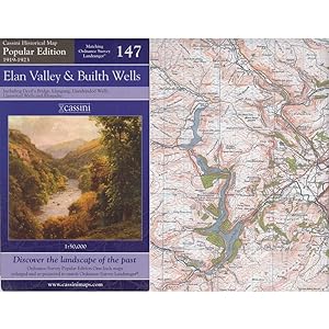
Condición: new. ALL UK PARCELS SENT TRACKED! ALL OVERSEAS PARCELS SENT AIRMAIL, TRACKED! (New, Map, 2007). (1923) 2007 1st edition thus. Folding map in blue card covers. This map includes the Elan Valley, Builth Wells, Devil's Bridge, Llangurig, Llandrindod Wells, Llanwrtyd Wells and Rhayader. Fine new copy. The Cassini Popular…Edition series provides a fascinating snapshot of the human geography of Britain in the period between the two world wars. These maps are taken from the Ordnance Survey One-Inch 'Popular Edition' sheets, surveyed between 1919 and 1923. The original series of maps were 1" to the mile, and surveyed on a grid different from that employed today. In this new series, however, the 1" maps have been reprojected onto the OS National Grid so that all the edges match up. This makes the whole country into one single sheet from which positions can be read off in National Grid Numbers. This single sheet has been redivided, creating new sheets each corresponding precisely to a current Landranger map. The scale is now larger, at 1:50,000. This new series is uniquely useful for exploring the land and accurately pin-pointing where things are, or used to be. Uniquely useful for comparisons with current maps on the kitchen table too. Much to be recommended. PREVIOUS PRICE GBP 6.99.

Idioma: Inglés
Editorial: Cassini Publishing Limited. Southampton, Hampshire. 2006 2006
Librería: Coch-y-Bonddu Books Ltd, MACHYNLLETH, Reino UnidoCoch-y-Bonddu Books Ltd
Contactar con el vendedorVendedor de 5 estrellasMiembro de asociación: PBFA
Condición: Nuevo
EUR 1,14
Envío por EUR 11,59Se envía de Reino Unido a Estados Unidos de AmericaCantidad disponible: 5 disponibles
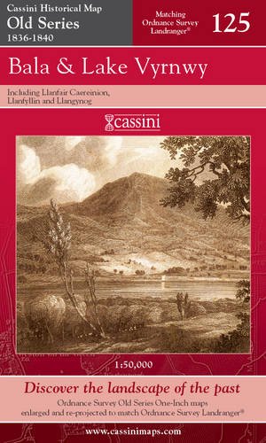
Condición: new. ALL UK PARCELS SENT TRACKED! ALL OVERSEAS PARCELS SENT AIRMAIL, TRACKED! (New, Map, 2006). (1834) 2006 1st edition thus. Folding map in red card covers. This map includes the Elan Valley, Builth Wells, Devil's Bridge, Llangurig, Llandrindod Wells, Llanwrtyd Wells and Rhayader. Fine new copy. "The Cassini Old Seri…es provides a fascinating snapshot of the human geography of Britain in the mid-19th century. These maps are taken from the Ordnance Survey One-Inch 'Old Series' sheets, surveyed between 1791 and1874 and published - with many revisions and new editions - between 1805 and 1874." The original series of maps were 1" to the mile, and surveyed on a grid different from that employed today. Many of the sheets were printed with four separate copper plates each from separate surveys, the edges of which usually did not quite match. Reprints of all these sheets have been available in recent times. In this new series, however, the 1" maps have been reprojected onto the OS National Grid so that all the edges match up. This makes the whole country into one single sheet from which positions can be read off in National Grid numbers. This single sheet has been redivided, creating new sheets each corresponding precisely to a current Landranger map. The scale is now larger, at 1:50,000. This new series is uniquely useful for exploring the land and accurately pinpointing where things are, or used to be. Uniquely useful for comparisons with current maps on the kitchen table, too. Much to be recommended. PREVIOUS PRICE GBP 6.49.
Idioma: Inglés
Editorial: Cassini Publishing Limited. Southampton, Hampshire. 2007 2007
- Primera edición
Librería: Coch-y-Bonddu Books Ltd, MACHYNLLETH, Reino UnidoCoch-y-Bonddu Books Ltd
Contactar con el vendedorVendedor de 5 estrellasMiembro de asociación: PBFA
Condición: Nuevo
EUR 1,14
Envío por EUR 11,59Se envía de Reino Unido a Estados Unidos de AmericaCantidad disponible: 5 disponibles
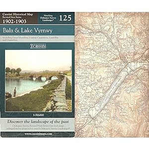
Condición: new. ALL UK PARCELS SENT TRACKED! ALL OVERSEAS PARCELS SENT AIRMAIL, TRACKED! (New, Map, 2007). (1903) 2007 1st edition thus. Folding map in green-blue card covers. This map includes Llanfair Caereinion, Dinas Mawddwy, Llanuwcllyn, Bala, Llanfyllin, Llangynog and Corwen. Fine new copy. The Cassini Revised New Series p…rovides a fascinating snapshot of the humangeography of Britain at the turn of the twentieth century. These maps are taken from the Ordnance Survey One-Inch 'Revised New Series' sheets, surveyed between 1902 and 1903. The original series of maps were 1" to the mile, and surveyed on a grid different from that employed today. In this new series, however, the 1" maps have been reprojected onto the OS National Grid so that all the edges match up. This makes the whole country into one single sheet from which positions can be read off in National Grid numbers. This single sheethas been redivided, creating new sheets each corresponding precisely to a current Landranger map. The scale is now larger, at 1:50,000. This new series is uniquely useful for exploring the land and accurately pin-pointing where things are, or used to be. Useful for comparisons with current maps on the kitchen table, too. Much to be recommended. PREVIOUS PRICE GBP 9.99.
Idioma: Inglés
Editorial: Cassini Publishing Limited. Southampton, Hampshire. 2007 2007
- Primera edición
Librería: Coch-y-Bonddu Books Ltd, MACHYNLLETH, Reino UnidoCoch-y-Bonddu Books Ltd
Contactar con el vendedorVendedor de 5 estrellasMiembro de asociación: PBFA
Condición: Nuevo
EUR 1,14
Envío por EUR 11,59Se envía de Reino Unido a Estados Unidos de AmericaCantidad disponible: 5 disponibles
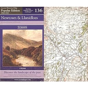
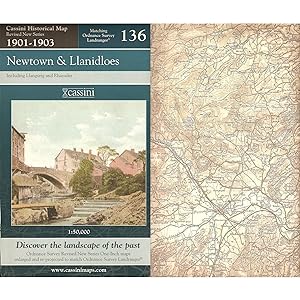
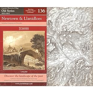
Condición: new. ALL UK PARCELS SENT TRACKED! ALL OVERSEAS PARCELS SENT AIRMAIL, TRACKED! (New, Map, 2007). (1923) 2007 1st edition thus. Folding map in blue card covers. This map includes Newtown, Llanidloes, Llangurig and Rhayader. Fine new copy. The Cassini Popular Edition series provides a fascinating snapshot of the human ge…ography of Britain in the period between the two world wars. These maps are taken from the Ordnance Survey One-Inch 'Popular Edition' sheets, surveyed between 1920 and 1923. The original series of maps were 1" to the mile, and surveyed on a grid different from that employed today. In this new series, however, the 1" maps have been reprojected onto the OS National Grid so that all the edges match up. This makes the whole country into one single sheet from which positions can be read off in National Grid Numbers. This single sheet has been redivided, creating new sheets each corresponding precisely to a current Landranger map. The scale is now larger, at 1:50,000. This new series is uniquely useful for exploring the land and accurately pin-pointing where things are, or used to be. Uniquely useful for comparisons with current maps on the kitchen table too. Much to be recommended. PREVIOUS PRICE GBP 9.99.

Idioma: Inglés
Editorial: Cassini Publishing Limited. Southampton, Hampshire. 2006 2006
Librería: Coch-y-Bonddu Books Ltd, MACHYNLLETH, Reino UnidoCoch-y-Bonddu Books Ltd
Contactar con el vendedorVendedor de 5 estrellasMiembro de asociación: PBFA
Condición: Nuevo
EUR 1,14
Envío por EUR 11,59Se envía de Reino Unido a Estados Unidos de AmericaCantidad disponible: 5 disponibles
Condición: new. ALL UK PARCELS SENT TRACKED! ALL OVERSEAS PARCELS SENT AIRMAIL, TRACKED! (New, Map, 2006). (1840) 2006 1st edition thus. Folding map in red card covers. This map includes Llanfair Caereinion, Llanfyllin, and Llangynog. Fine new copy. "The Cassini Old Series provides a fascinating snapshot of the human geography o…f Britain in the mid-19th century. These maps are taken from the Ordnance Survey One-Inch 'Old Series' sheets, surveyed between 1791 and1874 and published - with many revisions and new editions - between 1805 and 1874." The original series of maps were 1" to the mile, and surveyed on a grid different from that employed today. Many of the sheets were printed with four separate copper plates each from separate surveys, the edges of which usually did not quite match. Reprints of all these sheets have been available in recent times. In this new series, however, the 1" maps have been reprojected onto the OS National Grid so that all the edges match up. This makes the whole country into one single sheet from which positions can be read off in National Grid numbers. This single sheet has been redivided, creating new sheets each corresponding precisely to a current Landranger map. The scale is now larger, at 1:50,000. This new series is uniquely useful for exploring the land and accurately pinpointing where things are, or used to be. Uniquely useful for comparisons with current maps on the kitchen table, too. Much to be recommended. PREVIOUS PRICE GBP 9.99.
Idioma: Inglés
Editorial: Cassini Publishing Limited. Southampton, Hampshire. 2007 2007
- Primera edición
Librería: Coch-y-Bonddu Books Ltd, MACHYNLLETH, Reino UnidoCoch-y-Bonddu Books Ltd
Contactar con el vendedorVendedor de 5 estrellasMiembro de asociación: PBFA
Condición: Nuevo
EUR 1,14
Envío por EUR 11,59Se envía de Reino Unido a Estados Unidos de AmericaCantidad disponible: 5 disponibles
Condición: new. ALL UK PARCELS SENT TRACKED! ALL OVERSEAS PARCELS SENT AIRMAIL, TRACKED! (New, Map, 2007). (1903) 2007 1st edition thus. Folding map in green-blue card covers. This map includes Newtown, Llanidloes, Llangurig and Rhayader. Fine new copy. The Cassini Revised New Series provides a fascinating snapshot of the human…geography of Britain at the turn of the twentieth century. These maps are taken from the Ordnance Survey One-Inch 'Revised New Series'sheets, surveyed between 1900 and 1903. The original series of maps were 1" to the mile, and surveyed on a grid different from that employed today. In this new series, however, the 1" maps have been reprojected onto the OS National Grid so that all the edges match up. This makes the whole country into one single sheet from which positions can be read off in National Grid numbers. This single sheet has been redivided, creating new sheets each corresponding precisely to a current Landranger map. The scale is now larger, at 1:50,000. This new series is uniquely useful for exploring the land and accurately pin-pointing where things are, or used to be. Equally useful for comparisons with current maps on the kitchen table. Much to be recommended. PREVIOUS PRICE GBP 9.99.
Idioma: Inglés
Editorial: Cassini Publishing Limited. Southampton, Hampshire. 2006 2006
Librería: Coch-y-Bonddu Books Ltd, MACHYNLLETH, Reino UnidoCoch-y-Bonddu Books Ltd
Contactar con el vendedorVendedor de 5 estrellasMiembro de asociación: PBFA
Condición: Nuevo
EUR 1,14
Envío por EUR 11,59Se envía de Reino Unido a Estados Unidos de AmericaCantidad disponible: 5 disponibles
Condición: new. ALL UK PARCELS SENT TRACKED! ALL OVERSEAS PARCELS SENT AIRMAIL, TRACKED! (New, Map, 2006). (1837) 2006 1st edition thus. Folding map in red card covers. This map includes Newtown, Llanidloes, Llangurig and Rhayader. Fine new copy. "The Cassini Old Series provides a fascinating snapshot of the human geography of B…ritain in the mid-19th century. These maps are taken from the Ordnance Survey One-Inch 'Old Series' sheets, surveyed between 1791 and1874 and published - with many revisions and new editions - between 1805 and 1874." The original series of maps were 1" to the mile, and surveyed on a grid different from that employed today. Many of the sheets were printed with four separate copper plates each from separate surveys, the edges of which usually did not quite match. Reprints of all these sheets have been available in recent times. In this new series, however, the 1" maps have been reprojected onto the OS National Grid so that all the edges match up. This makes the whole country into one single sheet from which positions can be read off in National Grid numbers. This single sheet has been redivided, creating new sheets each corresponding precisely to a current Landranger map. The scale is now larger, at 1:50,000. This new series is uniquely useful for exploring the land and accurately pinpointing where things are, or used to be. Uniquely useful for comparisons with current maps on the kitchen table, too. Much to be recommended. PREVIOUS PRICE GBP 9.99.
- Tapa blanda
Librería: WorldofBooks, Goring-By-Sea, WS, Reino UnidoWorldofBooks
Contactar con el vendedorVendedor de 5 estrellasCondición: Usado - Aceptable
EUR 12,27
Envío por EUR 6,49Se envía de Reino Unido a Estados Unidos de AmericaCantidad disponible: 1 disponibles
Paperback. Condición: Good. The book has been read but remains in clean condition. All pages are intact and the cover is intact. Some minor wear to the spine.

Librería: WeBuyBooks, Rossendale, LANCS, Reino UnidoWeBuyBooks
Contactar con el vendedorVendedor de 5 estrellasCondición: Usado - Aceptable
EUR 8,69
Envío por EUR 5,33Se envía de Reino Unido a Estados Unidos de AmericaCantidad disponible: 1 disponibles
Condición: Good. Most items will be dispatched the same or the next working day. A copy that has been read but remains in clean condition. All of the pages are intact and the cover is intact and the spine may show signs of wear. The book may have minor markings which are not specifically mentioned.

- Mapa
Librería: Revaluation Books, Exeter, Reino UnidoRevaluation Books
Contactar con el vendedorVendedor de 5 estrellasCondición: Nuevo
EUR 2,53
Envío por EUR 11,59Se envía de Reino Unido a Estados Unidos de AmericaCantidad disponible: 1 disponibles
Map. Condición: Brand New. popular ed edition. 1 pages. 8.50x4.96x0.55 inches. In Stock.

- Mapa
Librería: Revaluation Books, Exeter, Reino UnidoRevaluation Books
Contactar con el vendedorVendedor de 5 estrellasCondición: Nuevo
EUR 2,53
Envío por EUR 11,59Se envía de Reino Unido a Estados Unidos de AmericaCantidad disponible: 1 disponibles
Map. Condición: Brand New. 8.43x5.12x0.55 inches. In Stock.

- Mapa
Librería: Revaluation Books, Exeter, Reino UnidoRevaluation Books
Contactar con el vendedorVendedor de 5 estrellasCondición: Nuevo
EUR 2,53
Envío por EUR 11,59Se envía de Reino Unido a Estados Unidos de AmericaCantidad disponible: 1 disponibles
Map. Condición: Brand New. facsimile edition edition. 1 pages. 8.50x5.12x0.71 inches. In Stock.
- Mapa
Librería: Revaluation Books, Exeter, Reino UnidoRevaluation Books
Contactar con el vendedorVendedor de 5 estrellasCondición: Nuevo
EUR 3,57
Envío por EUR 11,59Se envía de Reino Unido a Estados Unidos de AmericaCantidad disponible: 1 disponibles
Map. Condición: Brand New. 1 pages. 8.94x5.28x0.67 inches. In Stock.
- Mapa
Librería: Revaluation Books, Exeter, Reino UnidoRevaluation Books
Contactar con el vendedorVendedor de 5 estrellasCondición: Nuevo
EUR 3,57
Envío por EUR 11,59Se envía de Reino Unido a Estados Unidos de AmericaCantidad disponible: 1 disponibles
Map. Condición: Brand New. 1 pages. In Stock.
Librería: AMM Books, Gillingham, KENT, Reino UnidoAMM Books
Contactar con el vendedorVendedor de 5 estrellasCondición: Usado - Bueno
EUR 2,09
Envío por EUR 13,89Se envía de Reino Unido a Estados Unidos de AmericaCantidad disponible: 1 disponibles
Map. Condición: Very Good. In stock ready to dispatch from the UK.

Idioma: Inglés
Editorial: Ordnance Survey, Southampton 1988
- Tapa blanda
Librería: K Books Ltd ABA ILAB, York, YORKS, Reino UnidoK Books Ltd ABA ILAB
Contactar con el vendedorVendedor de 5 estrellasCondición: Usado - Bueno
EUR 1,19
Envío por EUR 22,59Se envía de Reino Unido a Estados Unidos de AmericaCantidad disponible: 1 disponibles
Soft Covers. Condición: Very Good. Reprint. folding ordnance survey map - one inch map - excellent condition.
Idioma: Inglés
Editorial: Ordnance Survey, Southampton
- Tapa blanda
Librería: K Books Ltd ABA ILAB, York, YORKS, Reino UnidoK Books Ltd ABA ILAB
Contactar con el vendedorVendedor de 5 estrellasCondición: Usado - Bueno
EUR 1,80
Envío por EUR 22,59Se envía de Reino Unido a Estados Unidos de AmericaCantidad disponible: 1 disponibles
Soft Covers. Condición: Very Good. Reprint. folding ordnance survey map - one inch map -good condition - (covers slightly marked) Carlisle area.
Idioma: Inglés
Editorial: Ordnance Survey, Southampton
- Tapa blanda
Librería: K Books Ltd ABA ILAB, York, YORKS, Reino UnidoK Books Ltd ABA ILAB
Contactar con el vendedorVendedor de 5 estrellasCondición: Usado - Bueno
EUR 1,80
Envío por EUR 22,59Se envía de Reino Unido a Estados Unidos de AmericaCantidad disponible: 1 disponibles
Soft Covers. Condición: Very Good. Reprint. folding ordnance survey map - one inch map -good condition - (covers slightly marked - slighly frayed - internally very good .Hexham area.
Idioma: Inglés
Editorial: Ordnance Survey, Southampton 1988
- Tapa blanda
Librería: K Books Ltd ABA ILAB, York, YORKS, Reino UnidoK Books Ltd ABA ILAB
Contactar con el vendedorVendedor de 5 estrellasCondición: Usado - Bueno
EUR 2,39
Envío por EUR 22,59Se envía de Reino Unido a Estados Unidos de AmericaCantidad disponible: 1 disponibles
Soft Covers. Condición: Very Good. Reprint. folding ordnance survey map - one inch map - excellent condition - Teesdale area - sheet 84.
Idioma: Inglés
Editorial: Ordnance Survey, Southampton 1986
- Tapa blanda
- Mapa
Librería: K Books Ltd ABA ILAB, York, YORKS, Reino UnidoK Books Ltd ABA ILAB
Contactar con el vendedorVendedor de 5 estrellasCondición: Usado - Bueno
EUR 2,39
Envío por EUR 22,59Se envía de Reino Unido a Estados Unidos de AmericaCantidad disponible: 1 disponibles
Soft cover. Condición: Very Good. No Jacket. Reprint -. Excellent copy of the1:50 000, 1 1/4 inch to 1 mile (2 cm to 1 km) series Ordnance Survey Map, folding, original pink covers, revised 1986, very good condition . OFT COVER, NO JACKET, NO MARKINGS, EXCELLENT CONDITION, SPLENDID VALUE . ORDANCE SURVEY MAP OF EDINBURGH AND MID…LOTHIAN AREA.
Idioma: Inglés
Editorial: Ordnance Survey, Southampton 1993
- Tapa blanda
- Mapa
Librería: K Books Ltd ABA ILAB, York, YORKS, Reino UnidoK Books Ltd ABA ILAB
Contactar con el vendedorVendedor de 5 estrellasCondición: Usado - Bueno
EUR 2,39
Envío por EUR 22,59Se envía de Reino Unido a Estados Unidos de AmericaCantidad disponible: 1 disponibles
Soft cover. Condición: Very Good. No Jacket. Reprint -. Excellent copy of the1:50 000, 1 1/4 inch to 1 mile (2 cm to 1 km) series Ordnance Survey Map, folding, original pink covers, revised 1993, very good condition . OFT COVER, NO JACKET, NO MARKINGS, EXCELLENT CONDITION, SPLENDID VALUE . ORDANCE SURVEY MAP OF UPPER CLYDE VALLE…Y.
Idioma: Inglés
Editorial: Ordnance Survey, Southampton 1960
- Tapa blanda
- Mapa
Librería: K Books Ltd ABA ILAB, York, YORKS, Reino UnidoK Books Ltd ABA ILAB
Contactar con el vendedorVendedor de 5 estrellasCondición: Usado - Bueno
EUR 2,39
Envío por EUR 22,59Se envía de Reino Unido a Estados Unidos de AmericaCantidad disponible: 1 disponibles
Soft cover. Condición: Very Good. No Jacket. Reprint. copy of the 1:25,000, 4 Cm to 1 Km, 2 1/2 Inches to 1 mile First series Ordnance Survey Map, folding, original blue covers, derived from pre-1939 surveys, reprinted with minor corrections in 1960. OFT COVER, NO JACKET, NO MARKINGS, EXCELLENT CONDITION, SPLENDID VALUE . ORDANC…E SURVEY MAP OF YETHOLM.
Idioma: Inglés
Editorial: Ordnance Survey, Southampton
- Tapa blanda
- Mapa
Librería: K Books Ltd ABA ILAB, York, YORKS, Reino UnidoK Books Ltd ABA ILAB
Contactar con el vendedorVendedor de 5 estrellasCondición: Usado - Bueno
EUR 2,39
Envío por EUR 22,59Se envía de Reino Unido a Estados Unidos de AmericaCantidad disponible: 1 disponibles
Soft cover. Condición: Very Good. No Jacket. Reprint -. folding - covers - excellent condition . SOFT COVER , NO JACKET, EXCELLENT CONDITION, SPLENDID VALUE . ORDNANCE SURVEY MAP OF BRECON BEACONS, CENTRAL AREA.
Idioma: Inglés
Editorial: Ordnance Survey, Southampton
- Tapa blanda
- Mapa
Librería: K Books Ltd ABA ILAB, York, YORKS, Reino UnidoK Books Ltd ABA ILAB
Contactar con el vendedorVendedor de 5 estrellasCondición: Usado - Bueno
EUR 2,39
Envío por EUR 22,59Se envía de Reino Unido a Estados Unidos de AmericaCantidad disponible: 1 disponibles
Soft cover. Condición: Very Good. No Jacket. Reprint -. folding - covers - excellent condition . SOFT COVER , NO JACKET, EXCELLENT CONDITION, SPLENDID VALUE . ORDNANCE SURVEY MAP OF BRECON BEACONS, WESTERN AREA.
Idioma: Inglés
Editorial: Ordnance Survey, Southampton
- Tapa blanda
- Mapa
Librería: K Books Ltd ABA ILAB, York, YORKS, Reino UnidoK Books Ltd ABA ILAB
Contactar con el vendedorVendedor de 5 estrellasCondición: Usado - Bueno
EUR 2,39
Envío por EUR 22,59Se envía de Reino Unido a Estados Unidos de AmericaCantidad disponible: 1 disponibles
Soft cover. Condición: Very Good. No Jacket. Reprint -. Excellent copy of the 1:50000 Second series Ordnance Survey Map, folding, original printed covers, very good condition . SOFT COVER , NO JACKET, EXCELLENT CONDITION, SPLENDID VALUE . ORDNANCE SURVEY MAP OF PRESTON AND SURROUNDING AREA.


