Map artist (32 resultados)

- Tapa blanda
Librería: AwesomeBooks, Wallingford, Reino UnidoAwesomeBooks
Contactar con el vendedorVendedor de 5 estrellasCondición: Usado - Bueno
EUR 3,53
Envío por EUR 4,83Se envía de Reino Unido a Estados Unidos de AmericaCantidad disponible: 1 disponibles
Condición: Very Good. This book is in very good condition and will be shipped within 24 hours of ordering. The cover may have some limited signs of wear but the pages are clean, intact and the spine remains undamaged. This book has clearly been well maintained and looked after thus far. Money back guarantee if you are not satisf…ied. See all our books here, order more than 1 book and get discounted shipping. .
- Tapa blanda
Librería: WorldofBooks, Goring-By-Sea, WS, Reino UnidoWorldofBooks
Contactar con el vendedorVendedor de 5 estrellasCondición: Usado - Bueno
EUR 4,86
Envío por EUR 6,57Se envía de Reino Unido a Estados Unidos de AmericaCantidad disponible: 1 disponibles
Paperback. Condición: Very Good. The book has been read, but is in excellent condition. Pages are intact and not marred by notes or highlighting. The spine remains undamaged.
- Tapa blanda
Librería: Bahamut Media, Reading, Reino UnidoBahamut Media
Contactar con el vendedorVendedor de 5 estrellasCondición: Usado - Bueno
EUR 3,20
Envío por EUR 8,19Se envía de Reino Unido a Estados Unidos de AmericaCantidad disponible: 1 disponibles
Condición: Very Good. Shipped within 24 hours from our UK warehouse. Clean, undamaged book with no damage to pages and minimal wear to the cover. Spine still tight, in very good condition. Remember if you are not happy, you are covered by our 100% money back guarantee.
- Tapa blanda
Librería: AwesomeBooks, Wallingford, Reino UnidoAwesomeBooks
Contactar con el vendedorVendedor de 5 estrellasCondición: Usado - Bueno
EUR 6,85
Envío por EUR 4,83Se envía de Reino Unido a Estados Unidos de AmericaCantidad disponible: 1 disponibles
Paperback. Condición: Very Good. Finland Baedeker Guide (Baedeker Guides) This book is in very good condition and will be shipped within 24 hours of ordering. The cover may have some limited signs of wear but the pages are clean, intact and the spine remains undamaged. This book has clearly been well maintained and looked after…thus far. Money back guarantee if you are not satisfied. See all our books here, order more than 1 book and get discounted shipping. .
- Tapa blanda
Librería: Bahamut Media, Reading, Reino UnidoBahamut Media
Contactar con el vendedorVendedor de 5 estrellasCondición: Usado - Bueno
EUR 6,85
Envío por EUR 8,19Se envía de Reino Unido a Estados Unidos de AmericaCantidad disponible: 1 disponibles
Paperback. Condición: Very Good. Shipped within 24 hours from our UK warehouse. Clean, undamaged book with no damage to pages and minimal wear to the cover. Spine still tight, in very good condition. Remember if you are not happy, you are covered by our 100% money back guarantee.
- Tapa blanda
Librería: Reuseabook, Gloucester, GLOS, Reino UnidoReuseabook
Contactar con el vendedorVendedor de 5 estrellasCondición: Usado - Aceptable
EUR 3,79
Envío por EUR 11,73Se envía de Reino Unido a Estados Unidos de AmericaCantidad disponible: 1 disponibles
Paperback. Condición: Used; Good. Dispatched, from the UK, within 48 hours of ordering. This book is in good condition but will show signs of previous ownership. Please expect some creasing to the spine and/or minor damage to the cover.

- Tapa blanda
Librería: Shore Books, London, Reino UnidoShore Books
Contactar con el vendedorVendedor de 5 estrellasCondición: Usado - Bueno
EUR 6,04
Envío por EUR 12,91Se envía de Reino Unido a Estados Unidos de AmericaCantidad disponible: 1 disponibles
Soft cover. Condición: Very Good. 2nd Edition. 6 page fold-out including detailed map. (SL#81).
- Tapa blanda
Librería: Ammareal, Morangis, FranciaAmmareal
Contactar con el vendedorVendedor de 5 estrellasCondición: Usado - Muy bueno
EUR 5,55
Envío por EUR 16,50Se envía de Francia a Estados Unidos de AmericaCantidad disponible: 1 disponibles
Softcover. Condición: Bon. Edition 2012. Ammareal reverse jusqu'à 15% du prix net de cet article à des organisations caritatives. ENGLISH DESCRIPTION Book Condition: Used, Good. Edition 2012. Ammareal gives back up to 15% of this item's net price to charity organizations. Various Map Artist (ilustrador).
- Tapa blanda
Librería: Brit Books, Milton Keynes, Reino UnidoBrit Books
Contactar con el vendedorVendedor de 4 estrellasCondición: Usado - Aceptable
EUR 4,34
Envío por EUR 18,76Se envía de Reino Unido a Estados Unidos de AmericaCantidad disponible: 1 disponibles
Paperback. Condición: Used; Good. ***Simply Brit*** Welcome to our online used book store, where affordability meets great quality. Dive into a world of captivating reads without breaking the bank. We take pride in offering a wide selection of used books, from classics to hidden gems, ensuring there is something for every litera…ry palate. All orders are shipped within 24 hours and our lightning fast-delivery within 48 hours coupled with our prompt customer service ensures a smooth journey from ordering to delivery. Discover the joy of reading with us, your trusted source for affordable books that do not compromise on quality.
- Tapa blanda
Librería: Brit Books, Milton Keynes, Reino UnidoBrit Books
Contactar con el vendedorVendedor de 4 estrellasCondición: Usado - Bueno
EUR 4,34
Envío por EUR 18,76Se envía de Reino Unido a Estados Unidos de AmericaCantidad disponible: 1 disponibles
Paperback. Condición: Used; Very Good. ***Simply Brit*** Welcome to our online used book store, where affordability meets great quality. Dive into a world of captivating reads without breaking the bank. We take pride in offering a wide selection of used books, from classics to hidden gems, ensuring there is something for every l…iterary palate. All orders are shipped within 24 hours and our lightning fast-delivery within 48 hours coupled with our prompt customer service ensures a smooth journey from ordering to delivery. Discover the joy of reading with us, your trusted source for affordable books that do not compromise on quality.

- Tapa blanda
Librería: Revaluation Books, Exeter, Reino UnidoRevaluation Books
Contactar con el vendedorVendedor de 5 estrellasCondición: Nuevo
EUR 15,72
Envío por EUR 11,73Se envía de Reino Unido a Estados Unidos de AmericaCantidad disponible: 1 disponibles
Paperback. Condición: Brand New. paperback/map edition. 148 pages. 7.50x4.25x0.75 inches. In Stock.
- Tapa blanda
Librería: Greener Books, London, Reino UnidoGreener Books
Contactar con el vendedorVendedor de 4 estrellasCondición: Usado - Aceptable
EUR 4,34
Envío por EUR 23,47Se envía de Reino Unido a Estados Unidos de AmericaCantidad disponible: 1 disponibles
Paperback. Condición: Used; Good. **SHIPPED FROM UK** We believe you will be completely satisfied with our quick and reliable service. All orders are dispatched as swiftly as possible! Buy with confidence! Greener Books.

Editorial: The Thomas Hardy Society Ltd, 1975
- Tapa blanda
Librería: Shore Books, London, Reino UnidoShore Books
Contactar con el vendedorVendedor de 5 estrellasCondición: Usado - Bueno
EUR 4,83
Envío por EUR 12,91Se envía de Reino Unido a Estados Unidos de AmericaCantidad disponible: 1 disponibles
Añadir al carritoSoft cover. Condición: Very Good. 2nd Edition. 6 page fold-out including detailed map (SL#81).

Editorial: The Thomas Hardy Society Ltd, 1979
- Tapa blanda
Librería: Shore Books, London, Reino UnidoShore Books
Contactar con el vendedorVendedor de 5 estrellasCondición: Usado - Bueno
EUR 6,04
Envío por EUR 12,91Se envía de Reino Unido a Estados Unidos de AmericaCantidad disponible: 1 disponibles
Añadir al carritoSoft cover. Condición: Very Good. 2nd Edition. 6 page fold-out with detailed map. (SL#81).

The Country Of "The Return Of The Native"
J P Skilling (Compiler) and M R Skilling (map artist) / Thomas Hardy
Editorial: The Thomas Hardy Society Ltd, 1975
- Tapa blanda
Librería: Shore Books, London, Reino UnidoShore Books
Contactar con el vendedorVendedor de 5 estrellasCondición: Usado - Bueno
EUR 6,04
Envío por EUR 12,91Se envía de Reino Unido a Estados Unidos de AmericaCantidad disponible: 1 disponibles
Añadir al carritoSoft cover. Condición: Very Good. 3rd Edition. 6 page fold-out including detailed map. (SL#81).

The Country Of "The Trumpet-Major"
J P Skilling (Compiler) and M R Skilling (map artist) / Thomas Hardy
Editorial: The Thomas Hardy Society Ltd, 1974
- Tapa blanda
- Primera edición
Librería: Shore Books, London, Reino UnidoShore Books
Contactar con el vendedorVendedor de 5 estrellasCondición: Usado - Bueno
EUR 6,04
Envío por EUR 12,91Se envía de Reino Unido a Estados Unidos de AmericaCantidad disponible: 1 disponibles
Añadir al carritoSoft cover. Condición: Very Good. 1st Edition. 6 page fold-out including detailed map. (SL#81).

The Country Of "The Hand of Ethelberta"
J P Skilling (Compiler) and M R Skilling (map artist) / Thomas Hardy
Editorial: The Thomas Hardy Society Ltd, 1976
- Tapa blanda
- Primera edición
Librería: Shore Books, London, Reino UnidoShore Books
Contactar con el vendedorVendedor de 5 estrellasCondición: Usado - Bueno
EUR 6,04
Envío por EUR 12,91Se envía de Reino Unido a Estados Unidos de AmericaCantidad disponible: 1 disponibles
Añadir al carritoSoft cover. Condición: Very Good. 1st Edition. 6 page fold-out with detailed map.(SL#81).
Idioma: Inglés
Editorial: MAIRDUMONT GmbH & Co. KG, Germany, Ostfildern, 2012
- Tapa blanda
Librería: WorldofBooks, Goring-By-Sea, WS, Reino UnidoWorldofBooks
Contactar con el vendedorVendedor de 5 estrellasCondición: Usado - Bueno
EUR 25,77
Envío por EUR 6,57Se envía de Reino Unido a Estados Unidos de AmericaCantidad disponible: 4 disponibles
Paperback. Condición: Very Good. This superb full-colour, illustrated guide features 3D laminated cut-outs to show you the key sights of the Algarve in perspective and a large, fully-indexed, pull-out map. Additional detailed maps and plans can also be found throughout the guide, clearly pin-pointing the best places to stay and…the top places to eat and drink. At the heart of the guide is a wealth of comprehensive information written by experts on the sights and top attractions, in an easy-to-read A-Z format. Also included are great, practical travel tips covering accommodation and food and drink for all budgets, entertainment, sport, transport and health; not to mention some insider tips for saving money or having a unique travel experience. There is also a variety of recommended tours covering the best routes available, to ensure you get the most from your destination. The plastic wallet allows you to keep the guide and map together and ensures that both will survive in all weather. Baedeker - setting a new standard in 21st century travel guide publishing. The book has been read, but is in excellent condition. Pages are intact and not marred by notes or highlighting. The spine remains undamaged.

Editorial: A Del Rey Book / Ballantine Books, (New York), 1985
- Tapa dura
- Primera edición
Librería: Heartwood Books and Art, Fort Lauderdale, FL, Estados Unidos de AmericaHeartwood Books and Art
Contactar con el vendedorVendedor de 5 estrellasCondición: Usado - Excelente
EUR 18,07
Envío por EUR 6,14Se envía dentro de Estados Unidos de AmericaCantidad disponible: 1 disponibles
Añadir al carritoHardcover. Condición: Fine. Estado de la sobrecubierta: Fine. First Edition. King's Justice by Katherine Kurtz (First Edition) Sharp tight copy. Sharp bright dust jacket with a trace of wear to corner tips and spine bottom edge. Not price-clipped. Mylar cover. First printing 1-10. Fantasy. Included are indices to characters, to…place names, and to ""A Partial Lineage of the Haldane Kings."". Darrell K. Sweet(Cover Artist) Shelly Shapiro (Map)(Interior Artist) (ilustrador). BOOK.
- Tapa blanda
Librería: Stephen White Books, Bradford, Reino UnidoStephen White Books
Contactar con el vendedorVendedor de 5 estrellasCondición: Usado - Aceptable
EUR 0,89
Envío por EUR 39,01Se envía de Reino Unido a Estados Unidos de AmericaCantidad disponible: 1 disponibles
paperback. Condición: Good. Ex-library book, usual marking. Clean copy in good condition. Quick dispatch from UK seller.

Editorial: Gotha, Justus Perthes, 1859
- Tapa blanda
- Primera edición
- Arte / Grabado / Póster
Librería: Dorley House Books, Inc., Hagerstown, MD, Estados Unidos de AmericaDorley House Books, Inc.
Contactar con el vendedorVendedor de 4 estrellasCondición: Usado - Bueno
EUR 36,13
Envío por EUR 7,59Se envía dentro de Estados Unidos de AmericaCantidad disponible: 1 disponibles
Añadir al carritoUnbound. Condición: Very Good. 1st. Lovely uncolored lithographic map on Finland (1859), suitable for framing Size: 11.5" x 9.75". b/w Map of Finland, raph, uncolored as Published; Artist Petermann, A. (ilustrador).

Editorial: Grosset & Dunlap, New York, 1955
- Tapa dura
Librería: Heartwood Books and Art, Fort Lauderdale, FL, Estados Unidos de AmericaHeartwood Books and Art
Contactar con el vendedorVendedor de 5 estrellasCondición: Usado - Bueno
EUR 54,20
Envío por EUR 6,14Se envía dentro de Estados Unidos de AmericaCantidad disponible: 1 disponibles
Añadir al carritoHardcover. Condición: Very Good. Reprint Edition. The Return of Tarzan by Edgar Rice Burroughs 1950's Minor bumping and rubbing to corners and spine ends. G&D 1950s reprint (of McClurg, 1915). Orange boards, dark brown cover illustration and lettering. 314 pages. Map endpapers. Rafael Palacios (Map endpapers.)(Interior Artist) (…ilustrador). BOOK.

- Tapa blanda
Librería: BennettBooksLtd, Los Angeles, CA, Estados Unidos de AmericaBennettBooksLtd
Contactar con el vendedorVendedor de 5 estrellasCondición: Nuevo
EUR 110,52
Envío por EUR 6,10Se envía dentro de Estados Unidos de AmericaCantidad disponible: 1 disponibles
paperback. Condición: New. In shrink wrap. Looks like an interesting title.

Editorial: Grosset and Dunlap, New York
- Tapa dura
Librería: Heartwood Books and Art, Fort Lauderdale, FL, Estados Unidos de AmericaHeartwood Books and Art
Contactar con el vendedorVendedor de 5 estrellasCondición: Usado - Muy bueno
EUR 90,33
Envío por EUR 6,14Se envía dentro de Estados Unidos de AmericaCantidad disponible: 1 disponibles
Añadir al carritoHardcover. Condición: Near Fine. Estado de la sobrecubierta: Very Good+. Reprint Edition. Tarzan the Untamed by Edgar Rice Burroughs Firm copy with minor rubbing to corners, spine ends and along board edges. Bright dust jacket with minor wear to edges and spine ends. In clear protective cover. G&D 1950s reprint (of Burroughs, In…c. 1920). Red-brown tweed, dark brown cover illustration and lettering. 319 pages. Map endpapers by Rafael Palacios. Rafael Palacios (Map endpapers.)(Interior Artist) (ilustrador). BOOK.
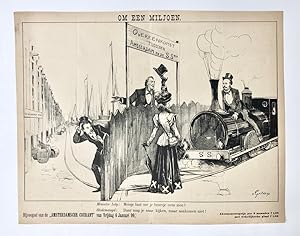
[Original lithograph/lithografie van v. Geldorp] Om een miljoen, 6 Januari 1899, 1 pp.
(Jaillot, Hubert), (Likely) Alff, Paul van (1896-1983), [Artist unknown], [Caricatural map]
Librería: Antiquariaat Arine van der Steur / ILAB, Den Haag, HolandaAntiquariaat Arine van der Steur / ILAB
Contactar con el vendedorVendedor de 5 estrellasCondición: Usado
EUR 24,20
Envío por EUR 30,00Se envía de Holanda a Estados Unidos de AmericaCantidad disponible: 1 disponibles
Añadir al carritoNo binding. 300 x 290 mm. Bijvoegsel van de "Amsterdamsche Courant" van 6 Januari 1899. Pictured are Minister Lely (Minister van Waterstaat, Handel en Nijverheid) and the 'Stedemaagd'. Lithograph, total: 300 x 290; on paper. Folding lines in the middle of the print.

Editorial: Henry Teesdale & Co. (1836)., London., 1836
- Tapa dura
Librería: Asia Bookroom ANZAAB/ILAB, Canberra, ACT, AustraliaAsia Bookroom ANZAAB/ILAB
Contactar con el vendedorVendedor de 5 estrellasCondición: Usado
EUR 158,09
Envío por EUR 18,64Se envía de Australia a Estados Unidos de AmericaCantidad disponible: 1 disponibles
Añadir al carritoEngraved map coloured in outline, 33.7 x 41.5 cms; 38.7 x 48 cms (sheet including platemark), relief shown by hachures, central fold, all edges gilt, in very good condition. An very attractive map prepared for Teesdale's "A New General Atlas of the World.".
 Más imágenes
Editorial: New York: Harcourt, Brace and Company, 1938, New York, 1938
- Tapa dura
- Primera edición
Librería: Brainerd Phillipson Rare Books, Holliston, MA, Estados Unidos de AmericaBrainerd Phillipson Rare Books
Contactar con el vendedorVendedor de 5 estrellasMiembro de asociación: SNEAB
Condición: Usado
EUR 225,83
Envío por EUR 13,16Se envía dentro de Estados Unidos de AmericaCantidad disponible: 1 disponibles
Añadir al carritoAttractively bound in woven red cloth stamped in gilt with a plane own the front boards and the spine. With a touch of fading to the spine. In a very good dust jacket with the price of $2.50 and a faint vertical crease along the front inside flap. Faint scratch to the center of the front panel of the jacket. LINDBERGH, Anne Morr…ow Listen! the Wind New York: Harcourt, Brace and Company, 1938. First edition. Foreword and map drawings by Charles A. Lindbergh. Neat ownership signature of American woman artist Meta Grimm Lacey, a couple of tiny spots on t (ilustrador).

[Pictorial map of the States of Washington and Oregon].
[PACIFIC NORTHWEST -- PICTORIAL MAP OF WASHINGTON & OREGON]. PETRUCELLI, A.[ntonio (Cartographer Artist).]
Editorial: Fortune Magazine, March, 1940]., [New York, NY:, 1940
- Tapa blanda
- Primera edición
Librería: Zephyr Used & Rare Books, Vancouver, WA, Estados Unidos de AmericaZephyr Used & Rare Books
Contactar con el vendedorVendedor de 5 estrellasCondición: Usado
EUR 338,75
Envío por EUR 7,02Se envía dentro de Estados Unidos de AmericaCantidad disponible: 1 disponibles
Añadir al carritoOne atlas folio sized map, 22.25 x 27.5 in. archivally mounted on linen sized 26 x 31.25 in., in excellent bright condition. First edition of this eye-catching pictorial map celebrating the regions, resources, and inhabitants of Washington & Oregon chronicling the impact of the New Deal programs including the construction of Bon…neville Dam, and ongoing massive project of the Grand Coulee. The 1940 Fortune magazine which highlighted the growing economic potential of the Pacific Coast states including Washington, Oregon & California details as well through charming caricature pictographs including sheaves of wheat, cattle, salmon fishermen, logging, tulip growers, apple and peach growers, Native American Reservations, and more. Petrucelli (1907-1994) launched his career as a textile designer, later began illustrating for House Beautiful, Fortune Magazine, The New Yorker, and Collier's Today, who would illustrate charts, diagrams, cover art, caricatures, and won several important design awards. During World War II he also illustrated propaganda maps, and ALCOA maps detailing the company's worldwide operations. Worldcat locates 3 copies (UCT, Buffalo & Erie Pub. Lib., U of O).
 Más imágenes
Editorial: Chicago Daily Tribune. 28 July1945., Chicago., 1945
Librería: Asia Bookroom ANZAAB/ILAB, Canberra, ACT, AustraliaAsia Bookroom ANZAAB/ILAB
Contactar con el vendedorVendedor de 5 estrellasCondición: Usado
EUR 249,78
Envío por EUR 18,64Se envía de Australia a Estados Unidos de AmericaCantidad disponible: 1 disponibles
Añadir al carritoColour bird's eye view map, 22.4 x 39.3 cms on a newspaper leaf trimmed to a half sheet 29.8 x 41.6 cms (including caption), slight toning at an old central fold, the map in very good condition. Unrelated black and white photographic illustrations on the verso "Pre-flight Trainers used in Chicago to give ground instruction to wo…uld-be pilots" and "New rekindled Montauk Light, Long Island, N.Y." Map published in the Chicago Daily Tribune days before the bombing of Hiroshima on August 6,1945. "Perspective map of Tokyo bay and contiguous land and sea areas, showing Tokyo, Yokohama, the Yokosuka naval base, industrial sections and other features .In this map north is at the right instead of at the top - an expedient adopted to show all of the bay as large as possible in half page space." (caption).
Editorial: Advertising Agencies' Service Co New Yorkn.y., New York
- Mapa
Librería: Main Street Fine Books & Mss, ABAA, Galena, IL, Estados Unidos de AmericaMain Street Fine Books & Mss, ABAA
Contactar con el vendedorVendedor de 5 estrellasCondición: Usado
EUR 271,00
Envío por EUR 5,26Se envía dentro de Estados Unidos de AmericaCantidad disponible: 1 disponibles
Añadir al carritoFolio (13½" X 17", folds down to 3¼" X 8½"), housed in 8vo stiff green pictorial folder (cover title: "Map of New York"). Map very good, folder near fine. 1" edge tear near the center of the top edge, along one of the fold lines (neatly, archivally closed on verso); original, as-issued folds present but otherwise not weakened. T…his delightful, cartoonish map is printed in black on a thin, translucent onion-skin paper, and depicts a small area of Manhattan. Cartouche (in shape of a hip flask!) at lower right bears title cited above (along with "April 30th 7 P.M. / Make your reservations now / no tickets sold at the door"). Within this roughly-rectangular shaped decorative border runs the following (one line to each side): "FOR ITS ALWAYS FAIR WEATHER / WHEN GOOD FELLOWS GET TOGETHER / WITH A STEIN ON THE TABLE / AND A GOOD SONG RINGING CLEAR." Above this border, along the top edge, runs the caption in mock Colonial style: "Plates Respektfully & Mechanickally ENGRAV'D by Ye HAGOPIAN PHOTO ENGRAVING CO., Inc., Artisans of Greate SKILL, Expressly for Ye Occasion, and for ye PLEASURE of Master WHITEHEAD in Especiall." Below this border, along the bottom edge, runs another mock Colonial caption: "Printed & Bound with CARE by Ye Craftsmen yclept: Advertising Agencies' Service Co., And PRESENTED Gratis, albeit with GOOD GRACE, to Ye MOST WORSHIPPFULL Company of Ye ART Directors." The map itself shows the several block radius around the intersection of Broadway and 30th Street, with a number of buildings (Hofbrau, Lipsitz Bros. Cloaks & Suits, Daly's Theatre, John L's Place, etc.) depicted rather three-dimensionally. A Chinaman puffs a pipe atop a chop suey restaurant, a horse-drawn carriage rolls down a street, two cats face off atop a building and other bits of activity take place throughout. Commercial artist Walter Whitehead was born in 1874, and died in 1956, which helps date this undated piece -- presumably to later in his life, perhaps his retirement. The Art Directors Club was founded in 1920 "for the progress of art in advertising and industry" (according to their 1921 exhibition catalogue) and both Otto Rebele and Whitehead were among its founding members. About Rebele little is known. He was born around 1878 and was both commercial artist and book illustrator. This scarce and delicate map is a rare survivor, obviously printed in a small quantity for distribution to the membership of this specialized trade association.


