
Importe total (1 artículo artículos):
Destino del pedido:

map leicestershire (82 resultados)
Ir a los resultados principales
Filtros de búsqueda
Tipo de artículo
- Todos los tipos de productos
- Libros (48)
- Revistas y publicaciones (No hay ningún otro resultado que coincida con este filtro.)
- Cómics (No hay ningún otro resultado que coincida con este filtro.)
- Partituras (No hay ningún otro resultado que coincida con este filtro.)
- Arte, grabados y pósters (1)
- Fotografías (No hay ningún otro resultado que coincida con este filtro.)
- Mapas (33)
- Manuscritos y coleccionismo de papel (No hay ningún otro resultado que coincida con este filtro.)
Condición Más información
- Nuevo (8)
- Como nuevo, Excelente o Muy bueno (1)
- Bueno o Aceptable (37)
- Regular o Pobre (No hay ningún otro resultado que coincida con este filtro.)
- Tal como se indica (36)
Encuadernación
Más atributos
Idioma (2)
Gastos de envío gratis
Ubicación del vendedor
Valoración de los vendedores
-

Leicestershire & Rutland (1900): Cassini Historical Map, Rolled (BCO-LER)
Idioma: Inglés
Publicado por Cassini Historical Maps, United Kingdom, 2016
ISBN 10: 184736618X ISBN 13: 9781847366184
Librería: Pendleburys - the bookshop in the hills, Llanwrda, Reino Unido
Calificación del vendedor: 5 de 5 estrellas

Mapa
EUR 8,93
Envío por EUR 13,29
Se envía de Reino Unido a Estados Unidos de AmericaCantidad disponible: 1 disponibles
Ańadir al carritoSoft cover. Condición: Fine. No Jacket. historical rolled County map of Leicestershire and Rutland as it was in 1900 measuring 20" x 14" (500mm x 350mm), a new copy in colours, securely enclosed in a gilt coloured post tube.
-

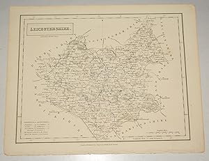
MAP OF LEICESTERSHIRE AND RUTLAND- 1894
Publicado por William Mackenzie, United Kingdom, 1894
Librería: Winghale Books, South Kelsey, LINCS, Reino Unido
Calificación del vendedor: 5 de 5 estrellas
EUR 4,76
Envío por EUR 20,80
Se envía de Reino Unido a Estados Unidos de AmericaCantidad disponible: 1 disponibles
Ańadir al carritoSoft cover. Condición: Very Good. This is the 1894 coloured maps of Leicestershire and Rutland taken from 'The comprehensive gazetteer of England and Wales' edited by J.H.F. Brabner, published in 1894. Each map measures 32 x 25 cms and has a centre fold.
-

Leicestershire Map
Publicado por Maynard & Bradley, Leicester, 1836
Librería: Maynard & Bradley, Leicester, Reino Unido
Calificación del vendedor: 5 de 5 estrellas
EUR 3,51
Envío por EUR 25,37
Se envía de Reino Unido a Estados Unidos de AmericaCantidad disponible: 2 disponibles
Ańadir al carritoSoft cover. Condición: Very Good. Why on Amazon do most sellers not describe their actual book? Buy with confidence and support a genuine Independent Bricks & Mortar Real Bookshop. We are Maynard & Bradley CAMBO & PBFA(now lapsed) members here in Leicester City Centre. Size: 256 x 320 mm. 1 pages. Item Type: Modern Print. Modern facsimile Print on off white paper with the correct water absorbancy for hand colouring and very near to the original in texture substance and colour with a few nicks and handling creases from storage but in the main very good condition to well outside the image area plus a good border. Quantity Available: 1. Shipped Weight: Under 500 grams. Category: Geography & Maps; Map; Britain/UK; 19th century; Pictures of this item not already displayed here available upon request. Inventory No: 30015.
-

Leicestershire Map with 'both Countye and Citie described'
Publicado por Maynard & Bradley, leicester, 1676
Librería: Maynard & Bradley, Leicester, Reino Unido
Calificación del vendedor: 5 de 5 estrellas
EUR 3,51
Envío por EUR 25,37
Se envía de Reino Unido a Estados Unidos de AmericaCantidad disponible: 5 disponibles
Ańadir al carritoSoft cover. Condición: Very Good. The Honorable Famylies that have had the titles of Earls there of. With other accidents therein observed' rear of the map is plain Why on Amazon do most sellers not describe their actual book? Buy with confidence and support a genuine Independent Bricks & Mortar Real Bookshop. We are Maynard & Bradley CAMBO & PBFA(now lapsed) members here in Leicester City Centre. Size: 566 x 445 mm. 1 pages. Item Type: Print. Modern facsimile Print on off white paper with the correct water absorbancy for hand colouring and very near to the original in texture substance and colour with a few nicks and handling creases from storage but in the main very good condition to well outside the image area plus a good border. Quantity Available: 1. Shipped Weight: Under 500 grams. Category: Geography & Maps; Map; Britain/UK; Renaissance 16thc to 17thc; Pictures of this item not already displayed here available upon request. Inventory No: 30016.
-

Leicestershire Map. 1831
Publicado por Lewis, 1831
Librería: Neville Chapman, Bacup, Reino Unido
Calificación del vendedor: 4 de 5 estrellas

Original o primera edición
EUR 11,90
Envío por EUR 10,40
Se envía de Reino Unido a Estados Unidos de AmericaCantidad disponible: 1 disponibles
Ańadir al carritoSingle Sheet. Condición: Good. 1st Edition. Uncoloured map extracted from Lewis' Topographical Dictionary of England. Slight marking and line mark where large maps folded. Most counties in stock. Email for further details.Engraved by J & C Walker. Map.
-

1:2500 Ordnance Survey Map, Leicestershire Sheet XIV.1, Second Edition 1904, Surveyed in 1884, Revised in 1902, Reprint 40/41, Large-scale plan of the area north of the village of Saltby in Leicestershire
Publicado por Ordnance Survey, 1904
Librería: Bailgate Books Ltd, Doncaster, Reino Unido
Calificación del vendedor: 5 de 5 estrellas
Mapa
EUR 9,05
Envío por EUR 16,76
Se envía de Reino Unido a Estados Unidos de AmericaCantidad disponible: 1 disponibles
Ańadir al carritoSingle sheet. Condición: Very Good. Estado de la sobrecubierta: No Dust Jacket. Revised Edition. Includes: Saltby Lodge, farm (Swallow Hole Farm), farm (Barn Lodge Farm) , farm (Heath Farm), Swallowhole Covert, Swallow Hole (geological feature), Bescaby Oaks and Croxton Park (Old Wood). Parts of parishes included are: Saltby, Bescaby and Croxton Kerrial. The area is in the Melton Mowbray Union & RD and Grantham Union and Bevoir RD. Information included is buildings, property/field boundaries, acreage, parish and other boundaries, footpaths, tracks, roads, railways, watercourses, orchards and forestation, levels, earthworks, antiquities etc. The map has an inked stamp in the bottom margin and reference number in the bottom right corner (margin). Item Type: Map. Quantity Available: 1. Shipped Weight: under 1 kg. Pictures of this item not already displayed here available upon request. Inventory No: 45110120060. All our books are sent by tracked mail.
-

MAP OF Lutterworth 1902: Leicestershire Sheet 49.13 (Old Ordnance Survey Maps of Leicestershire)
Librería: GENERATIONS GONE BY, Manchester, Reino Unido
Calificación del vendedor: 5 de 5 estrellas
Mapa
EUR 3,51
Envío por EUR 35,19
Se envía de Reino Unido a Estados Unidos de AmericaCantidad disponible: 1 disponibles
Ańadir al carritoNo Binding. Condición: New. No Jacket. Here are the details of maps for Lutterworth: Leicestershire 49.13 Lutterworth 1902 - published 2023; intro by Barrie Trinder. ISBN.978-1-78721-632-7 This detailed map gives very good coverage of Lutterworth. The map is double-sided for maximum coverage and includes part of adjacent sheet 48.16. Features include the town centre with individual buildings neatly shown, Lutterworth Union Workhouse, GCR railway with station, St Mary's church, Spital Corn Mill. Coverage also includes Misterton, with St Leonard's church and Misterton Hall, and part of Walcote, including Walcote House. We also include a specially written introduction to the history of the area.
-

MAP OF KEGWORTH 1899 Leicestershire Sheet 10.02 (Old Ordnance Survey Maps of Leicestershire)
Librería: GENERATIONS GONE BY, Manchester, Reino Unido
Calificación del vendedor: 5 de 5 estrellas
Mapa
EUR 3,51
Envío por EUR 35,19
Se envía de Reino Unido a Estados Unidos de AmericaCantidad disponible: 1 disponibles
Ańadir al carritoNo Binding. Condición: New. No Jacket. Here are the details of maps for Kegworth: Leicestershire 10.01 Kegworth 1899 - published 2023; intro by Barrie Trinder. ISBN.978-1-78721-638-9 This detailed map gives very good coverage of Kegworth. It is double-sided for maximum coverage and includes part of adjacent sheet 10.06. Features include the town centre with individual buildings neatly shown, St Andrew's church, brewery, plaster mills, Bridge Fields, River Soar, The Lodge, Slade House, The Wymeshead etc. We also include a specially written introduction to the history of the area. The map links up with sheet 10.01 Castle Donington.
-

Leicestershire Footpaths Association map of Footpaths & Bridle Roads in the Neighbourhood of Leicester
Publicado por Leicestershire Footpaths Association, Leicester, 1904
Librería: Aucott & Thomas, Ibstock, Reino Unido
Calificación del vendedor: 5 de 5 estrellas
Original o primera edición
EUR 17,14
Envío por EUR 17,33
Se envía de Reino Unido a Estados Unidos de AmericaCantidad disponible: 1 disponibles
Ańadir al carritoSoftcover. Condición: Good. First Edition. Foldout map on linen, blue card covers with a few marks and initials on the front cover. Map approx 24 inches x 24 inches when open. Covers an area north east of Leicester (Mountsorrel to Rearsby down to Abbey Park and Evington).
-

MAP OF BARROW-UPON-SOAR 1901 LEICESTERSHIRE SHEET 18.10
Librería: GENERATIONS GONE BY, Manchester, Reino Unido
Calificación del vendedor: 5 de 5 estrellas
Mapa
EUR 3,51
Envío por EUR 35,19
Se envía de Reino Unido a Estados Unidos de AmericaCantidad disponible: 1 disponibles
Ańadir al carritoNo Binding. Condición: New. No Jacket. Here are the details of maps for Barrow-upon-Soar: Leicestershire 18.10 Barrow-upon-Soar 1901 - published 2023; intro by Barrie Trinder. ISBN.978-1-78721-640-2 This detailed map gives very good coverage of Barrow-upon-Soar Features include village centre with individual buildings neatly shown, railway with station, Holy Trinity church, Strancliffe, Fishpool Brook etc. We also include an 1891 directory of Barrow-upon-Soar together with a specially written introduction to its history.
-

MAP OF QUORN 1902 LEICESTERSHIRE SHEET 18.13
Librería: GENERATIONS GONE BY, Manchester, Reino Unido
Calificación del vendedor: 5 de 5 estrellas
Mapa
EUR 3,51
Envío por EUR 35,19
Se envía de Reino Unido a Estados Unidos de AmericaCantidad disponible: 1 disponibles
Ańadir al carritoNo Binding. Condición: New. No Jacket. Here are the details of maps for Quorn: Leicestershire 18.13 Quorn 1902 - published 2023; intro by Barrie Trinder. ISBN.978-1-78721-641-9 This detailed map gives very good coverage of Quorn or Quorndon. Features include village centre with individual buildings neatly shown, Quorndon House and grounds, Weir Hosiery Manufactory, St Bartholomew's church, New Quorndon, chapels, Quorndon Mill etc. Coverage extends west to the Great Central Railway and Quorndon station. We also include a directory of Quorndon in 1891.
-

MAP OF SHEPSHED 1901 LEICESTERSHIRE SHEET 17.06
Librería: GENERATIONS GONE BY, Manchester, Reino Unido
Calificación del vendedor: 5 de 5 estrellas
Mapa
EUR 3,51
Envío por EUR 35,19
Se envía de Reino Unido a Estados Unidos de AmericaCantidad disponible: 1 disponibles
Ańadir al carritoNo Binding. Condición: New. No Jacket. Here are the details of maps for Shepshed: Leicestershire 17.06 Shepshed 1901 - published 2023; intro by Alan Lamb. ISBN.978-1-78721-647-1 This detailed map gives very good coverage of the small town of Shepshed. Features include St Botolph's church, hosiery factories, boot & shoe factory, Market Place, Ring Fence, cemetery, line of old canal, chapels, Bull Ring, town centre shown with individual buildings neatly shown, etc. We also include a directory of the town in 1891.
-

LEICESTERSHIRE . ANTIQUE MAP PRINTED IN 1868
Idioma: Inglés
Publicado por VIRTUE, London, 1868
Librería: K Books Ltd ABA ILAB, York, YORKS, Reino Unido
Miembro de asociación: ABA ILAB PBFA
Calificación del vendedor: 5 de 5 estrellas
EUR 17,85
Envío por EUR 22,53
Se envía de Reino Unido a Estados Unidos de AmericaCantidad disponible: 1 disponibles
Ańadir al carritoNo Binding. Condición: Very Good. A SPLENDID ORIGINAL ANTIQUE MAP, NOT DATED BUT PRINTED IN 1868. MOUNTED AND READY TO FRAME. VERY GOOD CONDITION . PRINTED IN COLOUR . SHOWS THE COUNTY OF LEICESTERSHIRE - SHOWS VILLAGES, HAMLETS, RAILWAYS ETC.
-

Leicestershire, 1951 Miniature County Map Reproduction
Publicado por Penguin, UK, 1945
Librería: Maynard & Bradley, Leicester, Reino Unido
Calificación del vendedor: 5 de 5 estrellas
EUR 13,04
Envío por EUR 25,37
Se envía de Reino Unido a Estados Unidos de AmericaCantidad disponible: 1 disponibles
Ańadir al carritoHardcover. Condición: Good. Estado de la sobrecubierta: No Dust Jacket. 1951. A clean and well-presented full colour reproduction of a map by John Speed, produced for King Penguin in 1951. Professionally mounted and suitable for framing or display. Why do most sellers not describe their actual item? Buy with confidence, support a genuine Independent Bricks & Mortar Real Bookshop and help to preserve our High Streets as interesting places to shop. We are Maynard & Bradley CAMBO & PBFA (now lapsed) members here in Leicester City Centre, UK Size: 265 x 225 mm. 1. Item Type: Book. Quantity Available: 1. Shipped Weight: Under 500 grams. Category: Geography & Maps; Britain/UK; 1950s; Inventory No: 53905.
-

1840 - Leicestershire. An uncoloured map, folded as issued, approx. 25 x 30 cms. An original detailed map from The Parliamentary Gazetteer of England & Wales, Published in 1840.
Publicado por Fullarton & Co., Glasgow, 1840
Librería: Cosmo Books, Shropshire., Reino Unido
Calificación del vendedor: 5 de 5 estrellas
EUR 19,29
Envío por EUR 13,75
Se envía de Reino Unido a Estados Unidos de AmericaCantidad disponible: 1 disponibles
Ańadir al carritoAn Unframed Map. Condición: Very Good. Some foxing. An engraved map, image area 18 x 24 cms approx., with 11 pages of text related to the county. The Parliamentary Gazetteer of England and Wales, published in the early 1840s is a richly detailed topographical and statistical reference work. It was compiled by A. Fullarton & Co. and designed to reflect the sweeping administrative reforms of the time, particularly the Poor Law Amendment Act, municipal restructuring, and parliamentary franchise changes, and its tone is both practical and reform-minded, reflecting the Victorian impulse to catalogue and rationalise the nationââ â˘s fabric. Size: 17 x 27 cms. Category: Parliamentary Gazetteer Maps; Prints of Industrial Arts. Cosmo Books : 29 years on ABE, 47 years taking care of customers. A bookseller you can rely on.
-
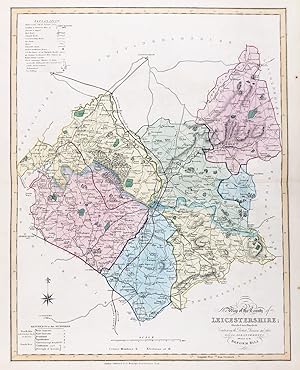
"New Map of the County of Leicestershire; Divided into Hundreds; Containing the District Divisions and other Local Arrangements effected by the Reform Bill" - Leicestershire Melton Mowbray Ashby-de-la-Zouch Leicester Wigston Hinckley
Idioma: Inglés
Publicado por London, 1833
Librería: Antiquariat Steffen Völkel GmbH, Seubersdorf, Alemania
Miembro de asociación: ILAB VDA
Calificación del vendedor: 5 de 5 estrellas
Mapa
EUR 19,99
Envío por EUR 30,00
Se envía de Alemania a Estados Unidos de AmericaCantidad disponible: 1 disponibles
Ańadir al carritoAntique map in original color from 1833. Size: c. 47 x 39 cm. -- in very good condition. || Original handkolorierte Stahlstich-Karte von 1833. -- gut erhalten. || James Ebden's remarkable county maps are typical of the best maps produced for English atlases at the beginning of the 19th century. Skillfully engraved and beautifully hand colored, they are relatively large compared to the majority of other county maps of the early 19th century. Their size allows for a clearer, more detailed depiction of the regions. The maps show the individual counties and all their major roads. They are accompanied by a legend, further explanations of the symbols used, a mileage scale, and a description of the counties' districts and/or other territorial divisions. || Dies ist ein Original! - Kein Nachdruck! - Keine Kopie! -- This is an original! - No copy! - No reprint! Antique map in original color from 1833. Size: c. 47 x 39 cm. -- in very good condition. || Original handkolorierte Stahlstich-Karte von 1833. -- gut erhalten. || James Ebden's remarkable county maps are typical of the best maps produced for English atlases at the beginning of the 19th century. Skillfully engraved and beautifully hand colored, they are relatively large compared to the majority of other county maps of the early 19th century. Their size allows for a clearer, more detailed depiction of the regions. The maps show the individual counties and all their major roads. They are accompanied by a legend, further explanations of the symbols used, a mileage scale, and a description of the counties' districts and/or other territorial divisions. || Dies ist ein Original! - Kein Nachdruck! - Keine Kopie! -- This is an original! - No copy! - No reprint! // Wir, das Antiquariat Steffen Völkel, kaufen und verkaufen alte Bücher, Handschriften, Zeichnungen, Autographen, Grafiken und Fotografien. Wir sind stets am Ankauf von kompletten Bibliotheken, Sammlungen und Nachlässen interessiert. Sprache: Englisch.
-
An engraved antique map of Leicestershire, England
Idioma: Inglés
Ańo de publicación: 1836
Librería: GN Books and Prints, Inverness, Reino Unido
Calificación del vendedor: 5 de 5 estrellas
Mapa
EUR 17,84
Envío por EUR 22,19
Se envía de Reino Unido a Estados Unidos de AmericaCantidad disponible: 1 disponibles
Ańadir al carritoNo Binding. Condición: As Described. No Jacket. Thomas Moule Ilustrador. An engraved antique map of Leicestershire, England, by Thomas Moule, from a copy of "Barclay's Complete and Universal English Dictionary" by the Rev. James Barclay, published 1836-1848. Richly decorated, containing ornate border and a number of vignettes, including coats of arms and illustrations of Belvoir Castle, Ulverscroft Abbey and Donington Castle. Displays Reference to the Hundreds with Scale of Miles. Measures around 8 1/2" x 10 3/4" (217mm x 274mm). The map contains no folds. There are signs of wear with a little tearing and binding holes at right-hand edge. Light foxing and toning, predominantly at extremities, and minor other marking but reasonably clean. See pictures for further information. 1836-1848. n.
-
Ordnance Survey 1 inch map. Sheet 72/73 Leicestershire/Staffordshire/Warwickshire/Worcester
Idioma: Inglés
Publicado por Ordnance Survey, United Kingdom, 1919
Librería: Carmarthenshire Rare Books, Carmarthen, Reino Unido
Calificación del vendedor: 5 de 5 estrellas
EUR 53,56
Envío por EUR 20,80
Se envía de Reino Unido a Estados Unidos de AmericaCantidad disponible: 1 disponibles
Ańadir al carritoSoft cover. Condición: Very Good. Estado de la sobrecubierta: No Jacket Issued. 3rd Edition. Very large linen backed coloured multi folding map measuring, 146cm by 149cm, minor discolouring, a couple of sections hve slight lifting at the corners, a few pencil lines otherwise a very good copy in rubbed gilt lettered leather slipcase titled "Country Round Priors Hardwick." We are a real bookshop with real books situated in and shipping from the United Kingdom. Shelf HC1.
-

Antique 1811 Map of the Arden, Roman Leicestershire
Publicado por Nichols, Leicester, 1811
Librería: Maynard & Bradley, Leicester, Reino Unido
Calificación del vendedor: 5 de 5 estrellas
Original o primera edición
EUR 23,22
Envío por EUR 25,37
Se envía de Reino Unido a Estados Unidos de AmericaCantidad disponible: 1 disponibles
Ańadir al carritoCondición: Very Good. unknown Ilustrador. 1st Edition. This is an original Georgian copperplate 215 x 230 mm. engraving of a Map of Arden. Edges are very neat except four small tears along both left and right sides of paper, one going 10 mm through the plate mark and a few slight creases traveling from the bottom to the top of the paper towards the right hand side. Tears all repaired with conservation tape. Within plate mark on paper sized 270 x 440 mm. Buy with confidence, support a genuine Independent Bricks & Mortar Real Bookshop and help to preserve our High streets as interesting places to shop. We are Maynard & Bradley CAMBO & PBFA(now lapsed) members here in Leicester City Centre, UK Why on Amazon do most sellers not describe their actual book? Buy with confidence and support a genuine Independent Bricks & Mortar Real Bookshop. We are Maynard & Bradley CAMBO & PBFA(now lapsed) members here in Leicester City Centre. 1811. Size: 215 x 230 mm. 1 pages. Item Type: Antique Print. Illustrator: unknown. Quantity Available: 1. Shipped Weight: Under 500 grams. Category: Geography & Maps; Lithos & Prints; Britain/UK; 19th century; Pictures of this item not already displayed here available upon request. Inventory No: 30001. Softcover (Single Sheet of thick paper).
-
An antique map of Leicestershire and Rutlandshire, England, drawn and engraved by John Dower, F.R.G.S., from the Ordnance Survey, taken from a copy of the Supplement to The Weekly Dispatch of Sunday, December 19th, 1858
Idioma: Inglés
Publicado por Weekly Dispatch Atlas, printed by Day & Son, 1858
Librería: GN Books and Prints, Inverness, Reino Unido
Calificación del vendedor: 5 de 5 estrellas
Mapa
EUR 35,70
Envío por EUR 22,19
Se envía de Reino Unido a Estados Unidos de AmericaCantidad disponible: 1 disponibles
Ańadir al carritoNo Binding. No Jacket. John Dower Ilustrador. An antique map of Leicestershire and Rutlandshire, England, drawn and engraved by John Dower, FRGS, from the Ordnance Survey, taken from a copy of the Supplement to The Weekly Dispatch of Sunday, December 19th, 1858, published by Weekly Dispatch Atlas, 139 Fleet Street, printed by Day & Son, Lithographers to The Queen. Contains Scale of English Miles. Measures around 19 1/2" x 13 3/4" (495mm x 350mm). Hand-colouring to county borders. The map contains a central vertical fold. Some edge-wear and creasing, and a few little tears. Coloured stamp to corner containing publication details. A little marking and slight toning around edges but quite clean for age. See pictures for further information. n.
-

Leicestershire in 1777: An Edition of Prior's Map of Leicestershire
Idioma: Inglés
Publicado por Leicestershire Museums, Arts & Records Service, 1985
ISBN 10: 0850221722 ISBN 13: 9780850221725
Librería: WeBuyBooks, Rossendale, LANCS, Reino Unido
Calificación del vendedor: 5 de 5 estrellas
EUR 75,80
Envío por EUR 6,70
Se envía de Reino Unido a Estados Unidos de AmericaCantidad disponible: 1 disponibles
Ańadir al carritoCondición: Very Good. Most items will be dispatched the same or the next working day. A copy that has been read, but is in excellent condition. Pages are intact and not marred by notes or highlighting. The spine remains undamaged.
-
Leicestershire New British Traveller S Neele County Map & Description
Publicado por J. Robins, Albion Press, London, 1819
Librería: Maynard & Bradley, Leicester, Reino Unido
Calificación del vendedor: 5 de 5 estrellas
Original o primera edición
EUR 25,60
Envío por EUR 25,37
Se envía de Reino Unido a Estados Unidos de AmericaCantidad disponible: 1 disponibles
Ańadir al carritoSoftcover. Condición: Good. First Edition. This is an original Georgian engraved map complete with partially bound text block ,ex Dugdale's 'The New British Traveller, or Modern Panorama of England and Wales [.] Forming a Complete Survey of South Britain'. Included is the descriptive text. The map bears some light browning and wear along the edges, some faint damp marks and spots. Page edges are very lightly worn with tiny creases and tears, and pages bear some faint scattered foxing. A close-up photo is available by request. Why on Amazon do most sellers not describe their actual book? Buy with confidence and support a genuine Independent Bricks & Mortar Real Bookshop. We are Maynard & Bradley CAMBO & PBFA(now lapsed) members here in Leicester City Centre. Size: 220 x 270 mm. 40 pages. Item Type: Book. Quantity Available: 1. Shipped Weight: Under 500 grams. Category: Geography & Maps; Britain/UK; 19th century; Pictures of this item not already displayed here available upon request. Inventory No: 03142.
-

Official Tourist Map THE ENGLISH SHIRES (Derbyshire, Leicestershire, Lincolnshire, Northamptonshire & Nottinghamshire
Idioma: Inglés
Publicado por East Midlands Tourist Board/Estate Publications, 1984
ISBN 10: 086084286X ISBN 13: 9780860842866
Librería: Neville Wade, Berkhamsted, Reino Unido
Calificación del vendedor: 5 de 5 estrellas
EUR 14,39
Envío por EUR 28,89
Se envía de Reino Unido a Estados Unidos de AmericaCantidad disponible: 1 disponibles
Ańadir al carritoNo Binding. Condición: Very Good. Circa 1970 - 1:250,000 - very minor corner bumps to cover, otherwise unmarked.
-
Leicestershire an Original Antique Hand Coloured Map
Idioma: Inglés
Publicado por Fullarton, London, 1850
Librería: K Books Ltd ABA ILAB, York, YORKS, Reino Unido
Miembro de asociación: ABA ILAB PBFA
Calificación del vendedor: 5 de 5 estrellas
EUR 35,71
Envío por EUR 22,53
Se envía de Reino Unido a Estados Unidos de AmericaCantidad disponible: 1 disponibles
Ańadir al carritoNo Binding. Condición: Very Good. A splendid original antique hand coloured map . Mounted - matted and ready to frame . Very good condition . Shows a fine study of Leicestershire - with a coloured vignette of Belvoir Castle - very detailed colouring not contemporary but delicately and expertly executed.
-
LEICESTERSHIRE. ANTIQUE MAP.
Idioma: Inglés
Publicado por Dugdale, London, 1843
Librería: K Books Ltd ABA ILAB, York, YORKS, Reino Unido
Miembro de asociación: ABA ILAB PBFA
Calificación del vendedor: 5 de 5 estrellas
EUR 35,71
Envío por EUR 22,53
Se envía de Reino Unido a Estados Unidos de AmericaCantidad disponible: 1 disponibles
Ańadir al carritoNo Binding. Condición: Very Good. LEICESTERSHIRE. .An original antique hand coloured county map. Map size approx. 10 x 8.5 in, 26 x 21 cms. Mounted and ready to frame, mount size approx. 12 x 10 in, 31 x 25 cms, very good condition. Much detail of towns, villages, Country Seats, castles, abbeys, mail coach roads, railways, polling stations, etc. 1843 - drawn & engraved by Archer.
-

Leicestershire Historical 1610 Map 1000 Piece Puzzle
Publicado por ALL JIGSAW PUZZLES, 2024
ISBN 13: 5060085100090
Librería: PBShop.store UK, Fairford, GLOS, Reino Unido
Calificación del vendedor: 5 de 5 estrellas
EUR 24,81
Envío por EUR 5,80
Se envía de Reino Unido a Estados Unidos de AmericaCantidad disponible: 6 disponibles
Ańadir al carritoUNK. Condición: New. New Book. Shipped from UK. Established seller since 2000.
-
Map of Leicestershire (No. LXIII)
Publicado por Ordnance Map Office Tower of London, 1835
Librería: Anybook.com, Lincoln, Reino Unido
Calificación del vendedor: 5 de 5 estrellas
EUR 38,09
Envío por EUR 15,72
Se envía de Reino Unido a Estados Unidos de AmericaCantidad disponible: 1 disponibles
Ańadir al carritoCondición: Good. This is an ex-library book and may have the usual library/used-book markings inside.This book has soft covers. In good all round condition. Sheet No. 63 of a larger set. 34x26.5in. Scale: 1 inch to a statute mile. Shows Leicester, Charnwood Forest, Market Harborough, Nuneaton, Market Bosworth, Part of Derbyshire, Ashby Woulds, Ashby de la Zouch, Atherstone and surrounding areas plus part of Avon shown in purple and blue. Dissected into 15 sections and backed with canvas. Some foxing on map and age related marks on canvas. Has marbled paper covers when folded. Please note the Image in this listing is a stock photo and may not match the covers of the actual item,250grams, ISBN:
-
ORIGINAL ENGRAVED ANTIQUE MAP OF LEICESTERSHIRE.
Publicado por Published by Chapman & Hall No date 1831, 1831
Librería: PROCTOR / THE ANTIQUE MAP & BOOKSHOP, DORCHESTER, Reino Unido
Miembro de asociación: PBFA
Calificación del vendedor: 5 de 5 estrellas
EUR 17,85
Envío por EUR 23,11
Se envía de Reino Unido a Estados Unidos de AmericaCantidad disponible: 1 disponibles
Ańadir al carritoUncoloured Unmounted. In very good condition. Strong impression. Engraved surface Size 24 x 19cm.
-

Antique Map of Lost Villages in Yorkshire, Leicestershire and Warwickshire 1951
Librería: Staffordshire Curios, Haughton, Reino Unido
Calificación del vendedor: 4 de 5 estrellas
Mapa
EUR 14,27
Envío por EUR 17,28
Se envía de Reino Unido a Estados Unidos de AmericaCantidad disponible: 1 disponibles
Ańadir al carritoSheet Map. Original map extracted from a Geographical Journal publication from 1951Approx total paper size is 345 x 235mmMap is in very good condition for age, see photo. Stored and shipped folded down folds seen in photo. A little light extraction wear to left edge.See photo ; 8vo 8" - 9" tall.
-
Map. Leicestershire.
Publicado por 1840. c. 10.25in x 10.5in (Sheet size), 1840
Librería: R.G. Watkins Books and Prints, Ilminster, SOMER, Reino Unido
Calificación del vendedor: 5 de 5 estrellas
EUR 11,90
Envío por EUR 32,36
Se envía de Reino Unido a Estados Unidos de AmericaCantidad disponible: 1 disponibles
Ańadir al carritoMap drawn by R. Creighton, engraved by J. & C. Walker, from Lewis's Topographical Dictionary, vertical fold, very slight foxing, some off-setting,


