Importe total (1 artículo artículos):
Destino del pedido:

county map texas (54 resultados)
Ir a los resultados principales
Filtros de búsqueda
Tipo de artículo
- Todos los tipos de productos
- Libros (43)
- Revistas y publicaciones (No hay ningún otro resultado que coincida con este filtro.)
- Cómics (No hay ningún otro resultado que coincida con este filtro.)
- Partituras (No hay ningún otro resultado que coincida con este filtro.)
- Arte, grabados y pósters (2)
- Fotografías (No hay ningún otro resultado que coincida con este filtro.)
- Mapas (9)
- Manuscritos y coleccionismo de papel (No hay ningún otro resultado que coincida con este filtro.)
Condición Más información
Encuadernación
Más atributos
- Primera edición (8)
- Firmado (No hay ningún otro resultado que coincida con este filtro.)
- Sobrecubierta (1)
- Con imágenes (40)
- No impresión bajo demanda (54)
Idioma (2)
Gastos de envío gratis
Ubicación del vendedor
Valoración de los vendedores
-

SOMERVELL COUNTY TEXAS General Highway Map
Idioma: Inglés
Publicado por State Dept. Of Highways, Austin, 1976
Librería: The Wright Collection, Waxahachie, TX, Estados Unidos de America
Miembro de asociación: TXBA
Calificación del vendedor: 5 de 5 estrellas

Original o primera edición
EUR 13,35
Envío por EUR 5,62
Se envía dentro de Estados Unidos de AmericaCantidad disponible: 1 disponibles
Ańadir al carritoSoft cover. Condición: Fine. 1st. 18" x 24.5" black & white map of Somervell County.
-

Behrens' Vest Pocket Guide of Texas: Containing a List of Railroads and Stations Alphabetically Arranged, a New Map of Texas, Counties, County Seats, . and Population of County (Classic Reprint)
Librería: PBShop.store US, Wood Dale, IL, Estados Unidos de America
Calificación del vendedor: 5 de 5 estrellas
EUR 25,26
Gastos de envío gratis
Se envía dentro de Estados Unidos de AmericaCantidad disponible: 15 disponibles
Ańadir al carritoPAP. Condición: New. New Book. Shipped from UK. Established seller since 2000.
-
THE RAND-McNALLY INDEXED COUNTY AND RAILROAD POCKER MAP AND SHIPPERS' GUIDE OF TEXAS
Idioma: Inglés
Publicado por Rand McNally & Company, Chicago, 1911
Librería: The Wright Collection, Waxahachie, TX, Estados Unidos de America
Miembro de asociación: TXBA
Calificación del vendedor: 5 de 5 estrellas
Original o primera edición
EUR 22,25
Envío por EUR 5,62
Se envía dentro de Estados Unidos de AmericaCantidad disponible: 1 disponibles
Ańadir al carritoStiff Wrs. Condición: Good. No Jacket. 1st Edition. 110 pp., ads, index. Accompanied by a new and original compilation and ready reference index, showing in detail the ENTIRE RAILROAD SYSTEM. Includes population according to the latest Official Census. Covers loose and reattached with archival tape. Fragile.
-
Behrens' Vest Pocket Guide of Texas: Containing a List of Railroads and Stations Alphabetically Arranged, a New Map of Texas, Counties, County Seats, . and Population of County (Classic Reprint)
Librería: PBShop.store UK, Fairford, GLOS, Reino Unido
Calificación del vendedor: 5 de 5 estrellas
EUR 24,70
Envío por EUR 3,81
Se envía de Reino Unido a Estados Unidos de AmericaCantidad disponible: 15 disponibles
Ańadir al carritoPAP. Condición: New. New Book. Shipped from UK. Established seller since 2000.
-

Behrens'' Vest Pocket Guide of Texas: Containing a List of Railroads and Stations Alphabetically Arranged, a New Map of Texas, Counties, County Seats, Geographical Position, and Population of County (Classic Reprint)
Librería: PBShop.store US, Wood Dale, IL, Estados Unidos de America
Calificación del vendedor: 5 de 5 estrellas
EUR 34,63
Gastos de envío gratis
Se envía dentro de Estados Unidos de AmericaCantidad disponible: 15 disponibles
Ańadir al carritoHRD. Condición: New. New Book. Shipped from UK. Established seller since 2000.
-
Behrens'' Vest Pocket Guide of Texas: Containing a List of Railroads and Stations Alphabetically Arranged, a New Map of Texas, Counties, County Seats, Geographical Position, and Population of County (Classic Reprint)
Librería: PBShop.store UK, Fairford, GLOS, Reino Unido
Calificación del vendedor: 5 de 5 estrellas
EUR 33,06
Envío por EUR 4,82
Se envía de Reino Unido a Estados Unidos de AmericaCantidad disponible: 15 disponibles
Ańadir al carritoHRD. Condición: New. New Book. Shipped from UK. Established seller since 2000.
-
LIMESTONE COUNTY TEXAS General Highway Map
Publicado por State Dept. Of Highways, Austin, 1989
Librería: The Wright Collection, Waxahachie, TX, Estados Unidos de America
Miembro de asociación: TXBA
Calificación del vendedor: 5 de 5 estrellas
Original o primera edición
EUR 13,35
Envío por EUR 5,62
Se envía dentro de Estados Unidos de AmericaCantidad disponible: 1 disponibles
Ańadir al carritoCondición: Near Fine. 1st. 18" x 24.5" black & white map of Limestone County.
-
BELL COUNTY TEXAS General Highway Map
Publicado por State Dept. Of Highways, Austin, 1989
Librería: The Wright Collection, Waxahachie, TX, Estados Unidos de America
Miembro de asociación: TXBA
Calificación del vendedor: 5 de 5 estrellas
Original o primera edición
EUR 13,35
Envío por EUR 5,62
Se envía dentro de Estados Unidos de AmericaCantidad disponible: 1 disponibles
Ańadir al carritoCondición: Fine. 1st. 18" x 24.5" black & white map of Bell County.
-
HILL COUNTY TEXAS General Highway Map
Publicado por State Dept. Of Highways, Austin, 1989
Librería: The Wright Collection, Waxahachie, TX, Estados Unidos de America
Miembro de asociación: TXBA
Calificación del vendedor: 5 de 5 estrellas
Original o primera edición
EUR 13,35
Envío por EUR 5,62
Se envía dentro de Estados Unidos de AmericaCantidad disponible: 1 disponibles
Ańadir al carritoCondición: Fine. 1st. 18" x 25" black & white map of Hill County.
-
Geology Of The Sierra Blanca Area, Hudspeth County, Texas [map Volume Only]
Publicado por Department of the Interior, Washington, DC
Librería: Willis Monie-Books, ABAA, Cooperstown, NY, Estados Unidos de America
Miembro de asociación: ABAA ESA ILAB
Calificación del vendedor: 5 de 5 estrellas
EUR 13,35
Envío por EUR 6,91
Se envía dentro de Estados Unidos de AmericaCantidad disponible: 1 disponibles
Ańadir al carritoHardcover. Condición: Very Good. Estado de la sobrecubierta: No Dust Jacket. Folder has catalog number sticker on rear cover, section of rough edge. ; Geological Survey Professional Paper 479. Hardcover "folder" with ten maps in pocket.
-
Presenting Your Map of Dawson County, Texas
Publicado por Dawson County Court House, Lamesa, TX
Librería: Fahrenheit's Books, Denver, CO, Estados Unidos de America
Miembro de asociación: RMABA
Calificación del vendedor: 5 de 5 estrellas
EUR 8,90
Envío por EUR 6,05
Se envía dentro de Estados Unidos de AmericaCantidad disponible: 1 disponibles
Ańadir al carritoFolded Sheet. Condición: Very Good+. Folded single sheet map, has some very slight edgewear, faint rubbing with a couple slight smudges, and a hint of wear to corners, otherwise a solid VG+ copy.
-
Travis County, Texas, The Five Schedules of the 1860 Federal Census with Sample Reproductions of Each Schedule and Map of Travis County, Texas
Idioma: Inglés
Publicado por Privately Published, Austin, Tx, 1967
Librería: TribalBooks, Dallas, TX, Estados Unidos de America
Calificación del vendedor: 5 de 5 estrellas
Original o primera edición
EUR 44,49
Envío por EUR 4,65
Se envía dentro de Estados Unidos de AmericaCantidad disponible: 1 disponibles
Ańadir al carritoHardcover. Condición: Very Good. 1st Edition. Red cloth with title in gilt on spine, xv + 89 pp, tables, lists, index. Private library card pocket to front pastedown, owner name ink stamp to front fly, lightly edgeworn. No jacket as issued. Shelf A2.
-
![Imagen del vendedor de Camp Maxey II, A 5,000 Acre Cultural Resource Survey of Camp Maxey, Lamar County, Texas [and] Map Supplement [Two Volume Set] a la venta por TribalBooks](https://pictures.abebooks.com/inventory/md/md30823046653.jpg)
Camp Maxey II, A 5,000 Acre Cultural Resource Survey of Camp Maxey, Lamar County, Texas [and] Map Supplement [Two Volume Set]
Idioma: Inglés
Publicado por Center for Archaeological Research #312, San Antonio, 2001
Librería: TribalBooks, Dallas, TX, Estados Unidos de America
Calificación del vendedor: 5 de 5 estrellas
Original o primera edición
EUR 44,49
Envío por EUR 4,65
Se envía dentro de Estados Unidos de AmericaCantidad disponible: 1 disponibles
Ańadir al carritoSoft cover. Condición: Near Fine. 1st Edition. Pale green pictured wraps, 264 pp, abstract, photos, maps, tables, artifact inventory, references, WWII camp history with photos, geomorphology and soil trench profiles from 19 backhoe trenches placed on first order tributaries of the Red River. Small corner dent rear, Anne Fox' copy signed top corner title page, else NF. Map Supplement volume: 40 pp of maps to accompany the text. Newshelf 22.
-

MAP: "Valley of the Pecos River with Map of Reece County, West Texas".from US Senate Special Committee Report on Irrigation and Reclamation of Arid Lands
Publicado por Government Printing Office, Washingtion, D.C, 1890
Librería: Dorley House Books, Inc., Hagerstown, MD, Estados Unidos de America
Calificación del vendedor: 4 de 5 estrellas

Arte / Grabado / Póster Original o primera edición
EUR 35,59
Envío por EUR 7,47
Se envía dentro de Estados Unidos de AmericaCantidad disponible: 1 disponibles
Ańadir al carritoUnbound. Condición: Very Good. b/w Map Ilustrador. 1st. 8" x 8.75' map, disbound Size: 8" x 8.75'.
-
The Texas Almanac and State Industrial Guide 1949-50 (Map) County Histories
Idioma: Inglés
Publicado por The Dallas Morning News, 1949
Librería: Craig Stark, Frederick, MD, Estados Unidos de America
Calificación del vendedor: 5 de 5 estrellas
EUR 88,98
Envío por EUR 5,17
Se envía dentro de Estados Unidos de AmericaCantidad disponible: 1 disponibles
Ańadir al carritoHardcover. Condición: Very Good. Massive, mid-century informational guide to Texas. Includes history of Texas, histories and maps of Texas counties, flora and fauna, agriculture, mineral resources, a large fold-out map of Texas and much more. "M. M. Donosky" gilt-stamped to front panel. His copy. Donosky, executive at the Dallas Morning News, was also former president of TNPA (the Texas Newspaper Publishers Assoc.) and owner of the Hillsboro Mirror. 672 pp. 8 5/8" x 6". Tight, unmarked copy with minimal shelf wear. Map with tear to one panel. Photographs of or additional information about this item are available on request. All inquiries answered promptly.
-
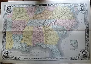
Map of the Southern States, Including Rail Roads, County Towns, State Capitals, County Roads, the Southern Coast from Delaware to Texas, Showing the Harbors, Inlets, Forts and Position of Blockading Ships
Idioma: Inglés
Publicado por Harpers, New York, 1886
Librería: Old Paper Old Ink, Murray, KY, Estados Unidos de America
Calificación del vendedor: 4 de 5 estrellas
Mapa
EUR 88,94
Envío por EUR 4,51
Se envía dentro de Estados Unidos de AmericaCantidad disponible: 1 disponibles
Ańadir al carritoNo Binding. Condición: Fair. Harper's Weekly. Map of the Southern States, Including Rail Roads, County Towns, State Capitals, County Roads, the Southern Coast from Delaware to Texas, Showing the Harbors, Inlets, Forts and Position of Blockading Ships. Dated in plate Dec. 1863. *** Woodcut lithographed map with original hand coloring produced for HARPER'S PICTORIAL HISTORY OF THE CIVIL WAR, published in 1886, the actual date of printing for this map. A fancy map with decorative borders, a vignette portrait in each corner of an important person in the Civil War, and a small inset map of southern Florida. The verso has three woodcut lithographed maps of strategic areas. *** Clean, clear image with good color. Several folds, as issued. Some fold separations and numerous short margin tears repaired on verso with clear archival tape. Small loss at several spots along center vertical fold. Not too common because these maps are somewhat fragile and require careful handling. *** Image size is 19.75 inches high by 30 inches, sheet size is 22.25 inches high by 32.5 inches. 12/16/2012 eBay $35.00 # 1183.
-
![Imagen del vendedor de County Map of the State of Texas. Showing also portions of the Adjoining States and Territories [with inset] Plan of Galveston and Vicinity a la venta por Kaaterskill Books, ABAA/ILAB](https://pictures.abebooks.com/inventory/md/md31156937588.jpg)
County Map of the State of Texas. Showing also portions of the Adjoining States and Territories [with inset] Plan of Galveston and Vicinity
Idioma: Inglés
Publicado por [W.M. Bradley & Bro.], [Philadelphia], 1886
Librería: Kaaterskill Books, ABAA/ILAB, East Jewett, NY, Estados Unidos de America
Miembro de asociación: ABAA ILAB IOBA
Calificación del vendedor: 5 de 5 estrellas
EUR 177,97
Envío por EUR 6,05
Se envía dentro de Estados Unidos de AmericaCantidad disponible: 1 disponibles
Ańadir al carritoCondición: Very good, faint toning. Hand colored map. 21 x 14 inches. Plates 64 & 65: County map of the state of Texas. Showing also portions of the adjoining states and territories, (with inset) Plan of Galveston and vicinity. Copyright by S. Augustus Mitchell 1884. From: Mitchell's New General Atlas, Containing Maps Of The Various Countries Of The World, Plans Of Cities, Etc., Embraced In Ninety-Three Quarto Maps, Forming A Series Of One Hundred and Forty-seven Maps and Plans, Together With Valuable Statistical Tables. Also, A List Of Post-Offices Of The United States And Territories, And Also Census Of 1880 For States, Territories And Counties, Also Of Cities Of Over 10,000 Inhabitants. Philadelphia: Published By Wm. M. Bradley & Bro., No. 1026 Arch Street. 1886.
-

Map of Hartley County (Texas)
Publicado por Dalhart, Texas c.1960, Dalhart, Texas, 1960
Librería: High Ridge Books, Inc. - ABAA, South Deerfield, MA, Estados Unidos de America
Miembro de asociación: ABAA ESA ILAB SNEAB
Calificación del vendedor: 5 de 5 estrellas
EUR 66,74
Envío por EUR 7,86
Se envía dentro de Estados Unidos de AmericaCantidad disponible: 1 disponibles
Ańadir al carritoSmall plat map of a county in the northern Texas panhandle. Very good condition. Manuscript line shows the school district. Small insect holes in right margin. Block owners (drilling rights?) are shown, as are a small number of land owners.
-

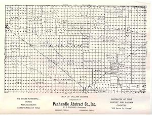
Map of Dallam County (Texas)
Publicado por Dalhart, Texas c.1950, Dalhart, Texas, 1950
Librería: High Ridge Books, Inc. - ABAA, South Deerfield, MA, Estados Unidos de America
Miembro de asociación: ABAA ESA ILAB SNEAB
Calificación del vendedor: 5 de 5 estrellas
EUR 66,74
Envío por EUR 7,86
Se envía dentro de Estados Unidos de AmericaCantidad disponible: 1 disponibles
Ańadir al carritoSmall plat map of the northwesternmost county in Texas. Some manuscript markings, vertical creasing. Block owners (drilling rights?) are shown, as are a small number of land owners.
-
Map of Dallam County (Texas)
Publicado por Dalhart, Texas c.1960, Dalhart, Texas, 1960
Librería: High Ridge Books, Inc. - ABAA, South Deerfield, MA, Estados Unidos de America
Miembro de asociación: ABAA ESA ILAB SNEAB
Calificación del vendedor: 5 de 5 estrellas
EUR 66,74
Envío por EUR 7,86
Se envía dentro de Estados Unidos de AmericaCantidad disponible: 1 disponibles
Ańadir al carritoSmall plat map of the northwesternmost county in Texas. fine condition. Block owners (drilling rights?) are shown, as are a small number of land owners.
-

Map of Dallam County (Texas)
Publicado por Dalhart, Texas c.1949, Dalhart, Texas, 1949
Librería: High Ridge Books, Inc. - ABAA, South Deerfield, MA, Estados Unidos de America
Miembro de asociación: ABAA ESA ILAB SNEAB
Calificación del vendedor: 5 de 5 estrellas
EUR 66,74
Envío por EUR 7,86
Se envía dentro de Estados Unidos de AmericaCantidad disponible: 1 disponibles
Ańadir al carritoSmall plat map of the northwesternmost county in Texas. Some manuscript markings show school district lines for the 1949-50 school year. Block owners (drilling rights?) are shown, as are a small number of land owners.
-

Map of Wheeler County, Texas
Publicado por Amarillo, Texas c.1950, Amarillo, Texas, 1950
Librería: High Ridge Books, Inc. - ABAA, South Deerfield, MA, Estados Unidos de America
Miembro de asociación: ABAA ESA ILAB SNEAB
Calificación del vendedor: 5 de 5 estrellas
EUR 66,74
Envío por EUR 7,86
Se envía dentro de Estados Unidos de AmericaCantidad disponible: 1 disponibles
Ańadir al carritoPlat map of a county in the Texas panhandle, with some manuscript color designating school districts. Fair condition, with insect damage resulting in some loss. Some land and drilling rights owners identified.
-

County Map of Texas and Indian Territory on verso- County Map of Alabama, Mississippi, Arkansas and Louisiana
Publicado por Stewart, D. J., Philadelphia, 1875
Librería: mediumraremaps.com, Franklin, TN, Estados Unidos de America
Calificación del vendedor: 5 de 5 estrellas
Mapa
EUR 200,21
Envío por EUR 5,18
Se envía dentro de Estados Unidos de AmericaCantidad disponible: 2 disponibles
Ańadir al carrito12 1/2 x 15 1/2 inches. Stewart, D. J. Ilustrador. 1875. Superb map of Texas from the Atlas of McComb County, MI, 1875. Maps from this source of D.J. Stewart are quite rare. This image speaks for itself. Very good- Several small tears around the edges repaired with archival mending tape.
-
Rand, McNally & Co.'s Indexed Railroad and County Pocket Map Shippers Guide Texas
Publicado por RAND, McNALLY & COMPANY, Chicago, 1885
Librería: T. W. Palmer Books, Eugene, OR, Estados Unidos de America
Calificación del vendedor: 5 de 5 estrellas
EUR 444,92
Envío por EUR 3,46
Se envía dentro de Estados Unidos de AmericaCantidad disponible: 1 disponibles
Ańadir al carritoHardcover. Condición: Good. 17 x 10.5 cm., 55pp., text, plus 2 folding colored maps, one attached and one loose,(substantial tears on loose map on fold lines), booklet is bound but front hinge is separating.
-
[Texas Agriculture] Johnson Hecht Co. Cotton - Onion - Citrus - Lands Raymondsville, TX [map plus printed ephemera:] Raymondville, Willacy County, Texas. Rio Grande Valley.
Publicado por Johnson Hecht Co., 1926
Librería: Barry Lawrence Ruderman, La Jolla, CA, Estados Unidos de America
Miembro de asociación: ABAA ILAB
Calificación del vendedor: 5 de 5 estrellas
EUR 511,66
Envío por EUR 12,53
Se envía dentro de Estados Unidos de AmericaCantidad disponible: 1 disponibles
Ańadir al carritoHardcover. Condición: VG. Promotional brochure and map for Raymondville, Wallacy County, Texas. The folding brochure emphasizes agricultural potential in cotton, onion, citruis fruits, and chicken raising, with numerous views. Mimeograph map of south Texas + printed pictorial brochure and 3 pages of typed carbon letters, signed by A.K. Johnson, with original mailing envelope. Condition is clean and nice. Promotional brochure and map for Raymondville, Wallacy County, Texas. The folding brochure emphasizes agricultural potential in cotton, onion, citruis fruits, and chicken raising, with numerous views of Raymondville, in Wallacy County ("the baby County in Texas, being organized in 1922"). The map is a mimeograph printing of a hand-drawn map showing the Texas - Mexico border area near Brownsville, including Padre Island, with an emphasis on the small towns scattered among this agricultural region of South Texas: San Benito, Harlingen, Sebastian, Lyford, Raymondsville [also Raymondville], La Sara, Hargill, Edinburg, Mission, McAllen, San Juan, Donna, Weslaco, Mercedes, and the like. The typed letter on Johnson-Hect Company letterhead is dated Dec. 21, 1926, and metions a new railroad being built from Raymondville "North and East." The other letter sheet is on St. George Hotel letterhead (Charles Hodges, Proprietor), dated Jan. 13, 1927 though not signed, and mentions "an Italian gentleman" who is "well connected in the City of New York with his countrymen there, who have money and want to come South. and he is a very live wire." Charles R. Johnson was a central figure in the early 20th-century development of Willacy County and surrounding areas in South Texas, combining his roles as publisher of the Willacy County News, land promoter, and later public official. In partnership with W. G. Hecht through the Johnson-Hecht Company, he marketed irrigated farm tracts around Raymondville and produced promotional maps highlighting cotton, onion, and citrus lands, while also helping to lay out the planned town of San Perlita in 1926 with his wife Pyrle providing the landscaping. Johnson went on to serve as Willacy County judge in the late 1930s, mayor of Raymondville in the late 1940s, and was a driving force behind the creation of the Willacy County Navigation District in 1948, which led to the founding of Port Mansfield and the dredging of the Mansfield Cut. His career illustrates the link between private land colonization schemes and public infrastructure development in the Lower Rio Grande Valley. Book.
-
Rand, McNally & Co.'s Indexed Railroad and County Map and Shipers' Guide of Texas
Publicado por Rand McNally & Company, Chicago, Illinois, 1882
Librería: T. W. Palmer Books, Eugene, OR, Estados Unidos de America
Calificación del vendedor: 5 de 5 estrellas
EUR 1.779,68
Envío por EUR 3,46
Se envía dentro de Estados Unidos de AmericaCantidad disponible: 2 disponibles
Ańadir al carritoHardcover. Condición: Very Good. No Jacket. 16.5 x 10.5 cm, 57, [3 pages advertisements] pp., includes list of 32 railroads, list of counties with area and 1880 census population, lists of creeks, islands, towns etc. Map 64 x 76 cm to neat lines, color lithography, extremely detailed with emphasis on railroads. booklet in very good condition with separation at inside front hinge. Map is on fragile paper with separations at a number of folds, but absolutely complete (should be laid down on linen). In original blind stamped brown folder with bright gilt lettering and near fine condition except for one bumped corner.
-
Rand, McNally & Co.'s Indexed County and Township map of Texas with a new and original compilation and index. of all Railroads in the State,. Counties, Lakes, Rivers
Publicado por Chicago: Rand, McNally & Co., 1882., 1882
Librería: Arader Galleries - AraderNYC, New York, NY, Estados Unidos de America
Calificación del vendedor: 5 de 5 estrellas
EUR 3.381,40
Gastos de envío gratis
Se envía dentro de Estados Unidos de AmericaCantidad disponible: 1 disponibles
Ańadir al carritoHardcover. 8vo., (6 6/8 x 4 inches). Fine folding chromolithographed map (25 x 28 4/8 inches to the neat-line). Original maroon cloth, gilt. A fine large scale map of Texas. Catalogued by Kate Hunter at Arader Galleries.
-
Map of the Southern States, Including Rail Roads, County Towns, State Capitals, County Roads, the Southern Coast from Delaware to Texas, Showing the Harbors, Inlets, Forts and Position of Blockcading Ships
Publicado por Star Publishing Company, Chicago, 1894
Librería: Peninsula Books, Traverse City, MI, Estados Unidos de America
Calificación del vendedor: 5 de 5 estrellas
Mapa
EUR 88,94
Envío por EUR 6,13
Se envía dentro de Estados Unidos de AmericaCantidad disponible: 1 disponibles
Ańadir al carritoMap. Condición: Good. Estado de la sobrecubierta: No Dust Jacket. This color map of the southern states during the civil war originally appeared in Harper's magazine and was later issued in their 2 volume History of the Civil War. This map was included in the 1894 reprint of "Harper's History of the Civil War" (which was originally published in 1866). It is a large single sheet and is folded four times, as issued. Star Publishing republished the 2 volume set in a series of weekly issues, and the subscriber then had the option of binding the weekly issues into two large volumes. This sheet measures 22.5" x 32.5" and was probably contained in one of the earlier issues of the series as the verso of the map has pages from the history included (pp. 125, 128, 129, 132) There is some marginal wear to the edges of the map which does not intrude into the image (except very slightly into the edge decoration at one tear and a small tear at the center of the folds from refolding). At the bottom of the map: "Prepared for Harper's Pictorial History of the Civil War, December 1863." (The map was originally issued in b&w in Harper's Weekly in 1861, and then issued by Harper's in a colored edition two years later.) The map has black decorative borders with round portraits of Abraham Lincoln, William H. Seward, George B. McClellan, and Winfield Scott at the corners. There is also an inset of the tip the Florida peninsula. ; Color Map; Single Sheet pages.
-
Report Card from Big Creek School in Fort Bend County, Texas 1913-1914: Rare Ephemera from a Settlement Long Gone from the Map (if it was ever on one)
Publicado por Coaster Print, Richmond, Texas, 1914
Librería: Whiting Books, Fulshear, TX, Estados Unidos de America
Miembro de asociación: IOBA TXBA
Calificación del vendedor: 5 de 5 estrellas
EUR 66,74
Envío por EUR 5,14
Se envía dentro de Estados Unidos de AmericaCantidad disponible: 1 disponibles
Ańadir al carritoNo Binding. Condición: Good. Old report card from a school in Fort Bend County, Texas for a 3rd grade student (Russell Brumbelow). The School is named Big Creek, but we cannot find any mention of this school in county histories or on the Internet and only a few references to Big Creek, the community. Big Creek, the waterway, starts south of Rosenberg and runs some 25 miles southeast to the Brazos River. The school was likely in that part of the county, perhaps in the Fairchilds area. Edward Risinger is listed as Superintendent. Coaster Print in Richmond, Texas printed the report card. Big Creek, the community, did exist, as evidenced by the existence of a post office as early as 1846 and record of its discontinuance in 1867. This report card offers evidence that the settlement was still recognized by 1914. Oil was discovered at Big Creek in 1922. Finding an old map with Big Creek on it has been difficult (none yet). The folded report card measures 3 3/4 X 6 1/4 inches. Well-preserved, though browned with age, it offers advice to parents, instructions to teachers, and a few inspirational quotes. The student was graded in the subjects of Reading, Spelling, Writing, Arithmetic, Grammar, and Geography. He did quite well!
-

County Map of Texas
Publicado por S. Augustus Mitchell, Jr., New York, 1860
Librería: Main Street Fine Books & Mss, ABAA, Galena, IL, Estados Unidos de America
Miembro de asociación: ABAA ILAB MWABA
Calificación del vendedor: 5 de 5 estrellas
Mapa
EUR 177,97
Envío por EUR 5,18
Se envía dentro de Estados Unidos de AmericaCantidad disponible: 1 disponibles
Ańadir al carritoFolio (15Ľ" X 12Ľ", image area 13Ľ" X 10 3/4"). Hand colored. Very good. Light age toning. Nicely, boldly colored map of this oversize state, from the 1864 edition of "Mitchell's New General Atlas, Containing Maps of the Various Countries of the World, Plans of Cities, Etc." Inset at lower left shows "Galveston Bay and Vicinity," and the large Native American turf "Young Territory" and "Bexar Territory" are properly outlined. Attractively colored, with bold decorative border.


![Imagen del vendedor de [Texas Agriculture] Johnson Hecht Co. Cotton - Onion - Citrus - Lands Raymondsville, TX [map plus printed ephemera:] Raymondville, Willacy County, Texas. Rio Grande Valley. a la venta por Barry Lawrence Ruderman](https://pictures.abebooks.com/inventory/md/md32275227633.jpg)