

Importe total (1 artículo artículos):
Destino del pedido:

paula gestel (15 resultados)
Ir a los resultados principales
Filtros de búsqueda
Tipo de artículo
- Todos los tipos de productos
- Libros (15)
- Revistas y publicaciones (No hay ningún otro resultado que coincida con este filtro.)
- Cómics (No hay ningún otro resultado que coincida con este filtro.)
- Partituras (No hay ningún otro resultado que coincida con este filtro.)
- Arte, grabados y pósters (No hay ningún otro resultado que coincida con este filtro.)
- Fotografías (No hay ningún otro resultado que coincida con este filtro.)
- Mapas (No hay ningún otro resultado que coincida con este filtro.)
- Manuscritos y coleccionismo de papel (No hay ningún otro resultado que coincida con este filtro.)
Condición Más información
- Nuevo (6)
- Como nuevo, Excelente o Muy bueno (3)
- Bueno o Aceptable (2)
- Regular o Pobre (No hay ningún otro resultado que coincida con este filtro.)
- Tal como se indica (4)
Encuadernación
- Todas
- Tapa dura (15)
- Tapa blanda (No hay ningún otro resultado que coincida con este filtro.)
Más atributos
- Primera edición (1)
- Firmado (No hay ningún otro resultado que coincida con este filtro.)
- Sobrecubierta (4)
- Con imágenes (2)
- No impresión bajo demanda (15)
Idioma (3)
Precio
- Cualquier precio
- Menos de EUR 20 (No hay ningún otro resultado que coincida con este filtro.)
- EUR 20 a EUR 45 (No hay ningún otro resultado que coincida con este filtro.)
- Más de EUR 45
Gastos de envío gratis
- Envío gratis a Estados Unidos de America (No hay ningún otro resultado que coincida con este filtro.)
Ubicación del vendedor
Valoración de los vendedores
-
![Imagen del vendedor de Mappae Antiquae. [ NEW COPY Still shrinkwrapped !] Liber Amicorum Günter Schilder. Vriendenboek ter gelegenheid van zijn 65ste verjaardag - Essays on the occasion of his 65th birthday - Festschrift zur Vollendung seines 65. Lebensjahr - Melanges offerts pour son 65ième anniversaire. [2 Volumes in original slipcase] a la venta por Frans Melk Antiquariaat](https://pictures.abebooks.com/inventory/md/md8869228696.jpg)
Mappae Antiquae. [ NEW COPY Still shrinkwrapped !] Liber Amicorum Günter Schilder. Vriendenboek ter gelegenheid van zijn 65ste verjaardag - Essays on the occasion of his 65th birthday - Festschrift zur Vollendung seines 65. Lebensjahr - Melanges offerts pour son 65ième anniversaire. [2 Volumes in original slipcase]
Idioma: Inglés
Publicado por Hes & de Graaf Publishers, 2007
ISBN 10: 9061944791 ISBN 13: 9789061944799
Librería: Frans Melk Antiquariaat, HILVERSUM, Holanda
Calificación del vendedor: 5 de 5 estrellas

EUR 60,00
Envío por EUR 68,00
Se envía de Holanda a Estados Unidos de AmericaCantidad disponible: 1 disponibles
Añadir al carrito't Goy-Houten, HES & De Graaf Publishers, 2007. 32 x 24 cm. 2 Hardcovers (gilt blue clothbound). In original decorated slipcase. Volume I: text + illustrations in b/w and color, 696 pages; Volume 2: 15 folding maps. ISBN: 9789061944799 Volume 6: Utrechtse Historisch-Kartografische Studies / Utrecht Studies of the History of Cartography. NEW COPY Still shrinkwrapped * Oorspronkelijke prijs bij verschijnen: 159 euro / Previously published for 159 euro. Very heavy item that needs extra shipping charge! [Literatuur / Later [Nederlandse Literatuur] Cartografie / Cartography ].
-

Maps in Books of Russia and Poland. Published in the Netherlands to 1800.
Idioma: Inglés
Publicado por t Goy-Houten, HES & De Graaf Publishers. 2011, 2011
ISBN 10: 9061944406 ISBN 13: 9789061944409
Librería: Antiquariaat Schot, Hendrik-Ido-Ambacht, Holanda
Calificación del vendedor: 5 de 5 estrellas
EUR 109,25
Envío por EUR 25,00
Se envía de Holanda a Estados Unidos de AmericaCantidad disponible: 2 disponibles
Añadir al carritoOriginal publisher's red cloth hardback, gilt title spine and frontcover, pictorial dustjacket, thick large 4to: title-page illustration, 724pp., ca. 700 plates & illustrations, introduction - 8 essays with illustrations - notes & references, summary in Dutch, conclusion, Russian summary, Polish summary, CATALOGUE of over 700 maps depicted & described with notes & references, photo credits, list consulted libraries, general bibliography, index personal names, index place names, curriculum viæ. Large folding view Moskow in rear pocket. Fine copy. Volume 13: Books in Utrechtse Historisch-Kartografische Studies / Utrecht Studies of the History of Cartography.
-

Atlas Amicorum Peter van der Krogt
Librería: Brook Bookstore, Milano, MI, Italia
Calificación del vendedor: 5 de 5 estrellas
EUR 167,10
Envío por EUR 47,49
Se envía de Italia a Estados Unidos de AmericaCantidad disponible: Más de 20 disponibles
Añadir al carritoCondición: new.
-

Mapp antiqu Liber Amicorum Gnter Schilder 2 Vols
Idioma: Inglés
Publicado por Brill | Hes & De Graaf, 2007
ISBN 10: 9061944791 ISBN 13: 9789061944799
Librería: Brook Bookstore, Milano, MI, Italia
Calificación del vendedor: 5 de 5 estrellas
EUR 196,58
Envío por EUR 66,49
Se envía de Italia a Estados Unidos de AmericaCantidad disponible: 5 disponibles
Añadir al carritoCondición: new.
-
Atlas Amicorum Peter Van Der Krogt
Librería: Revaluation Books, Exeter, Reino Unido
Calificación del vendedor: 5 de 5 estrellas
EUR 258,83
Envío por EUR 23,52
Se envía de Reino Unido a Estados Unidos de AmericaCantidad disponible: 1 disponibles
Añadir al carritoHardcover. Condición: Brand New. bilingual edition. 500 pages. Dutch language. 12.25x9.50x1.50 inches. In Stock.
-
Mappae Antiquae: Liber Amicorum Gunter Schilder (Utrecht Studies in the History of Cartography) (Utrechtse Historisch-Cartografische Studies/Utrecht Studies in the History of Cartography)
Idioma: Inglés
Publicado por Hes & De Graff Pub B V, 2007
ISBN 10: 9061944791 ISBN 13: 9789061944799
Librería: Revaluation Books, Exeter, Reino Unido
Calificación del vendedor: 5 de 5 estrellas
EUR 306,38
Envío por EUR 35,28
Se envía de Reino Unido a Estados Unidos de AmericaCantidad disponible: 1 disponibles
Añadir al carritoHardcover. Condición: Brand New. bilingual edition. 696 pages. Dutch language. 12.25x9.25x3.50 inches. In Stock.
-

Mappae Antiquae: Liber Amicorum Günter Schilder
Publicado por Hes & De Graaf Publishers, 2007
Librería: Arader Galleries of Philadelphia, PA, Philadelphia, PA, Estados Unidos de America
Calificación del vendedor: 5 de 5 estrellas
EUR 90,05
Envío por EUR 3,93
Se envía dentro de Estados Unidos de AmericaCantidad disponible: 1 disponibles
Añadir al carritoHardcover. Condición: As New. Includes two-volume set of the text and accompanying maps. Original Gilt spine and front cover. Written in Dutch with some portions translated to English. In like new condition. Original slipcase in excellent c.
-
Mappae Antiquae: Liber Amicorum Günter Schilder
Publicado por Hes & De Graaf Publishers, 2007
Librería: Arader Galleries of Philadelphia, PA, Philadelphia, PA, Estados Unidos de America
Calificación del vendedor: 5 de 5 estrellas
EUR 90,05
Envío por EUR 3,93
Se envía dentro de Estados Unidos de AmericaCantidad disponible: 1 disponibles
Añadir al carritoHardcover. Condición: As New. Includes two-volume set of the text and accompanying maps. Original Gilt spine and front cover. Written in Dutch with some portions translated to English. In like new condition. Original slipcase in excellent c.
-
Mappæ antiquæ: Liber Amicorum Günter Schilder (2 Vol set) Essays on the Occasion of his 65th Birthday(Utrecht Studies in the History of Cartography / Utrechtse Hi) (Dutch and English Edition)
Librería: Red-books ( Member of P.B.F.A. ), Hanley Swan, Reino Unido
Miembro de asociación: PBFA
Calificación del vendedor: 5 de 5 estrellas
Original o primera edición
EUR 123,54
Envío por EUR 16,46
Se envía de Reino Unido a Estados Unidos de AmericaCantidad disponible: 1 disponibles
Añadir al carritoHardcover. Condición: Very Good. First Edition. Two volume set in slip case which appears to have no significant wear. Volume one is a series of articles relating to cartography some of which are in English but also in German, French and Dutch. There are numerous excellent illustations. Volume two contains fifteen folded facsimile maps which open out to approx 42cm by 52cm. Both volumes appear to be in mint unread condition. Happy to supply photos on request. Very heavy set, no additional postage in the UK. Please inquire for postage outside the UK.
-
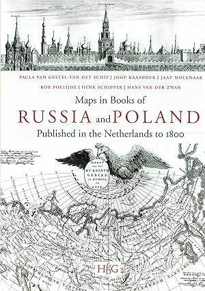
Maps in books on Russia and Poland Published in the Netherlands to 1800.
Publicado por HES & DE GRAAF Houten, 2011
Librería: Shapero Rare Books, London, Reino Unido
Miembro de asociación: ABA ILAB PBFA
Calificación del vendedor: 5 de 5 estrellas
EUR 181,68
Envío por EUR 17,64
Se envía de Reino Unido a Estados Unidos de AmericaCantidad disponible: 1 disponibles
Añadir al carritoSize: 32 x 24. Binding: Cloth with full colour dust jacket. Illustration: ca. 700. Pages: 750. A new reference book on Russian and Polish cartography - very detailed and richly illustrated. The decision to embark on researching maps in books has resulted in a publication, presenting an unique combination of maps, plans and views. It concerns those, tucked away in historical and geographical works on Russia and Poland, prior to 1800 and published in the Netherlands. Both maps and books are elaborately described, analysed and indexed; much attention has been lavished on their authors, engravers and publishers to boot. The cartographic subdivision of the maps according to their regions brings to light the specific interrelation between the various works by differing authors. The comprehensive introduction describes the history of Russia and Poland from various points of view for specific subjects and comes richly illustrated with over 100 images. The cartobibliography contains illustrations for each of the over 700 maps described and the bibliography features a large number of title pages and portraits in addition. This unusual combination of research objectives should appeal to map and book historians and collectors alike. A large folding view of the city of Moscow (30 x 185 cm.) by Cornelis de Bruijn (1711) has been added in facsimile at the back of this publication. Summaries in Russian and Polish complete this publication. In English with Polish and Russian summary. Maps in books of Russia and Poland is part 13 of the Utrecht Studies on the History of Cartography (Explokart).
-

Evert Maaskamp (1769-1834) Amsterdams kaart- en boekenuitgever in roerige tijden Bram Vannieuwenhuyze (Redacteur), Marissa Griffioen (Redacteur), Anne-Rieke van Schaik (Redacteur)
Librería: BUCHSERVICE / ANTIQUARIAT Lars Lutzer, Wahlstedt, Alemania
Calificación del vendedor: 5 de 5 estrellas
EUR 179,00
Envío por EUR 39,95
Se envía de Alemania a Estados Unidos de AmericaCantidad disponible: 1 disponibles
Añadir al carritoCondición: gut. Evert Maaskamp (1769-1834) Amsterdams kaart- en boekenuitgever in roerige tijden In deutscher Sprache. pages.
-

Kaarten Van De Nederlandse Antillen: Curaçao, Aruba, Bonaire, Saba, Sint Eustatius En Sint Maarten Tot 1900
Idioma: Holandés
Publicado por Hes & De Graff Pub B V, 2016
ISBN 10: 9004301550 ISBN 13: 9789004301559
Librería: Revaluation Books, Exeter, Reino Unido
Calificación del vendedor: 5 de 5 estrellas
EUR 200,84
Envío por EUR 35,28
Se envía de Reino Unido a Estados Unidos de AmericaCantidad disponible: 1 disponibles
Añadir al carritoHardcover. Condición: Brand New. bilingual edition. 664 pages. Dutch language. 12.25x9.50x1.75 inches. In Stock.
-
Kaarten van de Nederlandse Antillen
Idioma: Holandés
Publicado por Brill - Hes & de Graaf, 2016
ISBN 10: 9004301550 ISBN 13: 9789004301559
Librería: Brook Bookstore, Milano, MI, Italia
Calificación del vendedor: 5 de 5 estrellas
EUR 165,36
Envío por EUR 66,49
Se envía de Italia a Estados Unidos de AmericaCantidad disponible: Más de 20 disponibles
Añadir al carritoCondición: new.
-
Kaarten Van de Nederlandse Antillen : Curaçao, Aruba, Bonaire, Saba, Sint Eustatius En Sint Maarten Tot 1900
Librería: Buchpark, Trebbin, Alemania
Calificación del vendedor: 5 de 5 estrellas
EUR 138,68
Envío por EUR 105,00
Se envía de Alemania a Estados Unidos de AmericaCantidad disponible: 1 disponibles
Añadir al carritoCondición: Sehr gut. Zustand: Sehr gut | Seiten: 664 | Sprache: Niederländisch | Produktart: Bücher | Dit rijk geïllustreerde onderzoek naar kaarten van de Nederlandse Antillen, zowel in manuscript als gedrukt, geeft een zo volledig mogelijk overzicht van de grote variatie aan kaarten die van dit gebied in Nederland zijn vervaardigd. De kaartbeschrijvingen worden toegelicht met informatie over de makers van de kaarten en de historische achtergronden van het kaartbeeld. De auteur heeft zich uitvoerig verdiept in de wijze waarop en de redenen waarom deze kaarten tot stand zijn gekomen. De cartobibliografie wordt voorafgegaan door een uitgebreide inleiding waarin de geschiedenis van deze eilanden en hun bewoners wordt beschreven.Dr. W.E. (Wim) Renkema (1942) studeerde geschiedenis en sociale geografie aan de Vrije Universiteit Amsterdam. Hij was werkzaam in het voortgezet onderwijs en promoveerde in 1981 op een proefschrift over het Curaçaose plantagebedrijf in de negentiende eeuw. Sindsdien publiceerde hij verschillende artikelen over de Curaçaose geschiedenis en een boek over gouverneur R.F. van Raders, Een leven in de West: Van Raders en zijn werkzaamheden op Curaçao (Brill, 2009).
-
Mappae Antiquae. Liber Amicorum Günter Schilder. Vriendenboek ter gelegenheid van zijn 65ste verjaardag. / Essays on the occasion of his 65th birthday. / Festschrift zur Vollendung seines 65. Lebensjahr. / Melanges offerts pour son 65ième anniversaire.
Librería: Antiquariaat A. Kok & Zn. B.V., Amsterdam, Holanda
Miembro de asociación: ILAB NVVA
Calificación del vendedor: 5 de 5 estrellas
EUR 71,50
Envío por EUR 28,27
Se envía de Holanda a Estados Unidos de AmericaCantidad disponible: 1 disponibles
Añadir al carrito't Goy, HES & De Graaf, [2007]. 2 vols (text & plates). 696 pp. Col. & b./w. ills. Orig. hardcover (blue cloth with gilt lettering). 4to. (= text vol.). + 15 large loose fold. b./w. facsimile plts in uniform portfolio. Together in orig slipcase. (Utrechtse Historisch-Kartografische Studies / Utrecht Studies of the History of Cartography, Vol. 6). [ ISBN: 9789061944799].Complete set of two volumes. Contributions in Dutch, French, German & English. - The 15 loose plates together form two full-scale facsimiles: (1) Bird's-eye view of Vienna from the north, by Jacob Hoefnagel, published by Caes. Jansz. Visscher, Amsterdam, 1640; (2) Bird's-eye view of Vienna from the west, by Folbert van Ouden-Allen, engraved by Joseph Mulder, 1686.

