
Importe total (1 artículo artículos):
Destino del pedido:

matth seutter (23 resultados)
Ir a los resultados principales
Filtros de búsqueda
Tipo de artículo
- Todos los tipos de productos
- Libros (13)
- Revistas y publicaciones (No hay ningún otro resultado que coincida con este filtro.)
- Cómics (No hay ningún otro resultado que coincida con este filtro.)
- Partituras (No hay ningún otro resultado que coincida con este filtro.)
- Arte, grabados y pósters (6)
- Fotografías (No hay ningún otro resultado que coincida con este filtro.)
- Mapas (4)
- Manuscritos y coleccionismo de papel (No hay ningún otro resultado que coincida con este filtro.)
Condición Más información
- Nuevo (No hay ningún otro resultado que coincida con este filtro.)
- Como nuevo, Excelente o Muy bueno (1)
- Bueno o Aceptable (2)
- Regular o Pobre (No hay ningún otro resultado que coincida con este filtro.)
- Tal como se indica (20)
Encuadernación
- Todas
- Tapa dura (No hay ningún otro resultado que coincida con este filtro.)
- Tapa blanda (No hay ningún otro resultado que coincida con este filtro.)
Más atributos
- Primera edición (No hay ningún otro resultado que coincida con este filtro.)
- Firmado (No hay ningún otro resultado que coincida con este filtro.)
- Sobrecubierta (No hay ningún otro resultado que coincida con este filtro.)
- Con imágenes (18)
- No impresión bajo demanda (23)
Idioma (3)
Precio
- Cualquier precio
- Menos de EUR 20 (No hay ningún otro resultado que coincida con este filtro.)
- EUR 20 a EUR 45 (No hay ningún otro resultado que coincida con este filtro.)
- Más de EUR 45
Gastos de envío gratis
- Envío gratis a Estados Unidos de America (No hay ningún otro resultado que coincida con este filtro.)
Ubicación del vendedor
Valoración de los vendedores
-

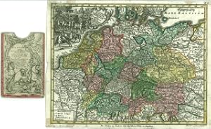
Electoratus sive Marchia Brandenburgensis accurate aeri ineisa opera et Sumptibus Matthaei Seutteri, S.C.M. Geogr. Aug. Vind. Electoratus sive Marchia Brandenburgensis accurate aeri ineisa opera et Sumptibus Matthaei Seutteri, S.C.M. Geogr. Aug. Vind. - Matth us Seutter ? Hand-Color.
Publicado por G. C. Lotter 1756-60, Augsburg, 1756
Librería: Antiquariat Reinhold Berg eK Inh. R.Berg, Regensburg, Alemania
Miembro de asociación: ILAB VDA
Calificación del vendedor: 5 de 5 estrellas

Mapa
EUR 145,00
Envío por EUR 24,00
Se envía de Alemania a Estados Unidos de AmericaCantidad disponible: 1 disponibles
Ańadir al carritoOther. Hand-Colored Original Copperplate Engraving by Matth us Seutter, depicting Electoratus sive Marchia Brandenburgensis accurate aeri ineisa opera et Sumptibus Matthaei Seutteri, S.C.M. Geogr. Aug. Vind. Published Augsburg, G. C. Lotter, 1756. Sheet: 195 by 253mm (7 by 10 inches). A fine and original hand-colored example of Seutter's celebrated cartographic work, documenting this region of Germany with the precision and decorative artistry characteristic of the 17500s. Matthaus Seutter (1678-1757) was one of the most prolific German cartographers of the 18th century, based in Augsburg. He trained as an engraver under Johann Baptist Homann in Nuremberg before establishing his own publishing firm in Augsburg around 1717. His skill and output were so impressive that Holy Roman Emperor Charles VI appointed him Imperial Geographer in 1732 -- a title he shared with his former master Homann. Seutter produced over 500 maps during his career, known for their richly detailed cartouches, decorative borders, and brilliant hand coloring. His work is held in collections at the Augsburg City Library, the Staatsbibliothek Berlin, and major museums across Europe.This original copperplate engraving, with original hand coloring depicts the region of Electoratus sive Marchia Brandenburgensis accurate aeri ineisa opera et Sumptibus Matthaei Seutteri, S.C.M. Geogr. Aug. Vind., published in Augsburg, G. C. Lotter, 1756-60. The map records the political and geographic boundaries of the region as understood in 1756-60, offering a fascinating window into the history of German territorial organization. Sheet measures 195 by 253mm (7 by 10 inches). In good condition overall, with minor signs of age appropriate for a 18th-century engraving. Ready to frame. In excellent condition. 195 by 253mm (7 by 10 inches). 195 by 253mm (7 by 10 inches).
-

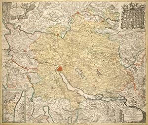
Marchionatus Lusatiae Inferioris Bohemiae olim Regno jam Elect. Saxoniae subject, in Circulos, Dynastias et Praefect: accuratissime distinctus, calamo et sumtibus Matth. Seutteri S.C.Maj. Geographi Aug. Vindel. Marchionatus Lusatiae Inferioris Bohemiae olim Regno jam Elect. Saxoniae subject, in Circulos, Dynastias et Praefect: accuratissime distinctus, calamo et sum.
Publicado por Matthaeus Seutter 1720-30, Augsburg, 1720
Librería: Antiquariat Reinhold Berg eK Inh. R.Berg, Regensburg, Alemania
Miembro de asociación: ILAB VDA
Calificación del vendedor: 5 de 5 estrellas
Mapa
EUR 220,00
Envío por EUR 24,00
Se envía de Alemania a Estados Unidos de AmericaCantidad disponible: 1 disponibles
Ańadir al carritoOther. Hand-Colored Original Copperplate Engraving by Matth us Seutter, depicting Marchionatus Lusatiae Inferioris Bohemiae olim Regno jam Elect. Saxoniae subject, in Circulos, Dynastias et Praefect: accuratissime distinctus, calamo et sumtibus Matth. Seutteri S.C.Maj. Geographi Aug. Vindel. Published Augsburg, Matthaeus Seutter, 1720. Sheet: 498 by 585mm (19 by 23 inches). A fine and original hand-colored example of Seutter's celebrated cartographic work, documenting this region of Germany with the precision and decorative artistry characteristic of the 17200s. Matthaus Seutter (1678-1757) was one of the most prolific German cartographers of the 18th century, based in Augsburg. He trained as an engraver under Johann Baptist Homann in Nuremberg before establishing his own publishing firm in Augsburg around 1717. His skill and output were so impressive that Holy Roman Emperor Charles VI appointed him Imperial Geographer in 1732 -- a title he shared with his former master Homann. Seutter produced over 500 maps during his career, known for their richly detailed cartouches, decorative borders, and brilliant hand coloring. His work is held in collections at the Augsburg City Library, the Staatsbibliothek Berlin, and major museums across Europe.This original copperplate engraving, with original hand coloring depicts the region of Marchionatus Lusatiae Inferioris Bohemiae olim Regno jam Elect. Saxoniae subject, in Circulos, Dynastias et Praefect: accuratissime distinctus, calamo et sumtibus Matth. Seutteri S.C.Maj. Geographi Aug. Vindel., published in Augsburg, Matthaeus Seutter, 1720-30. The map features a decorative Baroque cartouche containing the title inscription. The cartouche is elaborated with allegorical or figural ornamentation. The map records the political and geographic boundaries of the region as understood in 1720-30, offering a fascinating window into the history of German territorial organization. Sheet measures 498 by 585mm (19 by 23 inches). In good condition overall, with minor signs of age appropriate for a 18th-century engraving. Ready to frame. In excellent condition. 498 by 585mm (19 by 23 inches). 498 by 585mm (19 by 23 inches).
-

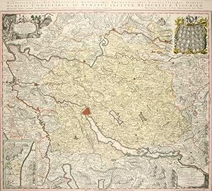
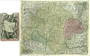
Marchionatus Brandenburgensis Ducatus Pomeraniae et Ducatus Mecklenburgicus excusi et venales prostantes apud Matthaeum Seutter, S.C.M.G. Augustan. Marchionatus Brandenburgensis Ducatus Pomeraniae et Ducatus Mecklenburgicus excusi et venales prostantes apud Matthaeum Seutter, S.C.M.G. Augustan. - Matth u.
Publicado por 1720/25, Augsburg, 1720
Librería: Antiquariat Reinhold Berg eK Inh. R.Berg, Regensburg, Alemania
Miembro de asociación: ILAB VDA
Calificación del vendedor: 5 de 5 estrellas
Mapa
EUR 245,00
Envío por EUR 24,00
Se envía de Alemania a Estados Unidos de AmericaCantidad disponible: 1 disponibles
Ańadir al carritoOther. Hand-Colored Original Etching by Matth us Seutter, depicting Marchionatus Brandenburgensis Ducatus Pomeraniae et Ducatus Mecklenburgicus excusi et venales prostantes apud Matthaeum Seutter, S.C.M.G. Augustan. Published Augsburg, 1720. Sheet: 500 by 585mm (19 by 23 inches). A fine and original hand-colored example of Seutter's celebrated cartographic work, documenting this region of Germany with the precision and decorative artistry characteristic of the 17200s. Matthaus Seutter (1678-1757) was one of the most prolific German cartographers of the 18th century, based in Augsburg. He trained as an engraver under Johann Baptist Homann in Nuremberg before establishing his own publishing firm in Augsburg around 1717. His skill and output were so impressive that Holy Roman Emperor Charles VI appointed him Imperial Geographer in 1732 -- a title he shared with his former master Homann. Seutter produced over 500 maps during his career, known for their richly detailed cartouches, decorative borders, and brilliant hand coloring. His work is held in collections at the Augsburg City Library, the Staatsbibliothek Berlin, and major museums across Europe.This original etching, with original hand coloring depicts the region of Marchionatus Brandenburgensis Ducatus Pomeraniae et Ducatus Mecklenburgicus excusi et venales prostantes apud Matthaeum Seutter, S.C.M.G. Augustan., published in Augsburg, 1720/25. The map features a decorative Baroque cartouche containing the title inscription. A distance scale is incorporated within the cartouche or alongside it. The cartouche is elaborated with allegorical or figural ornamentation. The map records the political and geographic boundaries of the region as understood in 1720/25, offering a fascinating window into the history of German territorial organization. Sheet measures 500 by 585mm (19 by 23 inches). In good condition overall, with minor signs of age appropriate for a 18th-century engraving. Ready to frame. A very well preserved copy. The map in a good equal impression. In decorative body color, as published. 500 by 585mm (19 by 23 inches).
-

La basse Autriche.
Publicado por Paris, le Rouge (1743)., 1743
Librería: Antiquariat Burgverlag, Wien, Austria
Miembro de asociación: ILAB VDA VDAO
Calificación del vendedor: 5 de 5 estrellas
EUR 275,00
Envío por EUR 65,00
Se envía de Austria a Estados Unidos de AmericaCantidad disponible: 1 disponibles
Ańadir al carritoAltkolor. Orig.-Kupferkarte gest. v. Tobias Conrad Lotter nach M. Seutter. 19,5 x 25 cm. (Bildausschn.) Unter säurefreiem Passepartout. Mit fig. Kartusche. Die Karte zeigt das Gebiet v. Ostösterr. Enns - Neusiedler See. Gewicht in Gramm: 500.
-
Archiducatus Austriae inferioris accuratißima tabula. Cujus ditio: in suos Quadr designatae.
Publicado por Augsburg o.J. (ca. 1740)., 1740
Librería: Antiquariat Burgverlag, Wien, Austria
Miembro de asociación: ILAB VDA VDAO
Calificación del vendedor: 5 de 5 estrellas
EUR 275,00
Envío por EUR 65,00
Se envía de Austria a Estados Unidos de AmericaCantidad disponible: 1 disponibles
Ańadir al carritoAltkolor. Orig.-Kupferkarte gest. v. Tobias Conrad Lotter. 19,5 x 25 cm. (Bildausschn.) Unter säurefreiem Passepartout. Mit fig. Kartusche. Die Karte zeigt das Gebiet v. Ostösterr. Enns - Neusiedler See. Gewicht in Gramm: 500.
-
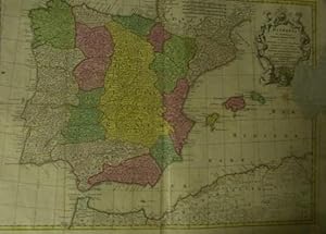
Hispania ex Archetypo Roderici Mendez Sylvae et variis Relationibus et Chartis manuscriptis et impressis huius Regni rectificatis per Observationes Sociorum Academiae Scientiarum quae est Parisiis.
Publicado por Lotter., Augsburg., 1730
Librería: Libreria M. T. Cicerone, Roma, RM, Italia
Calificación del vendedor: 4 de 5 estrellas

EUR 300,00
Envío por EUR 46,00
Se envía de Italia a Estados Unidos de AmericaCantidad disponible: 1 disponibles
Ańadir al carritoCarta geografica, cm.49,5 x 66,5 ca., a colori. Pregevole cartiglio in alto a destra. Mancanza di un lembo ( cm. 14 x 8 ca.) al marg. laterale des. con perdita di una piccola parte della carta e del cartiglio che tuttavia non influisce sulla consultabilitŕ della carta.
-
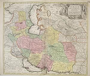
Opulentissimi Regni PERSIAE.Persia /Persien
Publicado por um 1740, Augsburg, 1740
Librería: Kunsthandlung Boschi, Innsbruck, Austria
Calificación del vendedor: 4 de 5 estrellas
EUR 420,00
Envío por EUR 30,00
Se envía de Austria a Estados Unidos de AmericaCantidad disponible: 1 disponibles
Ańadir al carritoSeutter, Matthaeus/ Seuttero Matth. / Seutteri Matthaei 1678 - 1757 Ilustrador. Kupferstich, altkoloriert, sehr schöne Landkarte von Persien, vom persischen Golf zum Kaspischen Meer, vom Schwarzen Meer bis Tibet/Indien, zeigt Iran, Irak, Afghanistan, Pakistan, Turkmenistan, Tadschikistan Usbekistan, Aserbaidschan, Georgien, Teile von Arabien, Kasachstan und Indien; very rare, decorative and originally coloured map, copper engraving of the Persian Empire, nice cartouche with figures in local costumes die Karte ist in einem guten Zustand, breiter Rand, unterhalb ist weniger Rand, Mittelfalte, center fold, good condition. Druckgrafik.
-
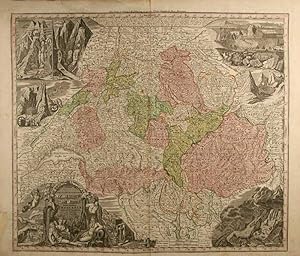
Nova Totius Helvetiae cum suis subditis. Schweiz. - Flächen- und grenzkolor. Kupferstichkarte. / Carte gravée originale de la Suisse.
Publicado por Augsburg, Seutter, o.J., um 1730., 1730
Librería: Harteveld Rare Books Ltd., Marly, Suiza
Miembro de asociación: ILAB VEBUKU
Calificación del vendedor: 4 de 5 estrellas
EUR 455,08
Envío por EUR 20,00
Se envía de Suiza a Estados Unidos de AmericaCantidad disponible: 1 disponibles
Ańadir al carrito54 : 63 cm (Blattformat) bzw. 49 : 57,5 cm (Kartenformat). Mit großer figürl. Kartusche mit allegor. Figuren des Rheins und anderer Flüsse, Wappen der Kantone, etc. in unt. lncker Ecke sowie Landschaftsszenen der Schweiz in den anderen drei Ecken. Mit Mittelfalz längs. 1 Blatt / 1 feuille. Die Karte koloriert in dezentem Rosa, Grün, Türkis, Orange und Gelb. Im Falzoben etwas ausgebessert, sonst sehr schönes Blatt.Please notify before visiting to see a book. Prices are excl. VAT/TVA (only Switzerland) & postage.
-
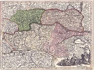
Carinthia Ducatus distincta in superiorem et inferior cum insertis Dominiis Ad Archiep. Salisurgens. et Episcop. Bambergensis pertinentibus nova mappa Geographica .
Publicado por Augsburg, Lotter [ca. 1730]., 1730
Librería: Antiquariat Burgverlag, Wien, Austria
Miembro de asociación: ILAB VDA VDAO
Calificación del vendedor: 5 de 5 estrellas
EUR 450,00
Envío por EUR 65,00
Se envía de Austria a Estados Unidos de AmericaCantidad disponible: 1 disponibles
Ańadir al carritoAltkolor. Kupferkarte. 53 x 62 cm. (Blattgr.), 49, 5 x 58, 5 cm (Plattengr.). Gerahmt. Bugfalte. Karte von Kärnten mit Teilen Steiermarks, Salzburgs, Tirols. Mit Textkartusche und schöner Gesamtansicht von Klagenfurt im ob. Teil. Gewicht in Gramm: 3000.
-
ATLAS MINOR PRAECIPUA ORBIS TERRARUM IMPERIA, REGNA ET PROVINCIAS, GERMANIAE POTISSIMUM, TABELLI 20 EXACTE DELINEATIS SISTENS USUI, MILITIAE DUCUM AC PEREGRINANTIUM MAXIME ACCOMODATUS OPERA
Publicado por casa editrice: LOTTERI anno: CIRCA 1740/50 citta': AUGSURG, 1740
Librería: libreria antiquaria e antichitŕ Onofri, Roma, RM, Italia
Calificación del vendedor: 5 de 5 estrellas
EUR 2.000,00
Envío por EUR 48,00
Se envía de Italia a Estados Unidos de AmericaCantidad disponible: 1 disponibles
Ańadir al carritoLEGATURA DEL '900 IN CARTONCINO, ATLANTE COMPLETO DELLE SUE 20 CARTE + IL FRONTESPIZIO. COLLAZIONATO. TUTTE LE CARTE SONO A COLORI D'EPOCA. ATLANTE MOLTO RARO numero pagine: 21 FOGLI formato: ALBUM 29.2X22.3 stato conservazione: MEDIOCRE, MANCANZE AI MARGINI, ALCUNI RESTAURATI, ALCUNE SCRITTE E LIEVI ALONI, MACCHIE AI VERSI DELLE TAVOLE, IL MARGINE DELLA TAVOLA DELL'ITALIA E' RIDOTTO NELLA PARTE SUPERIORE ED INFERIORE.
-

Nova et Accurata Hungariae Cum Adiacentib. Regn. et Principatibus Tabula
Publicado por Augsburg
Librería: Argosy Book Store, ABAA, ILAB, New York, NY, Estados Unidos de America
Miembro de asociación: ABAA ILAB
Calificación del vendedor: 5 de 5 estrellas
EUR 665,46
Envío por EUR 5,17
Se envía dentro de Estados Unidos de AmericaCantidad disponible: 1 disponibles
Ańadir al carritoMap. Hand colored engraving. 19 3/4" x 22 3/4". Fine antique map of Hungary and surrounding areas shown in just one configuration of the many possible snapshots of the 18th century border changes in the region. Depicted around 20 years following the second Battle of Mohacs which, through the end of the 17th century led to Transylvania becoming a part of Hungary again. By 1718, only a few years prior to this map, the entire Kingdom of Hungary had become removed from Ottoman rule. It was, however, still a part of the Habsburg Empire. The Balkans had also been relinquished to the Habsburg Empire by the Ottomans. An ornamental cartouche shows what is presumed to be a Hapsburg Ruler, either Joseph I, or Charles VI standing on an eagle. Bowing down to him are men holding the coats of arms of Dalmatia, Hungary, Croatia, Bosnia, Serbia, Transylvania, and Sclavonia, signifying their allegiance to the Habsburg Empire at this time. The map labels the larger country regions as well as counties within each country. Traditional topographical features such as mountains, forests, bodies of water, and castles are marked as well. Light abrasion in Sclavonia, otherwise in great condition. Matthaus Seutter the elder (1678-1757) was an engraver, globe maker and map publisher based in Augsburg. He apprenticed with J.B. Homann in Nuremberg and was awarded the title of Imperial Geographer by Karl VI in 1731. His son-in-law T.C. Lotter took over the business in 1758. This is a wonderful example of his work.
-
Karte von Zürich. Delineatio Pagi Tigurini. Carte en couleurs gravée par Conr. Lotter.
Publicado por Augsburg, ca. 1740,, 1740
Librería: Harteveld Rare Books Ltd., Marly, Suiza
Miembro de asociación: ILAB VEBUKU
Calificación del vendedor: 4 de 5 estrellas
EUR 975,15
Envío por EUR 20,00
Se envía de Suiza a Estados Unidos de AmericaCantidad disponible: 1 disponibles
Ańadir al carrito54.5x64.5 cm, Schöne, farbfrische Karte d. Kantons Zürich, auf festem Papier. Rechts oben die Wappen d. äusseren Vogteyen, links oben Cartouche mit Titel , unten links Nebenkarte mit Herrschaften Sax u. Forsteck, 1 Blatt / 1 feuille. Sehr schönes Exemplar, klarer und kräftiger Abdruck.Please notify before visiting to see a book. Prices are excl. VAT/TVA (only Switzerland) & postage. Ryhiner Sammlung N° 6269.
-
Karte von Zürich. Delineatio Pagi Tigurini. Carte en couleur gravé par Conr. Lotter.
Publicado por Augsburg, o.J. (um 1740-60),, 1740
Librería: Harteveld Rare Books Ltd., Marly, Suiza
Miembro de asociación: ILAB VEBUKU
Calificación del vendedor: 4 de 5 estrellas
EUR 975,15
Envío por EUR 20,00
Se envía de Suiza a Estados Unidos de AmericaCantidad disponible: 1 disponibles
Ańadir al carrito49.5x57.5 cm, Schöne farbfrische Karte d. Kantons Zürich, auf festem Papier. Kopfleiste mittel einer zusätzlichen Kupferplatte gedruckt, mit Widmung Mattaeus Seutter. Rechts oben die Wappen d. äusseren Vogteyen, links oben Cartuche mit Titel und unten eine Teilkarte der Enklave ?Werdenberg?, 1 Blatt / 1 feuille. 54.5x64.5 cm, Sehr schönes Exemplar, klarer und kräftiger Abdruck einer ungewöhnlichen Karte.Please notify before visiting to see a book. Prices are excl. VAT/TVA (only Switzerland) & postage. Ryhiner Sammlung 6269.
-
Delineatio geographica Praefecturarum Wittenbergensis et Graefenhaynichen.
Idioma: Alemán
Publicado por (1720)., 1720
Librería: Antiquariat Bücher & Graphik, Berlin, Alemania
Calificación del vendedor: 2 de 5 estrellas

EUR 250,00
Envío por EUR 19,85
Se envía de Alemania a Estados Unidos de AmericaCantidad disponible: 1 disponibles
Ańadir al carritoColor. Kupferstich m. 2 Kartuschen,. Angeschmutzt und kleine Randeinrisse. Sprache: Deutsch 58,3 x 50,0 cm im Passepartout.
-
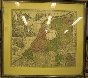
Belgium Foederatum auctius et emendatius edit . Kolorierte Kupferstichkarte von Belgien und den Niederlanden von Seutter. Mit einer Kartusche aus 6 Figuren und 2 Nebenkarten: "Limburgum Batavum"und "India oriental. .".
Idioma: Alemán
Publicado por Augsburg, Probst, um, 1730
Librería: Antiquariat im Schloss, Schwaigern, D, Alemania
Calificación del vendedor: 5 de 5 estrellas
Mapa
EUR 453,00
Envío por EUR 35,00
Se envía de Alemania a Estados Unidos de AmericaCantidad disponible: 1 disponibles
Ańadir al carritoFachmännisch gerahmt (Holzrahmen). Kupferstich in einwandfreiem Zustand. Passepartout unregelmäßig gegilbt, linker Rand mit Fleck. Teilweise Staub unter Glas. Rahmen z.T. berieben. Matthäus Seutter (auch: Matthias Seutter) (* 20. September 1678 in Augsburg; März 1757 Augsburg) war ein deutscher Kartograf und Kupferstecher sowie Gründer der Druckerei und des Verlages Seutter. Sprache: Deutsch Gewicht in Gramm: 3800 56 x 49 cm (Karte). 72 x 65 cm (Rahmen).
-
Circulus Austria accuratissime defignatus opera et impenfis Matth. Seutteri S. C. M. Geogr. Aug. Vind.
Idioma: Latín
Publicado por Augsburg, Ioh. Mart. Will [nach ], 1762
Librería: Antiquariat Weinek, Salzburg, Austria
Calificación del vendedor: 4 de 5 estrellas
Arte / Grabado / Póster
EUR 504,00
Envío por EUR 25,50
Se envía de Austria a Estados Unidos de AmericaCantidad disponible: 1 disponibles
Ańadir al carritoAltkolorierter Kupferstich. ca. 18,7 x 24,5 cm. In illustriertem Orig.-Etui. - Etui rückw. m. hds. Titelei, Gbrsp., Karte etw. fleckig, gefaltet. - Vgl. Schaup 114ff. Aus dem "Atlas Minor." des M. Seutter, die Reisekarten-Ausgabe.
-
Postarum diverticula et mansiones per Germaniam et Confin. Prov. opera M. Seutteri S. C. M. G. Aug. V. 30
Idioma: Latín
Publicado por Augsburg, Ioh. Mart. Will [nach ], 1762
Librería: Antiquariat Weinek, Salzburg, Austria
Calificación del vendedor: 4 de 5 estrellas
Arte / Grabado / Póster
EUR 504,00
Envío por EUR 25,50
Se envía de Austria a Estados Unidos de AmericaCantidad disponible: 1 disponibles
Ańadir al carritoAltkolorierter Kupferstich. ca. 18,7 x 24,5 cm. In illustriertem Orig.-Etui. - Etui rückw. m. hds. Titelei, Gbrsp., Karte etw. fleckig, ein ca. 4 cm Einriss entlang eines Buges, gefaltet. - Vgl. Schaup 114ff. Aus dem "Atlas Minor." des M. Seutter, die Reisekarten-Ausgabe.
-
Regni Hungariae. Delineatio Studio M. Seutt. S. C. M. Geogr. Aug. Vind.
Idioma: Latín
Publicado por Augsburg, Ioh. Mart. Will [nach ], 1762
Librería: Antiquariat Weinek, Salzburg, Austria
Calificación del vendedor: 4 de 5 estrellas
Arte / Grabado / Póster
EUR 504,00
Envío por EUR 25,50
Se envía de Austria a Estados Unidos de AmericaCantidad disponible: 1 disponibles
Ańadir al carritoAltkolorierter Kupferstich. ca. 19 x 25 cm. In illustriertem Orig.-Etui. - Etui m. kl. Tintenflecken u. rückw. m. hds. Titelei, Karte etw. fleckig, gefaltet. - Vgl. Schaup 114f. Aus dem "Atlas Minor." des M. Seutter, die Reisekarten-Ausgabe.
-
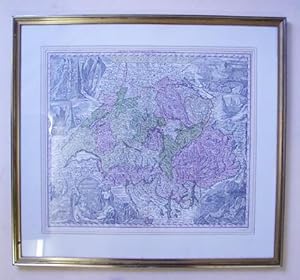
Nova Totius Helvetiae cum suis subditis. Kupferstich grenzkoloriert.
Idioma: Alemán
Publicado por Augsburg, Seutter, ca, 1730
Librería: antiquariat peter petrej - Bibliopolium AG, Zürich, ZH, Suiza
Miembro de asociación: ILAB VEBUKU
Calificación del vendedor: 5 de 5 estrellas
EUR 786,90
Envío por EUR 72,50
Se envía de Suiza a Estados Unidos de AmericaCantidad disponible: 1 disponibles
Ańadir al carrito71 x 77 cm, unter Passepartout blattvergoldet., 51 x 59 cm, Tadell. Unten links große Kartusche mit allegorischen Figuren des Rheins und anderer Flüsse, Wappen der Kantone. Ausserhalb der Grenze sind typische schweizer Landschaften abgebildet. Die Koloratur in dezentem Rosa, Grün, Türkis, Orange und Gelb. 1100 gr. Schlagworte: Helvetica - Allgemein, Reisen - Karten, Panoramen.
-
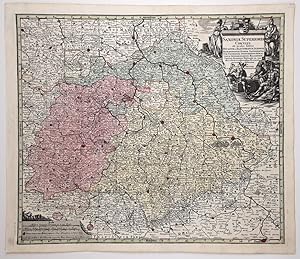
SAXONIA Superioris Circulus: Ducatum et Electoratum Saxonia - (kol. Kupferstich / ca. 1740)
Librería: BuchKunst-Usedom / Kunsthalle, Seebad Ahlbeck, Alemania
Calificación del vendedor: 2 de 5 estrellas
EUR 160,00
Envío por EUR 24,95
Se envía de Alemania a Estados Unidos de AmericaCantidad disponible: 1 disponibles
Ańadir al carritoKolorierte Kupferstichkarte von Ducatum et Electoratum Saxonia, Marchionatum Misnae, Landgraviatum Thurungiae, Principatum Anhaltinum, Schwarzenburg, Hallensem, Comitat Mansfeld, Voitland . ; Kupferstich von Matth. Seutter, Augsburg, ca. 1740; figürliche Titelkartusche oben rechts, Massstabskartusche unten links; Blatt: 53,5 x 62,5 cm, Abbildung: 50,5 x 58 cm; gut erhaltenes Blatt, im Randbereich gering fleckig. Gewicht in Gramm: 1200.
-

Sehr schöne, original altkolorierte Kupferstich-Landkarte, 1727. "Accurata Designatio celebris Freti prope ANDALUSIAE CASTELLUM GIBRALTAR," von Matthaeus Seutter (1678-1757) - Andalusien, Andalucía, Spanien, Espana, Spain
Ańo de publicación: 1727
Librería: Kunsthandlung Boschi, Innsbruck, Austria
Calificación del vendedor: 4 de 5 estrellas
Arte / Grabado / Póster
EUR 790,00
Envío por EUR 30,00
Se envía de Austria a Estados Unidos de AmericaCantidad disponible: 1 disponibles
Ańadir al carritoKein Einband. Condición: Sehr gut. Seutter, Matthaeus/ Seuttero Matth. / Seutteri Matthaei 1678 - 1757 Ilustrador. Original, altkolorierte Kupferstich Landkarte von Matthaei Seutteri, 1727. Andalusien (Andaluciŕ) Spanien/Espana/Spain, Gibraltar. Originally coloured, antique map - copper engraving. Sehr schöne Landkarte von Südspanien, zwischen Sanlůcar de Barrameda, Gibraltar und Motril, unterhalb befinden sich fünf Inselkarten: mit Malaga, Gibraltar, Cadix, Ceuta mit Umgebung in Afrika und eine Karte der Baleareninsel Menorca (Minorca). This beautiful map shows the south of Spain, embracing the area between Motril in the province of Granada in the east, Gibraltar in the south and Cadiz and Sanlůcar de Barrameda in the west. In this map you find Menorca, Ceuta, views of Malaga, Gibraltar and Cadiz. The map shows the area after the War of the Spanish Succession (1701 - 1714) when Gibraltar was given to Britain in 1713. Die Karte ist in einem sehr guten Zustand, breiter Rand, Mittelfalte, center fold, very good condition. Kartengröße: 58cm x 50cm, Blattgröße: 63cm x 53,5cm. Druckgrafik.
-
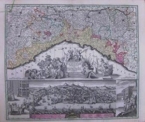
Reipublicae Genuensis Dominium.
Ańo de publicación: 1740
Librería: BOTTEGHINA D'ARTE GALLERIA KÚPROS, Rosignano Solvay, LI, Italia
Calificación del vendedor: 2 de 5 estrellas
Arte / Grabado / Póster
EUR 1.100,00
Envío por EUR 32,00
Se envía de Italia a Estados Unidos de AmericaCantidad disponible: 1 disponibles
Ańadir al carritoNo legatura. Condición: Buono. Augusta, 1740 circa. Incisione in rame, colore d'epoca, cm 50 x 58 (alla lastra). Se le carte del Seutter in molto assomigliano a quelle dell'Homann, tanto da non essere talvolta subito distinguibili, ciň che maggiormente le differenzia riguarda il cartiglio, spesso enormemente accresciuto con figure che si rifanno al mito, piuttosto che a qualche potente cui sia dedicata la stampa. Inoltre, non di rado, nella parte inferiore dl foglio, trovano spazio degli scorci di cittŕ, cosa che costituisce una su caratteristica peculiare rispetto ad altri editori, anche del passato. Esemplare con un'impressione un po' stanca e un leggero foxing al margine bianco, nell'insieme discreto stato.
-
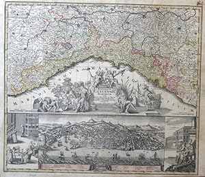
Republicae Genuensis Dominium.
Ańo de publicación: 1740
Librería: BOTTEGHINA D'ARTE GALLERIA KÚPROS, Rosignano Solvay, LI, Italia
Calificación del vendedor: 2 de 5 estrellas
Arte / Grabado / Póster
EUR 1.100,00
Envío por EUR 32,00
Se envía de Italia a Estados Unidos de AmericaCantidad disponible: 1 disponibles
Ańadir al carritoNo legatura. Condición: Buono. Augusta, 1740 circa. Incisione in rame, colore d'epoca, cm 50 x 58 (alla lastra), piů margini. Nella parte superiore carta geografica della Liguria, in quella inferiore una dettagliata veduta a volo d'uccello della cittŕ di Genova con ai lati due scene in riquadri; al centro un cartiglio con piccolo stemma e ricchissimo di figure allegoriche; in basso una veduta a volo d'uccello con 25 richiami per le cose notabili. Se le carte del Seutter molto assomigliano a quelle dell'Homann, tanto da non essere talvolta subito distinguibili, ciň che maggiormente le differenzia riguarda il cartiglio, spesso enormemente accresciuto, come in questo caso, dall'importanza delle figure legate al mito e all'allegoria. Un'impressione un po' tenue, margini con un leggero e normale ingiallimento, leggermente rifilato sulla destra il margine inferiore in corrispondenza della battuta della lastra, esemplare in bella coloritura e in buono stato di conservazione. .
