Importe total (1 artículo artículos):
Destino del pedido:

map turkey (48 resultados)
Ir a los resultados principales
Filtros de búsqueda
Tipo de artículo
- Todos los tipos de productos
- Libros (13)
- Revistas y publicaciones (No hay ningún otro resultado que coincida con este filtro.)
- Cómics (No hay ningún otro resultado que coincida con este filtro.)
- Partituras (No hay ningún otro resultado que coincida con este filtro.)
- Arte, grabados y pósters (No hay ningún otro resultado que coincida con este filtro.)
- Fotografías (No hay ningún otro resultado que coincida con este filtro.)
- Mapas (35)
- Manuscritos y coleccionismo de papel (No hay ningún otro resultado que coincida con este filtro.)
Condición Más información
- Nuevo (No hay ningún otro resultado que coincida con este filtro.)
- Como nuevo, Excelente o Muy bueno (1)
- Bueno o Aceptable (14)
- Regular o Pobre (No hay ningún otro resultado que coincida con este filtro.)
- Tal como se indica (33)
Encuadernación
Más atributos
- Primera edición (6)
- Firmado (No hay ningún otro resultado que coincida con este filtro.)
- Sobrecubierta (No hay ningún otro resultado que coincida con este filtro.)
- Con imágenes (35)
- No impresión bajo demanda (48)
Idioma (2)
Gastos de envío gratis
- Envío gratis a Estados Unidos de America (No hay ningún otro resultado que coincida con este filtro.)
Ubicación del vendedor
Valoración de los vendedores
-

TURKEY, AN ANTIQUE MAP, CIRCA 1880
Idioma: Inglés
Publicado por WILLIAM MACKENZIE, Edinburgh, 1880
Librería: K Books Ltd ABA ILAB, York, YORKS, Reino Unido
Miembro de asociación: ABA ILAB PBFA
Calificación del vendedor: 5 de 5 estrellas

Original o primera edición
EUR 15,38
Envío por EUR 22,57
Se envía de Reino Unido a Estados Unidos de AmericaCantidad disponible: 1 disponibles
Ańadir al carritoSingle Sheet Engraving. Condición: Very Good. No Jacket. First Edition. TURKEY, AN ANTIQUE MAP, CIRCA 1880, A VERY GOOD MAP . VERY REASONABLY PRICED, . MEASURES 11 X 9 INCHES, 28 X 23 CMS, INCHES, ELABORATE BORDER, CIRCA 1860. DISPATCH WELL PACKED AND ROLLED IN A STRONG TUBE, VERY GOOD CONDITION, SPLENDID VALUE.
-
TURKEY IN EUROPE AN ANTIQUE MAP CIRCA 1860
Idioma: Inglés
Publicado por LONDON PRINTING AND PUBLISHING COMPANY, London, 1860
Librería: K Books Ltd ABA ILAB, York, YORKS, Reino Unido
Miembro de asociación: ABA ILAB PBFA
Calificación del vendedor: 5 de 5 estrellas
Original o primera edición
EUR 15,38
Envío por EUR 22,57
Se envía de Reino Unido a Estados Unidos de AmericaCantidad disponible: 1 disponibles
Ańadir al carritoSingle Sheet Engraving. Condición: Very Good. No Jacket. First Edition. TURKEY IN EUROPE, AN ANTIQUE MAP CIRCA 1860, A VERY GOOD MAP . VERY REASONABLY PRICED, . MEASURES 13 X 10 INCHES, ELABORATE BORDER, CIRCA 1860. DISPATCH WELL PACKED ROLLED IN A STRONG TUBE, VERY GOOD CONDITION, SPLENDID VALUE.
-
Map of Turkey in Europe - an Original Engraving
Idioma: Inglés
Librería: K Books Ltd ABA ILAB, York, YORKS, Reino Unido
Miembro de asociación: ABA ILAB PBFA
Calificación del vendedor: 5 de 5 estrellas
EUR 23,85
Envío por EUR 22,57
Se envía de Reino Unido a Estados Unidos de AmericaCantidad disponible: 1 disponibles
Ańadir al carritoNo Binding. Condición: Very Good. A fine Engraving - printed circa 1870. Mounted and ready to frame. A fine opportunity to purchase an attractive and decorative engraved Map of Turkey in Europe.
-
Map of Turkey - an Original Engraving
Idioma: Inglés
Librería: K Books Ltd ABA ILAB, York, YORKS, Reino Unido
Miembro de asociación: ABA ILAB PBFA
Calificación del vendedor: 5 de 5 estrellas
EUR 23,85
Envío por EUR 22,57
Se envía de Reino Unido a Estados Unidos de AmericaCantidad disponible: 1 disponibles
Ańadir al carritoNo Binding. Condición: Very Good. A fine Engraving - printed circa 1870. Mounted and ready to frame. A fine opportunity to purchase an attractive and decorative engraved Map of Turkey.
-
TURKEY IN EUROPE - An Original Antique Hand Coloured Map
Idioma: Inglés
Publicado por LONDON PRINTING, London, 1857
Librería: K Books Ltd ABA ILAB, York, YORKS, Reino Unido
Miembro de asociación: ABA ILAB PBFA
Calificación del vendedor: 5 de 5 estrellas
EUR 41,73
Envío por EUR 22,57
Se envía de Reino Unido a Estados Unidos de AmericaCantidad disponible: 1 disponibles
Ańadir al carritoNo Binding. Condición: Very Good. Rapkin Ilustrador. A fine original antique hand coloured map, colouring not contemporary but delicately and expertly executed . . Mounted (matted) and ready to frame. Central fold otherwise very good condition. A splendid opportunity to acquire an antique original map - decorative, attractive and scarce . A splendid map of Turkey in Europe, with vignettes of Constantinople, Bosphorus, Ali Pasha etc with an inset map of Candia.
-
Map of Turkey & Hungary - an Original Antique Engraving
Idioma: Inglés
Ańo de publicación: 1820
Librería: K Books Ltd ABA ILAB, York, YORKS, Reino Unido
Miembro de asociación: ABA ILAB PBFA
Calificación del vendedor: 5 de 5 estrellas
EUR 35,77
Envío por EUR 22,57
Se envía de Reino Unido a Estados Unidos de AmericaCantidad disponible: 1 disponibles
Ańadir al carritoNo Binding. Condición: Slight Crease. An original hand-coloured antique engraved map, printed circa 1820. Hand-colouring contemporary. Mounted/matted and ready to frame. A fine opportunity to purchase an attractive and decorative engraving of a Map of Turkey & Hungary - Asia.
-

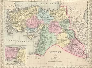
Turkey in Asia, with Russian Armenia and the Countries on the Caucasus.
Idioma: Inglés
Publicado por London & Liverpool: George Philip & Son, n.d. c. ?1880., 1880
Librería: Meridian Rare Books ABA PBFA, London, Reino Unido
Miembro de asociación: ABA ILAB PBFA
Calificación del vendedor: 5 de 5 estrellas
Mapa Original o primera edición
EUR 178,85
Envío por EUR 28,94
Se envía de Reino Unido a Estados Unidos de AmericaCantidad disponible: 1 disponibles
Ańadir al carritoHardcover. Condición: Very Good. 1st Edition. A coloured lithograph map, approx. 26 x 21" (65 x 53cm.), laid down on linen and folding into original covers lettered in black and gilt, 24pp. Index of Names pasted inside upper board, in very good condition. Issued in 'Philips' Companion Maps for Tourists and Travellers' series, this map shows the Ottoman Empire from the coasts of Asia Minor and the Black Sea to the western shores of the Caspian Sea, the northwest coast of the Persian Gulf and the Nile delta.
-

The Ottoman Empire The Black Sea and the Frontiers of Russia and Persia.
Idioma: Inglés
Publicado por London: James Wyld, n.d. c. 1853., 1853
Librería: Meridian Rare Books ABA PBFA, London, Reino Unido
Miembro de asociación: ABA ILAB PBFA
Calificación del vendedor: 5 de 5 estrellas
Mapa Original o primera edición
EUR 208,66
Envío por EUR 28,94
Se envía de Reino Unido a Estados Unidos de AmericaCantidad disponible: 1 disponibles
Ańadir al carritoSoft cover. Condición: Very Good. 1st Edition. An engraved map, coloured in outline, approx. 25 x 18" (64 x 46cm.), inset maps of Odessa, Sevastopol, Batoum, Dardanelles and Bosphorus, sectionalised on linen, folding into original covers with the publisher's label (not captioned), slight age-toning to map, browning to verso of one panel, else in very good condition, covers rubbed. Wyld's map shows the borders between Russia and Turkey around the time of the Crimean War. Dates at key points indicate Russian acquisitions from the 1770s to the 1830s.
-
Turkey with Provinces in Asia Minor - an Antique Map
Idioma: Inglés
Librería: K Books Ltd ABA ILAB, York, YORKS, Reino Unido
Miembro de asociación: ABA ILAB PBFA
Calificación del vendedor: 5 de 5 estrellas
EUR 41,73
Envío por EUR 22,57
Se envía de Reino Unido a Estados Unidos de AmericaCantidad disponible: 1 disponibles
Ańadir al carritoNo Binding. Condición: Very Good. Engraved By Walker Ilustrador. A fine antique map in very good condition - printed in circa 1844. Mounted (matted) and ready to frame. Engraved size approx 16 x 13 Ins, 41 x 33 Cms. Mounted size approx 19 x 16 in, 49 x 41cm. Coloured in outline, hand colouring contemporary. A fine engraved map of Turkey with Provinces in Asia Minor.
-
Turkey and Northern Provinces - an Antique Map
Idioma: Inglés
Librería: K Books Ltd ABA ILAB, York, YORKS, Reino Unido
Miembro de asociación: ABA ILAB PBFA
Calificación del vendedor: 5 de 5 estrellas
EUR 41,73
Envío por EUR 22,57
Se envía de Reino Unido a Estados Unidos de AmericaCantidad disponible: 1 disponibles
Ańadir al carritoNo Binding. Condición: Very Good. Engraved By Walker Ilustrador. A fine antique map in very good condition - printed in circa 1844. Mounted (matted) and ready to frame. Engraved size approx 16 x 13 Ins, 41 x 33 Cms. Mounted size approx 19 x 16 in, 49 x 41cm. Coloured in outline, hand colouring contemporary. A fine engraved map of Turkey and Northern Provinces.
-
Turkey, with North Part of Greece - an Antique Map
Idioma: Inglés
Librería: K Books Ltd ABA ILAB, York, YORKS, Reino Unido
Miembro de asociación: ABA ILAB PBFA
Calificación del vendedor: 5 de 5 estrellas
EUR 41,73
Envío por EUR 22,57
Se envía de Reino Unido a Estados Unidos de AmericaCantidad disponible: 1 disponibles
Ańadir al carritoNo Binding. Condición: Very Good. Engraved By Walker Ilustrador. A fine antique map in very good condition - printed in circa 1844. Mounted (matted) and ready to frame. Engraved Size 14 x 10 Ins 35 x 25 cms. Mount size approx 17 x 13 ins, 43 x33 cms. Coloured in outline, hand colouring contemporary. A fine engraved map of Turkey, with North Part of Greece.
-
Map of Turkey - the Retreat of the Ten Thousand - Fine Detailed Map - an Original Engraving
Idioma: Inglés
Ańo de publicación: 1840
Librería: K Books Ltd ABA ILAB, York, YORKS, Reino Unido
Miembro de asociación: ABA ILAB PBFA
Calificación del vendedor: 5 de 5 estrellas
EUR 47,69
Envío por EUR 22,57
Se envía de Reino Unido a Estados Unidos de AmericaCantidad disponible: 1 disponibles
Ańadir al carritoNo Binding. Condición: Very Good. A fine engraving - printed circa 1840. Mounted and ready to frame. Hand colouring not contemporary, but delicately and expertly executed. A fine opportunity to purchase an attractive and decorative engraving - Map of Turkey - the Retreat of the Ten Thousand.
-
Turkey Map Antique Map
Idioma: Inglés
Ańo de publicación: 1790
Librería: K Books Ltd ABA ILAB, York, YORKS, Reino Unido
Miembro de asociación: ABA ILAB PBFA
Calificación del vendedor: 5 de 5 estrellas
EUR 47,69
Envío por EUR 22,57
Se envía de Reino Unido a Estados Unidos de AmericaCantidad disponible: 1 disponibles
Ańadir al carritoNo Binding. Condición: Very Good. Antique map . Hand coloured, engraved map. mounted - matted - and ready to frame .12 x 10 inches. a vg copy of an attractive decorative hand coloured antique map. . A splendid map, colouring not contemporary but delicately and expertly done - a fine map of Turkey.
-
Turkey, with Southern Part of Greece and Candia - with Vignette of Athens - an Antique Map
Idioma: Inglés
Librería: K Books Ltd ABA ILAB, York, YORKS, Reino Unido
Miembro de asociación: ABA ILAB PBFA
Calificación del vendedor: 5 de 5 estrellas
EUR 53,66
Envío por EUR 22,57
Se envía de Reino Unido a Estados Unidos de AmericaCantidad disponible: 1 disponibles
Ańadir al carritoNo Binding. Condición: Very Good. Engraved By Walker Ilustrador. A fine antique map in very good condition - printed in circa 1844. Mounted (matted) and ready to frame. Engraved size approx 16 x 13 Ins, 41 x 33 Cms. Mounted size approx 19 x 16 in, 49 x 41cm. Coloured in outline, hand colouring contemporary. A fine engraved map of Turkey, with Southern Part of Greece and Candia - with Vignette of Athens.
-
Handmade map of Adana / Mersin [Cilicia].
Idioma: Inglés
Publicado por c. 1900., 1900
Librería: BOSPHORUS BOOKS, Istanbul, Turquia
Calificación del vendedor: 4 de 5 estrellas

Mapa
EUR 1.500,00
Envío por EUR 35,00
Se envía de Turquia a Estados Unidos de AmericaCantidad disponible: 1 disponibles
Ańadir al carritoNo Binding. Condición: As New. MAP - CILICIA / TURKEY Handmade map of Adana / Mersin [Cilicia]. c. 1900. In French. 91x129 cm. As new ISBN: CATALOG: Maps & Engravings KEYWORDS: Map Geography Cilicia Adana Mersin Alexandretta.
-
Map of Turkey in Europe Illustrating the Berlin Congress Treaty, July, 1878
Publicado por Mitchell's, Philadelphia, 1879
Librería: Main Street Fine Books & Mss, ABAA, Galena, IL, Estados Unidos de America
Miembro de asociación: ABAA ILAB MWABA
Calificación del vendedor: 5 de 5 estrellas
Mapa
EUR 66,47
Envío por EUR 5,16
Se envía dentro de Estados Unidos de AmericaCantidad disponible: 1 disponibles
Ańadir al carrito15" X 23Ľ" (image 14Ľ" X 20˝"). Printed coloring. Near fine. Single center fold (as issued). Attractive example of this large map bearing printed border coloring. Small inset at lower left features "A Map Showing the Relation of Cyprus to the Adjacent Coasts" and larger inset at lower left features "Map of Armenia to illustrate Articles 58, 59, 60 of the Treaty of Berlin." Quite interesting and in lovely condition.
-

Map of Turkey in Europe Together with the Ionian Islands
Publicado por Charles Desilver, Philadelphia, 1856
Librería: Main Street Fine Books & Mss, ABAA, Galena, IL, Estados Unidos de America
Miembro de asociación: ABAA ILAB MWABA
Calificación del vendedor: 5 de 5 estrellas
Mapa
EUR 84,20
Envío por EUR 5,16
Se envía dentro de Estados Unidos de AmericaCantidad disponible: 1 disponibles
Ańadir al carrito13 3/4" X 17Ľ" (image 9 3/4" X 12"). Hand colored. Near fine. Exceptionally clean and large-margined example of this lovely map. Lovely decorative border.
-
Turkey in Asia
Publicado por Charles Desilver, Philadelphia, 1856
Librería: Main Street Fine Books & Mss, ABAA, Galena, IL, Estados Unidos de America
Miembro de asociación: ABAA ILAB MWABA
Calificación del vendedor: 5 de 5 estrellas
Mapa
EUR 88,63
Envío por EUR 5,16
Se envía dentro de Estados Unidos de AmericaCantidad disponible: 1 disponibles
Ańadir al carrito17Ľ" X 13 3/4" (image 15" X 12Ľ"). Hand colored. Near fine. This bright, handsome example features a sharp inset at lower left showing "Environs of Constantinople" and nifty decorative border. Large, clean margins.
-
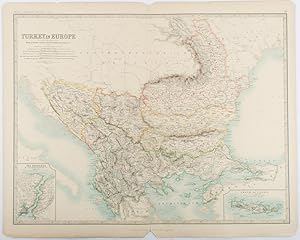
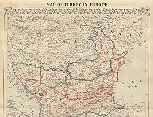
Turkey in Europe.with Rumania, Servia, Montenegro, Bulgaria &c.
Publicado por W. & A. K. Johnston, Edinburgh & London., 1893
Librería: Asia Bookroom ANZAAB/ILAB, Canberra, ACT, Australia
Miembro de asociación: ANZAAB ILAB
Calificación del vendedor: 5 de 5 estrellas
EUR 79,47
Envío por EUR 25,81
Se envía de Australia a Estados Unidos de AmericaCantidad disponible: 1 disponibles
Ańadir al carritoEngraved map with original outline hand-colour, 44 x 57.4 cm (map), two inset maps of the Bosphorus and Crete; central fold, corners chipped with loss, lower edge with several small marginal tears, neatly repaired, head and foot clipped at the fold with loss to the margin, but the map in very good condition. Detailed and finely engraved map also showing submarine telegraph lines and relief by hachures. Re-issue of the map first published in 1863 for "Keith Johnston's Royal Atlas of Modern Geography".
-

Turquie Europe.
Ańo de publicación: 1843
Librería: Geographicus Rare Antique Maps, Brooklyn, NY, Estados Unidos de America
Miembro de asociación: ABAA ESA ILAB
Calificación del vendedor: 4 de 5 estrellas
Mapa
EUR 99,26
Envío por EUR 14,63
Se envía dentro de Estados Unidos de AmericaCantidad disponible: 1 disponibles
Ańadir al carritoVery good. Blank on verso. Size 13 x 9.5 Inches. This is a fine example of Conrad Malte-Brun's 1843 map of Greece, the Balkans, and the european Part of Turkey. It covers from Moldova to Crete and from the Adriatic to the Black Sea. The modern day states of Greece, Albania, Moldova, Bosnia, Croatia, Serbia, Bulgaria and Romania are included. This map depicts the waning years of Ottoman hegemony in the region. The Greek Independence movement attained sovereignty for the Peloponnese in 1821. The other Grecian and Balkan states, including Serbia, Croatia, Moldavia, Wallachia, Albania, and Macedonia, remained at least nominally under Ottoman control until 1878. Various cities, towns, rivers, islands and other topographical details are marked, with relief shown by hachure. Boundaries are color coded according to regions and territories. This map was issued as plate no. 57 in Conrad Malte-Brun's 1843 Precis de la Geographie Universelle .
-

Turkey in Europe.
Ańo de publicación: 1855
Librería: Geographicus Rare Antique Maps, Brooklyn, NY, Estados Unidos de America
Miembro de asociación: ABAA ESA ILAB
Calificación del vendedor: 4 de 5 estrellas
Mapa Original o primera edición
EUR 99,26
Envío por EUR 14,63
Se envía dentro de Estados Unidos de AmericaCantidad disponible: 1 disponibles
Ańadir al carrito1st Edition. Very good condition. Blank on verso. Size 13.5 x 16 Inches. An excellent 1855 first edition example of Colton's map of European Turkey. Like most of Colton's Europe maps, this map was derived from an earlier wall map of the world produced by Colton and D. Griffing Johnson. This map, made when the Ottoman empire controlled much of the region, covers what are today parts of Greece, Turkey, Macedonia, Albania, Bosnia, Serbia, Croatia, Bulgaria, Montenegro, and Moldova. An inset map in the lower left quadrant details the Bosporus and Istanbul (Constantinople). Another inset map, in the lower right, focuses on the island of Candia or Crete. This map depicts the waning years of Ottoman hegemony in the region, with the Greek Independence movement achieving Peloponnesian sovereignty in 1821. The Ionian Republic, under the protection of Great Britain, was also free of Ottoman control. The other Grecian and Balkan states, including Serbia, Croatia, Moldavia, Wallachia, Albania, and Macedonia, remained at least nominally under Ottoman control until 1878. This map also identifies various cities, towns, rivers, rapids, mountain passes, and an assortment of additional topographical details. Map is hand colored in pink, green, yellow and blue pastels to define national and regional boundaries. Surrounded by Colton's typical spiral motif border. Dated and copyrighted to J. H. Colton, 1855. Published from Colton's 172 William Street Office in New York City. Issued as page no. 22 in volume 2 of Colton's 1856 Atlas of the World. References: Rumsey 0149.089 (1856 edition). Phillips (Atlases) 816.
-

Turquie d'Europe.
Ańo de publicación: 1853
Librería: Geographicus Rare Antique Maps, Brooklyn, NY, Estados Unidos de America
Miembro de asociación: ABAA ESA ILAB
Calificación del vendedor: 4 de 5 estrellas
Mapa
EUR 99,26
Envío por EUR 14,63
Se envía dentro de Estados Unidos de AmericaCantidad disponible: 1 disponibles
Ańadir al carritoVery good. Blank on verso. Map exhibits some soiling and toning, especially to margins. Size 13 x 10 Inches. An uncommon and extremely attractive 1852 map of Turkey in europe and Greece by A. Vuillemin. Centered on the Aegean Sea, this map covers from Moldova to Crete and from the Adriatic to the Black Sea. Also shows part of the Austrian empire (Hungary), Turkey in Asia and Italy. Throughout, the map identifies various cities, towns, rivers and assortment of additional topographical details. This map, made when the Ottoman empire controlled much of the region, covers what is today Turkey, Greece, Bosnia, Serbia, Romania, Bulgaria, Macedonia and Albania. This map depicts the waning years of Ottoman hegemony in the region, with the Greek nationalist movement attaining independence for the Peloponnese in 1821. The Ionian Republic, under the protection of Great Britain, was also free of Ottoman control. The other Grecian and Balkan states, including Serbia, Croatia, Moldavia, Wallachia, Albania, and Macedonia, remained at least nominally under Ottoman control until 1878. The map features a beautiful frame style border. Prepared by A. Vuillemin for publication as plate no. 18 in the 1852 Maison Basset edition of Atlas Illustre Destine a l'enseignement de la Geographie elementaire .
-

Northern Turkey in Europe with parts of Hungary and Dalmatia.
Ańo de publicación: 1828
Librería: Geographicus Rare Antique Maps, Brooklyn, NY, Estados Unidos de America
Miembro de asociación: ABAA ESA ILAB
Calificación del vendedor: 4 de 5 estrellas
Mapa
EUR 99,26
Envío por EUR 14,63
Se envía dentro de Estados Unidos de AmericaCantidad disponible: 1 disponibles
Ańadir al carritoVery good. Original platemark visible. Blank on verso. Notable reapir work to damage on title and bottom right corner of map. Size 11 x 13 Inches. This is a rare example of Aaron Arrowsmith's 1828 map of Turkey in Europe. The map covers Turkey or the Ottoman Empire as it extended into Europe during the early 19th century and includes the Balkan regions of Bosnia, Herzegovina, Monde Negro, Albania, Thessaly, Macedonia, Rumilia, Bulgaria, Walachia and Serbia. It also shows parts of Hungary, Transylvania and Dalmatia. The regional political boundaries are colored and relief shown by hachures. This map was published by A. Arrowsmith, hydrographer to His Majesty, in 1828.
-

Turkey in Asia.
Ańo de publicación: 1851
Librería: Geographicus Rare Antique Maps, Brooklyn, NY, Estados Unidos de America
Miembro de asociación: ABAA ESA ILAB
Calificación del vendedor: 4 de 5 estrellas
Mapa
EUR 124,08
Envío por EUR 14,63
Se envía dentro de Estados Unidos de AmericaCantidad disponible: 1 disponibles
Ańadir al carritoVery good. Minor overall toning. Blank on verso. Size 11 x 16 Inches. This is a fine example of the Adam and Charles Black's 1851 map of Turkey in Asia. Centered on the Holy land (Palestine / Israel), the map covers the modern day countries of Turkey, Cyprus, Iraq, Israel, Palestine, Jordan, Lebanon, and Syria. An inset near the bottom margin details the Ruins of Babylon. A. and C. Black issued this map in the last days of the Ottoman empire, whose hegemony, though rapidly declining, still influenced much of the Middle east. Various cities, towns, rivers, mountains and several other topographical details are noted with relief shown in hachures. This map was engraved by George Aikman and issued as plate no. XXXVI in the 1851 edition of Black's General Atlas of the World . References: Rumsey 2305.041 (1854 edition). Philips (atlases) 4334.
-

Turquie d'Asie et les Provinces du Caucase.
Ańo de publicación: 1878
Librería: Geographicus Rare Antique Maps, Brooklyn, NY, Estados Unidos de America
Miembro de asociación: ABAA ESA ILAB
Calificación del vendedor: 4 de 5 estrellas
Mapa
EUR 124,08
Envío por EUR 14,63
Se envía dentro de Estados Unidos de AmericaCantidad disponible: 1 disponibles
Ańadir al carritoVery good. Original centerfold. Blank on verso. Size 12.5 x 16 Inches. This is a fine example of J. Migeon's 1878 map of Turkey in Asia and the Caucuses. Migeon's map covers from the Crimea south to egypt, west as far as the Aegean, and east to the Caspian Sea and the Persian Gulf. The map essentially covers the mid-19th century claims of the Ottoman empire, including the modern nations of Turkey, Iraq, Kuwait, Syria, Jordan, Israel or Palestine, Armenia, Georgia, and Azerbaijan, with parts of adjacent Iran, Greece, egypt and Ukraine. The lower left quadrant includes a beautiful illustration of Smyrne (the ancient city of Smyrna). The map dates to the last days of the Ottoman empire, whose influence, though rapidly declining, dominated much of the Middle east. Various rivers, islands, mountain passes and other topographical features are identified. Migeon's Geographie Universelle , published in Paris, is one of the last great decorative atlases of the 19th century. It contains many stylistic elements of early 19th century cartography such as full hand coloring, numerous decorative vignettes, and high quality paper. This map was issued as plate no. 28 in Migeon's Geographie Universelle .
-

Turkey in Asia.
Ańo de publicación: 1849
Librería: Geographicus Rare Antique Maps, Brooklyn, NY, Estados Unidos de America
Miembro de asociación: ABAA ESA ILAB
Calificación del vendedor: 4 de 5 estrellas
Mapa
EUR 148,89
Envío por EUR 14,63
Se envía dentro de Estados Unidos de AmericaCantidad disponible: 1 disponibles
Ańadir al carritoVery good. Minor foxing and overall toning. Minor edge wear. Size 13 x 15.5 Inches. A fine example of S. A. Mitchell's 1849 map of Turkey in Asia. Centered on the Holy Land, this map covers the Asian territories claimed by the Turkish Ottoman Empire. These include the modern day countries of Turkey, Cyprus, Syria, Jordan, Lebanon, and Iraq. An inset in the lower left quadrant details the environs of Constantinople and the Bosporus Straits. The important caravan route from to Rosrah, on the Persian Gulf, is noted. Political and topographical features are noted and color coded with elevation rendered by hachure. The whole is engraved and colored in Mitchell's distinctive style with green border work and vivid pastels. Mitchell published this chart in his atlas from 1846 to the late 1850s before discontinuing the series and selling his map plates to DeSilver. This map was issued in the 1849 edition of the New Universal Atlas . It was the last edition of that atlas to be published by Mitchell prior to selling the plates and rights to the atlas to Thomas Cowperthwait in 1850. References: Rumsey 0545.069.
-

Turkey in Asia.
Ańo de publicación: 1845
Librería: Geographicus Rare Antique Maps, Brooklyn, NY, Estados Unidos de America
Miembro de asociación: ABAA ESA ILAB
Calificación del vendedor: 4 de 5 estrellas
Mapa
EUR 148,89
Envío por EUR 14,63
Se envía dentro de Estados Unidos de AmericaCantidad disponible: 1 disponibles
Ańadir al carritoVery good. Minor foxing at places. Blank on verso. Size 8 x 9.5 Inches. This is a fine example of the 1845 Thomas Ewing map of Turkey in Asia. It covers from the Black Sea to Egypt, inclusive Cyprus. Centered on the Holy land (Palestine / Israel), the map covers the modern day countries of Turkey, Cyprus, Iraq, Israel, Palestine, Jordan, Lebanon, and Syria. Divided and color coded according to regions and territories, the map identifies various cities, towns, islands, rivers, and an assortment of additional topographical details. It dates to the last days of the Ottoman Empire, whose influence, though rapidly declining, still dominated much of the Middle East. This map was published in 1845 by Oliver and Boyd as part of Ewing's New General Atlas .
-

Turkey in Asia.
Ańo de publicación: 1850
Librería: Geographicus Rare Antique Maps, Brooklyn, NY, Estados Unidos de America
Miembro de asociación: ABAA ESA ILAB
Calificación del vendedor: 4 de 5 estrellas
Mapa
EUR 148,89
Envío por EUR 14,63
Se envía dentro de Estados Unidos de AmericaCantidad disponible: 1 disponibles
Ańadir al carritoVery good condition. Size 12.5 x 15 Inches. This beautiful hand colored map is a lithographic engraving of Turkey in Asia, dating to 1850. Beautiful map depicts most of modern day nations of Turkey, Iran, Iraq, Israel, Palestine, Jordan, Syria, Lebanon and Kuwait. There is a beautiful inset of the Environs of Constantinople or Istanbul. Produced by the legendary American map publisher S. A. Mitchell Sr. in conjunction with the Cowperthwait firm of Philadelphia, PA. Dated and copyrighted '1850 by Thomas Cowperthwait & Co in the Clerk's Office of the District court of the Eastern District of Pennsylvania.
-

Asie Ottomane ou Turquie d'Asie.
Ańo de publicación: 1852
Librería: Geographicus Rare Antique Maps, Brooklyn, NY, Estados Unidos de America
Miembro de asociación: ABAA ESA ILAB
Calificación del vendedor: 4 de 5 estrellas
Mapa
EUR 148,89
Envío por EUR 14,63
Se envía dentro de Estados Unidos de AmericaCantidad disponible: 1 disponibles
Ańadir al carritoVery good. Blank on verso. Minor foxing throughout. Size 10 x 13 Inches. An uncommon and extremely attractive 1852 map of Turkey in Asia by Victor Levasseur. The map covers the Asian territories claimed by the Turkish Ottoman empire c. 1850 from the Black Sea to Arabia, including Cyprus. Centered on the Holy land (Palestine / Israel), the map covers the modern day countries of Turkey, Cyprus, Iraq, Israel, Palestine, Jordan, Lebanon, and Syria. Throughout, the map identifies various cities, towns, rivers and assortment of additional topographical details. The map to the last days of the Ottoman empire, whose influence, though rapidly declining, still dominated much of the Middle east. The map features a beautiful frame style border. Prepared by Victor Levasseur for publication as plate no. 21 in Maison Basset's 1852 edition of Atlas Illustre Destine a l'enseignement de la Geographie elementaire .
-

1844 Constantinople. Stambool
Librería: New World Cartographic, Chicago, IL, Estados Unidos de America
Miembro de asociación: ABAA ILAB
Calificación del vendedor: 4 de 5 estrellas
Mapa
EUR 177,25
Envío por EUR 2,58
Se envía dentro de Estados Unidos de AmericaCantidad disponible: 1 disponibles
Ańadir al carritoBy: SDUKDate: 1844 (circa) LondonDimensions: 12.5 x 15.2 inches (31.8 x 38.6 cm)This lovely map of Constantinople, today's Istanbul, was published in 1844 by the Society for the Diffusion of Useful Knowledge also referred to as SDUK.The map shows the only city of the world to occupy territory on two continents, Europe and Asia, and it has long been called the meeting place of the east and west. The great waterway called the Bosphorus divides the two continents, flowing through what once were heavily wooded hills, joining the Black Sea with the Sea of Marmara. A natural moat known as the Golden Horn historically provided extra protection for large areas of the city along its shores.Due to its strategic location Istanbul is an ancient city, dating back countless millennia. Early Greek settlers founded a city which was known as Byzas (later called Byzantium), but more ancient peoples had settled the area long before the colony appeared. Due to its strategic location, the city has been of great importance to a number of empires, including the Eastern Roman Empire under Constantine the Great in 334 CE, who renamed it Constantinople (city of Constantine). From his founding of it as the capital of the Eastern Empire till 1453 when it was captured by the Ottoman Turks under Fatih Mehmet, it was one of the richest and most highly sophisticated cities in the world.The Ottomans had long tried to take the city, and when Mehmet the Conqueror finally succeeded, he tried to prevent his troops from destroying any of its countless architectural edifices. He had been impressed by the city's beauty, enamored from childhood.This map depicts the city as it appeared in the mid-19th century. The Ottoman Empire had been losing ground and strength, and the map concentrates primarily on extant historical sites, including some from Byzantium, and others of the Ottoman grand era, many of which had been converted from their prior Byzantine purposes. It also depicts Ottoman government buildings and ports.The SDUK was founded in 1828 by Henry Peter Brougham, an idealistic British nobleman. The aim of the society was to promote self-education and egalitarian sharing of knowledge by providing instruments of learning such as maps and various other publications. Despite being affiliated with London University and various major publishing houses, the Society ultimately failed to achieve its goal as the publications were too costly for the targeted middle to lower class echelons of British society. At the same time, its publications were not grand enough or fine enough to appeal to the aristocracy.Condition: This map is in A conditionwith outline hand coloring on clean paper with some light toning along the outer margins.Inventory #121971200 W. 35th Street #425 Chicago, IL 60609 | P: (312) 496 - 3622.