
Importe total (1 artículo artículos):
Destino del pedido:

map switzerland (59 resultados)
Ir a los resultados principales
Filtros de búsqueda
Tipo de artículo
- Todos los tipos de productos
- Libros (15)
- Revistas y publicaciones (No hay ningún otro resultado que coincida con este filtro.)
- Cómics (No hay ningún otro resultado que coincida con este filtro.)
- Partituras (No hay ningún otro resultado que coincida con este filtro.)
- Arte, grabados y pósters (No hay ningún otro resultado que coincida con este filtro.)
- Fotografías (No hay ningún otro resultado que coincida con este filtro.)
- Mapas (44)
- Manuscritos y coleccionismo de papel (No hay ningún otro resultado que coincida con este filtro.)
Condición Más información
- Nuevo (No hay ningún otro resultado que coincida con este filtro.)
- Como nuevo, Excelente o Muy bueno (2)
- Bueno o Aceptable (10)
- Regular o Pobre (No hay ningún otro resultado que coincida con este filtro.)
- Tal como se indica (47)
Encuadernación
Más atributos
- Primera edición (8)
- Firmado (No hay ningún otro resultado que coincida con este filtro.)
- Sobrecubierta (No hay ningún otro resultado que coincida con este filtro.)
- Con imágenes (45)
- No impresión bajo demanda (59)
Idioma (3)
Gastos de envío gratis
- Envío gratis a Estados Unidos de America (No hay ningún otro resultado que coincida con este filtro.)
Ubicación del vendedor
Valoración de los vendedores
-

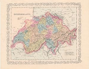
SWITZERLAND, AN ANTIQUE MAP CIRCA 1860
Idioma: Inglés
Publicado por LONDON PRINTING AND PUBLISHING COMPANY, London, 1860
Librería: K Books Ltd ABA ILAB, York, YORKS, Reino Unido
Miembro de asociación: ABA ILAB PBFA
Calificación del vendedor: 5 de 5 estrellas

Original o primera edición
EUR 15,32
Envío por EUR 22,48
Se envía de Reino Unido a Estados Unidos de AmericaCantidad disponible: 1 disponibles
Ańadir al carritoSingle Sheet Engraving. Condición: Very Good. No Jacket. First Edition. SWITZERLAND, AN ANTIQUE MAP CIRCA 1860. MEASURES 13 X 10 INCHES, ELABORATE BORDER, CIRCA 1860. DISPATCH WELL PACKED ROLLED IN A STRONG TUBE, VERY GOOD CONDITION, SPLENDID VALUE.
-
TOOGRAPHISCHER ATLAS DER SCHWEIZ - LUZERN [POCKET MAP]
Idioma: Alemán
Publicado por Schweixerische Landestopogaphie, Bern, 1917
Librería: Larry W Price Books, Portland, OR, Estados Unidos de America
Calificación del vendedor: 5 de 5 estrellas
EUR 26,48
Envío por EUR 4,31
Se envía dentro de Estados Unidos de AmericaCantidad disponible: 1 disponibles
Ańadir al carritoPamphlet. Condición: Very Good. Lge Color FoldOut Map (23 X 32 Inches), Folds to 5.25 7.5 Inches, Blue Illus Paper Covers, owner namestamps else VG (Scale 1:25,000).
-
Switzerland - Detailed Map Showing Roads, Towns , Explanation of the Signs Etc - an Original Antique Engraved Map
Idioma: Inglés
Publicado por George Virtue, 1836
Librería: K Books Ltd ABA ILAB, York, YORKS, Reino Unido
Miembro de asociación: ABA ILAB PBFA
Calificación del vendedor: 5 de 5 estrellas
EUR 29,69
Envío por EUR 22,48
Se envía de Reino Unido a Estados Unidos de AmericaCantidad disponible: 1 disponibles
Ańadir al carritoNo Binding. Condición: Very Good, Some Folds Showing. Engraved By Starling Ilustrador. An original antique engraved map, printed circa 1836. Hand-colouring not contemporary but delicately and expertly executed. Mounted and ready to frame. A fine opportunity to purchase an attractive and decorative map - Switzerland - Detailed Map Showing Roads, Towns , Explanation of the Signs.
-
Map, Antique of Switzerland - 19th Century
Idioma: Inglés
Ańo de publicación: 1880
Librería: K Books Ltd ABA ILAB, York, YORKS, Reino Unido
Miembro de asociación: ABA ILAB PBFA
Calificación del vendedor: 5 de 5 estrellas
EUR 17,81
Envío por EUR 22,48
Se envía de Reino Unido a Estados Unidos de AmericaCantidad disponible: 1 disponibles
Ańadir al carritoNo Binding. Condición: Very Good. An antique map, very good condition. Mounted - matted - and ready to frame. Mount size approx 12 x 10 inches, 36 x 30 cms. Original contemporary colouring. Circa 1880. Very detailed - Shows - Switzerland l - and coloured - attractive and reasonably priced - quite detailed.
-
Switzerland - Antiquarian Coloured Map
Idioma: Inglés
Publicado por H.G.Collins, London
Librería: K Books Ltd ABA ILAB, York, YORKS, Reino Unido
Miembro de asociación: ABA ILAB PBFA
Calificación del vendedor: 5 de 5 estrellas
EUR 35,63
Envío por EUR 22,48
Se envía de Reino Unido a Estados Unidos de AmericaCantidad disponible: 1 disponibles
Ańadir al carritoNo Binding. Condición: Very Good. An original antique map of Switzerland, ca. 1860. Mounted and ready to frame. Contemporary Colouring in outline. In excellent condition, decorative and impressive.
-
Map of Switzerland - an Original Engraving
Idioma: Inglés
Librería: K Books Ltd ABA ILAB, York, YORKS, Reino Unido
Miembro de asociación: ABA ILAB PBFA
Calificación del vendedor: 5 de 5 estrellas
EUR 23,75
Envío por EUR 22,48
Se envía de Reino Unido a Estados Unidos de AmericaCantidad disponible: 1 disponibles
Ańadir al carritoNo Binding. Condición: Very Good. A fine Engraving - printed circa 1870. Mounted and ready to frame. A fine opportunity to purchase an attractive and decorative engraved Map of Switzerland.
-
Music art Vol.14, No.15, 1954 Yukio Mishima Japanese Book
Publicado por Friend of music, china, 1980
Librería: Sunny Day Bookstore, SINGAPORE, Singapur
Calificación del vendedor: 4 de 5 estrellas

EUR 53,86
Envío por EUR 13,07
Se envía de Singapur a Estados Unidos de AmericaCantidad disponible: 1 disponibles
Ańadir al carritoCondición: Fine. KOS01200512.
-
GENERALKARTE DER SCHWEIZ BLATT I. NORDWESTLICHES VIERTEL
Ańo de publicación: 1871
Librería: Xerxes Fine and Rare Books and Documents, Glen Head, NY, Estados Unidos de America
Calificación del vendedor: 5 de 5 estrellas
EUR 40,39
Envío por EUR 5,19
Se envía dentro de Estados Unidos de AmericaCantidad disponible: 1 disponibles
Ańadir al carritoCondición: VG. 1871 Eidg. Topographisches Bureau. Map is 21 x 30 inches. In black and white. Each section of map is mounted on linen. Small owner name on front. VG.
-
MANOVERKARTE FUR DIE DIVISIONS UND BIRGADEUBUNGEN VI. - VILL. DIVISION IMP SEPTEMBER 1891
Ańo de publicación: 1891
Librería: Xerxes Fine and Rare Books and Documents, Glen Head, NY, Estados Unidos de America
Calificación del vendedor: 5 de 5 estrellas
EUR 40,39
Envío por EUR 5,19
Se envía dentro de Estados Unidos de AmericaCantidad disponible: 1 disponibles
Ańadir al carritoCondición: VG. 1891 Eidg. Topographisches Bureau. The main cities in this area of Switzerland are Frauenfeld and Winterthur. Map is 21 x 30 inches, in Color. Each section of map is mounted on linen. VG.
-
GENERALKARTE DER SCHWEIZ BLATT I. NORDWESTLICHES VIERTEL
Ańo de publicación: 1881
Librería: Xerxes Fine and Rare Books and Documents, Glen Head, NY, Estados Unidos de America
Calificación del vendedor: 5 de 5 estrellas
EUR 40,39
Envío por EUR 5,19
Se envía dentro de Estados Unidos de AmericaCantidad disponible: 1 disponibles
Ańadir al carritoCondición: VG. 1881 Eidg. Topographisches Bureau. Monochrome map, 21 x 30 inches. Each section of map is mounted on linen. Small owner name on front cover. VG.
-

Atlases, Travel and Topography Catalogue 244
Librería: Stoneman Press, York, YK, Reino Unido
Calificación del vendedor: 5 de 5 estrellas
EUR 41,29
Envío por EUR 32,29
Se envía de Reino Unido a Estados Unidos de AmericaCantidad disponible: 1 disponibles
Ańadir al carritoSoft cover. Condición: Fine. No Jacket. One full page colour illustration of 16th c. Ptolemaeus Atlas (first published map of Switzerland) Ilustrador. 518 Lots described in this impressive catalogue, including "our most important edition of Ptolomy and the most important Atlas of the 16th c. (1513)". See Index for geographical coverage in catalogue. Condition is Fine and catalogue is not annotated.
-
Switzerland Map Antique Map
Idioma: Inglés
Ańo de publicación: 1756
Librería: K Books Ltd ABA ILAB, York, YORKS, Reino Unido
Miembro de asociación: ABA ILAB PBFA
Calificación del vendedor: 5 de 5 estrellas
EUR 71,26
Envío por EUR 22,48
Se envía de Reino Unido a Estados Unidos de AmericaCantidad disponible: 1 disponibles
Ańadir al carritoNo Binding. Condición: Very Good. Antique map . Hand coloured, engraved map. mounted - matted - and ready to frame .12 x 10 inches. a vg copy of an attractive decorative hand coloured antique map. . A splendid map, colouring not contemporary but delicately and expertly done - a fine map of Switzerland - entitled 'Carte Des 13 Cantons Suisses - fine cartouche.
-
Switzerland
Publicado por Charles Desilver, Philadelphia, 1856
Librería: Main Street Fine Books & Mss, ABAA, Galena, IL, Estados Unidos de America
Miembro de asociación: ABAA ILAB MWABA
Calificación del vendedor: 5 de 5 estrellas
Mapa
EUR 89,76
Envío por EUR 5,23
Se envía dentro de Estados Unidos de AmericaCantidad disponible: 1 disponibles
Ańadir al carrito[14˝" X 12" (image 12" X 10"). Hand colored. Very good. Light foxing; minor mounting traces on verso. Lovely, beautifully multi-colored colored example with sharp ornamental border.
-
Topographischer Atlas der Schweiz 1: 50,000. Zweisimmer-Gemmi.
Publicado por Bern: Schweiz. Landestopographia, 1924
Librería: Michael Graves-Johnston, ABA, ILAB, London, Reino Unido
Miembro de asociación: ABA ILAB
Calificación del vendedor: 5 de 5 estrellas
EUR 111,64
Envío por EUR 32,29
Se envía de Reino Unido a Estados Unidos de AmericaCantidad disponible: 1 disponibles
Ańadir al carritoBern: Schweiz. Landestopographia, 1924 Coloured folding map, linen backed and discected into 18 sections. A very nice copy. We have been selling antiquarian books on Africa, Oceania, archaeology, anthropology, travel and the ancient world for over forty years. All our books are carefully catalogued and they are in excellent condition unless stated in the description. All shipments are fully insured at our expense. All books are carefully packaged in new packaging material and despatched by registered or recorded mail, or by a courier service; the customer is always able to track their shipment. All sales are accompanied by a VAT invoice. Photographs may be supplied if requested.[ ].
-
Blatt - Feuille XVII. Topographische Karte der Schweiz (Dufourkarte) Carte topographique de la Suisse (Carte Dufour) 1: 100000.
Publicado por Bern: Eidg. Landestopographie Service topographique fdral, 1923
Librería: Michael Graves-Johnston, ABA, ILAB, London, Reino Unido
Miembro de asociación: ABA ILAB
Calificación del vendedor: 5 de 5 estrellas
EUR 111,64
Envío por EUR 32,29
Se envía de Reino Unido a Estados Unidos de AmericaCantidad disponible: 1 disponibles
Ańadir al carritoUberdruck, 2 Farben. Bern: Eidg. Landestopographie, Service topographique federal, 1923 Folding map backed on linen discected into 18 segements. A very nice copy. We have been selling antiquarian books on Africa, Oceania, archaeology, anthropology, travel and the ancient world for over forty years. All our books are carefully catalogued and they are in excellent condition unless stated in the description. All shipments are fully insured at our expense. All books are carefully packaged in new packaging material and despatched by registered or recorded mail, or by a courier service; the customer is always able to track their shipment. All sales are accompanied by a VAT invoice. Photographs may be supplied if requested.[ ].
-
Chateau d'Oex-Col des Mosses. Echelle 1:25000.
Publicado por Berne: Edit pour le Ski-Club Alpina Chteau d'Oex par le Service topographique fdral, 1927
Librería: Michael Graves-Johnston, ABA, ILAB, London, Reino Unido
Miembro de asociación: ABA ILAB
Calificación del vendedor: 5 de 5 estrellas
EUR 148,46
Envío por EUR 32,29
Se envía de Reino Unido a Estados Unidos de AmericaCantidad disponible: 1 disponibles
Ańadir al carritoBerne: Edite pour le Ski-Club Alpina Chateau d'Oex par le Service topographique federal, 1927 Coloured folding map backed on linen discected into 24 segements. A very nice copy. We have been selling antiquarian books on Africa, Oceania, archaeology, anthropology, travel and the ancient world for over forty years. All our books are carefully catalogued and they are in excellent condition unless stated in the description. All shipments are fully insured at our expense. All books are carefully packaged in new packaging material and despatched by registered or recorded mail, or by a courier service; the customer is always able to track their shipment. All sales are accompanied by a VAT invoice. Photographs may be supplied if requested.[O].
-

Excursions Carte des Trois Lacs and Lac de Garde.
Ańo de publicación: 1937
Librería: Geographicus Rare Antique Maps, Brooklyn, NY, Estados Unidos de America
Miembro de asociación: ABAA ESA ILAB
Calificación del vendedor: 4 de 5 estrellas
Mapa
EUR 251,33
Envío por EUR 14,81
Se envía dentro de Estados Unidos de AmericaCantidad disponible: 1 disponibles
Ańadir al carritoSoft cover. Very good. Some wear along fold lines, mends at few junctures of folds. Size 12.25 x 18 Inches. A charming 1937 folding relief map of the Italian lake region, including Lake Maggiore, Lake Lugano, and Lake Como. It was produced by Arti Grafiche Testoni and Co., a commercial printer of such foldout maps and brochures catering to tourists, based in Milan and Como. A Closer Look This view is oriented towards the north with Milan in the foreground and the Alps in the background. The map reaches just as far north as the Swiss town of Bellinzona. The three glacial lakes referred to in the title command the eye visually, but the lower part of the map amply details the roadways connecting the Lake Region with the cities of Milan and Novara. In particular, the new Autostrade connecting Milan with Gallarate, Varese, Como, and Sesto Calende is printed in red. (These routes are now the A8 and A). Aside from lakes and rivers, cities, towns, major roads, minor roads, and mountains with their heights in meters are illustrated. The front cover panel is decorated with three views taken from the lakes featured in the title. The back cover, meanwhile, displays a map of the Lago de Garda. It is notable that the title of the brochure is in French, implying that it was intended for French-speaking tourists from other parts of Switzerland or France. Publication History and Census This map was printed by Arti Grafiche Testoni and Co. It is dated 1937; we are aware of other separate editions of 1925, 1934, 1935, and a 1950s edition included in a booklet. References: OCLC 809069634 (1934).
-

Lombardia, e Di qua e Di La Del Po Cioe Piamonte Monferrato Milanese Mantoano Parmesano Modenese Bolognese Ferrarese Stato Di Venetia Insieme Co La Riviera Di Genoa.
Ańo de publicación: 1612
Librería: Geographicus Rare Antique Maps, Brooklyn, NY, Estados Unidos de America
Miembro de asociación: ABAA ESA ILAB
Calificación del vendedor: 4 de 5 estrellas
Mapa
EUR 6.031,89
Envío por EUR 14,81
Se envía dentro de Estados Unidos de AmericaCantidad disponible: 1 disponibles
Ańadir al carritoSoft cover. Good. Printed to 17th century Italian watermarked paper, extended prior to printing. Trimmed to border on right; left border trimmed, with no cartographic loss. The lower border is missing roughly 1 cm between the scale and the graticules along the lower border with no loss of geographic content. The trim is nearly invisible and as enigmatic as the reset of the map. We suspect this work was done by an early, perhaps contemporaneous, binder to make the map fit into a report or composite atlas. Else a beautiful example with a bold, sharp strike. Size 17.756 x 24 Inches. This is a rare, enigmatic, separately issued, c. 1612 Italian map of northern Italy and southern Switzerland. It details the balance of power in a region of vital strategic importance, complicated sharply by the ambitions of local powers - in particular, those of the Gonzaga Dukes of Mantua and Montferrat. While the map could have been produced as early as 1608, we suspect it is in response to the dynastic and political crisis caused by the successive deaths in 1612 of Mantua's Duke Vincenzo I Gonzaga (February 9, 1612) and his successor Francesco IV Gonzaga (December 22, 1612). These deaths set the stage for the successive northern Italian wars of the 17th century: the War of the Montferrat Succession (1613 - 1617), the Valtellina War (1620 - 1626), and the War of the Mantuan Succession (1628 - 1631). A Closer Look This large copperplate map covers the watershed of the Po River, encompassing not only Lombardy, but the Pennine Mountains to the south, and the Alps to the north and west, reaching from Geneva to the Adriatic and south to encompass Liguria and the Gulf of Genoa. It centers on the Po Valley, boldly emphasizing the fortified strongpoints of Milan, Brescia, Mantua, and Casale Monferrato (Casal). To the north are the beautifully engraved Alps, particularly the strategic Alpine Valtellina, a primary corridor of the Spanish Road, extending eastward between northern Lake Como towards Borghetto and Trento. The engraving is distinctive and informative, representing an improvement upon the maps of the previous century. The uniform 'molehill' representations of mountains characterizing late 16th-century maps are replaced with pictorial mountains varying in size and steepness. The relatively low Pennines are thus presented in sharp contrast to the Alps. The map clearly communicates the idea of the Alps as a barrier and highlights the strategic importance of the key passes. This map represents a puzzle but rewards forensic analysis. There is nothing added to identify the mapmaker or to date the work. The scholarship surrounding the map has been unable to identify an author or propose other work by the same hand. The paper is watermarked and is consistent with Italian paper of the 17th century. Overall, it is elegant and finely engraved in a distinctive style unique to this piece - note, in particular, the gently contoured hachure rendering its Alpine topography, and the neat Roman lettering. The presence of rule lines and scratch marks on the sheet suggests a very early strike off the plate, possibly a proof. The map also reveals significant re-engraving, with some locations removed and others added. This secondary work is comparatively sloppy, a sharp contrast to the remainder of the map. These additions, and the absence of any decorative embellishment, suggest to us a painstaking work abruptly completed in haste and rushed to publication. These changes are: Forte di Fuentes - A Milanese Habsburg fort built from 1603 - 1609 at the mouth of the Adda River to dominate the Pian di Spagna and the strategic Trivio di Fuentes, the crossroads between the Valtellina, the Valchiavenna, and the Alto Lario Valleys. Valenza - Located on the Po River just 12 miles east of Casale, Valenza was added at the expense of Bassignana, a larger town, the name of which was crudely effaced from the plate just below. Valenza controlled a crossing of the Po, heavily fortified by Milan-Ha.
-

Chasseral.
Ańo de publicación: 1924
Librería: Geographicus Rare Antique Maps, Brooklyn, NY, Estados Unidos de America
Miembro de asociación: ABAA ESA ILAB
Calificación del vendedor: 4 de 5 estrellas
Mapa
EUR 100,53
Envío por EUR 14,81
Se envía dentro de Estados Unidos de AmericaCantidad disponible: 1 disponibles
Ańadir al carritoVery good. Minor wear along original fold lines. Minor foxing. Size 13.5 x 16.5 Inches. This is a 1924 Siegfried Atlas map of the Chasseral region of Switzerland. This map shows the region of Switzerland around the Chasseral, a mountain in the Swiss Jura range. This mountain is the fourth highest in the Swiss Jura at 5,269 feet in altitude. This summit offers incredible views of the Swiss plateau, the Alps (including Mont Blanc), the Jura mountains, parts of France, and the Black Forest. The towns of Villeret and Nods are shown on the map. The map has very precise topography (shown in brown), blue rivers, and the rest of the map is black. This map was part of the Atlas Topographique de la Suisse , also known as the 'Siegfried Atlas,' the second atlas to be published that exclusively printed with maps of Switzerland. The first atlas, the Dufour Atlas, published maps that were monochrome and had a scale of 1 : 100000. The 'Siegfried Atlas' published maps in three colors, and with either a 1 : 25000 or 1 : 50000 scale, making these maps much more precise. This particular map is page 120, section 10c, F.VII. It was originally drawn in 1869 by H. Schleich. It was engraved by H. Müllhaupt and Sohn and originally published in 1871. This map was printed in 1924. References: OCLC 827088116.
-

Switzerland.
Ańo de publicación: 1849
Librería: Geographicus Rare Antique Maps, Brooklyn, NY, Estados Unidos de America
Miembro de asociación: ABAA ESA ILAB
Calificación del vendedor: 4 de 5 estrellas
Mapa
EUR 100,53
Envío por EUR 14,81
Se envía dentro de Estados Unidos de AmericaCantidad disponible: 1 disponibles
Ańadir al carritoVery good. Minor foxing and overall toning. Minor edge wear. Size 10.5 x 12.5 Inches. This is a beautiful 1849 map of Switzerland by Samuel Augustus Mitchell. Depicts the entire country color coded according to individual regions. Political and topographical features are noted and color coded with elevation rendered by hachure. The whole is engraved and colored in Mitchell's distinctive style with green border work and vivid pastels. Mitchell published this chart in his atlas from 1846 to the late 1850s before discontinuing the series and selling his map plates to DeSilver. This map was issued in the 1849 edition of the New Universal Atlas . It was the last edition of that atlas to be published by Mitchell prior to selling the plates and rights to the atlas to Thomas Cowperthwait in 1850. References: Rumsey 0545.060.
-

Switzerland.
Ańo de publicación: 1845
Librería: Geographicus Rare Antique Maps, Brooklyn, NY, Estados Unidos de America
Miembro de asociación: ABAA ESA ILAB
Calificación del vendedor: 4 de 5 estrellas
Mapa
EUR 100,53
Envío por EUR 14,81
Se envía dentro de Estados Unidos de AmericaCantidad disponible: 1 disponibles
Ańadir al carritoVery good. Minor foxing at places. Blank on verso. Size 8 x 9.5 Inches. A lovely example of Thomas Ewing's 1845 map of Switzerland. It covers the entire country and shows the division by Cantons from Vaud to Grisons. Throughout, the map identifies various cities, towns, rivers, roadways, mountains and an assortment of additional topographical details with relief rendered by hachure. As this map was issued, Switzerland was undergoing a rapid social and economic change known as the Regeneration Movement. Following the French July Revolution in 1830, the Swiss began to assemble and call for fair representation and new Cantonal constitutions. After the ratification of a federal constitution in 1848, Switzerland underwent a rapid social and economic development. The cantonal currencies were replaced by a single currency (the Swiss Franc) and many of the cantons subsequently established representative governments and instituted freedom of the press and trade. This map was published in 1845 by Oliver and Boyd as part of Ewing's New General Atlas .
-

Johnson's Switzerland. / Johnson's Holland and Belgium.
Ańo de publicación: 1867
Librería: Geographicus Rare Antique Maps, Brooklyn, NY, Estados Unidos de America
Miembro de asociación: ABAA ESA ILAB
Calificación del vendedor: 4 de 5 estrellas
Mapa
EUR 100,53
Envío por EUR 14,81
Se envía dentro de Estados Unidos de AmericaCantidad disponible: 1 disponibles
Ańadir al carritoVery good condition. Original centerfold. Blank on verso. Size 15.5 x 22.5 Inches. This is A. J. Johnson 1870 map of Switzerland, Holland (The Netherlands) and Belgium. This is actually a composite on a single folio sheet of two maps formerly issued on separate sheets. Depicts the area in considerable detail with color coding according to both country and district. The left hand map depicts Holland and Belgium. The right hand map details Switzerland. Features the spirograph style border common to Johnson's atlas work in 1870. Steel plate engraving prepared by A. J. Johnson for publication as page nos. 95 - 46 in the rare 1870 edition of his New Illustrated Atlas Dated and copyrighted, 'Entered according to Act of Congress in the Year of 1867, by A. J. Johnson in the Clerks Office of the District Court of the United States for the Southern District of New York.
-

Johnson's Switzerland.
Ańo de publicación: 1863
Librería: Geographicus Rare Antique Maps, Brooklyn, NY, Estados Unidos de America
Miembro de asociación: ABAA ESA ILAB
Calificación del vendedor: 4 de 5 estrellas
Mapa
EUR 100,53
Envío por EUR 14,81
Se envía dentro de Estados Unidos de AmericaCantidad disponible: 1 disponibles
Ańadir al carritoVery good. Text on verso. Minor toning. Size 13 x 17 Inches. This is Johnson and Ward's 1863 map of Switzerland. It covers Switzerland divided into its constituent cantons. Various towns, cities, rivers, railways and several other topographical details are noted with relief shown by hachure. The map is color coded according to canton. Features the fretwork style border common to Johnson's atlas work from 1863 to 1869. Published by Johnson and Ward as plate no. 82 in the scarce 1863 edition of Johnson's Family Atlas . References: Rumsey 0352.057 (1864 edition). Philips (atlases) 843.
-

Switzerland.
Ańo de publicación: 1840
Librería: Geographicus Rare Antique Maps, Brooklyn, NY, Estados Unidos de America
Miembro de asociación: ABAA ESA ILAB
Calificación del vendedor: 4 de 5 estrellas
Mapa
EUR 100,53
Envío por EUR 14,81
Se envía dentro de Estados Unidos de AmericaCantidad disponible: 1 disponibles
Ańadir al carritoVery good. Blank on verso. Original platemark visible. Size 11.5 x 16 Inches. A fine example of Adam and Charles Black's 1840 map of Switzerland. The map covers the entire country and shows the division by Cantons from Vaud to Grisons. As this map was issued, Switzerland was undergoing a rapid social and economic change known as the Regeneration Movement. Following the French July Revolution in 1830, the Swiss began assemble and call for fair representation and new Cantonal constitutions. Many of the cantons subsequently established representative governments and instituted freedom of the press and trade. This map was engraved by S. Hall for issue in the 1840 edition of Black's General Atlas . References: Rumsey 2305.024 (1854 edition). Philips (atlases) 4334.
-

Sudwestliches Deutschland, enth. Bayern, Wurtemberg, Baden, Hohenzollern und Schweiz.
Ańo de publicación: 1853
Librería: Geographicus Rare Antique Maps, Brooklyn, NY, Estados Unidos de America
Miembro de asociación: ABAA ESA ILAB
Calificación del vendedor: 4 de 5 estrellas
Mapa
EUR 100,53
Envío por EUR 14,81
Se envía dentro de Estados Unidos de AmericaCantidad disponible: 1 disponibles
Ańadir al carritoVery Good. Original centerfold. Blank on verso. Erased pencil marks in bottom margin. Small verso repair along centerfold. Size 13 x 15 Inches. A fascinating example of the 1853 map of southwestern Germany including Switzerland by Justus Perthes. This map covers the 19th century German provinces of Bavaria, Wurttemberg, and Baden. Also covers Switzerland. In 1848 the March Revolution swept through europe, in particular Germany. These Revolutions were nationalist pro-German, pan-German, declarations of discontent with the archaic autocratic political structure that dated to the 39 original German states established under the Holy Roman empire. The years following the violent suppression of the March Revolution saw a vast middle class exodus from the German states to the United States, leading to 'Germantown USA,' and popular interest among Americans in the Fatherland. Switzerland at this time was undergoing a rapid social and economic change known as the Regeneration Movement. Following the French July Revolution in 1830 the Swiss began assemble and call for fair representation and new cantonal constitutions. Many of the cantons subsequently established representative governments and instituted freedom of the press and trade. Throughout, the map identifies various cities, towns, rivers and assortment of additional topographical details. Political and regional borders are highlighted in outline color. Unlike other cartographic publishers of the period, the Justus Perthes firm did not transition to lithographic printing techniques. Instead, all of their maps are copper plate engravings and hence offer a level of character and depth of detail that was impossible to find in lithography or wax-process engraving. All text is in German. Issued as plate no. 24 in the 1854 edition of Stieler's Hand-Atlas .
-

Johnsons's Switzerland.
Ańo de publicación: 1864
Librería: Geographicus Rare Antique Maps, Brooklyn, NY, Estados Unidos de America
Miembro de asociación: ABAA ESA ILAB
Calificación del vendedor: 4 de 5 estrellas
Mapa Original o primera edición
EUR 100,53
Envío por EUR 14,81
Se envía dentro de Estados Unidos de AmericaCantidad disponible: 1 disponibles
Ańadir al carrito1st Edition. Very good. Text on verso. Minor overall toning and foxing. Creasing near top border. Size 13.5 x 16.5 Inches. This is Johnson and Ward's 1864 map of Switzerland. It covers Switzerland divided into its constituent cantons. Various towns, cities, rivers, railways and several other topographical details are noted with relief shown by hachure. The map is color coded according to canton. It features the fretwork style border common to Johnson's atlas work from 1863 to 1869. Steel plate engraving prepared by A. J. Johnson for publication as plate no. 87 in the 1864 edition of his New Illustrated Atlas . This is the first edition of the Johnson'sAtlasto bear the Johnson & Ward imprint and the only edition to identify the firm as the 'Successors to Johnson and Browning (Successors to J. H. Colton and Company). References: Rumsey 0352.057. Philps (atlases) 843.
-

Switzerland.
Ańo de publicación: 1844
Librería: Geographicus Rare Antique Maps, Brooklyn, NY, Estados Unidos de America
Miembro de asociación: ABAA ESA ILAB
Calificación del vendedor: 4 de 5 estrellas
Mapa
EUR 100,53
Envío por EUR 14,81
Se envía dentro de Estados Unidos de AmericaCantidad disponible: 1 disponibles
Ańadir al carritoVery good. Original platemark visible. Blank on verso. Black mark on top left margin, not extending onto printed area. Size 11 x 15.5 Inches. A fine example of Adam and Charles Black's 1844 map of Switzerland. It covers the entire country and shows the division by Cantons from Vaud to Grisons. Throughout, the map identifies various cities, towns, rivers, roadways, mountains and an assortment of additional topographical details with relief rendered by hachure. As this map was issued, Switzerland was undergoing a rapid social and economic change known as the Regeneration Movement. Following the French July Revolution in 1830, the Swiss began to assemble and call for fair representation and new Cantonal constitutions. After the ratification of a federal constitution in 1848, Switzerland underwent a rapid social and economic development. The cantonal currencies were replaced by a single currency (the Swiss Franc) and many of the cantons subsequently established representative governments and instituted freedom of the press and trade. This map was engraved by S. Hall for issue as plate no. XVII in the 1844 edition of Black's General Atlas . References: Rumsey 2305.024 (1854 edition). Philips (atlases) 4334.
-

Switzerland.
Ańo de publicación: 1856
Librería: Geographicus Rare Antique Maps, Brooklyn, NY, Estados Unidos de America
Miembro de asociación: ABAA ESA ILAB
Calificación del vendedor: 4 de 5 estrellas
Mapa Original o primera edición
EUR 100,53
Envío por EUR 14,81
Se envía dentro de Estados Unidos de AmericaCantidad disponible: 1 disponibles
Ańadir al carrito1st Edition. Very good. Blank on verso. Even overall toning. Size 14 x 17 Inches. A beautiful 1855 first edition example of Colton's map of Switzerland. Like most of Colton's europe maps, this map was derived from an earlier wall map of the World produced by Colton and D. Griffing Johnson. The map covers the entirety of Switzerland divided into its constituent Cantons from Vaud to Grisons. Parts of adjacent France, Germany, and Italy are also shown. After the creation of a federal constitution in 1848, Switzerland underwent a rapid social and economic development. The cantonal currencies were replaced by a single currency (the Swiss Frank) and many of the cantons subsequently established representative governments and instituted freedom of the press and trade. This map also identifies various cities, towns, villages, railroads, canals, rivers, rapids, mountain passes, and an assortment of additional topographical details. It also identifies battlefields, including the battles of 1798 in the canton of Schwyz during the French Revolutionary Wars. Map is hand colored in pink, green, yellow and blue pastels to define canton boundaries. Surrounded by Colton's typical spiral motif border. Dated and copyrighted to J. H. Colton, 1855. Published from Colton's 172 William Street Office in New York City. Issued as page no. 15 in volume 2 of Colton's 1856 Atlas of the World . References: Rumsey 0149.082 (1856 edition). Phillips (Atlases) 816.
-

Switzerland.
Ańo de publicación: 1851
Librería: Geographicus Rare Antique Maps, Brooklyn, NY, Estados Unidos de America
Miembro de asociación: ABAA ESA ILAB
Calificación del vendedor: 4 de 5 estrellas
Mapa
EUR 100,53
Envío por EUR 14,81
Se envía dentro de Estados Unidos de AmericaCantidad disponible: 1 disponibles
Ańadir al carritoVery good. Minor overall toning. Blank on verso. Minor stain in lower margin. Size 11 x 16 Inches. This is a fine example of Adam and Charles Black's 1851 map of Switzerland. The map covers the entirety of Switzerland divided into its constituent Cantons from Vaud to Grisons. Parts of adjacent France, Germany, and Italy are also shown. After the ratification of a federal constitution in 1848, Switzerland underwent a rapid social and economic development. The cantonal currencies were replaced by a single currency (the Swiss Franc) and many of the cantons subsequently established representative governments and instituted freedom of the press and trade. Throughout, the map identifies various cities, towns, rivers, roadways, mountains and an assortment of additional topographical details with relief rendered by hachure. This map was engraved by Sidney Hall and issued as plate no. XVII for the 1851 edition of Black's General Atlas of the World . References: Rumsey 2305.024 (1854 edition). Philips (atlases) 4334.
-

Johnson's Switzerland.
Ańo de publicación: 1861
Librería: Geographicus Rare Antique Maps, Brooklyn, NY, Estados Unidos de America
Miembro de asociación: ABAA ESA ILAB
Calificación del vendedor: 4 de 5 estrellas
Mapa
EUR 100,53
Envío por EUR 14,81
Se envía dentro de Estados Unidos de AmericaCantidad disponible: 1 disponibles
Ańadir al carritoVery good. Minor marginal toning. Blank on verso. Size 14 x 18 Inches. A beautiful example of A. J. Johnson and R. Browning's 1861 map of Switzerland. Depicts Switzerland devised by color coding into its constituent Cantons. Features the strapwork style border common to Johnson's atlas work from 1860 to 1863. Published by A. J. Johnson and Browning as plate number 77 in the 1861 edition of Johnson's New Illustrated Family Atlas . This is the last edition of the Johnson Atlas to bear the 'Johnson and Browning' imprint. Subsequent editions reflect Ward's 1862 acquisition Ross C. Browning's shares in the firm. References: Rumsey 2905.046 (1860 edition).
