Importe total (1 artículo artículos):
Destino del pedido:

lieut abert (5 resultados)
Ir a los resultados principales
Filtros de búsqueda
Tipo de artículo
- Todos los tipos de productos
- Libros (5)
- Revistas y publicaciones (No hay ningún otro resultado que coincida con este filtro.)
- Cómics (No hay ningún otro resultado que coincida con este filtro.)
- Partituras (No hay ningún otro resultado que coincida con este filtro.)
- Arte, grabados y pósters (No hay ningún otro resultado que coincida con este filtro.)
- Fotografías (No hay ningún otro resultado que coincida con este filtro.)
- Mapas (No hay ningún otro resultado que coincida con este filtro.)
- Manuscritos y coleccionismo de papel (No hay ningún otro resultado que coincida con este filtro.)
Condición Más información
- Nuevo (No hay ningún otro resultado que coincida con este filtro.)
- Como nuevo, Excelente o Muy bueno (No hay ningún otro resultado que coincida con este filtro.)
- Bueno o Aceptable (4)
- Regular o Pobre (1)
- Tal como se indica (No hay ningún otro resultado que coincida con este filtro.)
Encuadernación
- Todas
- Tapa dura (5)
- Tapa blanda (No hay ningún otro resultado que coincida con este filtro.)
Más atributos
- Primera edición (4)
- Firmado (No hay ningún otro resultado que coincida con este filtro.)
- Sobrecubierta (No hay ningún otro resultado que coincida con este filtro.)
- Con imágenes (3)
- No impresión bajo demanda (5)
Idioma (1)
Precio
- Cualquier precio
- Menos de EUR 20 (No hay ningún otro resultado que coincida con este filtro.)
- EUR 20 a EUR 45 (No hay ningún otro resultado que coincida con este filtro.)
- Más de EUR 45
Gastos de envío gratis
- Envío gratis a Estados Unidos de America (No hay ningún otro resultado que coincida con este filtro.)
Ubicación del vendedor
Valoración de los vendedores
-

Notes of a Military Reconnoissance from Fort Leavenworth, in Missouri, to San Diego, in California, Including Part of the Arkansas, Del Norte, and Gila Rivers / Report of Lieut. J. W. Abert, of his Examination of New Mexico, in the Years 1846-47 / Report
Publicado por Wendell and Van Benthuysen, Washington, D.C., 1848
Librería: Saucony Book Shop, Kutztown, PA, Estados Unidos de America
Calificación del vendedor: 5 de 5 estrellas

Original o primera edición
EUR 176,68
Envío por EUR 5,15
Se envía dentro de Estados Unidos de AmericaCantidad disponible: 1 disponibles
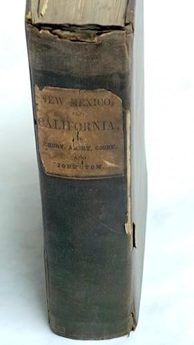
Añadir al carritoOriginal Cloth. Condición: Good. Estado de la sobrecubierta: Not Issued. First Edition. House Exec. Doc. No. 41, 30th Congress, 1st Session. Howes E 145 (1st issue). Original brown cloth, lettered in gilt. Lacks both flyleaves and title page, opens directly onto Secretary of War W. L. Marcy's letter dated 9 Feb. 1848 (p. 3), thus 3-614 pp., collated and complete except as noted with (64) lithographic plates including (26) in Emory's report, (14) botanical illustrations accompanying Engelmann's report, and (24) in Abert's report, plus (3) battle plan maps also in Emory between pp. 108-120. House edition (i.e. first issue), far more scarce than the (second issue) Senate edition (which was only 416 pp.), with possibly the first known rendering of Santa Fe on the plate opposite p. 419. Lacking the (2) folding maps and the large folding map which may not yet have been available upon issue (see Howes E 145 note). Considerable wear, but mostly intact. Cloth is somewhat soiled and spotted, with exposure at corners, chipped at tail of spine with some separation along joints and approx. 1" of minor loss along lower front joint, small vintage paper label mounted on upper spine (though not otherwise marked as an institutional copy). Signed on front pastedown and along top edge of p. 3 by former owner H. W. Clapham, a page in the U.S. House of Representatives, Washington, D.C., 1848-49. Front hinge shows some evidence of amateur repair, but the binding is still intact, all leaves and plates present and firmly anchored excepting pp. 71-74 (which, along with 3 adjacent plates, are partially detached but fully intact). Text block edges somewhat dulled by age, interior with light scattered foxing, engraved plates mostly clean also with light foxing. Scarce edition. CONTENTS: 1) Notes of a Military Reconnoissance from Fort Leavenworth, in Missouri, to San Diego, in California, Including Part of the Arkansas, Del Norte, and Gila Rivers / 2) Report of Lieut. J. W. Abert, of his Examination of New Mexico, in the Years 1846-47 / 3) Report of Lieut. Col. P. St. George Cooke of his March from Santa Fe, New Mexico, to San Diego, Upper California / 4) Journal of Captain A. R. Johnston, First Dragoons. Size: 8vo - over 7¾" - 9¾" tall. Book.
-
![Imagen del vendedor de Notes of a Military Reconnaissance, from Fort Leavenworth, in Missouri, to San Diego, in California, Including Parts of the Arkansas, Del Norte, and Gila Rivers 13th Congress, 1st Session. Ex. Doc. No. 41. [Includes Reports of Lieut. J. W. Abert, Lieut. Col. P. St. George Cooke, Journal of Capt. A. R. Johnson. ] a la venta por G. F. Wilkinson Books, member IOBA](https://pictures.abebooks.com/inventory/md/md31523545697.jpg)
Notes of a Military Reconnaissance, from Fort Leavenworth, in Missouri, to San Diego, in California, Including Parts of the Arkansas, Del Norte, and Gila Rivers 13th Congress, 1st Session. Ex. Doc. No. 41. [Includes Reports of Lieut. J. W. Abert, Lieut. Col. P. St. George Cooke, Journal of Capt. A. R. Johnson. ]
Publicado por Wendell and Van Benthuysen, Printers, Washington, D. C., 1848
Librería: G. F. Wilkinson Books, member IOBA, GRASS VALLEY, CA, Estados Unidos de America
Miembro de asociación: IOBA
Calificación del vendedor: 4 de 5 estrellas

EUR 397,52
Envío por EUR 3,42
Se envía dentro de Estados Unidos de AmericaCantidad disponible: 1 disponibles
Añadir al carritoHardcover. Condición: Poor. Joint split with spine laid down, chipped at edges; rubbing to edges and bumped corners; front endpaper torn; owner signature second endpaper, two bookplates, one for Frederick Wm. Zimmerman, one for Alfred I. Exberg. Hinge starting lower 2 inches at title page, but cord binding holding firm. First folding map of New Mexico with tape repairs to back; degrees of foxing in general to text pages and plates from mild to moderate, occasionaly heavy, yet many pages and plates remain relatively clean. ; Original brown cloth, and paper spine label; 4 sketches; 26 plates; 10 of 12 botanical plates called for, also lacking 2 botanical plates called for in appendix. Abert's report with 23 of 24 plates, lacking Pueblo de Santa Ana; 2 folding maps. Conforms to Wagner-Camp 148: 5. ; 8vo 8" - 9" tall; 614 pages.
-
Notes of a Military Reconnaissance, from Fort Leavenworth, in Missouri, to San Diego, in California, Including Parts of the Arkansas, Del Norte, and Gila Rivers 13th Congress, 1st Session. Ex. Doc. No. 41. [Includes Reports of Lieut. J. W. Abert, Lieut. Col. P. St. George Cooke, Journal of Capt. A. R. Johnson. ]
Publicado por WashDC: Wendell and Van Benthuysen, Printers, 1848
Librería: Ethnographics, Georgetown, TX, Estados Unidos de America
Calificación del vendedor: 3 de 5 estrellas

Original o primera edición
EUR 441,69
Envío por EUR 2,57
Se envía dentro de Estados Unidos de AmericaCantidad disponible: 1 disponibles
Añadir al carritoHardcover. Condición: Very Good. No Jacket. 1st Edition. 1stedn; THIRTIETH CONGRESS, FIRST SESSION - EX. DOC. NO. 41; lg8vo blue cloth bds, gilt spine titles; rebacked with orig ptdwraps preserved, pp433ff has nibbling and water staining to extreme bottom page corners but not affecting text, ow VG/ndj: 11+614pp, many tables, bw plates and intext illus; First edition, House of Representatives issues of the report, containing the reports of Lieutenant Abert, Colonel Cooke, and Captain Johnson as well as that of Emory; the Senate issue only contained the Emory report; with [this copy only contains 1 of 2 folding maps, The large foldout map of the Territory of New Mexico is MISSING but the large foldout sketch of the march and wagon road of Lt. Colonel Cooke is PRESENT and attached toward the rear of the book. At the start of the Mexican War, Emory was selected to join General Stephen Watts Kearny and the Army of the West (1846) to take New Mexico and California. Along the way he kept a detailed journal of the march down the Rio Grande and across to the Gila River, and down it to its mouth on the Colorado River, then to the Pacific Coast. It became an important guide book for the road to Southern California. This report described terrain and rivers, cities and forts and made observations about Native Americans, Mexicans, primarily in future New Mexico Territory, Arizona Territory and Southern California. It was and is considered one of the important chronicles and descriptions of the historic Southwest, particularly noted for its maps. [wikipedia];Zamorano Eighty 33: "Emory's report contains numerous folding maps of the areas described, and 64 lithograph plates of views and of botanical and natural history subjects. It is source material for the Southwest and the Mexican border. A library of Western Americana is incomplete without it." Howes E145: "That the House edition has priority is indicated by the fact that many copies were seemingly issued before the large map was available.". Thirtieth Congress - Senate Executive No. 7, 30th Congress First Session. (Cowan page 195; (Cowan p.195; Graff 1249; Howes E145; Wagner-Camp 148:2; Zamorano Eighty 33) First edition. In 1844, Emory served in an expedition that produced a new map of Texan claims westward to the Rio Grande. He came to public attention as the author of the Notes of a Military Reconnaissance from Fort Leavenworth in Missouri to San Diego, California, published by the Thirtieth United States Congress in 1848. This report described terrain and rivers, cities and forts and made observations about Indians, Mexicans, primarily in New Mexico Territory, Arizona Territory and Southern California. It was and is considered one of the important chronicles and descriptions of the historic Southwest, particularly noted for its maps. Emory was a reliable and conscientious cartographer. There is a story of testament as to Emory s dedication to accuracy that says John Bartlett his supervisor in the Corps of Topographical Engineers made him sign off on a misplaced boundary marker, creating a sweet revenge for Emory who replaced him as Head of the International Boundary Commission in 1855. So accurate were his maps that when topographical engineers were surveying possible routes for the transcontinental railroad the most Southern route did not need to be surveyed thanks to the outstanding work by William H. Emory.
-
NOTES OF A MILITARY RECONNOISSANCE, from FORT LEAVENWORTH, IN MISSOURI, TO SAN DIEGO, IN CALIFORNIA
Publicado por Wendell and Van Benthuysen, Printers, Washington, 1848
Librería: Frey Fine Books, Rougemont, NC, Estados Unidos de America
Calificación del vendedor: 5 de 5 estrellas
Original o primera edición
EUR 2.208,46
Envío por EUR 5,96
Se envía dentro de Estados Unidos de AmericaCantidad disponible: 1 disponibles
Añadir al carritoCloth. Condición: Very Good +. 1st edition. 1st edition. A Very Good + copy. 8vo., 614 pp., illustrated with 64 engraved plates and Two large folding maps attached: "Map of Territory of New Mexico" by Kearney's Report ("under instruction from Emory") 1846-47 and "Sketch of part of the march & wagon road of Lt. Colonel Cooke from Santa Fe to the Pacific Ocean 1846-47"by Cooke's Report. Laid in, is a very large (7 foot long) map, titled: "Military Reconnaissance of the Arkansas, Rio Del Norte and Rio Gila. by W. H. Emory". Bound in the original brown cloth with paper title label on the spine. A very clean copy, with plates vibrant, with rich blacks and no spotting or soiling. Maps are also very clean, with very little (if any) breaks along the folds. Lower front tip bumped. Some browning to the paste downs. A Superior copy. Howes E-145. Thirtieth Congress- First Session. Ex. Doc. No. 41. Includes the reports of J.W. Abert and Philip St. George Cooke. Together they summarize the activity of the U.S. Army to the west of Santa Fe after the capture of New Mexico by the Army of the West. This work is considered one of the important chronicles and descriptions of the historic Southwest.
-
Notes of a Military Reconnoissance, from Fort Leavenworth, in Missouri, to San Diego, in California, Including Part of the Arkansas, Del Norte, and Gila Rivers; AND, Report of Lieut. J. W. Abert; AND, Cook's March from Santa Fe; AND, Journal of Johnston
Publicado por Wendell and Van Benthuysen., Washington, 1848
Librería: Ziern-Hanon Galleries, Frontenac, MO, Estados Unidos de America
Calificación del vendedor: 1 de 5 estrellas

Original o primera edición
EUR 1.011,48
Envío por EUR 4,72
Se envía dentro de Estados Unidos de AmericaCantidad disponible: 1 disponibles
Añadir al carritoFull Cloth. Condición: Good. First Edition. FIRST EDITION. House of Representatives Edition which proceeds the Senate edition. Title page mistakenly lists Emory as "Lieut. Col.". Original dark brown cloth with paper label title "New Mexico, and California, by Emory, Abert, Cooke, and Johnston". Contains some scuffs and nicks. Right spine edge is loose. Pages are age-toned and stiff with a few foxed. Includes wonderful pen and ink drawings in fine condition. Two fold out maps and three maps of battles in California with the Mexicans. Large fold-out map with 5" tear from inner margin affecting the map, "The Territory of New Mexico, 1846-47"; 67 plates. Page 454 misprinted as 754. 614pp. Overall GOOD minus condition. Extreemely scarce first edition. Damp staining to bottom corner throughout. Previous owner's notes on first page from 1929. Includes the reports of J.W. Abert and Philip St. George Cooke. Together they summarize the activity of the U.S. Army to the west of Santa Fe after the capture of New Mexico by the Army of the West. The first folding map is Philip St. George Cooke's "Sketch of Part of the march & Wagon road of Lt. Colonel Cooke, from Santa Fe to the Pacific Ocean, 1846-7." This shows the route of the Mormon Battalion from Santa Fe to the Gila River. The other, "Map of the Territory of New Mexico," was compiled by Lieutenants Abert and Peck after the conquest of New Mexico. Both are important contributions to western cartography. Abert's report includes material on the Indians of New Mexico and their languages. The Abert report also includes all of his views of New Mexico, the best group of early New Mexico views published. Wagner-Camp is in error in its collation of this edition, mistakenly calling for only forty plates, plus those of the Abert report. William Hemsley Emory (September 7, 1811 -- December 1, 1887) was an United States Army officer and surveyor of Texas. Emory was born in Queen Anne's County, Maryland, on his family's "Poplar Grove" estate. He attended the United States Military Academy at West Point, New York, and graduated in 1831. Assigned as a second lieutenant, he served in the Corps of Engineers until he resigned from the service in 1836 to pursue civil engineering, but he returned to the service in 1838.During that same year, he married a great-grandaughter of Benjamin Franklin, Matilda Wilkins Bache of Philadelphia. The couple would have three children. During his second stint in the army, he was successively promoted from lieutenant to captain and finally to major. He specialized in mapping the United States border, including the Texas-Mexico border, the United States-Canadian border(18441866) and the Gadsen Purchase (1854 -- 1857). In 1844, Emory served in an expedition that produced a new map of Texan claims westward to the Rio Grande River. He came to public attention as the author of the Notes of a Military Reconnaissance from Fort Leavenworth in Missouri to San Diego, California, published by the Thirtieth United States Congress in 1848. This report described terrain and rivers, cities and forts and made observations about Indians, Mexicans, primarily in New Mexico Territory, Arizona Territory and Southern California. It was and is considered one of the important chronicles and descriptions of the historic Southwest, particularly noted for its maps. Emory was a reliable and conscientous cartographer. Size: 8vo - over 7¾" - 9¾" tall. Hardcover.