
Importe total (1 artículo artículos):
Destino del pedido:

langenes barent (109 resultados)
Ir a los resultados principales
Filtros de búsqueda
Tipo de artículo
- Todos los tipos de productos
- Libros (12)
- Revistas y publicaciones (No hay ningún otro resultado que coincida con este filtro.)
- Cómics (No hay ningún otro resultado que coincida con este filtro.)
- Partituras (No hay ningún otro resultado que coincida con este filtro.)
- Arte, grabados y pósters (15)
- Fotografías (No hay ningún otro resultado que coincida con este filtro.)
- Mapas (82)
- Manuscritos y coleccionismo de papel (No hay ningún otro resultado que coincida con este filtro.)
Condición Más información
- Nuevo (9)
- Como nuevo, Excelente o Muy bueno (2)
- Bueno o Aceptable (3)
- Regular o Pobre (No hay ningún otro resultado que coincida con este filtro.)
- Tal como se indica (95)
Encuadernación
- Todas
- Tapa dura (9)
- Tapa blanda (No hay ningún otro resultado que coincida con este filtro.)
Más atributos
- Primera edición (49)
- Firmado (No hay ningún otro resultado que coincida con este filtro.)
- Sobrecubierta (No hay ningún otro resultado que coincida con este filtro.)
- Con imágenes (105)
- No impresión bajo demanda (103)
Idioma (3)
Gastos de envío gratis
Ubicación del vendedor
Valoración de los vendedores
-

Caert-thresoor, inhoudende de tafelen des gantsche werelts landen met beschryvingen verlicht . 1598
Librería: Books Puddle, New York, NY, Estados Unidos de America
Calificación del vendedor: 4 de 5 estrellas

EUR 35,91
Envío por EUR 3,49
Se envía dentro de Estados Unidos de AmericaCantidad disponible: 4 disponibles
Ańadir al carritoCondición: New. pp. 675.
-
Caert-thresoor, inhoudende de tafelen des gantsche werelts landen met beschryvingen verlicht . 1598
Librería: Majestic Books, Hounslow, Reino Unido
Calificación del vendedor: 4 de 5 estrellas
EUR 34,72
Envío por EUR 7,65
Se envía de Reino Unido a Estados Unidos de AmericaCantidad disponible: 4 disponibles
Ańadir al carritoCondición: New. pp. 675.
-
Caert-thresoor, inhoudende de tafelen des gantsche werelts landen met beschryvingen verlicht . 1598
Librería: Biblios, Frankfurt am main, HESSE, Alemania
Calificación del vendedor: 4 de 5 estrellas
EUR 35,69
Envío por EUR 9,95
Se envía de Alemania a Estados Unidos de AmericaCantidad disponible: 4 disponibles
Ańadir al carritoCondición: New. pp. 675.
-

Insulae Canariae ol: Fortunatae / d'Eylanden van Canarien
Librería: Antiquariat Lang, Rennerod, Alemania
Calificación del vendedor: 4 de 5 estrellas
EUR 40,00
Envío por EUR 15,00
Se envía de Alemania a Estados Unidos de AmericaCantidad disponible: 1 disponibles
Ańadir al carritoHandkolorierter Orig.-Kupferstich. ( Thresor de Chartes, um 1600 ). - Motiv: 8,3 x 12 auf Blatt: 10,8 x 15,8. * Diese Karte der Kanarischen Inseln enthält einen Ausschnitt des Hafens von Las Palmas (links oben), der ein Zwischenstopp für die spanischen Eroberer, Händler und Missionare auf ihrem Weg in die Neue Welt war. Niederländischer Text auf der Rückseite. Die Karte wurde erstmals von Cornelius Claesz veröffentlicht und von Barent Langenes in der Ausgabe von 1598 gedruckt. - This map of the Canary Islands includes an inset of the Port of Las Palmas, a stopping point for the Spanish conquerors, traders, and missionaries on their way to the New World. Netherlands text on verso. The map was first published by Cornelius Claesz and printed by Barent Langenes in the 1598 edition. - References: King (2nd ed.) pp. 80-82; Van der Krogt (Vol. III) #8970:341.
-
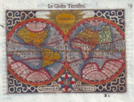
Le Globe Terrestre (alter, handkolorierter Kupferstich).
Idioma: Francés
Publicado por ohne Jahresangabe (ca. 1590)., 1590
Librería: Antiquariat ExLibris Erlach Eberhard Ott, Ochsenfurt - Erlach, BY, Alemania
Miembro de asociación: GIAQ
Calificación del vendedor: 5 de 5 estrellas

EUR 220,00
Envío por EUR 9,95
Se envía de Alemania a Estados Unidos de AmericaCantidad disponible: 1 disponibles
Ańadir al carritoAlter, handkolorierter Kupferstich aus Thresor De Chartes, Contenant Les Tableaux De Tous Les Pays Du Monde : enrichi de belles descriptions, reveu & augmenté Autor / Hrsg.: Langenes, Barent ; Claesz, Cornelis ; La Haye, Jean de ; Langenes, Barent ; Claesz, Cornelis ; La Haye, Jean de Verlagsort: [Amsterdam] | Erscheinungsjahr: 1602 | Verlag: Christoffle Guyot. Hier auch Stiche von Pieter van der Keere (Petrus Kaerius / Kerius), Rückseite paginiert und mit Text bedruckt "Description du Globe Terrestre". Handgeschöpftes Büttenpapier. Blatt professionell gereinigt und nachkoloriert. Professionell gerahmt mit Passepartout. Zahlreiche weitere Detailkarten (noch ungerahmt) verfügbar, z.B. Europe, Poloigne, Asie, Afrique, Le nouveau Monde, Engleterre (Anglia), Cambria ou Wallia, Escosse (Scotia), Irlande (Hibernia), Espaigne (Hispania), Valence (Valentia), Calis Malis (Baia de Cadiz), Mallorque & Minorque (Majorca, Minorca), Portugal (Portugallia). Abbildungen auf Anfrage. wikipedia Pieter van den Keere, ou Petrus Kaerius en latin, est un graveur et cartographe néerlandais né en 1571 ŕ Gand et mort en 1646 ŕ 75 ans. Sprache: Französisch Gewicht in Gramm: 1001 Blattgröße 12 x18, Bild 8,5 x 12,3 cm. Thresor de Chartes, contenant les tableaux de tous les pays du monde, enrichi de belles descriptions, entre 1598 et 1602.
-

Helvetia
Publicado por Amsterdam, 1608
Librería: libreria antiquaria perini Sas di Perini, Verona, VR, Italia
Miembro de asociación: ALAI ILAB
Calificación del vendedor: 5 de 5 estrellas
Arte / Grabado / Póster
EUR 120,00
Envío por EUR 40,00
Se envía de Italia a Estados Unidos de AmericaCantidad disponible: 1 disponibles
Ańadir al carritoIncisione in rame, dipinta a mano, mm 86x126 su foglio mm 121x176, tratta da una edizione con testo francese dellíopera ěTabulae geographicae contractaeî pubblicata col titolo ěThresor de chartes, contenant les tableaux de tous les pays du Mondeî col testo tradotto in francese da I. de la Haye. Buon esemplare con due piccoli fori Nr.cat: Cod 35147.
-

Candia
Publicado por Amsterdam, 1608
Librería: libreria antiquaria perini Sas di Perini, Verona, VR, Italia
Miembro de asociación: ALAI ILAB
Calificación del vendedor: 5 de 5 estrellas
Arte / Grabado / Póster
EUR 130,00
Envío por EUR 40,00
Se envía de Italia a Estados Unidos de AmericaCantidad disponible: 1 disponibles
Ańadir al carritoIncisione in rame, dipinta a mano, mm 87x126 su foglio mm 122x176, testo francese, tratta da "Tabulae geographicae contractae". Buon esemplare, foglio ingiallito. Nr.cat: Cod 0226.
-

Marcha Anconae olim Picenum. 1572
Publicado por Amsterdam, 1610
Librería: libreria antiquaria perini Sas di Perini, Verona, VR, Italia
Miembro de asociación: ALAI ILAB
Calificación del vendedor: 5 de 5 estrellas
Arte / Grabado / Póster
EUR 150,00
Envío por EUR 40,00
Se envía de Italia a Estados Unidos de AmericaCantidad disponible: 1 disponibles
Ańadir al carritoIncisione in rame di Pieter Kaerius, dipinta a mano, mm 87x126 su foglio mm 120x190, tratta da una edizione tedesca di "Tabulae geographicae contractae". Ottimo esemplare. Rara carta geografica per la prima volta pubblicata nel "Caert-thresoor" di Barent Langenes edito ad Amstredam da Cornelis Claesz nel 1598. Esemplare da una successiva ristampa non identificata con testo tedesco di inizio '600. Alla fine del XVI secolo il pi? famoso e commercializzato atlante ětascabileî era líEpitome ' di Abraham Ortelius. Nel 1598 gli editori Barent Langenes e Cornelis Claesz diedero alle stampe una raccolta di superiore qualit? Le lastre sono affidate ad abili intagliatori quali Pieter Kaerius e Jodocus Hondius. Bibliografia King, ' Miniature Antique Maps, ' pp. 80-82. Nr.cat: Cod 1790.
-

Chili et Patagonum regio
Publicado por Amsterdam, 1608
Librería: libreria antiquaria perini Sas di Perini, Verona, VR, Italia
Miembro de asociación: ALAI ILAB
Calificación del vendedor: 5 de 5 estrellas
Arte / Grabado / Póster
EUR 150,00
Envío por EUR 40,00
Se envía de Italia a Estados Unidos de AmericaCantidad disponible: 1 disponibles
Ańadir al carritoIncisione in rame, dipinta a mano, mm 87x126 su foglio mm 121x176, tratta da una edizione con testo francese dell'opera "Tabulae geographicae contractae" pubblicata col titolo "Thresor de chartes, contenant les tableaux de tous les pays du Monde" col testo tradotto in francese da I. de la Haye. Buon esemplare.
-
Rhodos: Rhodi Rodes 1598
Publicado por Langenes, Middelburg
Librería: Antiquariat Vlma, Herbrechtingen, Alemania
Calificación del vendedor: 2 de 5 estrellas

Mapa Original o primera edición
EUR 179,00
Envío por EUR 29,95
Se envía de Alemania a Estados Unidos de AmericaCantidad disponible: 1 disponibles
Ańadir al carritoKein Einband. Condición: Gut. 1. Auflage. Karte von Rhodos! Map from Rhodos! very rare, first edition. Engraving by Petrus Kaerius. It is a copy of the very first edition of the "Caert-Thresoor, .", published in Middelburg in 1598 by Barent Langenes. Some spots in the margins. Verso: Dutch text. Old coloured. Very nice! complete 16,5x11cm. Kleinformat.
-

Elba
Publicado por Amsterdam, 1608
Librería: libreria antiquaria perini Sas di Perini, Verona, VR, Italia
Miembro de asociación: ALAI ILAB
Calificación del vendedor: 5 de 5 estrellas
Arte / Grabado / Póster
EUR 180,00
Envío por EUR 40,00
Se envía de Italia a Estados Unidos de AmericaCantidad disponible: 1 disponibles
Ańadir al carritoIncisione in rame, dipinta a mano, mm 83x123 su foglio mm 121x176, tratta da una edizione con testo francese dell'opera "Tabulae geographicae contractae" pubblicata col titolo "Thresor de chartes, contenant les tableaux de tous les pays du Monde" col testo tradotto in francese da I. de la Haye. Buon esemplare. Lievi aloni marginali in alto. Nr.cat: Cod 34726.
-

Brasilia
Publicado por Amsterdam, 1608
Librería: libreria antiquaria perini Sas di Perini, Verona, VR, Italia
Miembro de asociación: ALAI ILAB
Calificación del vendedor: 5 de 5 estrellas
Arte / Grabado / Póster
EUR 180,00
Envío por EUR 40,00
Se envía de Italia a Estados Unidos de AmericaCantidad disponible: 1 disponibles
Ańadir al carritoIncisione in rame, dipinta a mano, mm 83x123 su foglio mm 121x176, tratta da una edizione con testo francese dell'opera "Tabulae geographicae contractae" pubblicata col titolo "Thresor de chartes, contenant les tableaux de tous les pays du Monde" col testo tradotto in francese da I. de la Haye. Buon esemplare. Foglio un po' irregolare. Nr.cat: Cod 34727.
-

Ischia insula
Publicado por Amsterdam, 1608
Librería: libreria antiquaria perini Sas di Perini, Verona, VR, Italia
Miembro de asociación: ALAI ILAB
Calificación del vendedor: 5 de 5 estrellas
Arte / Grabado / Póster
EUR 180,00
Envío por EUR 40,00
Se envía de Italia a Estados Unidos de AmericaCantidad disponible: 1 disponibles
Ańadir al carritoIncisione in rame, dipinta a mano, mm 83x123 su foglio mm 121x176, tratta da una edizione con testo francese dell'opera "Tabulae geographicae contractae" pubblicata col titolo "Thresor de chartes, contenant les tableaux de tous les pays du Monde" col testo tradotto in francese da I. de la Haye. Buon esemplare. Lievi aloni marginali in alto. Stampata un po' irregolarmente sul foglio.
-

Larius Lacus
Publicado por Amsterdam, 1608
Librería: libreria antiquaria perini Sas di Perini, Verona, VR, Italia
Miembro de asociación: ALAI ILAB
Calificación del vendedor: 5 de 5 estrellas
Arte / Grabado / Póster
EUR 180,00
Envío por EUR 40,00
Se envía de Italia a Estados Unidos de AmericaCantidad disponible: 1 disponibles
Ańadir al carritoIncisione in rame, dipinta a mano, mm 83x123 su foglio mm 121x176, firmata in basso "P. Kaerius sculp.", tratta da una edizione con testo francese dell'opera "Tabulae geographicae contractae" pubblicata col titolo "Thresor de chartes, contenant les tableaux de tous les pays du Monde" col testo tradotto in francese da I. de la Haye. Buon esemplare con un forellino di tarlo nel margine destro. Lievi aloni marginali in alto. Stampata un po' irregolarmente sul foglio Nr.cat: Cod 34724.
-

(Celestial Map) Le Globe Celeste
Publicado por France, 1609
Librería: Hornseys, Ripon, Reino Unido
Miembro de asociación: PBFA
Calificación del vendedor: 5 de 5 estrellas
EUR 212,07
Envío por EUR 29,41
Se envía de Reino Unido a Estados Unidos de AmericaCantidad disponible: 1 disponibles
Ańadir al carritoNo Binding. Condición: Good. 1st edition thus. Original copper engraving. Date: 1609. Sheet size: 16.8cm x 10.6cm. From 'Thresor de Chartes, contenant les Tableaux de tous les Pays du Monde'. Based on the celestial map from Ortelius' Epitome. Text in French to the verso. Early, but not original hand-colouring. A little dusty and with staining to the margins else in good, clean condition. Very scarce.
-

Fretum Magellanicum
Publicado por Amsterdam, 1608
Librería: libreria antiquaria perini Sas di Perini, Verona, VR, Italia
Miembro de asociación: ALAI ILAB
Calificación del vendedor: 5 de 5 estrellas
Arte / Grabado / Póster
EUR 200,00
Envío por EUR 40,00
Se envía de Italia a Estados Unidos de AmericaCantidad disponible: 1 disponibles
Ańadir al carritoncisione in rame, dipinta a mano, mm 87x124 su foglio mm 121x176, tratta da una edizione con testo francese dellíopera ěTabulae geographicae contractaeî pubblicata col titolo ěThresor de chartes, contenant les tableaux de tous les pays du Mondeî col testo tradotto in francese da I. de la Haye. Buon esemplare Nr.cat: Cod 35144.
-

Corsica
Publicado por Amsterdam, 1608
Librería: libreria antiquaria perini Sas di Perini, Verona, VR, Italia
Miembro de asociación: ALAI ILAB
Calificación del vendedor: 5 de 5 estrellas
Arte / Grabado / Póster
EUR 200,00
Envío por EUR 40,00
Se envía de Italia a Estados Unidos de AmericaCantidad disponible: 1 disponibles
Ańadir al carritoIncisione in rame, dipinta a mano, mm 87x122 su foglio mm 121x183, tratta da una edizione con testo francese dellíopera ěTabulae geographicae contractaeî pubblicata col titolo ěThresor de chartes, contenant les tableaux de tous les pays du Mondeî col testo tradotto in francese da I. de la Haye. Buon esemplare Nr.cat: Cod 35143.
-

Hibernia
Publicado por Amsterdam, 1608
Librería: libreria antiquaria perini Sas di Perini, Verona, VR, Italia
Miembro de asociación: ALAI ILAB
Calificación del vendedor: 5 de 5 estrellas
Arte / Grabado / Póster
EUR 220,00
Envío por EUR 40,00
Se envía de Italia a Estados Unidos de AmericaCantidad disponible: 1 disponibles
Ańadir al carritoIncisione in rame, dipinta a mano, mm 87x126 su foglio mm 121x176, tratta da una edizione con testo francese dellíopera ěTabulae geographicae contractaeî pubblicata col titolo ěThresor de chartes, contenant les tableaux de tous les pays du Mondeî col testo tradotto in francese da I. de la Haye. Buon esemplare seppur rinforzato al verso con due strappetti restaurati. Nr.cat: Cod 35042.
-

Europe
Publicado por Amsterdam, 1608
Librería: libreria antiquaria perini Sas di Perini, Verona, VR, Italia
Miembro de asociación: ALAI ILAB
Calificación del vendedor: 5 de 5 estrellas
Arte / Grabado / Póster
EUR 220,00
Envío por EUR 40,00
Se envía de Italia a Estados Unidos de AmericaCantidad disponible: 1 disponibles
Ańadir al carritoIncisione in rame, dipinta a mano, mm 87x126 su foglio mm 121x176, tratta da una edizione con testo francese dell'opera "Tabulae geographicae contractae" pubblicata col titolo "Thresor de chartes, contenant les tableaux de tous les pays du Monde" col testo tradotto in francese da I. de la Haye. Buon esemplare seppur un po' rifilato il margine sup. (al verso si evidenzia una parziale rifilatura del titolo e del numero di pagina).
-

LíAmerique du coste du Midi
Publicado por Amsterdam, 1608
Librería: libreria antiquaria perini Sas di Perini, Verona, VR, Italia
Miembro de asociación: ALAI ILAB
Calificación del vendedor: 5 de 5 estrellas
Arte / Grabado / Póster
EUR 280,00
Envío por EUR 40,00
Se envía de Italia a Estados Unidos de AmericaCantidad disponible: 1 disponibles
Ańadir al carritoIncisione in rame, dipinta a mano, mm 85x124 su foglio mm 121x180, tratta da una edizione con testo francese dellíopera ěTabulae geographicae contractaeî pubblicata col titolo ěThresor de chartes, contenant les tableaux de tous les pays du Mondeî col testo tradotto in francese da I. de la Haye. Buon esemplare Nr.cat: Cod 35146.
-

Nova Guinea et in. Salomonis
Publicado por Amsterdam, 1608
Librería: libreria antiquaria perini Sas di Perini, Verona, VR, Italia
Miembro de asociación: ALAI ILAB
Calificación del vendedor: 5 de 5 estrellas
Arte / Grabado / Póster
EUR 340,00
Envío por EUR 40,00
Se envía de Italia a Estados Unidos de AmericaCantidad disponible: 1 disponibles
Ańadir al carritoIncisione in rame, dipinta a mano, mm 86x126 su foglio mm 121x176, tratta da una edizione con testo francese dellíopera ěTabulae geographicae contractaeî pubblicata col titolo ěThresor de chartes, contenant les tableaux de tous les pays du Mondeî col testo tradotto in francese da I. de la Haye. Buon esemplare Nr.cat: Cod 34145.
-

Terra nova
Publicado por Amsterdam, 1608
Librería: libreria antiquaria perini Sas di Perini, Verona, VR, Italia
Miembro de asociación: ALAI ILAB
Calificación del vendedor: 5 de 5 estrellas
Arte / Grabado / Póster
EUR 350,00
Envío por EUR 40,00
Se envía de Italia a Estados Unidos de AmericaCantidad disponible: 1 disponibles
Ańadir al carritoIncisione in rame, dipinta a mano, mm 87x126 su foglio mm 122x176, testo francese, tratta da "Tabulae geographicae contractae". Buon esemplare, qualche lieve macchie e piccolo alone Nr.cat: Cod 0225.
-

Saxonia Thuringia Misnia.
Ańo de publicación: 1599
Librería: Altea Antique Maps, London, Reino Unido
Miembro de asociación: ABA ILAB PBFA
Calificación del vendedor: 5 de 5 estrellas
Mapa Original o primera edición
EUR 60,59
Envío por EUR 41,18
Se envía de Reino Unido a Estados Unidos de AmericaCantidad disponible: 1 disponibles
Ańadir al carrito1st Edition. Amsterdam, Cornelis Claez, 1599, Dutch text edition. 85 x 125, with letterpress surtitle and pagination. Some paper toning. A scarce map of Saxony, Thuringia & Meissen, engraved by either Pieter van den Keere or Jodocus Hondius for the 1598 'Caert-Thresoor', with a text by an unknown author. Despite being published a year after the first edition, this is a second state: the right border has been re-engraved with latitude graduations. In 1600 this map was being published in the 'Tabularum Geographicarum' with a text by Petrus Bertius, and in 1616 a new plate was engraved by Jodocus Hondius II, slightly larger and with wider borders with scales of longitude and latitude.
-

Westphalia.
Ańo de publicación: 1599
Librería: Altea Antique Maps, London, Reino Unido
Miembro de asociación: ABA ILAB PBFA
Calificación del vendedor: 5 de 5 estrellas
Mapa Original o primera edición
EUR 60,59
Envío por EUR 41,18
Se envía de Reino Unido a Estados Unidos de AmericaCantidad disponible: 1 disponibles
Ańadir al carrito1st Edition. Amsterdam, Cornelis Claez, 1599, Dutch text edition. 85 x 125, with letterpress surtitle and pagination. Some damp staining. A scarce map of Westphalia, orientated with north to the left, engraved by either Pieter van den Keere or Jodocus Hondius for the 1598 'Caert-Thresoor', with a text by an unknown author. Despite being published a year after the first edition, this is a second state: the top border has been re-engraved with latitude graduations. In 1600 this map was being published in the 'Tabularum Geographicarum' with a text by Petrus Bertius, and in 1616 a new plate was engraved by Jodocus Hondius II, slightly larger and with wider borders with scales of longitude and latitude.
-

Burgundiae Com.
Ańo de publicación: 1599
Librería: Altea Antique Maps, London, Reino Unido
Miembro de asociación: ABA ILAB PBFA
Calificación del vendedor: 5 de 5 estrellas
Mapa Original o primera edición
EUR 60,59
Envío por EUR 41,18
Se envía de Reino Unido a Estados Unidos de AmericaCantidad disponible: 1 disponibles
Ańadir al carrito1st Edition. Amsterdam, Cornelis Claez, 1599, Dutch text edition. 85 x 125, with letterpress surtitle and pagination. Faint damp stains. A scarce map of Franche-Comté, orientated with north to the left, engraved by either Pieter van den Keere or Jodocus Hondius for the 1598 'Caert-Thresoor', with a text by an unknown author. Despite being published a year after the first edition, this is a second state: the top border has been re-engraved with latitude graduations. In 1600 this map was being published in the 'Tabularum Geographicarum' with a text by Petrus Bertius, and in 1616 a new plate was engraved by Jodocus Hondius II, slightly larger and with wider borders with scales of longitude and latitude.
-

Hannonia,
Ańo de publicación: 1599
Librería: Altea Antique Maps, London, Reino Unido
Miembro de asociación: ABA ILAB PBFA
Calificación del vendedor: 5 de 5 estrellas
Mapa
EUR 60,59
Envío por EUR 41,18
Se envía de Reino Unido a Estados Unidos de AmericaCantidad disponible: 1 disponibles
Ańadir al carritoAmsterdam, Cornelis Claez, 1599, Dutch text edition. 85 x 125, with letterpress surtitle and pagination. Faint damp stains. A scarce map of Hainaut, engraved by either Pieter van den Keere or Jodocus Hondius for the 1598 'Caert-Thresoor', with a text by an unknown author. In 1600 this map was being published in the 'Tabularum Geographicarum' with a text by Petrus Bertius, and in 1616 a new plate was engraved by Jodocus Hondius II, slightly larger and with wider borders with scales of longitude and latitude.
-

Picardia.
Ańo de publicación: 1599
Librería: Altea Antique Maps, London, Reino Unido
Miembro de asociación: ABA ILAB PBFA
Calificación del vendedor: 5 de 5 estrellas
Mapa Original o primera edición
EUR 60,59
Envío por EUR 41,18
Se envía de Reino Unido a Estados Unidos de AmericaCantidad disponible: 1 disponibles
Ańadir al carrito1st Edition. Amsterdam, Cornelis Claez, 1599, Dutch text edition. 85 x 125, with letterpress surtitle and pagination. Faint damp stains. A scarce map of south Picardy, marking Amiens, engraved by either Pieter van den Keere or Jodocus Hondius for the 1598 'Caert-Thresoor', with a text by an unknown author. Despite being published a year after the first edition, this is a second state: the lateral borders have been re-engraved with latitude graduations. In 1600 this map was being published in the 'Tabularum Geographicarum' with a text by Petrus Bertius, and in 1616 a new plate was engraved by Jodocus Hondius II, slightly larger and with wider borders with scales of longitude and latitude.
-

Veromadui.
Ańo de publicación: 1599
Librería: Altea Antique Maps, London, Reino Unido
Miembro de asociación: ABA ILAB PBFA
Calificación del vendedor: 5 de 5 estrellas
Mapa
EUR 60,59
Envío por EUR 41,18
Se envía de Reino Unido a Estados Unidos de AmericaCantidad disponible: 1 disponibles
Ańadir al carritoAmsterdam, Cornelis Claez, 1599, Dutch text edition. 85 x 125, with letterpress surtitle and pagination. Faint damp stains. A scarce map of Vermandois, part of Picardy, engraved by either Pieter van den Keere or Jodocus Hondius for the 1598 'Caert-Thresoor', with a text by an unknown author. In 1600 this map was being published in the 'Tabularum Geographicarum' with a text by Petrus Bertius, and in 1616 a new plate was engraved by Jodocus Hondius II, slightly larger and with wider borders with scales of longitude and latitude.
-

Lotharingia.
Ańo de publicación: 1599
Librería: Altea Antique Maps, London, Reino Unido
Miembro de asociación: ABA ILAB PBFA
Calificación del vendedor: 5 de 5 estrellas
Mapa Original o primera edición
EUR 60,59
Envío por EUR 41,18
Se envía de Reino Unido a Estados Unidos de AmericaCantidad disponible: 1 disponibles
Ańadir al carrito1st Edition. Amsterdam, Cornelis Claez, 1599, Dutch text edition. 85 x 125, with letterpress surtitle and pagination. Faint damp stains. A scarce map of Lorraine, orientated with north to the left, engraved by either Pieter van den Keere or Jodocus Hondius for the 1598 'Caert-Thresoor', with a text by an unknown author. Despite being published a year after the first edition, this is a second state: the bottom border has been re-engraved with latitude graduations. In 1600 this map was being published in the 'Tabularum Geographicarum' with a text by Petrus Bertius, and in 1616 a new plate was engraved by Jodocus Hondius II, slightly larger and with wider borders with scales of longitude and latitude.
-

Thiet Marsia
Ańo de publicación: 1599
Librería: Altea Antique Maps, London, Reino Unido
Miembro de asociación: ABA ILAB PBFA
Calificación del vendedor: 5 de 5 estrellas
Mapa
EUR 66,65
Envío por EUR 41,18
Se envía de Reino Unido a Estados Unidos de AmericaCantidad disponible: 1 disponibles
Ańadir al carritoAmsterdam, Cornelis Claez, 1599, Dutch text edition. 85 x 125, with letterpress surtitle and pagination. Some damp staining. A scarce map of Dithmarschen, orientated with north to the left, engraved by either Pieter van den Keere or Jodocus Hondius for the 1598 'Caert-Thresoor', with a text by an unknown author. Of interest is Büsum, shown as an island despite being connected to the mainland by the building of a dam in 1585. In 1600 this map was being published in the 'Tabularum Geographicarum' with a text by Petrus Bertius, and in 1616 a new plate was engraved by Jodocus Hondius II, slightly larger and with wider borders with scales of longitude and latitude.

