
Importe total (1 artículo artículos):
Destino del pedido:

j rapkin (483 resultados)
Ir a los resultados principales
Filtros de búsqueda
Tipo de artículo
- Todos los tipos de productos
- Libros (283)
- Revistas y publicaciones (No hay ningún otro resultado que coincida con este filtro.)
- Cómics (No hay ningún otro resultado que coincida con este filtro.)
- Partituras (No hay ningún otro resultado que coincida con este filtro.)
- Arte, grabados y pósters (2)
- Fotografías (No hay ningún otro resultado que coincida con este filtro.)
- Mapas (178)
- Manuscritos y coleccionismo de papel (20)
Condición Más información
Encuadernación
Más atributos
- Primera edición (15)
- Firmado (1)
- Sobrecubierta (No hay ningún otro resultado que coincida con este filtro.)
- Con imágenes (409)
- No impresión bajo demanda (481)
Idioma (3)
Gastos de envío gratis
Ubicación del vendedor
Valoración de los vendedores
-

A Woman Doctor's Guide to PMS: Essential Facts and Up to the Minute Information on PMS (Books for Women by Women)
Librería: Half Price Books Inc., Dallas, TX, Estados Unidos de America
Calificación del vendedor: 5 de 5 estrellas

EUR 16,57
Envío por EUR 3,05
Se envía dentro de Estados Unidos de AmericaCantidad disponible: 1 disponibles
Ańadir al carritopaperback. Condición: Very Good. Connecting readers with great books since 1972! Used books may not include companion materials, and may have some shelf wear or limited writing. We ship orders daily and Customer Service is our top priority!
-
A Woman Doctor's Guide to PMS: Essential Facts and Up to the Minute Information on PMS (Books for Women by Women)
Librería: ThriftBooks-Dallas, Dallas, TX, Estados Unidos de America
Calificación del vendedor: 5 de 5 estrellas
EUR 20,17
Gastos de envío gratis
Se envía dentro de Estados Unidos de AmericaCantidad disponible: 1 disponibles
Ańadir al carritoPaperback. Condición: Fair. No Jacket. Readable copy. Pages may have considerable notes/highlighting. ~ ThriftBooks: Read More, Spend Less.
-
A Woman Doctor's Guide to PMS: Essential Facts and Up to the Minute Information on PMS (Books for Women by Women)
Librería: ThriftBooks-Dallas, Dallas, TX, Estados Unidos de America
Calificación del vendedor: 5 de 5 estrellas
EUR 20,17
Gastos de envío gratis
Se envía dentro de Estados Unidos de AmericaCantidad disponible: 1 disponibles
Ańadir al carritoPaperback. Condición: Very Good. No Jacket. May have limited writing in cover pages. Pages are unmarked. ~ ThriftBooks: Read More, Spend Less.
-
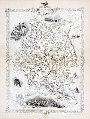
Independent Tartary [Antique Map]
Idioma: Inglés
Publicado por The London Printing and Publishing Company, London, 1855
Librería: Books & Bidders, Cleveland, OH, Estados Unidos de America
Miembro de asociación: IOBA
Calificación del vendedor: 5 de 5 estrellas
Mapa
EUR 27,01
Gastos de envío gratis
Se envía dentro de Estados Unidos de AmericaCantidad disponible: 1 disponibles
Ańadir al carritoNo Binding. Condición: Very Good. [Map]. Original steel engraved map with decorative boarder and vignettes. Map size with central vertical fold is approx. 11 x 14 inches. Antique map of "Independent Tartary" N.D. (no date, circa 1855). Vignettes of Tartars on a Journey, The Bride Chase, and The Tent. Map scale in British miles. Map drawn and engraved by J. Rapkin, with illustrations by W. Bragg and engraved by J. Rogers. Contemporary pen outlining in color. By 1865 Tallis was among the last of the publishers of beautifully decorated hand engraved maps. Shows some expected page toning and light wear at corners.
-

Map Of England & Wales With Original Outline Colour
Publicado por J & F. Tallis, London, 1851
Librería: Victoria Bookshop, BERE ALSTON, DEVON, Reino Unido
Calificación del vendedor: 3 de 5 estrellas

Original o primera edición
EUR 13,69
Envío por EUR 11,50
Se envía de Reino Unido a Estados Unidos de AmericaCantidad disponible: 1 disponibles
Ańadir al carritoPaperback. Condición: Fair. First Edition. The Map With Some Original Outline Colour And With Finely Engraved Decorative Vignette Views Drawn By N. Whitlock And Engraved By J. Rogers Including London, Oxford, Portsmouth Harbour, Doncaster Race Ground, Etc, All Contained Within Decorative Engraved Borders. The Map Also With Engraved Printed Title And Separate Scale Of Distance. Image Size Approx. 245mm X 330mm (9.5in X 13in) With Margins. A little foxed and thumbed. Scribble in pencil on rear. Small ink mark on sussex. Book.
-
FACSIMILE OF 19th CENTURY PLAN OF BRADFORD, WEST YORKSHIRE
Idioma: Inglés
Ańo de publicación: 1980
Librería: K Books Ltd ABA ILAB, York, YORKS, Reino Unido
Miembro de asociación: ABA ILAB PBFA
Calificación del vendedor: 5 de 5 estrellas
EUR 3,61
Envío por EUR 22,76
Se envía de Reino Unido a Estados Unidos de AmericaCantidad disponible: 1 disponibles
Ańadir al carritoNo Binding. Condición: Very Good. J Rapkin Ilustrador. Facsimile. Facsimile of a Plan of Bradford, West Yorkshire engraved by Rapkin, in a decorative border, inset with small engravings of Airedale College, St George's Hall, churches, the cemetery, the Infirmary and the Terminus of the Bradford and Halifax Railway. Printed on thin card. This will be posted rolled, in a tube.
-

The Premenstrual Syndromes PMS and PMDD
Idioma: Inglés
Publicado por Informa Healthcare, London, 2007
ISBN 10: 0415399742 ISBN 13: 9780415399746
Librería: Librakons Rare Books and Collectibles, Istanbul, Turquia
Calificación del vendedor: 5 de 5 estrellas
EUR 23,41
Envío por EUR 24,95
Se envía de Turquia a Estados Unidos de AmericaCantidad disponible: 1 disponibles
Ańadir al carritoHardcover. Condición: Fine. 197pp., 24x18cm., in English.
-
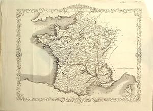
France and Corsica
Ańo de publicación: 1865
Librería: theoldmapman, Clevedon, SOMER, Reino Unido
Calificación del vendedor: 5 de 5 estrellas
Mapa
EUR 10,82
Envío por EUR 7,59
Se envía de Reino Unido a Estados Unidos de AmericaCantidad disponible: 1 disponibles
Ańadir al carritoSingle sheet. Uncoloured map with elaborate border. Original folds. 32 x 26 cm.
-
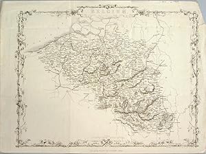
Belgium
Ańo de publicación: 1865
Librería: theoldmapman, Clevedon, SOMER, Reino Unido
Calificación del vendedor: 5 de 5 estrellas
Mapa
EUR 12,02
Envío por EUR 7,59
Se envía de Reino Unido a Estados Unidos de AmericaCantidad disponible: 1 disponibles
Ańadir al carritoSingle sheet. Uncoloured map with elaborate border. Original folds and a few creases and a few marginal repairs 34 x 26 cm.
-
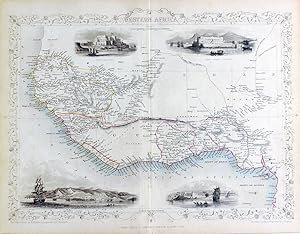
New Zealand [Antique Map]
Idioma: Inglés
Publicado por John Tallis, London, 1851
Librería: Books & Bidders, Cleveland, OH, Estados Unidos de America
Miembro de asociación: IOBA
Calificación del vendedor: 5 de 5 estrellas
Mapa
EUR 40,52
Gastos de envío gratis
Se envía dentro de Estados Unidos de AmericaCantidad disponible: 1 disponibles
Ańadir al carritoNo Binding. Condición: Good. [New Zealand Map]. Original steel engraved map with decorative boarder and vignettes. Map size with central vertical fold is 14 x 11 inches. Antique map of "New Zealand" by John Tallis & Company, circa 1851. Vignettes of Auckland, Mount Egmont from New Plymouth, Wellington, and Indigenous person. Map drawn and engraved by John Rapkin, with illustrations by H. Warren and engraved by J.B. Allen. Contemporary pen outlining in color and pale blue coastline wash. By 1865 Tallis was among the last of the publishers of beautifully decorated hand engraved maps. Trimmed at top and bottom, with some light expected page toning.
-
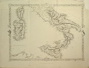
Southern Italy
Ańo de publicación: 1865
Librería: theoldmapman, Clevedon, SOMER, Reino Unido
Calificación del vendedor: 5 de 5 estrellas
Mapa
EUR 15,63
Envío por EUR 7,59
Se envía de Reino Unido a Estados Unidos de AmericaCantidad disponible: 1 disponibles
Ańadir al carritoSingle sheet. Uncoloured map south of the Papal States with Sicily, Corsica and Sardinia with elaborate border including figures. Just one railway line from Capua to Nola, a distance of 24 miles. Original folds. Very nice condition. 32 x 24 cm.
-
Holland, antique map with vignette views
Publicado por John Tallis & Co., London, 1854
Librería: Antipodean Books, Maps & Prints, ABAA, Garrison, NY, Estados Unidos de America
Miembro de asociación: ABAA ANZAAB ESA ILAB
Calificación del vendedor: 4 de 5 estrellas

EUR 25,21
Envío por EUR 8,74
Se envía dentro de Estados Unidos de AmericaCantidad disponible: 1 disponibles
Ańadir al carritoMaps. Steel engraved map from the famous Victorian publisher John Tallis, well-known for the attractive vignette views surrounding the maps, which illustrate the peoples & customs of the region. 9 3/4 x 13 1/2" plus margins. Attractive decorative border around edge, very good condition.
-
Turkey in Europe, antique map with vignette views
Publicado por John Tallis & Co., London, 1854
Librería: Antipodean Books, Maps & Prints, ABAA, Garrison, NY, Estados Unidos de America
Miembro de asociación: ABAA ANZAAB ESA ILAB
Calificación del vendedor: 4 de 5 estrellas
EUR 25,21
Envío por EUR 8,74
Se envía dentro de Estados Unidos de AmericaCantidad disponible: 1 disponibles
Ańadir al carritoMaps. Steel engraved map from the famous Victorian publisher John Tallis, well-known for the attractive vignette views surrounding the maps, which illustrate the peoples & customs of the region. 12 1/2 x 10" plus margins. Attractive decorative border around edge, period outline color, very good condition.
-
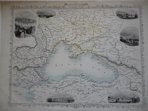
Black Sea
Idioma: Inglés
Publicado por London Printing and Publishing Co., (London)
Librería: Roger Collicott Books, Widecombe in the Moor, DEVON, Reino Unido
Calificación del vendedor: 5 de 5 estrellas
Mapa
EUR 42,08
Envío por EUR 36,95
Se envía de Reino Unido a Estados Unidos de AmericaCantidad disponible: 1 disponibles
Ańadir al carritoMap. Condición: Very Good. Attractive map with minimal original hand colouring with six small vignette views surrounding the map and decorative borders. With light vertical crease marks. Size : 315 x 235 mm.
-
MAP OF EUROPE
Publicado por THE LONDON PRINTING & PUBLISHING COMPANY, CIRCA 1851, 1851
Librería: Elder Books, Ross on Wye, Herefordshire, Reino Unido
Calificación del vendedor: 5 de 5 estrellas
Mapa
EUR 24,05
Envío por EUR 13,95
Se envía de Reino Unido a Estados Unidos de AmericaCantidad disponible: 1 disponibles
Ańadir al carritoNo Binding. Condición: Very Good. AN ORIGINAL MID 19th CENTURY MAP WITH DECORATIVE DESIGN TO BORDER, MEASURES APPROX 14 X 11 INCHES WITH MARGINS, BLANK REVERSE TO MAP. SEVERAL FOLDS TO MAP AS PUBLISHED, MINOR TRIMMING TO RIGHT SIDE OF MARGIN WHICH WILL BE COVERED ONCE FRAMED & MOUNTED, FEW VERY LIGHT MARKS & MINOR CREASES TO MARGINS. OVERALL IN VERY GOOD CONDITION. EXTRA POSTAGE COSTS MAY APPLY TO OVERSEAS ORDERS. ALL ITEMS POSTED IN STURDY BOX/TUBE.
-
1851 Map of Peru and Bolivia with Engravings
Publicado por J & F Tallis, London, 1851
Librería: Turtle Creek Books and Sheet Music, Mississauga, ON, Canada
Calificación del vendedor: 5 de 5 estrellas
EUR 40,52
Envío por EUR 9,62
Se envía de Canada a Estados Unidos de AmericaCantidad disponible: 1 disponibles
Ańadir al carritoSoft cover. Condición: Good. Rapkin, J ; Winkles, H ; Kernot Ilustrador. Original 1851 map published by J & F Tallis of London. Gorgeous engravings by J Ripkin, illustratrations by Winkles and Kernot, map drawn and engraved by J. Rapkin. Hand coloured outlines, decorative borders, beautiful engraved vignettes within border edges. This rare map will be exceedingly handsome when properly mounted and framed. Overall dimensions are 14-1/2" x 10-1/2". Bottom edge slightly frayed however this should be addressed once mounted. Cited in Tooley's Dictionary of Maps. Slight age-toning, but still remarkably clean and bright. Bottom right hand corner has been tape repaired. Wonderful vignette illustrations of Potosi, Lima, Swimming Couriers or Peru, Tarija.
-
MAP OF GERMANY
Publicado por THE LONDON PRINTING & PUBLISHING COMPANY, CIRCA 1851, 1851
Librería: Elder Books, Ross on Wye, Herefordshire, Reino Unido
Calificación del vendedor: 5 de 5 estrellas
Arte / Grabado / Póster
EUR 24,05
Envío por EUR 13,95
Se envía de Reino Unido a Estados Unidos de AmericaCantidad disponible: 1 disponibles
Ańadir al carritoNo Binding. Condición: Very Good. AN ORIGINAL MID 19th CENTURY UNCOLOURED MAP WITH DECORATIVE DESIGN TO BORDER, MEASURES APPROX 15 X 11 INCHES WITH MARGINS, BLANK REVERSE TO MAP. SEVERAL FOLDS TO MAP AS PUBLISHED, MINOR WEAR TO MARGINS, FEW MINOR WRINKLES & VERY LIGHT MARKS TO MAP. OVERALL IN VERY GOOD CONDITION. EXTRA POSTAGE COSTS MAY APPLY TO OVERSEAS ORDERS. ALL ITEMS POSTED IN STURDY BOX.
-
Russia in Europe, antique map with vignette views
Publicado por John Tallis & Co., London, 1854
Librería: Antipodean Books, Maps & Prints, ABAA, Garrison, NY, Estados Unidos de America
Miembro de asociación: ABAA ANZAAB ESA ILAB
Calificación del vendedor: 4 de 5 estrellas
EUR 29,71
Envío por EUR 8,74
Se envía dentro de Estados Unidos de AmericaCantidad disponible: 1 disponibles
Ańadir al carritoMaps. Steel engraved map from the famous Victorian publisher John Tallis, well-known for the attractive vignette views surrounding the maps, which illustrate the peoples & customs of the region. 9 1/2 x 13 1/2" plus margins. Attractive decorative border around edge, period outline color, small archival repair at center, o/w very good condition.
-
Germany, antique map with vignette views
Publicado por John Tallis & Co., London, 1854
Librería: Antipodean Books, Maps & Prints, ABAA, Garrison, NY, Estados Unidos de America
Miembro de asociación: ABAA ANZAAB ESA ILAB
Calificación del vendedor: 4 de 5 estrellas
EUR 29,71
Envío por EUR 8,74
Se envía dentro de Estados Unidos de AmericaCantidad disponible: 1 disponibles
Ańadir al carritoMaps. Steel engraved map from the famous Victorian publisher John Tallis, well-known for the attractive vignette views surrounding the maps, which illustrate the peoples & customs of the region. 9 1/2 x 13 1/2" plus margins. Attractive decorative border around edge, period outline color, very good condition.
-
Belgium, antique map with vignette views
Publicado por John Tallis & Co., London, 1854
Librería: Antipodean Books, Maps & Prints, ABAA, Garrison, NY, Estados Unidos de America
Miembro de asociación: ABAA ANZAAB ESA ILAB
Calificación del vendedor: 4 de 5 estrellas
EUR 29,71
Envío por EUR 8,74
Se envía dentro de Estados Unidos de AmericaCantidad disponible: 1 disponibles
Ańadir al carritoMaps. Steel engraved map from the famous Victorian publisher John Tallis, well-known for the attractive vignette views surrounding the maps, which illustrate the peoples & customs of the region. 12 1/2 x 10" plus margins. Attractive decorative border around edge, original hand color. Very good condition.
-
British Guayana, antique map with vignette views
Publicado por John Tallis & Co., London, 1854
Librería: Antipodean Books, Maps & Prints, ABAA, Garrison, NY, Estados Unidos de America
Miembro de asociación: ABAA ANZAAB ESA ILAB
Calificación del vendedor: 4 de 5 estrellas
EUR 29,71
Envío por EUR 8,74
Se envía dentro de Estados Unidos de AmericaCantidad disponible: 1 disponibles
Ańadir al carritoMaps. Steel engraved map from the famous Victorian publisher John Tallis, well-known for the attractive vignette views surrounding the maps, which illustrate the peoples & customs of the region. Vignettes include: Georgetown, Christmas Cataract, New Amsterdam, and Ataraipu or the Devil's Rock. 10 x 12 1/2" plus margins. Attractive decorative border around edge, period outline color, very good condition.
-
Belgium, antique map with vignette views
Publicado por John Tallis & Co., London, 1854
Librería: Antipodean Books, Maps & Prints, ABAA, Garrison, NY, Estados Unidos de America
Miembro de asociación: ABAA ANZAAB ESA ILAB
Calificación del vendedor: 4 de 5 estrellas
EUR 29,71
Envío por EUR 8,74
Se envía dentro de Estados Unidos de AmericaCantidad disponible: 1 disponibles
Ańadir al carritoMaps. Steel engraved map from the famous Victorian publisher John Tallis, well-known for the attractive vignette views surrounding the maps, which illustrate the peoples & customs of the region. 12 1/2 x 10" plus margins. Attractive decorative border around edge, original hand color. Very good condition.
-
Russia in Europe, antique map with vignette views
Publicado por John Tallis & Co., London, 1854
Librería: Antipodean Books, Maps & Prints, ABAA, Garrison, NY, Estados Unidos de America
Miembro de asociación: ABAA ANZAAB ESA ILAB
Calificación del vendedor: 4 de 5 estrellas
EUR 29,71
Envío por EUR 8,74
Se envía dentro de Estados Unidos de AmericaCantidad disponible: 1 disponibles
Ańadir al carritoMaps. Steel engraved map from the famous Victorian publisher John Tallis, well-known for the attractive vignette views surrounding the maps, which illustrate the peoples & customs of the region. 9 1/2 x 13 1/2" plus margins. Attractive decorative border around edge, period outline color, very good condition.
-
Western Africa, antique map with vignette views
Publicado por John Tallis & Co., London, 1854
Librería: Antipodean Books, Maps & Prints, ABAA, Garrison, NY, Estados Unidos de America
Miembro de asociación: ABAA ANZAAB ESA ILAB
Calificación del vendedor: 4 de 5 estrellas
EUR 29,71
Envío por EUR 8,74
Se envía dentro de Estados Unidos de AmericaCantidad disponible: 1 disponibles
Ańadir al carritoMaps. Steel engraved map from the famous Victorian publisher John Tallis, well-known for the attractive vignette views surrounding the maps, which illustrate the peoples & customs of the region. 12 1/2 x 10" plus margins. Attractive decorative border around edge, period outline color, very good condition.
-

West India Islands - West Indies - c.1865 Antique Engraving
Publicado por London Printing, UK, 1865
Librería: Maynard & Bradley, Leicester, Reino Unido
Calificación del vendedor: 5 de 5 estrellas
EUR 26,39
Envío por EUR 25,62
Se envía de Reino Unido a Estados Unidos de AmericaCantidad disponible: 1 disponibles
Ańadir al carritoSoftcover. Condición: Very Good. c.1865. A lightly used but well-presented map, with a few very faint spots of foxing but no major marks or wear. Some visible fold lines as originally presented, but neatly flattened to a good, presentable standard. Why on Amazon do most sellers not describe their actual book? Buy with confidence and support a genuine Independent Bricks & Mortar Real Bookshop. We are Maynard & Bradley CAMBO & PBFA(now lapsed) members here in Leicester City Centre. Size: 355 x 275 mm. 1. Item Type: Book. Quantity Available: 1. Shipped Weight: Under 500 grams. Category: Geography & Maps; Britain/UK; 19th century; Inventory No: 47469.
-

Regional Map of Germany - c.1865 Antique Engraving
Publicado por London Printing, UK, 1865
Librería: Maynard & Bradley, Leicester, Reino Unido
Calificación del vendedor: 5 de 5 estrellas
EUR 26,39
Envío por EUR 25,62
Se envía de Reino Unido a Estados Unidos de AmericaCantidad disponible: 1 disponibles
Ańadir al carritoSoftcover. Condición: Very Good. c.1865. A lightly used but well-presented map, with a few very faint spots of foxing but no major marks or wear. Some visible fold lines as originally presented, and some repair with conservation tape at the upper right corner, but neatly flattened to a good, presentable standard. Why on Amazon do most sellers not describe their actual book? Buy with confidence and support a genuine Independent Bricks & Mortar Real Bookshop. We are Maynard & Bradley CAMBO & PBFA(now lapsed) members here in Leicester City Centre. Size: 265 x 360 mm. 1. Item Type: Book. Quantity Available: 1. Shipped Weight: Under 500 grams. Category: Geography & Maps; Britain/UK; 19th century; Inventory No: 47476.
-

Regional Map of British Guyana - c.1865 Antique Engraving
Publicado por London Printing, UK, 1865
Librería: Maynard & Bradley, Leicester, Reino Unido
Calificación del vendedor: 5 de 5 estrellas
EUR 26,39
Envío por EUR 25,62
Se envía de Reino Unido a Estados Unidos de AmericaCantidad disponible: 1 disponibles
Ańadir al carritoSoftcover. Condición: Very Good. c.1865. A lightly used but well-presented map, with a few very faint spots of foxing but no major marks or wear. Some visible fold lines as originally presented, but neatly flattened to a good, presentable standard. Why on Amazon do most sellers not describe their actual book? Buy with confidence and support a genuine Independent Bricks & Mortar Real Bookshop. We are Maynard & Bradley CAMBO & PBFA(now lapsed) members here in Leicester City Centre. Size: 355 x 275 mm. 1. Item Type: Book. Quantity Available: 1. Shipped Weight: Under 500 grams. Category: Geography & Maps; Britain/UK; 19th century; Inventory No: 47470.
-

Cape Colony, Dutch & British Territory - c.1865 Antique Engraving
Publicado por London Printing, UK, 1865
Librería: Maynard & Bradley, Leicester, Reino Unido
Calificación del vendedor: 5 de 5 estrellas
EUR 26,39
Envío por EUR 25,62
Se envía de Reino Unido a Estados Unidos de AmericaCantidad disponible: 1 disponibles
Ańadir al carritoSoftcover. Condición: Very Good. c.1865. A lightly used but well-presented map, with a few very faint spots of foxing but no major marks or wear. Some visible fold lines as originally presented, and some repair with conservation tape at the lower left and upper right corners, but neatly flattened to a good, presentable standard. Why on Amazon do most sellers not describe their actual book? Buy with confidence and support a genuine Independent Bricks & Mortar Real Bookshop. We are Maynard & Bradley CAMBO & PBFA(now lapsed) members here in Leicester City Centre. Size: 335 x 270 mm. 1. Item Type: Book. Quantity Available: 1. Shipped Weight: Under 500 grams. Category: Geography & Maps; Britain/UK; 19th century; Inventory No: 47477.
-
The Battle of the Alma - Showing the English, French , Russian and Turkish Forces - an Original Antique Engraved Map
Idioma: Inglés
Ańo de publicación: 1860
Librería: K Books Ltd ABA ILAB, York, YORKS, Reino Unido
Miembro de asociación: ABA ILAB PBFA
Calificación del vendedor: 5 de 5 estrellas
EUR 24,05
Envío por EUR 22,76
Se envía de Reino Unido a Estados Unidos de AmericaCantidad disponible: 1 disponibles
Ańadir al carritoNo Binding. Condición: Very Good. Engraved By J. Rapkin Ilustrador. An original antique engraved map, printed circa 1860. Hand-colouring contemporary. Mounted and ready to frame. A fine opportunity to purchase an attractive and decorative map - The Battle of the Alma - Showing the English, French , Russian and Turkish Forces on the 19th and 20th September, 1854. Lovley decoratively engraved frame.
-
MODERN PALESTINE Steel engraved map
Idioma: Inglés
Publicado por John Tallis and Company, London, 1851
Librería: Don Kelly Books, London, Reino Unido
Calificación del vendedor: 3 de 5 estrellas
EUR 48,10
Envío por EUR 15,97
Se envía de Reino Unido a Estados Unidos de AmericaCantidad disponible: 1 disponibles
Ańadir al carritoNo Binding. Condición: Very Good. Rapkin J Ilustrador. Steel engraving of modern Palestine with original hand outline. Image measures 12.75" x 9.5". Includes historically and culturally relevant vignettes such as views of Jaffa and Nazareth, fauna and natives of Lebanon. John Tallis Jr. (1817-1876) was a London born bookseller who continued the prolific map publishing company started by his father. After a partnership with his brother, Tallis Jr. expanded the business to New York in 1849 as well as Boston, Cincinnati, Rochester, Philadelphia and Baltimore. He is remembered as one of the last decorative map makers, and this lovely map exemplifies his work. Less.
![Imagen del vendedor de Independent Tartary [Antique Map] a la venta por Books & Bidders](https://pictures.abebooks.com/inventory/md/md31800635682.jpg)

![Imagen del vendedor de New Zealand [Antique Map] a la venta por Books & Bidders](https://pictures.abebooks.com/inventory/md/md31800637588.jpg)

