Hogenberg (Más de 1800 resultados)

Editorial: Boghallen
Librería: Wonder Book, Frederick, MD, Estados Unidos de AmericaWonder Book
Contactar con el vendedorVendedor de 5 estrellasCondición: Usado - Bueno
EUR 10,19
Gastos de envío gratisSe envía dentro de Estados Unidos de AmericaCantidad disponible: 1 disponibles
Añadir al carritoCondición: Very Good. Very Good condition. Good dust jacket. Danish edition. (old illustrations european cities).
Idioma: Alemán
Editorial: Bertelsmann, Gütersloh, 1965
- Tapa dura
Librería: 3 Mile Island, Grafenwöhr, Alemania3 Mile Island
Contactar con el vendedorVendedor de 4 estrellasCondición: Usado - Excelente
EUR 3,00
Envío por EUR 9,95Se envía de Alemania a Estados Unidos de AmericaCantidad disponible: 1 disponibles
Añadir al carritoHardcover. Condición: Sehr gut. Estado de la sobrecubierta: Sehr gut. Buchclub-Ausgabe. Pappband mit Schutzumschlag.
Librería: Kennys Bookstore, Olney, MD, Estados Unidos de AmericaKennys Bookstore
Contactar con el vendedorVendedor de 5 estrellasCondición: Nuevo
EUR 11,89
Envío por EUR 9,20Se envía dentro de Estados Unidos de AmericaCantidad disponible: 1 disponibles
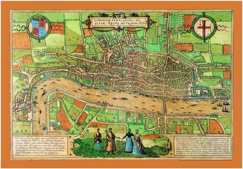
Condición: New. A map of the Elizabethan London. It offers an insight into the geography of the capital and lives of its inhabitants. It features the infamous Tower of London, a bear baiting arena, the Charterhouse monastery, the monument at Chary-ncros, Old St Paul's Cathedral and even local wildlife in the grassy fields north…of Holborn. Series: Old House. BIC Classification: 1DBKESL; 3JB; HBTP1. Category: (G) General (US: Trade). Dimension: 475 x 140 x 40. Weight in Grams: 46. New. 2012. Map. . . . . Books ship from the US and Ireland.

Editorial: Contentum Ltd., Larnaca, Cyprus
- Tapa dura
- Arte / Grabado / Póster
Librería: Contentum, Nicosia, ChipreContentum
Contactar con el vendedorVendedor de 5 estrellasCondición: Nuevo
EUR 17,99
Gastos de envío gratisSe envía de Chipre a Estados Unidos de AmericaCantidad disponible: Más de 20 disponibles
Añadir al carritoLoose Leaf. Condición: New. Reproduction. Original title: Angel with the veronica cloth by the cross German: Engel mit dem Veronica Tuch am Kreuz French: Ange avec le tissu veronica par la croix Spanish: Ángel con la tela verónica junto a la cruz High-quality fine-art reproduction based on an original work from the Rijksmuseum.…Creation period: 17th century (1608). Professionally printed on premium fine-art paper (Photo Matt Fibre) in size A5. The motif is printed with a white border (museum-style presentation). No.
Alte deutsche Städtebilder
Bruhn, W. / Oehme, R. ( Texte ) Braun, George / Hogenberg, Franz ( Bilder )
Editorial: J. Asmus Verlag 1964, 1968
Librería: Antiquariat Walter Nowak, göttingen, AlemaniaAntiquariat Walter Nowak
Contactar con el vendedorVendedor de 5 estrellasCondición: Usado
EUR 3,00
Envío por EUR 9,90Se envía de Alemania a Estados Unidos de AmericaCantidad disponible: 1 disponibles
Añadir al carritogeringe äußere Gebrauchsspuren. Gewicht in Gramm: 550.
Editorial: Leipzig, J.Asmus Verlag, 1938, 1938
Librería: Antiquariat Walter Nowak, göttingen, AlemaniaAntiquariat Walter Nowak
Contactar con el vendedorVendedor de 5 estrellasCondición: Usado
EUR 3,00
Envío por EUR 9,90Se envía de Alemania a Estados Unidos de AmericaCantidad disponible: 1 disponibles
Añadir al carrito24 farbige Blätter Gewicht in Gramm: 550 altersbedingte äußere Gebrauchsspuren, innen sauber.
Editorial: Thames and Hudson NULL
- Tapa dura
Librería: Anybook.com, Lincoln, Reino UnidoAnybook.com
Contactar con el vendedorVendedor de 5 estrellasCondición: Usado - Aceptable
EUR 3,04
Envío por EUR 16,00Se envía de Reino Unido a Estados Unidos de AmericaCantidad disponible: 1 disponibles
Añadir al carritoCondición: Good. This is an ex-library book and may have the usual library/used-book markings inside.This book has hardback covers. In good all round condition. No dust jacket. Please note the Image in this listing is a stock photo and may not match the covers of the actual item,400grams, ISBN.
Editorial: Farbiges Tauchnitz-Buch, 1954
- Tapa dura
Librería: The Story Shop, Elwood, IN, Estados Unidos de AmericaThe Story Shop
Contactar con el vendedorVendedor de 4 estrellasCondición: Usado - Bueno
EUR 14,37
Envío por EUR 5,21Se envía dentro de Estados Unidos de AmericaCantidad disponible: 1 disponibles
Añadir al carritoHardcover. Condición: Very Good. Very Good dust. Illustrated in color. ; Small 8vo 7½" - 8".
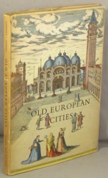
Old European Cities; Twenty-four 16th-Century City Maps and Texts .
Braun, Georg; Franz Hogenberg; Arthur Hibbert; Ruthardt Oehme
Idioma: Inglés
Editorial: Tauchnitz, 1955
- Tapa dura
Librería: Dogwood Books, Rome, GA, Estados Unidos de AmericaDogwood Books
Contactar con el vendedorVendedor de 5 estrellasCondición: Usado - Bueno
EUR 25,26
Envío por EUR 5,69Se envía dentro de Estados Unidos de AmericaCantidad disponible: 1 disponibles
Añadir al carritoHardcover. Condición: Very Good. No Jacket. The cover shows light wear. There is age toning inside the covers. No dustjacket.
Editorial: Johannes Asmus Verlag
Librería: Wonder Book, Frederick, MD, Estados Unidos de AmericaWonder Book
Contactar con el vendedorVendedor de 5 estrellasCondición: Usado - Regular
EUR 14,91
Gastos de envío gratisSe envía dentro de Estados Unidos de AmericaCantidad disponible: 1 disponibles
Añadir al carritoCondición: Fair. Acceptable condition. No Dust Jacket German. 'Old German Cityscapes'. Reading copy only. Lacking backstrip. Short gifter's inscription on front pastedown. (history, germany, maps).
Librería: Kennys Bookshop and Art Galleries Ltd., Galway, GY, IrlandaKennys Bookshop and Art Galleries Ltd.
Contactar con el vendedorVendedor de 5 estrellasCondición: Nuevo
EUR 13,36
Envío por EUR 10,50Se envía de Irlanda a Estados Unidos de AmericaCantidad disponible: 1 disponibles
Condición: New. A map of the Elizabethan London. It offers an insight into the geography of the capital and lives of its inhabitants. It features the infamous Tower of London, a bear baiting arena, the Charterhouse monastery, the monument at Chary-ncros, Old St Paul's Cathedral and even local wildlife in the grassy fields north…of Holborn. Series: Old House. BIC Classification: 1DBKESL; 3JB; HBTP1. Category: (G) General (US: Trade). Dimension: 475 x 140 x 40. Weight in Grams: 46. New. 2012. Map. . . . .

Idioma: Alemán
Editorial: Leipzig [C 1, Salomonstr. 25 B] : J. Asmus, 1938
Librería: books4less (Versandantiquariat Petra Gros GmbH & Co. KG), Welling, Alemaniabooks4less (Versandantiquariat Petra Gros GmbH & Co. KG)
Contactar con el vendedorVendedor de 5 estrellasCondición: Usado - Bueno
EUR 2,95
Envío por EUR 9,95Se envía de Alemania a Estados Unidos de AmericaCantidad disponible: 1 disponibles
Añadir al carritogebundene Ausgabe. Condición: Gut. 24 Bl. ; Das Buch ist ordentlich erhalten und kann altersbedingte Gebrauchsspuren aufweisen. Text in ALTDEUTSCHER SCHRIFT. Original-Schutzumschlag vorhanden (siehe Foto). Sprache: Deutsch Gewicht in Gramm: 305.
Editorial: Stuttgart, Johannes Asmus,, 1000
- Tapa blanda
Librería: Antiquariat Knacke, Berlin, AlemaniaAntiquariat Knacke
Contactar con el vendedorVendedor de 4 estrellasCondición: Usado
EUR 10,00
Envío por EUR 12,00Se envía de Alemania a Estados Unidos de AmericaCantidad disponible: 1 disponibles
Añadir al carritoSprache: Deutsch 11 lose farbige Blätter Mappe, etwas lichtrandig u. 16 Seiten Broschur. Guter Zustand.

- Tapa dura
Librería: medimops, Berlin, Alemaniamedimops
Contactar con el vendedorVendedor de 5 estrellasCondición: Usado - Bueno
EUR 24,18
Envío por EUR 10,00Se envía de Alemania a Estados Unidos de AmericaCantidad disponible: 1 disponibles
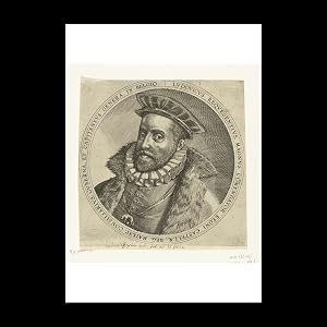
Condición: very good. Gut/Very good: Buch bzw. Schutzumschlag mit wenigen Gebrauchsspuren an Einband, Schutzumschlag oder Seiten. / Describes a book or dust jacket that does show some signs of wear on either the binding, dust jacket or pages. Hogenberg, Franz (ilustrador).
Editorial: Gebers, 1955
- Tapa dura
Librería: antikvariat sacher, Malmö, SKÅNE, Sueciaantikvariat sacher
Contactar con el vendedorVendedor de 4 estrellasCondición: Usado - Excelente
EUR 9,31
Envío por EUR 14,50Se envía de Suecia a Estados Unidos de AmericaCantidad disponible: 1 disponibles
Añadir al carritoimo. Condición: Fine.
 Más imágenes
Old European Cities; Twenty-four 16th-Century City Maps and Texts .
Braun, Georg; Franz Hogenberg; Arthur Hibbert; Ruthardt Oehme
Idioma: Inglés
Editorial: London, Thames & Hudson, no date.
- Tapa dura
Librería: Bucks County Bookshop IOBA, Doylestown, PA, Estados Unidos de AmericaBucks County Bookshop IOBA
Contactar con el vendedorVendedor de 5 estrellasMiembro de asociación: IOBA
Condición: Usado
EUR 31,58
Envío por EUR 5,21Se envía dentro de Estados Unidos de AmericaCantidad disponible: 1 disponibles
Añadir al carritoFrom the Civitates Orbis Terrarum of Georg Braun and Franz Hogenberg, with an interpretation by Arthur Hibbert, and a description by Ruthardt Oehme of early map-making techniques. -- Hardcover. Condition: near fine (endsheets lightly tanned) with bright, near fine dust jacket (flaps clipped; couple short tears; edges lightly rub…bed).

Editorial: Contentum Ltd., Larnaca, Cyprus
- Arte / Grabado / Póster
Librería: Contentum, Nicosia, ChipreContentum
Contactar con el vendedorVendedor de 5 estrellasCondición: Nuevo
EUR 17,99
Gastos de envío gratisSe envía de Chipre a Estados Unidos de AmericaCantidad disponible: Más de 20 disponibles
Añadir al carritoLoose Leaf. Condición: New. Reproduction. Original title: Fair of Hoboken German: Messe von Hoboken French: Foire de Hoboken Spanish: Feria de Hoboken High-quality fine-art reproduction based on an original work from the Rijksmuseum. Creation period: 16th century (1559). Professionally printed on premium fine-art paper (Photo Ma…tt Fibre) in size A5. The motif is printed with a white border (museum-style presentation). No.

Editorial: Contentum Ltd., Larnaca, Cyprus
- Arte / Grabado / Póster
Librería: Contentum, Nicosia, ChipreContentum
Contactar con el vendedorVendedor de 5 estrellasCondición: Nuevo
EUR 17,99
Gastos de envío gratisSe envía de Chipre a Estados Unidos de AmericaCantidad disponible: Más de 20 disponibles
Añadir al carritoLoose Leaf. Condición: New. Reproduction. Original title: Holy family German: Heilige Familie French: Sainte famille Spanish: Sagrada familia High-quality fine-art reproduction based on an original work from the Rijksmuseum. Creation period: 16th century (1540). Professionally printed on premium fine-art paper (Photo Matt Fibre)… in size A5. The motif is printed with a white border (museum-style presentation). No.

Editorial: Contentum Ltd., Larnaca, Cyprus
- Arte / Grabado / Póster
Librería: Contentum, Nicosia, ChipreContentum
Contactar con el vendedorVendedor de 5 estrellasCondición: Nuevo
EUR 17,99
Gastos de envío gratisSe envía de Chipre a Estados Unidos de AmericaCantidad disponible: Más de 20 disponibles
Añadir al carritoLoose Leaf. Condición: New. Reproduction. Original title: Narrendan German: Narrendan French: Narrendan Spanish: Narrendan High-quality fine-art reproduction based on an original work from the Rijksmuseum. Creation period: 16th century (1560). Professionally printed on premium fine-art paper (Photo Matt Fibre) in size A5. The mo…tif is printed with a white border (museum-style presentation). No.

Editorial: Contentum Ltd., Larnaca, Cyprus
- Arte / Grabado / Póster
Librería: Contentum, Nicosia, ChipreContentum
Contactar con el vendedorVendedor de 5 estrellasCondición: Nuevo
EUR 17,99
Gastos de envío gratisSe envía de Chipre a Estados Unidos de AmericaCantidad disponible: Más de 20 disponibles
Añadir al carritoLoose Leaf. Condición: New. Reproduction. Original title: Portrait of Henry III, King of France German: Porträt von Heinrich III., König von Frankreich French: Portrait d'Henri III, roi de France Spanish: Retrato de Enrique III, Rey de Francia High-quality fine-art reproduction based on an original work from the Rijksmuseum. Cre…ation period: 16th century (1585). Professionally printed on premium fine-art paper (Photo Matt Fibre) in size A5. The motif is printed with a white border (museum-style presentation). No.
Editorial: Contentum Ltd., Larnaca, Cyprus
- Arte / Grabado / Póster
Librería: Contentum, Nicosia, ChipreContentum
Contactar con el vendedorVendedor de 5 estrellasCondición: Nuevo
EUR 17,99
Gastos de envío gratisSe envía de Chipre a Estados Unidos de AmericaCantidad disponible: Más de 20 disponibles
Añadir al carritoLoose Leaf. Condición: New. Reproduction. Original title: Portrait of Luis de Requesens German: Porträt von Luis de Requesens French: Portrait de Luis de Requesens Spanish: Retrato de Luis de Requesens High-quality fine-art reproduction based on an original work from the Rijksmuseum. Creation period: 16th century (1573). Profess…ionally printed on premium fine-art paper (Photo Matt Fibre) in size A5. The motif is printed with a white border (museum-style presentation). No.

Editorial: Contentum Ltd., Larnaca, Cyprus
- Arte / Grabado / Póster
Librería: Contentum, Nicosia, ChipreContentum
Contactar con el vendedorVendedor de 5 estrellasCondición: Nuevo
EUR 17,99
Gastos de envío gratisSe envía de Chipre a Estados Unidos de AmericaCantidad disponible: Más de 20 disponibles
Añadir al carritoLoose Leaf. Condición: New. Reproduction. Original title: Map of the city of Utrecht German: Karte der Stadt Utrecht French: Carte de la ville de Utrecht Spanish: Mapa de la ciudad de Utrecht High-quality fine-art reproduction based on an original work from the Rijksmuseum. Creation period: 16th century (1572). Professionally pr…inted on premium fine-art paper (Photo Matt Fibre) in size A5. The motif is printed with a white border (museum-style presentation). No.

Editorial: Contentum Ltd., Larnaca, Cyprus
- Arte / Grabado / Póster
Librería: Contentum, Nicosia, ChipreContentum
Contactar con el vendedorVendedor de 5 estrellasCondición: Nuevo
EUR 17,99
Gastos de envío gratisSe envía de Chipre a Estados Unidos de AmericaCantidad disponible: Más de 20 disponibles
Añadir al carritoLoose Leaf. Condición: New. Reproduction. Original title: Cityscape of Groningen German: Stadtbild von Groningen French: Paysage urbain de Groningen Spanish: Paisaje urbano de Groningen High-quality fine-art reproduction based on an original work from the Rijksmuseum. Creation period: 16th century (1572). Professionally printed…on premium fine-art paper (Photo Matt Fibre) in size A5. The motif is printed with a white border (museum-style presentation). No.

Editorial: Contentum Ltd., Larnaca, Cyprus
- Arte / Grabado / Póster
Librería: Contentum, Nicosia, ChipreContentum
Contactar con el vendedorVendedor de 5 estrellasCondición: Nuevo
EUR 17,99
Gastos de envío gratisSe envía de Chipre a Estados Unidos de AmericaCantidad disponible: Más de 20 disponibles
Añadir al carritoLoose Leaf. Condición: New. Reproduction. Original title: Map of Amsterdam German: Karte von Amsterdam French: Carte de Amsterdam Spanish: Mapa de Ámsterdam High-quality fine-art reproduction based on an original work from the Rijksmuseum. Creation period: 16th century (1572). Professionally printed on premium fine-art paper (Ph…oto Matt Fibre) in size A5. The motif is printed with a white border (museum-style presentation). No.

Editorial: Contentum Ltd., Larnaca, Cyprus
- Arte / Grabado / Póster
Librería: Contentum, Nicosia, ChipreContentum
Contactar con el vendedorVendedor de 5 estrellasCondición: Nuevo
EUR 17,99
Gastos de envío gratisSe envía de Chipre a Estados Unidos de AmericaCantidad disponible: Más de 20 disponibles
Añadir al carritoLoose Leaf. Condición: New. Reproduction. Original title: Fort Rammekens taken, 1573 German: Fort Rammekens genommen, 1573 French: Fort Rammekens pris, 1573 Spanish: Fuerte Rammekens tomado, 1573 High-quality fine-art reproduction based on an original work from the Rijksmuseum. Creation period: 16th century (1573). Professionall…y printed on premium fine-art paper (Photo Matt Fibre) in size A5. The motif is printed with a white border (museum-style presentation). No.

Editorial: Contentum Ltd., Larnaca, Cyprus
- Arte / Grabado / Póster
Librería: Contentum, Nicosia, ChipreContentum
Contactar con el vendedorVendedor de 5 estrellasCondición: Nuevo
EUR 17,99
Gastos de envío gratisSe envía de Chipre a Estados Unidos de AmericaCantidad disponible: Más de 20 disponibles
Añadir al carritoLoose Leaf. Condición: New. Reproduction. Original title: Map of Zeeland German: Karte von Zeeland French: Carte de Zeeland Spanish: Mapa de Zelanda High-quality fine-art reproduction based on an original work from the Rijksmuseum. Creation period: 16th century (1579). Professionally printed on premium fine-art paper (Photo Matt… Fibre) in size A5. The motif is printed with a white border (museum-style presentation). No.

Editorial: Contentum Ltd., Larnaca, Cyprus
- Arte / Grabado / Póster
Librería: Contentum, Nicosia, ChipreContentum
Contactar con el vendedorVendedor de 5 estrellasCondición: Nuevo
EUR 17,99
Gastos de envío gratisSe envía de Chipre a Estados Unidos de AmericaCantidad disponible: Más de 20 disponibles
Añadir al carritoLoose Leaf. Condición: New. Reproduction. Original title: Map of Zeeland German: Karte von Zeeland French: Carte de Zeeland Spanish: Mapa de Zelanda High-quality fine-art reproduction based on an original work from the Rijksmuseum. Creation period: 16th century (1570). Professionally printed on premium fine-art paper (Photo Matt… Fibre) in size A5. The motif is printed with a white border (museum-style presentation). No.

Editorial: Contentum Ltd., Larnaca, Cyprus
- Arte / Grabado / Póster
Librería: Contentum, Nicosia, ChipreContentum
Contactar con el vendedorVendedor de 5 estrellasCondición: Nuevo
EUR 17,99
Gastos de envío gratisSe envía de Chipre a Estados Unidos de AmericaCantidad disponible: Más de 20 disponibles
Añadir al carritoLoose Leaf. Condición: New. Reproduction. Original title: Map of the island Voorne and map of Brielle, 1572 German: Karte der Insel Voorne und Karte von Brielle, 1572 French: Carte de l'île de Voorne et carte de Brielle, 1572 Spanish: Mapa de la isla Voorne y mapa de Brielle, 1572 High-quality fine-art reproduction based on an o…riginal work from the Rijksmuseum. Creation period: 16th century (1575). Professionally printed on premium fine-art paper (Photo Matt Fibre) in size A5. The motif is printed with a white border (museum-style presentation). No.

Editorial: Contentum Ltd., Larnaca, Cyprus
- Arte / Grabado / Póster
Librería: Contentum, Nicosia, ChipreContentum
Contactar con el vendedorVendedor de 5 estrellasCondición: Nuevo
EUR 17,99
Gastos de envío gratisSe envía de Chipre a Estados Unidos de AmericaCantidad disponible: Más de 20 disponibles
Añadir al carritoLoose Leaf. Condición: New. Reproduction. Original title: Landscape with duck and iris German: Landschaft mit Ente und Iris French: Paysage avec canard et iris Spanish: Paisaje con pato e iris High-quality fine-art reproduction based on an original work from the Rijksmuseum. Creation period: 17th century (1600). Professionally p…rinted on premium fine-art paper (Photo Matt Fibre) in size A5. The motif is printed with a white border (museum-style presentation). No.

Editorial: Contentum Ltd., Larnaca, Cyprus
- Arte / Grabado / Póster
Librería: Contentum, Nicosia, ChipreContentum
Contactar con el vendedorVendedor de 5 estrellasCondición: Nuevo
EUR 17,99
Gastos de envío gratisSe envía de Chipre a Estados Unidos de AmericaCantidad disponible: Más de 20 disponibles
Añadir al carritoLoose Leaf. Condición: New. Reproduction. Original title: Landscape with rose, leopard and plum tree German: Landschaft mit Rose, Leopard und Pflaumenbaum French: Paysage avec rose, léopard et prunier Spanish: Paisaje con rosa, leopardo y ciruelo High-quality fine-art reproduction based on an original work from the Rijksmuseum.…Creation period: 17th century (1600). Professionally printed on premium fine-art paper (Photo Matt Fibre) in size A5. The motif is printed with a white border (museum-style presentation). No.


