
Importe total (1 artículo artículos):
Destino del pedido:

gerardus mercator (206 resultados)
Ir a los resultados principales
Filtros de búsqueda
Tipo de artículo
- Todos los tipos de productos
- Libros (141)
- Revistas y publicaciones (No hay ningún otro resultado que coincida con este filtro.)
- Cómics (No hay ningún otro resultado que coincida con este filtro.)
- Partituras (No hay ningún otro resultado que coincida con este filtro.)
- Arte, grabados y pósters (3)
- Fotografías (1)
- Mapas (60)
- Manuscritos y coleccionismo de papel (1)
Condición Más información
- Nuevo (17)
- Como nuevo, Excelente o Muy bueno (58)
- Bueno o Aceptable (6)
- Regular o Pobre (No hay ningún otro resultado que coincida con este filtro.)
- Tal como se indica (125)
Encuadernación
Más atributos
- Primera edición (14)
- Firmado (No hay ningún otro resultado que coincida con este filtro.)
- Sobrecubierta (1)
- Con imágenes (191)
- No impresión bajo demanda (195)
Idioma (4)
Gastos de envío gratis
Ubicación del vendedor
Valoración de los vendedores
-
![Imagen de archivo de MERCATOR; THE MAN WHO MAPPED THE PLANET. [Biography of Flemish cartographer Gerhard Mercator - Gerardus Mercator.] a la venta por David Hallinan, Bookseller](https://pictures.abebooks.com/isbn/9780297646655-es-300.jpg)
MERCATOR; THE MAN WHO MAPPED THE PLANET. [Biography of Flemish cartographer Gerhard Mercator - Gerardus Mercator.]
Idioma: Inglés
Publicado por London: Weidenfeld & Nicolson, September 2002., 2002
ISBN 10: 0297646656 ISBN 13: 9780297646655
Librería: David Hallinan, Bookseller, Columbus, MS, Estados Unidos de America
Calificación del vendedor: 5 de 5 estrellas

EUR 11,26
Envío por EUR 6,56
Se envía dentro de Estados Unidos de AmericaCantidad disponible: 1 disponibles
Ańadir al carritoBritish third printing. xiv, 348 pages. Hardcover: H 24cm x L 16cm. Dust jacket lightly rubbed with slight bumping at spine and flap heads. Blue boards, light bumping at board corners. Pages are bright and clean. Binding retains some crispness. A near fine copy in a very good+ copy. With two sections of plates on unpaged leaves, b/w illustrations amongst text, A Personal Note to the Reader, Epilogue, Notes, Chronology of Mercator's Principal Works, Select Bibliography, and Index. Publisher's summary: "Explores the life of Gerhard Mercator, who created the map and solved the dimensional riddle that plagued cosmographers for years, revealing a man who attended one of Europe's top universities but was persecuted by the Inquisition." ISBN 0297646656.
-

Map of the Duchy of Brabant, Gulik and Cleves, A5
Publicado por Contentum Ltd., Larnaca, Cyprus
Librería: Contentum, Nicosia, Chipre
Calificación del vendedor: 5 de 5 estrellas
Arte / Grabado / Póster
EUR 17,99
Gastos de envío gratis
Se envía de Chipre a Estados Unidos de AmericaCantidad disponible: Más de 20 disponibles
Ańadir al carritoLoose Leaf. Condición: New. Reproduction. Original title: Map of the Duchy of Brabant, Gulik and Cleves German: Karte des Herzogtums Brabant, Gulik und Cleves French: Carte du Duché de Brabant, Gulik et Clčves Spanish: Mapa del Ducado de Brabante, Gulik y Cleves High-quality fine-art reproduction based on an original work from the Rijksmuseum. Creation period: 17th century (1628). Professionally printed on premium fine-art paper (Photo Matt Fibre) in size A5. The motif is printed with a white border (museum-style presentation). No.
-

Map of the Duchy of Brabant, Gulik and Cleves, A5
Publicado por Contentum Ltd., Larnaca, Cyprus
Librería: Contentum, Nicosia, Chipre
Calificación del vendedor: 5 de 5 estrellas
Arte / Grabado / Póster
EUR 17,99
Gastos de envío gratis
Se envía de Chipre a Estados Unidos de AmericaCantidad disponible: Más de 20 disponibles
Ańadir al carritoLoose Leaf. Condición: New. Reproduction. Original title: Map of the Duchy of Brabant, Gulik and Cleves German: Karte des Herzogtums Brabant, Gulik und Cleves French: Carte du Duché de Brabant, Gulik et Clčves Spanish: Mapa del Ducado de Brabante, Gulik y Cleves High-quality fine-art reproduction based on an original work from the Rijksmuseum. Creation period: 16th century (1585). Professionally printed on premium fine-art paper (Photo Matt Fibre) in size A5. The motif is printed with a white border (museum-style presentation). No.
-

Map of the Duchy of Brabant, Gulik and Cleves, A5
Publicado por Contentum Ltd., Larnaca, Cyprus
Librería: Contentum, Nicosia, Chipre
Calificación del vendedor: 5 de 5 estrellas
Arte / Grabado / Póster
EUR 17,99
Gastos de envío gratis
Se envía de Chipre a Estados Unidos de AmericaCantidad disponible: Más de 20 disponibles
Ańadir al carritoLoose Leaf. Condición: New. Reproduction. Original title: Map of the Duchy of Brabant, Gulik and Cleves German: Karte des Herzogtums Brabant, Gulik und Cleves French: Carte du Duché de Brabant, Gulik et Clčves Spanish: Mapa del Ducado de Brabante, Gulik y Cleves High-quality fine-art reproduction based on an original work from the Rijksmuseum. Creation period: 17th century (1611). Professionally printed on premium fine-art paper (Photo Matt Fibre) in size A5. The motif is printed with a white border (museum-style presentation). No.
-

Atlas minor Gerardi Mercatoris ?? I. Hondio plurimis ?neis tabulis auctus et illustratus 1634
Librería: Books Puddle, New York, NY, Estados Unidos de America
Calificación del vendedor: 4 de 5 estrellas

EUR 44,44
Envío por EUR 3,49
Se envía dentro de Estados Unidos de AmericaCantidad disponible: 4 disponibles
Ańadir al carritoCondición: New. pp. 654.
-
Atlas minor Gerardi Mercatoris ?? I. Hondio plurimis ?neis tabulis auctus et illustratus 1634
Librería: Majestic Books, Hounslow, Reino Unido
Calificación del vendedor: 4 de 5 estrellas
EUR 43,87
Envío por EUR 7,59
Se envía de Reino Unido a Estados Unidos de AmericaCantidad disponible: 4 disponibles
Ańadir al carritoCondición: New. pp. 654.
-
Atlas minor Gerardi Mercatoris ?? I. Hondio plurimis ?neis tabulis auctus et illustratus 1634
Librería: Biblios, Frankfurt am main, HESSE, Alemania
Calificación del vendedor: 4 de 5 estrellas
EUR 44,81
Envío por EUR 9,95
Se envía de Alemania a Estados Unidos de AmericaCantidad disponible: 4 disponibles
Ańadir al carritoCondición: New. pp. 654.
-
Prospectus for modern reprint of Atlas Sive Cosmographicae Meditationes De Fabrica Mundi Et Fabricati Figura.This is the prospectus for a book, not the book itself.
Publicado por Brussels, Belgium: Editions Culture et Civilization, [1964]., 1964
Librería: Wittenborn Art Books, San Francisco, CA, Estados Unidos de America
Calificación del vendedor: 5 de 5 estrellas
Manuscrito
EUR 45,02
Envío por EUR 8,74
Se envía dentro de Estados Unidos de AmericaCantidad disponible: 1 disponibles
Ańadir al carritoCondición: Good. Folio. Two folded unbound sheets [8 pp.] Printed on laid paper. B&W Illustrations. Good with tears. Text in Latin & English. This is the prospectus for a book, not the book itself.
-
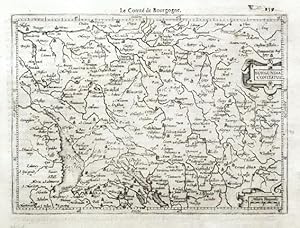
Burgundia Comitatus
Publicado por Hondius, Jodocus - Claesz., Cornelis and Jansz., Jan, Amsterdam, 1608
Librería: Antikvariat Krenek, Prag, Republica Checa
Miembro de asociación: ILAB
Calificación del vendedor: 5 de 5 estrellas
EUR 50,00
Envío por EUR 14,50
Se envía de Republica Checa a Estados Unidos de AmericaCantidad disponible: 1 disponibles
Ańadir al carrito"Burgundia Comitatus". Orig. copperplate engraving from G. Mercator's Atlas Minor. Published by J. Hondius, C. Claesz. and J. Jansz. in Amsterdam, 1608. With ornamental title-cartouche, another cartouche with the scale of map ("Milliaria Burgundiae") and French title ("Le Comte de Bourgogne") above the map. 13,5:18,5 cm (5 1/4 x 7 1/4 inch.). Koeman III, map 4880:351, ed. 351:11 (1608 Atlas Minor [Fr.]). - A miniature map of the eastern part of the French region of Bourgogne-Franche-Comte (BFC). Oriented to the West.
-
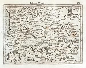
Artesia
Publicado por Hondius, Jodocus - Claesz., Cornelis and Jansz., Jan, Amsterdam, 1608
Librería: Antikvariat Krenek, Prag, Republica Checa
Miembro de asociación: ILAB
Calificación del vendedor: 5 de 5 estrellas
EUR 50,00
Envío por EUR 14,50
Se envía de Republica Checa a Estados Unidos de AmericaCantidad disponible: 1 disponibles
Ańadir al carrito"Artesia". Orig. copperplate engraving from G. Mercator's Atlas Minor. Published by J. Hondius, C. Claesz. and J. Jansz. in Amsterdam, 1608. With ornamental title-cartouche, another cartouche with the scale of map ("Miliaria Germanica") and French title ("Le Comte d'Artoys") above the map. 13,5:18 cm (5 1/4 x 7 inch.). Koeman III, map 330:351, ed. 351:11 (1608 Atlas Minor [Fr.]). - A miniature map of Artois, a region of northern France.
-

Mercator Atlas 1595
Publicado por Coron-Verlag, 1979
Librería: Recycle Bookstore, San Jose, CA, Estados Unidos de America
Calificación del vendedor: 4 de 5 estrellas
EUR 112,55
Envío por EUR 5,03
Se envía dentro de Estados Unidos de AmericaCantidad disponible: 1 disponibles
Ańadir al carritoHardcover. Condición: Very Good. Cover has one tiny bump to edge and a few very small faint smudges to rear, otherwise looks clean, bright, and attractive overall. Solid binding. Pages clean, bright, and crisp. Overall a sturdy and attractive copy. Due to size overseas shipping would be prohibitive.
-

Fessae et Marocchi Regna
Ańo de publicación: 1950
Librería: Quagga Books ABA ; ILAB, Cape Town, Sur Africa
Miembro de asociación: ABA ILAB
Calificación del vendedor: 5 de 5 estrellas
Mapa
EUR 23,77
Envío por EUR 30,00
Se envía de Sur Africa a Estados Unidos de AmericaCantidad disponible: 1 disponibles
Ańadir al carritoA 15th century map of the kingdoms of Fez and Morocco. Originally published c. 1620, this is a 20th century copy. Very good condition, sheet size: 66 x 52cm. Printed on good quality paper, with a central fold.
-

Atlas sive Cosmographicae Meditationes de Fabrica Mundi et Fabricati Figura.
Publicado por Fines Mundi, Saarbrücken, 2010
Librería: Antiquariat Clement, Bonn, Alemania
Calificación del vendedor: 4 de 5 estrellas
EUR 75,00
Envío por EUR 51,00
Se envía de Alemania a Estados Unidos de AmericaCantidad disponible: 1 disponibles
Ańadir al carritoHardcover Wie neu. Condición: 0. REPRINT, NACHDRUCK, FAKSIMILE der Originalausgabe, ursprünglich in Duisburg 1595 erschienen. Auflage 499 Exemplare, hier Nummer 68. Leineneinband, montierter Fronttitel, goldgeprägte Rückentitelei, Lesebändchen, TADELLOS. Alle Karten in Farbe. Zustand WIE NEU. +++ 31 x 46 cm, 2,5 kg. +++ Stichwörter: Geografie Kartenwerk Gewicht in Gramm: 2500.
-
Atlas sive cosmographicae meditationes de fabrica mundi et fabricati figura.
Publicado por Coron (ohne Jahr), Lachen am Zürichsee
Librería: terrahe.oswald, Gangkofen, Alemania
Miembro de asociación: ILAB VDA
Calificación del vendedor: 5 de 5 estrellas
EUR 100,00
Envío por EUR 27,00
Se envía de Alemania a Estados Unidos de AmericaCantidad disponible: 1 disponibles
Ańadir al carritoFolio. Mit 4 farbigen Titeln, 57 doppelblattgroßen farbigen Karten und zahlreichen, meist farbigen Textabbildungen. 31,(1) S. (Kommentar). Orig.-Lederband mit goldgeprägtem Deckeltitel und blindgeprägtem Deckelornament. Faksimiledruck des Mercator-Atlas nach der Ausgabe Duisburg 1595, exclusiv für die Freunde des Hauses Coron. - Schönes Exemplar.
-
ATLAS sive COSMOGRAPHICAE MEDITATIONES de FABRICA MUNDI ET FABRICATI FIGURA.
Publicado por Originalausgabe Duisburg 1595, unveränderter Faksimilereprint 2010., 1595
Librería: TINTENKILLER, Dortmund, NRW, Alemania
Calificación del vendedor: 4 de 5 estrellas
EUR 95,00
Envío por EUR 35,00
Se envía de Alemania a Estados Unidos de AmericaCantidad disponible: 1 disponibles
Ańadir al carritoLeineneinband mit Titelschild, Seiten nicht numeriert, 46x31 cm, 2418 gr. Numeriertes Exemplar (Nr. 083) des auf 499 Exemplare limitierten Nachdrucks, hergestellt von Fines Mundi Saarbrücken für die Buchversender Rhenania und Akzente. Sprache: deutsch. Gut erhaltenes Exemplar.
-

Holsatia
Publicado por Jodocus Hondius, Amsterdam, 1609
Librería: Antikvariat Krenek, Prag, Republica Checa
Miembro de asociación: ILAB
Calificación del vendedor: 5 de 5 estrellas
Mapa
EUR 62,51
Envío por EUR 14,50
Se envía de Republica Checa a Estados Unidos de AmericaCantidad disponible: 1 disponibles
Ańadir al carritoKein Einband. Condición: Sehr gut. Holstein. "Holsatia". Orig. Kupferstich Karte aus Mercators Atlas Minor. Bei J. Hondius in Amsterdam, 1609. Mit ornamt. Titelkart und fr. Titel ('Danemarck') über die Karte. 13,5:18,5 cm. Koeman III, map 1660:351, ed. 351:11 (1609 Atlas Minor [Fr.]). - Karte von Holstein mit Hamburg, Lübeck u. a.
-
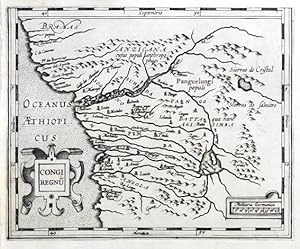
Congi Regnum
Publicado por Hondius, Jodocus, Amsterdam, 1607
Librería: Antikvariat Krenek, Prag, Republica Checa
Miembro de asociación: ILAB
Calificación del vendedor: 5 de 5 estrellas
EUR 62,51
Envío por EUR 14,50
Se envía de Republica Checa a Estados Unidos de AmericaCantidad disponible: 1 disponibles
Ańadir al carritoCongo (Western Africa). "Congi Regnum". Orig. copperplate engraving from G. Mercator's Atlas Minor. Published in Amsterdam by J. Hondius, C. Claesz. and J, Jansz., 1607. With ornamental title-cartouche and another ornamental cartouche with the scale of map. 14:17,5 cm (5 1/2 x 7 inch.). Norwich 319a; Koeman III, map 8755:351, ed. 351:01 (1607 Atlas Minor). - A decorative miniature map of the western part of Africa (today Gabon, Congo, Zaire, Angola) with depiction of Congo river basin.
-

Germania
Publicado por Hondius, Jodocus, 1609
Librería: Antikvariat Krenek, Prag, Republica Checa
Miembro de asociación: ILAB
Calificación del vendedor: 5 de 5 estrellas
Mapa
EUR 62,51
Envío por EUR 14,50
Se envía de Republica Checa a Estados Unidos de AmericaCantidad disponible: 1 disponibles
Ańadir al carritoKein Einband. Condición: Sehr gut. Mitteleuropa. "Germania". Orig. copperplate engraving from Mercator's Atlas Minor. Published by J. Hondius in Amsterdam, 1609. With ornamental title cartouche and title above the map ('La Germanie'). 15:19,5 cm on paper sized 17,5:22 cm. Koeman III, map 2000:351, ed. 351:11 (1609 Atlas Minor [Fr.]). - A miniature map of Central Europe.
-

Fessae et Marocchi Plan de Oran y de Sus Castellos y de Masalquivir
Ańo de publicación: 1950
Librería: Quagga Books ABA ; ILAB, Cape Town, Sur Africa
Miembro de asociación: ABA ILAB
Calificación del vendedor: 5 de 5 estrellas
Mapa
EUR 28,10
Envío por EUR 30,00
Se envía de Sur Africa a Estados Unidos de AmericaCantidad disponible: 1 disponibles
Ańadir al carritoCopy of a manuscript map of Oran and its castles, and of Mazalquivir, located in present-day Algeria. Likely produced in the 18th century, this is a 20th century copy. Very good condition, sheet size: 66 x 52cm. Printed on good quality paper, with a central fold.
-
400 Jahre Mercator-Atlas 1595-1995. Atlas sive Cosmographicae meditationes de fabrica mundi et fabricati figura.Num. Exemplar Nr.1243 einer Auflage von 1995 Exemplaren. o. J. um 1990
Publicado por Coron Verlag: o.J. um 1990, Lachen am Zürichsee., 1990
Librería: Buecherstube Eilert, Versandantiquariat, Dresden, DD, Alemania
Calificación del vendedor: 5 de 5 estrellas
EUR 260,00
Envío por EUR 48,00
Se envía de Alemania a Estados Unidos de AmericaCantidad disponible: 1 disponibles
Ańadir al carrito2° 45 x 33,5 cm mit 10 n.n. Blatt, 58 doppelblattgroßen farbigen Karten nebst Beschreibung sowie 31 Seiten Einführung in das Werk Mercators mit einigen Abbildungen und Illustrationen. Exemplar Nr.1243 .Gebunden in gold- und blindgeprägtem Ganzleder mit faksimiliertem Rückenschildchen, Goldschnitt, Messingbeschlägen und 2 Messing-Schließen,sehr guter Zustand, neuwertig in original Styropor-Verlagsbox. 25, Wg, neu Sprache: de.
-
Atlas sive Cosmographicae meditationes de fabrica mundi et fabricati figura. [Faksimile der Ausgabe von 1595.]
Publicado por Zürich, Coron, ,, 1980
Librería: Books & Art, Reichenbach, Alemania
Calificación del vendedor: 5 de 5 estrellas
EUR 150,00
Envío por EUR 200,00
Se envía de Alemania a Estados Unidos de AmericaCantidad disponible: 1 disponibles
Ańadir al carritoFolio, Leder-Einband im Schuber, Einband schwach berieben, sehr guter, sauberer Zustand. Sprache: Deutsch.
-
ATLAS SIVE COSMOGRAPHICAE MEDITATIONES DE FABRICA MUNDI ET FABRICA FIGURA
Publicado por ZURICH CORON, 2000
Librería: Hawkridge Books, Bakewell, Reino Unido
Calificación del vendedor: 4 de 5 estrellas
EUR 480,95
Envío por EUR 35,02
Se envía de Reino Unido a Estados Unidos de AmericaCantidad disponible: 1 disponibles
Ańadir al carritoFACSIMILIE EDITION OF THE 1595 ATLAS. NO DATE BUT CIRCA 2000. FOLIO (18 B13 INCHES), BOUND IN FULL LEATHER, GILT DECORATION TO FRONT BOARD, RAISED BANDS, FACSIMILIE LABEL. FULL COLOUR ILLUSTRATIONS, INCLUDING DOUBLE-PAGE MAPS. A FINE COPY. WEIGHS 4.2 Kg.
-
Atlas sive cosmographicae meditationes de fabrica mundi et fabrica figura. Iam tandem ad finem perductus, quamplurimis aeneis tabulis Hispaniae, Africae, Asiae & Americae auctus ac illustratus ŕ Judoco Hondio. Quibus etiam additae (praeter Mercatoris) dilucidae & accuratae omnium tabularum descriptiones novae, studio et opera Pet. Montani.
Publicado por Jodocus Hondius,, Amsterdam,, 1606
Librería: Antiquariaat FORUM BV, Houten, Holanda
Miembro de asociación: ILAB NVVA
Calificación del vendedor: 5 de 5 estrellas
Original o primera edición
EUR 125.000,00
Envío por EUR 25,00
Se envía de Holanda a Estados Unidos de AmericaCantidad disponible: 1 disponibles
Ańadir al carritoThe first edition of the famous Mercator-Hondius Atlas, which follows the arrangement of the complete Mercator atlas published by Gerard Mercator's son Rumold in 1595 as the Atlas sive cosmographicć meditationes de fabrica mundi et fabricati figura. Gerard Mercator (1512-1594) coined the term "atlas" and published parts of his work before passing away in 1594. Mercator is known mostly for his attempt to represent the spherical earth as accurately as possible on a flat sheet of paper, now called the Mercator projection.Around 1604, the Flemish engraver and cartographer Jodocus Hondius (1563-1612), together with the pioneering Amsterdam publisher and mapmaker Cornelis Claesz. (ca. 1551-1609), had obtained the copper plates of the Mercator atlas. They probably bought them directly from Gerard Mercator Jr., grandson of Gerard Mercator. Hondius and Claesz. planned a new edition of the Mercator's atlas, and to compete with rival Abraham Ortelius. Hondius expanded the atlas by combining Mercator's 107 original plates with 37 newly engraved maps from his Amsterdam workshop, and by adding a partly new text to the maps, written by Petrus Montanus (ca. 1560-ca. 1626), a Latin schoolmaster who helped Hondius on a regular basis with the translation, writing, and editing explanatory texts for several of Hondius' atlases. This resulted in the publication in 1606 of the present amazing, so-called Mercator-Hondius atlas, which soon became one of the most significant milestones in cartographic history, marking the first time a truly comprehensive world atlas was published under Gerard Mercator's name. While Mercator's original focus heavily favoured Europe, Hondius added highly detailed regional maps of Asia, Africa, and the Americas, successfully transforming it into a global masterwork. Many maps are showing the results of the latest discoveries. The Arctic map, for example, reflects a fascinating mix of myth and exploration, visualising the North Pole as a massive magnetic rock surrounded by a whirlpool, while updating the text to account for recent Dutch voyages around Spitsbergen. The atlas features also influential depictions of the New World, such as the maps of Florida, Carolina, Virginia, and New Spain (Mexico). Aesthetically speaking, Hondius brought the atlas to a unprecedented level by introducing beautifully executed water typography, formal calligraphy, and decorative borders that made Amsterdam the epicentre of 17th-century cartography. The atlas became so popular that already the next year a new edition had to be published, and by 1633 there were 6 Latin and 5 French editions of the Mercator-Hondius atlas. The engraved title page is printed from the old copper plate, but personifications of the continents are added. The preliminaries, except the dedications, are also copied and some verses on the new edition are added.Many maps more or less browned, some a bit soiled and stained (esp. pp, 99-102), small wormhole in the title page and following three leaves, very tightly (re-)bound, gold-tooling shows signs of wear. Some of the maps are misbound. Otherwise a magnificent copy of a remarkable atlas.l P. van der Krogt, Koeman's Atlantes Neerlandici. New ed., vol. 1, no. 1.101A (pp. 62-68): this copy is complete. Original gold- and blind-tooled calf, re-cased, the original leather pasted to the new boards. With a large blind-tooled centrepiece in a blind-tooled lozenge frame, within a blind-tooled rectangle frame, gold-tooled smaller and larger corner pieces and a gold-tooled floral frame along the edges of the boards, both boards show the same design. Further with the title lettered in gold on the spine, and red edges. With an engraved title page and 144 mostly double-page maps, each with a signature (E-7T) and with explanatory texts on the recto of the first and on the verso of the second fol. (the text pages on the rectos and versos of the maps are paginated 33-354). Pages: [16], 354, [12] pp. [+ 8 + 4 + 4 + 8 = 24 pp. for the indexes].
-
Cl. Ptolemaei Alexandrini, geographiae libri octo, recogniti iam et diligenter emendati cum tabilis geographicis ad mentem auctoris restitutis ac emendatis, per Gerardum Mercatorem, Illustriß. Ducis Cliuensis etc. Cosmographum BOUND WITH Italiae, Sclavoniae et Grćcić tabulae geographicae, Per Gerardum Mercatorem Illustrußimi Ducis Juliae, Cliuiae, &c. Cosmographum Duysburgi editć
Publicado por Gottfried von Kempen & Mercator, Cologne & Duisburg, 1584
Librería: Arader Books, New York, NY, Estados Unidos de America
Calificación del vendedor: 5 de 5 estrellas
Original o primera edición
EUR 58.525,17
Gastos de envío gratis
Se envía dentro de Estados Unidos de AmericaCantidad disponible: 1 disponibles
Ańadir al carritoHardcover. Condición: Very good. Second. MERCATOR'S PTOLEMAIC AND ITALIAN ATLAS IN BOARDS, WITH OUTSTANDING CONTEMPORARY COLOR. Geographia: Cologne: Gottfried von Kempen, 1584. Second edition. Italia: [Duisburg: Mercator, 1589.] First edition. Folio in 6s and 2s (15 1/2" x 10 1/2", 395mm x 268mm). [Full collation avaioable.] With two hand-colored engraved title-pages and 43 (Geographia: 26 of 28, Italia: 17 of 22) double-page hand-colored engraved maps integral with the text, Italia extra-illustrated with a double-page hand-colored engraved map "Europa ad magnae Europae Gerardi Mercatoris P. imitationem Rumoldi Mercatoris" (Duisberg, ca. 1595; the first state, without text verso). Bound in later (XVIIIc?) paste-paper-covered boards backed in vellum (re-backed, with the original back-strip laid down). Ink manuscript title to the front cover (ligatured): "librx eńrmi/ ~PTLs~" with the Trisagion (hymn) in Greek in four lines above. On the spine, the author, title and date in ink manuscript. All edges of the text-block speckled blue. Re-backed, with the original back-strip laid down. Rubbed and worn, with some soiling. Mild tanning, in some places moderate, with the odd spot of soiling or foxing. Lacking 2 maps in the Geographia and 5 maps in the Italia; extra-illustrated with a 1595 Rumold Mercator map of Europe. Pigment oxidation throughout, with resultant cracking at the spine of quire N (Africae Tabula IIII). Scattered peripheral tears. Worming to the lower margin of the first three and final three leaves, not affecting the text. The free edges of the final two leaves extended. A worn graphite gift inscription to the recto of the front free end-paper seemingly repeated in ink along the verso of the same leaf. Oval blind-stamp to a paster paper label at the head of the title-leaf, repeated in ink verso. Claudius Ptolemaeus (usually anglicized to Ptolemy) was a second-century philosopher living in Roman Alexandria in Egypt. No manuscripts his Geographike Hyphegesis (Geographical Guidance; in Latin this is usually rendered Geographicae enarrationis libri octo or "eight books of geographical explanation") survive from before the XIIIc, but some XIIIc examples survive with maps that bear some relation to those Ptolemy himself drew. It was crucial to explorers; Columbus expected to find the East Indies because of Ptolemy's calculations and assertions about longitude. As the world expanded beyond its ancient bounds, discoveries were integrated into the Ptolemaic maps, distinct with their trapezoidal frames. Gerardus Mercator (1512-1594) pioneered the projection that bears his name and established the recognizable modern world map. Called by Ortelius (to whom the Geographia is dedicated) the modern Ptolemy, he edited the text of the Geographia in 1576, and was able to "correct" maps -- i.e., to present a Ptolemaic rather than a modern conception of the three continents (Europe, Africa, Asia) -- to conform to the revised text. There is a particularly strong emphasis on the (ancient) mapping of Asia. The present example has unusually rich color, which has oxidized over the centuries to tan the cellulose of the paper, while keeping the vibrant oranges intact. Bound with the Geographia is the (eventual) fifth part of Mercator's Atlas -- the first book so-called (and meaning, roughly, "a book of maps published at the same size"), published in six parts from 1585 to 1595 -- published at Duisburg in 1589: Italy, "Sclavonia" (the lands of the (South) Slavs, i.e., modern Bosnia, Herzegovina, Croatia, Serbia, Slovenia etc.) and Greece. Although a "custom" combination of works, it's not uncommon to find individual parts of the eventual Atlas combined with Mercator's Ptolemy. It speaks, seemingly, to a particularly south-eastern European purchaser. Geographia: VD-16 P 5219; Italia: Van der Krogt/Koeman 1:002A.
-
400 Jahre Mercator-Atlas 1595-1995. Atlas sive Cosmographicae meditationes de fabrica mundi et fabricati figura.
Publicado por Coron, Lachen am Zürichsee
Librería: Antiquariat Friederichsen e. K., Hamburg, Alemania
Miembro de asociación: BOEV
Calificación del vendedor: 5 de 5 estrellas
EUR 600,00
Envío por EUR 60,00
Se envía de Alemania a Estados Unidos de AmericaCantidad disponible: 1 disponibles
Ańadir al carrito( Ohne Erscheinungsjahr - offenbar 1995 erschienen ) ( Nummeriertes Exemplar Nr. 048 / 333 ) einer Auflage von 333 nummerierten Exemplaren der Exclusiv-Edition ) Faksimile der Ausgabe Duisburg 1595 nach dem Exemplar der Fürstenbergischen Hofbibliothek Donaueschingen. Mit 10 n.n. Blättern, 58 doppelblattgroßen farbigen Karten nebst Beschreibung sowie 31 Seiten Einführung in das Werk Mercators mit einigen Abbildungen und Illustrationen. Gebunden in gold- und blindgeprägtem Original-Ganzleder mit faksimiliertem Rückenschildchen, Goldschnitt, Messingbeschlägen und 2 Messing-Schließen, Folio ( 45 x 34 cm ). Das auf dem Titelblatt des Atlanten erwähnte *Das Bild der Erde* liegt nicht bei. Der Einband ist gering berieben, insgesamt von guter und dekorativer Erhaltung. ( Gewicht 5500 Gramm ) ( Lagerort AZ, Regal oben ) ( Weitere Bilder auf Anfrage erhältlich ) Artikel 12966 /// (No publication year apparently published in 1995) (Numbered copy no. 048/333 of an edition of 333 numbered copies of the Exclusive Edition) Facsimile of the Duisburg 1595 edition after the copy in the Fürstenberg Court Library, Donaueschingen. With 10 unnumbered leaves, 58 double-page color maps with descriptions, and a 31-page introduction to Mercator's work with some illustrations. Bound in original full leather with gold and blind tooling, facsimile spine label, gilt edges, brass fittings, and two brass clasps, folio (45 x 34 cm). The *Image of the Earth* mentioned on the title page of the atlas is not included. The binding shows slight rubbing; overall, it is in good and decorative condition. (Weight 5500 grams) (Storage location AZ, top shelf) (Further images available upon request) Item 12966 /// (Sans date de publication apparemment publié en 1995) (Exemplaire numéroté 048/333 d'une édition de 333 exemplaires numérotés de l'Édition Exclusive) Fac-similé de l'édition de Duisbourg de 1595 d'aprčs l'exemplaire conservé ŕ la Bibliothčque de la Cour de Fürstenberg, ŕ Donaueschingen. Comprend 10 feuillets non numérotés, 58 cartes en couleurs sur double page avec descriptions et une introduction de 31 pages ŕ l'uvre de Mercator, illustrée de quelques dessins. Reliure plein cuir d'origine avec dorures et décor ŕ froid, étiquette de titre reproduite au dos, tranches dorées, ferrures en laiton et deux fermoirs en laiton, format in-folio (45 x 34 cm). L'*Image de la Terre* mentionnée sur la page de titre de l'atlas n'est pas incluse. La reliure présente de légčres traces de frottement; l'ouvrage est globalement en bon état et décoratif. (Poids: 5500g) (Emplacement de conservation: AZ, étagčre supérieure) (Photos supplémentaires disponibles sur demande) Article 12966.
-
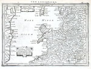
Lancastria, Cestria, Caernarvan
Publicado por Janssonius, Amsterdam, 1648
Librería: Antikvariat Krenek, Prag, Republica Checa
Miembro de asociación: ILAB
Calificación del vendedor: 5 de 5 estrellas
Mapa
EUR 75,00
Envío por EUR 14,50
Se envía de Republica Checa a Estados Unidos de AmericaCantidad disponible: 1 disponibles
Ańadir al carritoKein Einband. Condición: Sehr gut. North West England. "Lancastria, Cestria, Caernarvan, Denbich, Flint, Merionidh, Montgomery, Salopia, Cardigan, Radnor, Wigornia, et Ins. Anglesey". Orig. copperplate engraving from Mercator's Atlas Minor published in Amsterdam by J. Janssonius, 1648. With ornamental title cartouche, another cartouche with the scale of map and German title ("Von Engelandt") above the map. 14,5:20,5 cm (5 3/4 x 8 inch.). Koeman III, map 5111:352.1, ed. 352:32/33 (1648-51 German).
-

Eboracum, Lincolnia, Derbia
Publicado por Janssonius, Amsterdam, 1648
Librería: Antikvariat Krenek, Prag, Republica Checa
Miembro de asociación: ILAB
Calificación del vendedor: 5 de 5 estrellas
Mapa
EUR 75,00
Envío por EUR 14,50
Se envía de Republica Checa a Estados Unidos de AmericaCantidad disponible: 1 disponibles
Ańadir al carritoKein Einband. Condición: Sehr gut. North East England. "Eboracum, Lincolnia, Derbia, Staffordia, Notinghamia, Lecestria, Rutlandia, et Norfolcia". Orig. copperplate engraving from Mercator's Atlas Minor published in Amsterdam by J. Janssonius, 1648. With ornamental title cartouche, another cartouche with the scale of map and German title ("Von Engelandt") above the map. 14,5:20 cm (5 3/4 x 8 inch.). Koeman III, map 5510:352.1, ed. 352:32/33 (1648-51 German). - Map of northeastern England (counties of Yorkshire, Lincolnshire, Derbyshire, Staffordshire, Nottinghamshire, Leicestershire, Rutland a Norfolk).
-
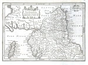
Northumbria, Cumberlandia, Dunelmensis episc. Westmorlandia, et Mania Ins.
Publicado por Janssonius, Amsterdam, 1648
Librería: Antikvariat Krenek, Prag, Republica Checa
Miembro de asociación: ILAB
Calificación del vendedor: 5 de 5 estrellas
Mapa
EUR 75,00
Envío por EUR 14,50
Se envía de Republica Checa a Estados Unidos de AmericaCantidad disponible: 1 disponibles
Ańadir al carritoKein Einband. Condición: Sehr gut. Northern England. "Northumbria, Cumberlandia, Dunelmensis episc. Westmorlandia, et Mania Ins.". Orig. copperplate engraving from Mercator's Atlas Minor published in Amsterdam by J. Janssonius, 1648. Orig. copperplate engraving from Mercator's Atlas Minor published in Amsterdam by J. Janssonius, 1648. With ornamental title cartouche, another cartouche with the scale of map and German title ("Von Engelandt") above the map 15:19,5 cm (6 x 7 3/4 inch.). Koeman III, map 5300:352.1, ed. 352:32/33 (1648-51 German). - A map of North England with the Isle of Man.
-

Devoniae Descriptio
Publicado por Janssonius, Amsterdam, 1648
Librería: Antikvariat Krenek, Prag, Republica Checa
Miembro de asociación: ILAB
Calificación del vendedor: 5 de 5 estrellas
Mapa
EUR 75,00
Envío por EUR 14,50
Se envía de Republica Checa a Estados Unidos de AmericaCantidad disponible: 1 disponibles
Ańadir al carritoKein Einband. Condición: Sehr gut. Devon. "Devoniae Descriptio. Petrus Kaerius Caelavit". Orig. copperplate engraving, P. van den Keere from Mercator's Atlas Minor published in Amsterdam by J. Janssonius, 1648. With ornamental title cartouche, the scale of map ("Milliaria Anglica") and German title ("Von Engelandt") above the map. 16:21 cm (6 1/4 x 8 1/4 inch.). Koeman III, map 5250:352.1, ed. 352:32/33 (1648-51 German).
-
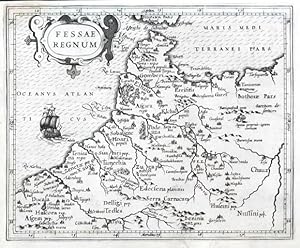
Fessae Regnum
Publicado por Hondius, Jodocus, Amsterdam, 1607
Librería: Antikvariat Krenek, Prag, Republica Checa
Miembro de asociación: ILAB
Calificación del vendedor: 5 de 5 estrellas
EUR 75,01
Envío por EUR 14,50
Se envía de Republica Checa a Estados Unidos de AmericaCantidad disponible: 1 disponibles
Ańadir al carritoMorocco. "Fessae Regnum". Orig. copperplate engraving from G. Mercator's Atlas Minor. Published in Amsterdam by J. Hondius, C. Claesz. and J, Jansz., 1607. With ornamental title-cartouche and a ship. 15,5:19 cm (6 1/4 x 7 1/2 inch.). Koeman III, map 8616:351, ed. 351:01 (1607 Atlas Minor). - A decorative miniature map of the northern part of Morocco (Fes) and western part of Algeria.


