
Importe total (1 artículo artículos):
Destino del pedido:

general drafting (42 resultados)
Ir a los resultados principales
Filtros de búsqueda
Tipo de artículo
- Todos los tipos de productos
- Libros (25)
- Revistas y publicaciones (No hay ningún otro resultado que coincida con este filtro.)
- Cómics (No hay ningún otro resultado que coincida con este filtro.)
- Partituras (No hay ningún otro resultado que coincida con este filtro.)
- Arte, grabados y pósters (No hay ningún otro resultado que coincida con este filtro.)
- Fotografías (No hay ningún otro resultado que coincida con este filtro.)
- Mapas (14)
- Manuscritos y coleccionismo de papel (3)
Condición Más información
Encuadernación
Más atributos
Idioma (2)
Gastos de envío gratis
Ubicación del vendedor
Valoración de los vendedores
-

Man's domain, a thematic atlas of the world: Mapping man's relationship with his environment
Idioma: Inglés
Publicado por McGraw-Hill Book Co (edition 3rd), 1975
ISBN 10: 0070230838 ISBN 13: 9780070230835
Librería: BooksRun, Philadelphia, PA, Estados Unidos de America
Calificación del vendedor: 5 de 5 estrellas

EUR 4,82
Gastos de envío gratis
Se envía dentro de Estados Unidos de AmericaCantidad disponible: 1 disponibles
Ańadir al carritoPaperback. Condición: Fair. 3rd. The item might be beaten up but readable. May contain markings or highlighting, as well as stains, bent corners, or any other major defect, but the text is not obscured in any way.
-
Man's domain, a thematic atlas of the world: Mapping man's relationship with his environment
Librería: Idaho Youth Ranch Books, Boise, ID, Estados Unidos de America
Calificación del vendedor: 5 de 5 estrellas
EUR 2,88
Envío por EUR 3,49
Se envía dentro de Estados Unidos de AmericaCantidad disponible: 1 disponibles
Ańadir al carritoCondición: Acceptable. COVER SHOWS WEAR. OTHERWISE IN GOOD CONDITION A readable copy. All pages are intact, and the cover is intact (However the dust cover may be missing). Pages can include considerable notes--in pen or highlighter--but the notes cannot obscure the text. Book may be a price cutter or have a remainder mark.
-
Man's domain, a thematic atlas of the world: Mapping man's relationship with his environment
Idioma: Inglés
Publicado por McGraw-Hill Book Co, New York, 1975
ISBN 10: 0070230838 ISBN 13: 9780070230835
Librería: Manning's Books & Prints, ABAA, Pacifica, CA, Estados Unidos de America
Miembro de asociación: ABAA ILAB
Calificación del vendedor: 3 de 5 estrellas

EUR 13,50
Envío por EUR 6,12
Se envía dentro de Estados Unidos de AmericaCantidad disponible: 1 disponibles
Ańadir al carritoSoft cover. Condición: Good. 3rd Edition. The Book Is In Good Condition, Pages & Binding Are Clean And Tight,
-

Africa Under Colonial Domination 1880-1935 (Volume 7) (General History of Africa)
Idioma: Inglés
Publicado por United Nations Educational Scientific and Cultural, 1990
ISBN 10: 923102499X ISBN 13: 9789231024993
Librería: WeBuyBooks, Rossendale, LANCS, Reino Unido
Calificación del vendedor: 5 de 5 estrellas
EUR 12,16
Envío por EUR 7,49
Se envía de Reino Unido a Estados Unidos de AmericaCantidad disponible: 1 disponibles
Ańadir al carritoCondición: Good. Most items will be dispatched the same or the next working day. A copy that has been read but remains in clean condition. All of the pages are intact and the cover is intact and the spine may show signs of wear. The book may have minor markings which are not specifically mentioned.
-

1946 NORTH & SOUTH CAROLINA ROAD MAP
Publicado por Esso Touring Service
Librería: Smokey Mountain Bookman, Franklin, NC, Estados Unidos de America
Calificación del vendedor: 5 de 5 estrellas
Mapa
EUR 8,10
Envío por EUR 4,37
Se envía dentro de Estados Unidos de AmericaCantidad disponible: 1 disponibles
Ańadir al carritoSoftcover. Condición: Good. [General Drafting Co., Inc. for Esso. 1946 NORTH & SOUTH CAROLINA ROAD MAP. Washington D.C.: Esso Touring Center (1946). Also showsprincipal highways of Georgia and Florida. Printed on both sides in color. 4" wide x 9" tall opens to 30" wide x 36" tall. Issued prior to Interstatehighways. Worn, soiled though complete. Some folds starting to separate. Few marginal annotations. About good.
-
1940 PENNSYLVANIA ESSO ROAD MAP
Publicado por General
Librería: Smokey Mountain Bookman, Franklin, NC, Estados Unidos de America
Calificación del vendedor: 5 de 5 estrellas
Mapa
EUR 9,46
Envío por EUR 4,37
Se envía dentro de Estados Unidos de AmericaCantidad disponible: 1 disponibles
Ańadir al carritoSoftcover. Condición: Fine. [General Drafting Company staff.] 1940 PENNSYLVANIA ESSO ROAD MAP - STANDARD OIL COMPANY OF PENNSYLVANIA. New York City:General Drafting Company, Inc. (1940). Printed in color on both sides. Insets for Philadelphia, Pittsburgh, etc. Indexed. Circa 32" wide x 48" tall.One drawn red marking (you can see through it) from Philadelphia to the west. Clean and properly folded. Gently toning. In fine condition.
-
MIAMI (FLORIDA) ROAD MAP
Publicado por Standard Oil
Librería: Smokey Mountain Bookman, Franklin, NC, Estados Unidos de America
Calificación del vendedor: 5 de 5 estrellas
Mapa
EUR 9,46
Envío por EUR 4,37
Se envía dentro de Estados Unidos de AmericaCantidad disponible: 1 disponibles
Ańadir al carritoSoftcover. Condición: Very Good. [General Drafting Co, Inc. staff.] 1954 STANDARD OIL MAP OF MIAMI AND VICINITY. (Publication location not listed.) Standard Oil of Kentucky1954. [Copyright by General Drafting Co., Inc., Convent Station, NJ.] Road and street map of Miami and Miami Beach. Also shows Palm Beach,West Palm Beach, Key West. Much color with color illustration of Crandon Park, Miami. Folded circa 4" wide x 8 1/4" tall opens to 23 1/2" by 161/2." Maps, text, color illustrations on both sides. Used. Generally quite good.
-

State of New Jersey 1931 Official Road Map: Showing State Highways and Other Principal Roads
Idioma: Inglés
Publicado por New Jersey. State Highway Commission, Trenton, 1931
Librería: The Librarian's Books, Cranford, NJ, Estados Unidos de America
Calificación del vendedor: 5 de 5 estrellas
EUR 13,50
Envío por EUR 4,37
Se envía dentro de Estados Unidos de AmericaCantidad disponible: 1 disponibles
Ańadir al carritoNo Binding. Condición: Fair. No Jacket. A Fair copy of a Used map that has been folded and refolded. Extensive wear to map with creasing, tears, sunning and staining. Tears along folded creases. The complete map of the state is in color, the others are in black & white. The state map includes a legend and "Approximate Population of Cities and Towns (1930)" The reverse contains smaller illustrations of "Picture Plan Showing Proposed State Highways And Main Connecting Roads in The Vicinity Of The New Hudson River Bridge";"Camden And Philadelphia";"Jersey City - Newark - Elizabeth - Paterson And Other Metropolitan New Jersey Motor Roads";"Proposed Highway Junction Routes 21, 25, And 29 Newark, New Jersey"; Trenton; Atlantic City; New Brunswick; "Distribution Plaza For New Jersey State Highways Approaching The Hudson River Bridge Between Fort Lee And New York City";"Following are some main through routes of New Jersey, with State Highway Route Numbers and Mileages" Also includes an introduction by the New Jersey Commissioner of Motor Vehicles. "Notes: Panel title. Text, official highway signs, table of highway route numbers and mileage, 7 ancillary maps, 2 views, and illustrations on verso. Ancillary maps on verso: Picture plan showing proposed state highways and main connecting roads in the vicinity of the new Hudson River bridge -- Trenton -- Atlantic City -- New Brunswick -- Camden and Philadelphia -- Jersey City, Newark, Elizabeth, Paterson, and other Metropolitan New Jersey motor roads. Views on verso: Proposed highway junction routes 21, 25, and 29 Newark, New Jersey -- Distribution plaza for New Jersey state highways approaching the Hudson River Bridge between Fort Lee and New York. Panel art: State outline with profile of Indian face." "Mathematic map data: Scale approximately 1:252,500 (W 75°3300--W 73°5000/N 41°2100--N 38°5500)." "Physical description: 1 map : color ; 100 x 53 cm, folded to 26 x 10 cm.".
-
FLORIDA WEST COAST ROAD MAP
Publicado por Standard Oil
Librería: Smokey Mountain Bookman, Franklin, NC, Estados Unidos de America
Calificación del vendedor: 5 de 5 estrellas
Mapa
EUR 11,70
Envío por EUR 4,37
Se envía dentro de Estados Unidos de AmericaCantidad disponible: 1 disponibles
Ańadir al carritoSoftcover. Condición: Fine. [General Drafting Col., Inc. staff.] 1957 STANDARD OIL MAP OF FLORIDA WEST COAST. (Publication location not listed.) Standard Oil ofKentucky 1957. (Copyright by General Drafting Co., Inc., Convent Station, NJ.) Detailed city maps of Tampa - St. Petersburg. Shows the WestCoast of Florida from about Clearwater south. Color photo on front of folded map of the Sunshine Skyway. Folded circa 4" wide x 8 1/4" tall opensto circa 23 2/2" by 16 1/2." Maps, text, color illustrations on both sides. Appears unused. In fine conditon.
-
1969 ESSO PENNSYLVANIA HIGHWAY MAP
Librería: Smokey Mountain Bookman, Franklin, NC, Estados Unidos de America
Calificación del vendedor: 5 de 5 estrellas
Mapa
EUR 7,20
Envío por EUR 4,37
Se envía dentro de Estados Unidos de AmericaCantidad disponible: 1 disponibles
Ańadir al carritoSoftcover. Condición: Very Good. [General Drafting Company staff for Esso.] 1969 ESSO PENNSYLVANIA HIGHWAY MAP. [Place of publication not listed.] Humble (Esso) Oil &Refining Company - copyright General Drafting Co., Inc. Convent Station, NJ MCMLXVIII (translates 1968). Pennsylvania state highway map issuedby Esso. Color. Printed both sides. Highway map on one side; index with city maps and information on the other. 8vo (circa 4 1/8" wide x 9 1/8" tallfolded - opens to circa 33" wide x 18 1/4" tall). Toned - folded sides dull with very minor stain. Unmarked, clean and uncreased. In very goodcondition.
-
1971 ESSO EASTERN STATES HIGHWAY MAP
Librería: Smokey Mountain Bookman, Franklin, NC, Estados Unidos de America
Calificación del vendedor: 5 de 5 estrellas
Mapa
EUR 7,20
Envío por EUR 4,37
Se envía dentro de Estados Unidos de AmericaCantidad disponible: 1 disponibles
Ańadir al carritoSoftcover. Condición: Very Good. [General Drafting Company staff for Esso.] 1971 ESSO EASTERN STATES (SOUTHERN) HIGHWAY MAP. New York City: Humble (Esso) TouringService - copyright General Drafting Co., Inc. Convent Station, NJ MCMLXXI (translates 1971). 1971 Esso Eastern States (southern) highway map.Color. Maps on both sides with mileage guide & information. 8vo (4" wide x 9 1/4" tall folded - opens to circa 24" wide x 27 3/4" tall). Tone and soilon folded sides. Unmarked, clean, uncreased. In very good condition.
-
1957 EASTERN UNITED STATES MAP
Publicado por Standard Oil Co.
Librería: Smokey Mountain Bookman, Franklin, NC, Estados Unidos de America
Calificación del vendedor: 5 de 5 estrellas
Mapa
EUR 8,10
Envío por EUR 4,37
Se envía dentro de Estados Unidos de AmericaCantidad disponible: 1 disponibles
Ańadir al carritoN/A. Condición: Very Good. [General Drafting Company staff.] 1957 EASTERN UNITED STATES and Adjacent Canada map. Convent Station, NJ: General Drafting Co. forStandard Oil Co. (1957). Maps printed in color on both sides. Rubber stamped in blank space by a Standard Oil Station in Ocala, Florida. Has acolor illustration of a yellow circa 1954 Oldsmobile convertible on a winding highway on the front cover. Measures about 4" wide x 8 1/2" tall closed and opens to circa 24 1/2" wide x 34 1/2" tall). Unmarked and properly folded though toning from age and their are some tiny holes where folded. In good or better condition.
-
Man's domain, a thematic atlas of the world: Mapping man's relationship with his environment
Librería: GoldBooks, Denver, CO, Estados Unidos de America
Calificación del vendedor: 5 de 5 estrellas
EUR 23,66
Envío por EUR 4,81
Se envía dentro de Estados Unidos de AmericaCantidad disponible: 1 disponibles
Ańadir al carritoPaperback. Condición: new. New Copy. Customer Service Guaranteed.
-
PLEASURE ISLAND; THE BOOK OF JAMAICA.
Publicado por Kingston, Jamaica: The Arawak Press Limited, 1968., 1968
Librería: David Hallinan, Bookseller, Columbus, MS, Estados Unidos de America
Calificación del vendedor: 5 de 5 estrellas
EUR 12,16
Envío por EUR 6,55
Se envía dentro de Estados Unidos de AmericaCantidad disponible: 1 disponibles
Ańadir al carritoRevised seventh edition. 306, [6] pages. Hardcover: H 21cm x L 14.25cm. Dust jacket lightly toned and soiled, bumping along top edges. Red cloth with vibrant silver stamping, bumping at spine ends and bottom board corners. Ink ownership inscription dated 1970 on half-title page. Interior pages are otherwise bright and clean. A very good copy in a very good dust jacket. With Foreword, Introduction, b/w photographs throughout, and advertisements on front endpapers and on six pages at rear. Also laid-in is a foldout pamphlet "Esso Jamaica Road Map" by Esso Standard Oil, S.A. copyright 1958 by General Drafting Co. Inc., Convent Station, NJ; approximate unfolded dimensions of H 42.5cm x L 61cm; full island map and Index on verso with recto featuring six close-up maps of Montego Bay, Port Antonio, Ocho Rios, Mandeville, Spanish Town, and Kingston-Lower St. Andrew (with accompanying street index).
-
Two 1951 road maps. {#1} OFFICIAL HIGHWAY MAP OF MISSISSIPPI. COMPLEMENTS STATE HIGHWAY DEPARTMENT and {#2} STANDARD OIL. MISSISSIPPI ARKANSAS LOUISIANA ROAD MAP WITH PICTORIAL GUIDE.
Publicado por Jackson, MS: Traffic & Planning Division for State Highway Commission [Mississippi State Highway Department - Mississippi Department of Transportation], July 1951. [Louisville, KY] - New York: Standard Oil Company (Kentucky) - General Drafting Co., Inc., 1951., 1951
Librería: David Hallinan, Bookseller, Columbus, MS, Estados Unidos de America
Calificación del vendedor: 5 de 5 estrellas
EUR 9,90
Envío por EUR 6,55
Se envía dentro de Estados Unidos de AmericaCantidad disponible: 1 disponibles
Ańadir al carrito{ITEM #1.} OFFICIAL HIGHWAY MAP OF MISSISSIPPI. COMPLEMENTS STATE HIGHWAY DEPARTMENT (with map legend title as "Official Road Map. State of Mississippi. Fielding L. Wright, Governor . . . "). Jackson, MS: Traffic & Planning Division for State Highway Commission, July 1951. Double-sided foldout color road map of Mississippi. Total of 8 panels per side. Approximate unfolded dimensions: H 17 inches x L 22 inches. Light toning and light creasing to exterior rear panel; a few edge nicks and negligibly small chips. Full-length color state map on verso primarily printed in white, black, and blue with extensive border area in pink with small inset maps for major towns. Map shows major state highways as paved or gravel (i.e. unpaved) as well as county borders, cities, towns, etc. Map title provides date of July 1951. Recto side features color photographs of state industry, agriculture, tourism-related, etc. with brief captions. {ITEM #2.} STANDARD OIL. MISSISSIPPI ARKANSAS LOUISIANA ROAD MAP WITH PICTORIAL GUIDE. [Louisville, KY] - New York: Standard Oil Company (Kentucky) - General Drafting Co., Inc., 1951. Double-sided foldout color road map. Total of 15 panels per side. Approximate unfolded dimensions: H 26 inches x L 19.25 inches. Library stamp on rear cover panel and short crease at bottom left corner. Full color highway map of the tri-state region on verso. Recto has mileage chart, town index, a "Pictorial Guide to Mississippi" map, and general maps for New Orleans, Natchez, Jackson, Vicksburg, and Memphis.
-

Washington, D.C., map and visitor's guide
Librería: Ezekial Books, LLC, Manchester, NH, Estados Unidos de America
Calificación del vendedor: 5 de 5 estrellas
EUR 44,97
Envío por EUR 4,33
Se envía dentro de Estados Unidos de AmericaCantidad disponible: 1 disponibles
Ańadir al carritohardcover. Condición: Good. No Highlighting or writing. Some Wear but overall good condition. 100% Satisfaction Guaranteed.
-
Of Maps and Mapping (First Edition)
Publicado por General Drafting Co., New York, 1959
Librería: Ziern-Hanon Galleries, Frontenac, MO, Estados Unidos de America
Calificación del vendedor: 1 de 5 estrellas

Original o primera edición
EUR 44,56
Envío por EUR 4,81
Se envía dentro de Estados Unidos de AmericaCantidad disponible: 1 disponibles
Ańadir al carritoFull Cloth. Condición: Very Good. No Jacket. First Edition. FIRST EDITION, first printing. Original full blue cloth hardcover. Comes with business card of the manager of Gerneral Drafting Co and a sheet describing the book. No previous owner's names, not exlibrary. Overall in VERY GOOD condition. Size: 4to - over 9ľ" - 12" tall. Hardcover.
-
Map of Colonial Williamsburg, Williamsburg, Virginia.
Publicado por Williamsburg, Va.: Colonial Williamsburg Foundation, ca. 1960s., 1960
Librería: Wittenborn Art Books, San Francisco, CA, Estados Unidos de America
Calificación del vendedor: 5 de 5 estrellas
Manuscrito
EUR 31,51
Envío por EUR 8,74
Se envía dentro de Estados Unidos de AmericaCantidad disponible: 1 disponibles
Ańadir al carritoCondición: Good. Folded color map measuring 18 x 24 inches, with index to buildings and sites of interest. Very good, suitable for framing.
-
Niane, D.T. (editor): Africa from the twelfth to the sixteenth century.
Publicado por Oxford, Heinemann, ,, 2000
Librería: Antiquariat Gothow & Motzke, Berlin, Alemania
Calificación del vendedor: 3 de 5 estrellas
EUR 48,00
Envío por EUR 9,95
Se envía de Alemania a Estados Unidos de AmericaCantidad disponible: 1 disponibles
Ańadir al carrito751 S./pp., Abbildungen (Illustrations), Originalleineneinband (publisher's cloth binding), Originalumschlag (publisher's dust jacket), sehr gutes Exemplar / book in excellent condition, (General History of Africa IV), Sprache: englisch.
-
Mokhtar, G. (editor): Ancient civilizations of Africa.
Publicado por Oxford, Heinemann, ,, 1995
Librería: Antiquariat Gothow & Motzke, Berlin, Alemania
Calificación del vendedor: 3 de 5 estrellas
EUR 48,00
Envío por EUR 9,95
Se envía de Alemania a Estados Unidos de AmericaCantidad disponible: 1 disponibles
Ańadir al carrito804 S./pp., Abbildungen (Illustrations), Originalleineneinband (publisher's cloth binding), Originalumschlag (publisher's dust jacket), sehr gutes Exemplar / book in excellent condition, (General History of Africa II),
-

Man's domain, a thematic atlas of the world
Librería: Basement Seller 101, Cincinnati, OH, Estados Unidos de America
Calificación del vendedor: 5 de 5 estrellas
EUR 112,44
Envío por EUR 4,37
Se envía dentro de Estados Unidos de AmericaCantidad disponible: 1 disponibles
Ańadir al carritopaperback. Condición: Very Good. 2nd. 1st edition from 1969.
-
Principal Highway Routes of the United States
Publicado por General Drafting Co. Inc, New York, 1933
Librería: Peruse the Stacks, ABAA, Gig Harbor, WA, Estados Unidos de America
Miembro de asociación: ABAA CBA ILAB
Calificación del vendedor: 5 de 5 estrellas
EUR 45,01
Envío por EUR 5,24
Se envía dentro de Estados Unidos de AmericaCantidad disponible: 1 disponibles
Ańadir al carritoFolding highway map of the US which includes inset map of "Washington, New York-Boston Section." Mileage table, text on the National Parks and the Transcontinental Tour, time zone map, and pictorial relief map on verso. Worldcat lists the date for this publication as 1931, but in the section on National Parks, the "new Trans-Mountain Highway," of Glacier National Park is mentioned, which was completed in 1933. An uncommon map. Folding map, 40x67cm, folded to 18x11cm. Good condition with toning, wear to folds, and a split to fold at bottom left panel. Former owner's annotations in pencil on both sides, with route from San Francisco to Providence traced neatly in green.
-
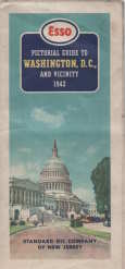
ESSO pictorial guide of Washington, D.C., and vicinity : our nation's capital
Publicado por Standard Oil Co., New York?, 1942
Librería: Harry E Bagley Books, Fredericton, NB, Canada
Calificación del vendedor: 4 de 5 estrellas

Mapa
EUR 27,01
Envío por EUR 26,22
Se envía de Canada a Estados Unidos de AmericaCantidad disponible: 1 disponibles
Ańadir al carritoNo Binding. Condición: Very Good. folding map,2 maps on 1 sheet : both sides, color ; 47 x 63 cm and 47 x 41 cm, sheet 50 x 66 cm, folded to 25 x 11 cm separation at 2 folds, some over all soil, Esso pictorial map of Washington, our nation's capital Happy motoring in Washington and vicinity Selected buildings shown pictorially on city map Panel title "Copyright, General Drafting Co., Inc." Includes text, indexes to points of interest, Alexandria inset, sector diagram, col. ill., and advertisement POSTAGE WILL BE REDUCED. Map.
-
![Imagen del vendedor de Markets of the world; a series of economic maps & statistical abstracts of the principal countries of the world . comp. by General drafting co., inc. 1920 [LeatherBound] a la venta por S N Books World](https://pictures.abebooks.com/inventory/md/md31376382995.jpg)
Markets of the world; a series of economic maps & statistical abstracts of the principal countries of the world . comp. by General drafting co., inc. 1920 [LeatherBound]
Idioma: Inglés
Ańo de publicación: 2025
Librería: S N Books World, Delhi, India
Calificación del vendedor: 5 de 5 estrellas
EUR 21,60
Gastos de envío gratis
Se envía de India a Estados Unidos de AmericaCantidad disponible: 18 disponibles
Ańadir al carritoLeatherBound. Condición: New. BOOKS ARE EXEMPT FROM IMPORT DUTIES AND TARIFFS; NO EXTRA CHARGES APPLY. Leatherbound edition. Condition: New. Leather Binding on Spine and Corners with Golden leaf printing on spine. Bound in genuine leather with Satin ribbon page markers and Spine with raised gilt bands. Pages: 58. A perfect gift for your loved ones. Reprinted from 1920 edition. NO changes have been made to the original text. This is NOT a retyped or an ocr'd reprint. Illustrations, Index, if any, are included in black and white. Each page is checked manually before printing. As this print on demand book is reprinted from a very old book, there could be some missing or flawed pages, but we always try to make the book as complete as possible. Fold-outs, if any, are not part of the book. If the original book was published in multiple volumes then this reprint is of only one volume, not the whole set. IF YOU WISH TO ORDER PARTICULAR VOLUME OR ALL THE VOLUMES YOU CAN CONTACT US. Resized as per current standards. Sewing binding for longer life, where the book block is actually sewn (smythe sewn/section sewn) with thread before binding which results in a more durable type of binding. Language: English Pages: 58.
-
![Imagen del vendedor de Of maps and mapping 1959 [LeatherBound] a la venta por S N Books World](https://pictures.abebooks.com/inventory/md/md30863607877.jpg)
Of maps and mapping 1959 [LeatherBound]
Idioma: Inglés
Ańo de publicación: 2025
Librería: S N Books World, Delhi, India
Calificación del vendedor: 5 de 5 estrellas
EUR 21,60
Gastos de envío gratis
Se envía de India a Estados Unidos de AmericaCantidad disponible: 18 disponibles
Ańadir al carritoLeatherbound. Condición: NEW. BOOKS ARE EXEMPT FROM IMPORT DUTIES AND TARIFFS; NO EXTRA CHARGES APPLY. Leatherbound edition. Condition: New. Leather Binding on Spine and Corners with Golden leaf printing on spine. Bound in genuine leather with Satin ribbon page markers and Spine with raised gilt bands. Pages: 64. A perfect gift for your loved ones. Reprinted from 1959 edition. NO changes have been made to the original text. This is NOT a retyped or an ocr'd reprint. Illustrations, Index, if any, are included in black and white. Each page is checked manually before printing. As this print on demand book is reprinted from a very old book, there could be some missing or flawed pages, but we always try to make the book as complete as possible. Fold-outs, if any, are not part of the book. If the original book was published in multiple volumes then this reprint is of only one volume, not the whole set. IF YOU WISH TO ORDER PARTICULAR VOLUME OR ALL THE VOLUMES YOU CAN CONTACT US. Resized as per current standards. Sewing binding for longer life, where the book block is actually sewn (smythe sewn/section sewn) with thread before binding which results in a more durable type of binding. Language: English Pages: 64.
-
A PICTORIAL MAP OF THE UNITED STATES OF AMERICA. Showing Principal Regional Resources, Products, and Natural Features.
Idioma: Inglés
Publicado por General Drafting Co, Inc., USA, 1958
Librería: Hornseys, Ripon, Reino Unido
Miembro de asociación: PBFA
Calificación del vendedor: 5 de 5 estrellas
EUR 114,55
Envío por EUR 29,27
Se envía de Reino Unido a Estados Unidos de AmericaCantidad disponible: 1 disponibles
Ańadir al carritoNo Binding. Condición: Very Good. General Drafting Co., Inc., New York, (c. late1950s). USA population stated as 175,000,000 in the notes on the map. Large colour pictorial map of the United States, with hundreds of illustrations showing regional resources, products, industries, agriculture, wildlife, landmarks, transport, cities and natural features. Includes Alaska, Hawaii, a forty-eight star American flag, and a "Facts About the United States" text panel. Sheet size approximately 73.8 × 56 cm. Original folds, light creasing and minor handling wear; very good condition overall, with bright colour. Recorded in institutional and commercial variants. Attractive mid-century American pictorial map by General Drafting Co.
-
![Imagen del vendedor de Markets of the world. : A series of economic maps & statistical abstracts of the principal countries of the world. / Compiled and published by the First National Bank of Boston, Mass., U.S.A 1920 [LeatherBound] a la venta por S N Books World](https://pictures.abebooks.com/inventory/md/md30638766926.jpg)
Markets of the world. : A series of economic maps & statistical abstracts of the principal countries of the world. / Compiled and published by the First National Bank of Boston, Mass., U.S.A 1920 [LeatherBound]
Idioma: Inglés
Ańo de publicación: 2025
Librería: S N Books World, Delhi, India
Calificación del vendedor: 5 de 5 estrellas
EUR 27,00
Gastos de envío gratis
Se envía de India a Estados Unidos de AmericaCantidad disponible: 18 disponibles
Ańadir al carritoLeatherbound. Condición: NEW. BOOKS ARE EXEMPT FROM IMPORT DUTIES AND TARIFFS; NO EXTRA CHARGES APPLY. Leatherbound edition. Condition: New. Leather Binding on Spine and Corners with Golden leaf printing on spine. Bound in genuine leather with Satin ribbon page markers and Spine with raised gilt bands. Pages: 146. A perfect gift for your loved ones. Reprinted from 1920 edition. NO changes have been made to the original text. This is NOT a retyped or an ocr'd reprint. Illustrations, Index, if any, are included in black and white. Each page is checked manually before printing. As this print on demand book is reprinted from a very old book, there could be some missing or flawed pages, but we always try to make the book as complete as possible. Fold-outs, if any, are not part of the book. If the original book was published in multiple volumes then this reprint is of only one volume, not the whole set. IF YOU WISH TO ORDER PARTICULAR VOLUME OR ALL THE VOLUMES YOU CAN CONTACT US. Resized as per current standards. Sewing binding for longer life, where the book block is actually sewn (smythe sewn/section sewn) with thread before binding which results in a more durable type of binding. Language: English Pages: 146.
-
![Imagen del vendedor de Markets of the world, United States & Canada series; a compilation of commercial maps & statistical data. Prepared and published by the First National Bank of Boston 1922 [LeatherBound] a la venta por S N Books World](https://pictures.abebooks.com/inventory/md/md30638764206.jpg)
Markets of the world, United States & Canada series; a compilation of commercial maps & statistical data. Prepared and published by the First National Bank of Boston 1922 [LeatherBound]
Idioma: Inglés
Ańo de publicación: 2025
Librería: S N Books World, Delhi, India
Calificación del vendedor: 5 de 5 estrellas
EUR 27,00
Gastos de envío gratis
Se envía de India a Estados Unidos de AmericaCantidad disponible: 18 disponibles
Ańadir al carritoLeatherbound. Condición: NEW. BOOKS ARE EXEMPT FROM IMPORT DUTIES AND TARIFFS; NO EXTRA CHARGES APPLY. Leatherbound edition. Condition: New. Leather Binding on Spine and Corners with Golden leaf printing on spine. Bound in genuine leather with Satin ribbon page markers and Spine with raised gilt bands. Pages: 82. A perfect gift for your loved ones. Reprinted from 1922 edition. NO changes have been made to the original text. This is NOT a retyped or an ocr'd reprint. Illustrations, Index, if any, are included in black and white. Each page is checked manually before printing. As this print on demand book is reprinted from a very old book, there could be some missing or flawed pages, but we always try to make the book as complete as possible. Fold-outs, if any, are not part of the book. If the original book was published in multiple volumes then this reprint is of only one volume, not the whole set. IF YOU WISH TO ORDER PARTICULAR VOLUME OR ALL THE VOLUMES YOU CAN CONTACT US. Resized as per current standards. Sewing binding for longer life, where the book block is actually sewn (smythe sewn/section sewn) with thread before binding which results in a more durable type of binding. Language: English Pages: 82.
-
Asia, Eastern Europe & Australia Reference & Resource Map
Idioma: Inglés
Publicado por Asia, Journal of the American Asiatic Association, New York, 1918
Librería: Dendera, London, Reino Unido
Calificación del vendedor: 5 de 5 estrellas
EUR 572,73
Envío por EUR 29,27
Se envía de Reino Unido a Estados Unidos de AmericaCantidad disponible: 1 disponibles
Ańadir al carritoNo Binding. Condición: Very Good. Colour printed paper map 97x86cm. Very good, neatly folded with closed fold tears. Compiled, engraved and printed by the General Drafting Co. Ltd, New York. Undated, but Worldcat entries generally estimate 1918-19. This is about consistent with the Turkish (Ottoman) border still extending through Mesopotamia to the head of the Persian Gulf. The Journal of the American Asiatic Association ran from 1898-1946. In 1917 it was bought by Willard and Dorothy Straight who prefixed the name with "Asia". Drawing on their experience promoting US trade and investment in Korea and China, it became a vehicle for the Straights to promote US influence across Asia by overcoming "the ignorance of our people" (March 1917 issue). This map was issued with that aim in mind. Centred on the Chinese Republic, coverage is bounded by Scotland (NW), the Gulf of Anadyr (NE), Arapura Sea (SE), and Arabian Sea (SW) on a scale of about 1 inch to 190 miles. Australia is shown in an inset at about 1 inch to 270 miles, with an inset for Tasmania. Details include international and provincial boundaries, 4 classes of settlement, 2 classes of railroad, caravan routes, steamship routes with distances, canals, heads of navigation, and seaports. Symbols are used for 17 types of mineral, agricultural product and fisheries, with several other resources or products named in the image. India for example is shown as widely rich in cattle and teak, with other significant resources including buffalo, sheep, jute, iron, coal and salt. The pre-oil Arabian Peninsula is labelled with pearls on the Persian Gulf and Red Sea coasts (the former naming Sharjah and Ras al Khaimah), dates, camels, horses, myrrh, and frankincense.
-
LYMAN LEMNITZER (Lyman Louis Lemnitzer / Lyman L. Lemnitzer, 1899-1988) US-General, im 2.Weltkrieg erreichte er die Kapitulation der dt. Armee in Italien u. südl. Österreich, 1955-57 UN-Kdr. in Korea / United States Army general who served as the fourth chairman of the Joint Chiefs of Staff from 1960 to 1962. He then served as the Supreme Allied Commander Europe of NATO from 1963 to 1969. As chairman of the Joint Chiefs of Staff, Lemnitzer was responsible for drafting Operation Northwoods, a proposed plan to create support for military action against Cuba, by orchestrating false flag terrorism acts in the United States.
Librería: Herbst-Auktionen, Detmold, Alemania
Calificación del vendedor: 3 de 5 estrellas
Manuscrito Ejemplar firmado
EUR 45,00
Envío por EUR 8,50
Se envía de Alemania a Estados Unidos de AmericaCantidad disponible: 1 disponibles
Ańadir al carritoBrief mit Ort, Datum, Unterschrift signiert - Begleitbrief ! Farbiges Wappen Supreme Allied Cdr. Europe - SHAPE 26.4.1969 (Typed Letter signed by US-General).


