Gall and inglis (25 resultados)

Idioma: Inglés
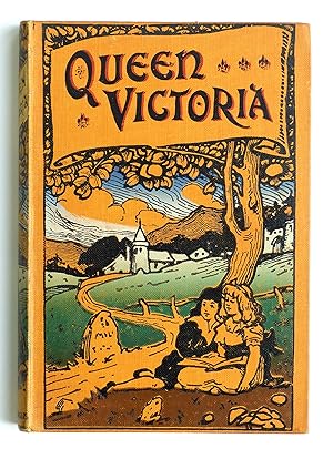
Editorial: Gall and Inglis, 1964
- Tapa dura
Librería: siop lyfrau'r hen bost, Blaenau Ffestiniog, Reino Unidosiop lyfrau'r hen bost
Contactar con el vendedorVendedor de 5 estrellasCondición: Usado - Aceptable
EUR 12,02
Envío por EUR 11,67Se envía de Reino Unido a Estados Unidos de AmericaCantidad disponible: 1 disponibles
Hardcover. Condición: Good. No Jacket. A Star Atlas and Reference Handbook (Epoch 1950) for students and amateurs. Slight damage to top of spine.
Editorial: Gall and Inglis
- Tapa dura
Librería: Anybook.com, Lincoln, Reino UnidoAnybook.com
Contactar con el vendedorVendedor de 5 estrellasCondición: Usado - Pobre
EUR 3,01
Envío por EUR 15,87Se envía de Reino Unido a Estados Unidos de AmericaCantidad disponible: 1 disponibles
Condición: Poor. This book has hardback covers. Ex-library, With usual stamps and markings, With owner's name inside cover. In poor condition, suitable as a reading copy. No dust jacket. Undated. Please note the Image in this listing is a stock photo and may not match the covers of the actual item,650grams, ISBN.

- Tapa blanda
Librería: PBShop.store UK, Fairford, GLOS, Reino UnidoPBShop.store UK
Contactar con el vendedorVendedor de 5 estrellasCondición: Nuevo
EUR 25,01
Envío por EUR 5,86Se envía de Reino Unido a Estados Unidos de AmericaCantidad disponible: 15 disponibles
PAP. Condición: New. New Book. Shipped from UK. Established seller since 2000.
Editorial: Gall and Inglis, London, 1957
- Tapa dura
Librería: Vashon Island Books, Vashon, WA, Estados Unidos de AmericaVashon Island Books
Contactar con el vendedorVendedor de 5 estrellasCondición: Usado - Bueno
EUR 17,96
Envío por EUR 4,81Se envía dentro de Estados Unidos de AmericaCantidad disponible: 1 disponibles
Hardcover. Condición: Very Good. No Dust Jacket. Thirteenth Edition. 4to - over 9¾" - 12" Tall. In blue cloth with gilt titling, 4to, 55pp + plates. A guidebook to 8,000 stars, clusters, nebulae, &tc and lists of 500 interesting objects. b/w Illustration (ilustrador).
 Más imágenes
Idioma: Inglés
Editorial: Gall and Inglis
- Tapa dura
Librería: Our Kind Of Books, Liphook, Reino UnidoOur Kind Of Books
Contactar con el vendedorVendedor de 5 estrellasCondición: Usado - Aceptable
EUR 12,02
Envío por EUR 25,85Se envía de Reino Unido a Estados Unidos de AmericaCantidad disponible: 1 disponibles
Hardcover. Condición: Good. No Jacket. Pictorial cloth boards with light sunning to spine and minor edge wear. Neat signatures to front end paper. Otherwise a very good clean copy. No publication date stated - assumed early 1900s.
Editorial: Gall and Inglis, London, 1959
- Tapa dura
Librería: Sheafe Street Books, Portsmouth, NH, Estados Unidos de AmericaSheafe Street Books
Contactar con el vendedorVendedor de 5 estrellasCondición: Usado - Bueno
EUR 22,51
Envío por EUR 3,50Se envía dentro de Estados Unidos de AmericaCantidad disponible: 1 disponibles
Hardcover. Condición: Very Good. Estado de la sobrecubierta: Good. 14th. Dust jacket has many small chips missing from the edges, now in mylar sleeve. Binding is tight, text is clean. End papers are decorated with star maps. 14 maps after the text.
 Más imágenes
Idioma: Inglés
Editorial: Gall & Inglis, Edinburgh and London, 1920
Librería: K Books Ltd ABA ILAB, York, YORKS, Reino UnidoK Books Ltd ABA ILAB
Contactar con el vendedorVendedor de 5 estrellasCondición: Usado - Bueno
EUR 8,42
Envío por EUR 22,76Se envía de Reino Unido a Estados Unidos de AmericaCantidad disponible: 1 disponibles
No Binding. Condición: Very Good. One folding PAPER map with blue card covers, scale of half an inch to a mile', very good condition, Gall & Inglis, Edinburgh and London, circa 1920s.
 Más imágenes
Editorial: Gall and Inglis, 1954
- Tapa dura
Librería: El Pinarillo Books, Morden, Reino UnidoEl Pinarillo Books
Contactar con el vendedorVendedor de 5 estrellasCondición: Usado - Aceptable
EUR 5,84
Envío por EUR 22,18Se envía de Reino Unido a Estados Unidos de AmericaCantidad disponible: 1 disponibles
Hardback. Condición: Good. No dustwrapper, maroon cloth. A little wear to cover, binding sound; good to very good overall. Book.
Editorial: Sky Publishing, 1966
- Tapa dura
Librería: San Marco Bookstore, Jacksonville, FL, Estados Unidos de AmericaSan Marco Bookstore
Contactar con el vendedorVendedor de 5 estrellasCondición: Usado - Bueno
EUR 19,77
Envío por EUR 8,96Se envía dentro de Estados Unidos de AmericaCantidad disponible: 1 disponibles
Hardcover. Condición: Very Good. Some light foxing on some pages.Hardcover. book.
Editorial: c, 1910
- Tapa blanda
- Mapa
Librería: AMBRA BOOKS (Aitchison & Cornish), Bristol, Reino UnidoAMBRA BOOKS (Aitchison & Cornish)
Contactar con el vendedorVendedor de 3 estrellasCondición: Usado
EUR 8,42
Envío por EUR 22,18Se envía de Reino Unido a Estados Unidos de AmericaCantidad disponible: 1 disponibles
Sheet 2, South Devon. Folding map printed in black and brown, linen- backed, folding into printed limp cloth wraps, 12mo. 1" repaired tear at edge. --- Please e-mail for one of my FREE CATALOGUES which include DEVON [ Manuscripts, Maps, Ephemera, Views, etc., etc. ] ---.
Editorial: c, 1910
- Tapa dura
- Mapa
Librería: AMBRA BOOKS (Aitchison & Cornish), Bristol, Reino UnidoAMBRA BOOKS (Aitchison & Cornish)
Contactar con el vendedorVendedor de 3 estrellasCondición: Usado
EUR 14,43
Envío por EUR 22,18Se envía de Reino Unido a Estados Unidos de AmericaCantidad disponible: 1 disponibles
Strip map, 5" wide, 36" long, folding into boards size 6" x 3«". On verso is 'The Brighton Road Map.' Printed in black and brown. The printed labels showing cyclist etc., are pasted to back and front boards. Labels rather rubbed. With gradient profile. --- Please e-mail for one of my FREE CATALOGUES which include GENERAL [ Manus…cripts, Maps, Ephemera, Views, etc., etc. ] ---.
Editorial: Sky Publishing, 1964
- Tapa dura
Librería: My Dead Aunt's Books, Hyattsville, MD, Estados Unidos de AmericaMy Dead Aunt's Books
Contactar con el vendedorVendedor de 5 estrellasCondición: Usado - Aceptable
EUR 32,42
Envío por EUR 4,81Se envía dentro de Estados Unidos de AmericaCantidad disponible: 1 disponibles
hardcover. Condición: Good. Estado de la sobrecubierta: Good. 13th edition. 1969 reprint. The pages are clean and unmarked with a stamp taped to the front flyleaf. The pages have yellowing to the edges. There are inserts that have light soiling. The cover has some light wear and bumping. The cover has some light soiling. The fro…nt gutter has some wear and is loose but still attatched.

Editorial: Edinburgh : Gall & Inglis, 1885
- Tapa dura
- Primera edición
Librería: MW Books, New York, NY, Estados Unidos de AmericaMW Books
Contactar con el vendedorVendedor de 5 estrellasCondición: Usado
EUR 38,27
Gastos de envío gratisSe envía dentro de Estados Unidos de AmericaCantidad disponible: 1 disponibles
1st edition. Good copy in the original title-blocked, illustrated cloth. Spine and panel edges somewhat bumped and rubbed as with age. Lightly browned and spotted. Remains quite well-preserved overall. * Estimated year of publication. Physical description; 60 pages, 15 cm. Subjects; Christian life ; Juvenile fiction. Children Co…nduct of life ; Juvenile fiction. Conduct of life ; Juvenile fiction. School children ; Juvenile fiction. Teachers ; Juvenile fiction. Honesty ; Juvenile fiction. Good and evil ; Juvenile fiction. 3 Kg.
Editorial: Gall and Inglis, Edinburgh, 1957
- Tapa dura
Librería: BOP Books, Tauranga, Nueva ZelandaBOP Books
Contactar con el vendedorVendedor de 1 estrellasCondición: Usado - Bueno
EUR 12,85
Envío por EUR 25,35Se envía de Nueva Zelanda a Estados Unidos de AmericaCantidad disponible: 1 disponibles
Hardcover. Condición: VG. No Jacket. 13th. Norton's Star Atlas was first published in 1910 and this 13th edition covers the "Epoc 1950". Norton died in 1955 and in this edition several changes were made at the suggestion of Dr E A Baker, formerly of the Royal Observatory, Edinburgh, and a number of alterations were made to the 1…920 epoc maps. J Gall Inglis was responsible for the reference handbook section. While mainly designed for student and amateur astronomers the atlas covers the whole star sphere, showing more than 900 stars, nebulae and clusters, technical information and notes on planets and star nomenclature. The first 55 pages are textual with tables , technical diagrams and advisory detail. The following pages have 18 star maps, each with descriptive text/tables, total pages just over 100. Both pastedowns show northern and souther map indices. Blue hard covers with gilt front title VG with light bumping to corners, spine with gilt titles sunned, first few pages show light foxing, but text block virtually free and excellent, former owner name top right title page, with owner stamp low on the page. Astronomical Charts, Tables (ilustrador).
Editorial: Sky Publishing, 1964
- Tapa dura
Librería: BookDepart, Shepherdstown, WV, Estados Unidos de AmericaBookDepart
Contactar con el vendedorVendedor de 5 estrellasCondición: Usado - Aceptable
EUR 37,42
Envío por EUR 7,38Se envía dentro de Estados Unidos de AmericaCantidad disponible: 1 disponibles
Hardcover. Condición: UsedGood. Hardback, fading, wear to exterior; former owner's name written on front end page; clean text, tight binding. Dust jacket, fading, numerous edge tears. ASIN: B000NQ97AU.

Editorial: Edinburgh : Gall & Inglis, 1885
- Tapa dura
- Primera edición
Librería: MW Books Ltd., Galway, IrlandaMW Books Ltd.
Contactar con el vendedorVendedor de 5 estrellasCondición: Usado
EUR 30,00
Envío por EUR 13,95Se envía de Irlanda a Estados Unidos de AmericaCantidad disponible: 1 disponibles
1st edition. Good copy in the original title-blocked, illustrated cloth. Spine and panel edges somewhat bumped and rubbed as with age. Lightly browned and spotted. Remains quite well-preserved overall. * Estimated year of publication. Physical description; 60 pages, 15 cm. Subjects; Christian life ; Juvenile fiction. Children Co…nduct of life ; Juvenile fiction. Conduct of life ; Juvenile fiction. School children ; Juvenile fiction. Teachers ; Juvenile fiction. Honesty ; Juvenile fiction. Good and evil ; Juvenile fiction. 1 Kg.
Editorial: Gall & Inglis Edinburgh, 1951
- Tapa dura
Librería: JIRI Books, Lisburn, Reino UnidoJIRI Books
Contactar con el vendedorVendedor de 5 estrellasCondición: Usado - Muy bueno
EUR 30,06
Envío por EUR 21,59Se envía de Reino Unido a Estados Unidos de AmericaCantidad disponible: 1 disponibles
Hardcover. Condición: Near Fine. Foolscap8vo, [848] p. Folding tables on the front and rear pastedowns. Original green boards, gilt. A near fine tight copy.
Editorial: Gall and Inglis, Edinburgh, 1943., 1943
Librería: Camberwell Books & Collectibles Pty Ltd, HAWTHORN EAST, VIC, AustraliaCamberwell Books & Collectibles Pty Ltd
Contactar con el vendedorVendedor de 3 estrellasMiembro de asociación: ILAB
Condición: Usado
EUR 12,49
Envío por EUR 32,35Se envía de Australia a Estados Unidos de AmericaCantidad disponible: 1 disponibles
55 pp including index, followed by 18 sky maps, quarto, sky maps on end papers, tables, charts, previous owner's name on front end-paper, piece missing from lower right-hand corner of d/j front, clean tears to d/j, d/j browned, cello-tape traces on end papers, else very good copy in good, illustrated d/j.
Editorial: Gall & Inglis, London & Edinburgh, 1943
- Tapa dura
Librería: Excalibur Books, Penzance, Reino UnidoExcalibur Books
Contactar con el vendedorVendedor de 3 estrellasCondición: Usado - Bueno
EUR 36,07
Envío por EUR 24,51Se envía de Reino Unido a Estados Unidos de AmericaCantidad disponible: 1 disponibles
Decorative Cloth. Condición: Very Good. Estado de la sobrecubierta: Fair. "Covering the whole Star Sphere, and showing over 8,000 Stars, Nebulae and Clusters; with short Descriptive Lists od Objects suitable for Small Telescopes; Notes on Planets, Star Nomenclature etc." Royal Blue cloth cover with bright gilt lettering and illu…stration of Atlas holding the globe, on the the front. Buff jacket has same illustration and lettering. 11 1/2" Tall. NIce clean copy. Previous owner's name finely written on title page. Jacket has some small pieces missing, along spine and corners, and a long closed tear along the fore edge (repaired on the inside with tape). See photo. Size: 4to - over 9¾" - 12" tall.
Gall And Inglis Map Of London. Scale : Five Inches To A Mile. With Handbook & Index Of 5000 Streets.
Idioma: Inglés
Editorial: Gall And Inglis., London.
- Tapa dura
Librería: James Hine, Ilminster, SOMER, Reino UnidoJames Hine
Contactar con el vendedorVendedor de 4 estrellasMiembro de asociación: PBFA
Condición: Usado - Bueno
EUR 150,28
Envío por EUR 40,85Se envía de Reino Unido a Estados Unidos de AmericaCantidad disponible: 1 disponibles
Hardcover. Condición: Very Good. No Jacket. 5th or later Edition. Edition not stated, Nd. c. 1900. Map mounted on heavy grained linen with one split along a small section. Some light fraying to edges. The handbook of London mounted in the front of the folding pocket book has become loose which has slightly torn and split the cov…ers of the booklet, one piece of the top of inner hinge torn away (still present). Pocket book still in good condition. The whole mounted in highly decorative red cloth folder which is very slightly faded and marked. Still a very good bright clean copy. Larg folding coloured map of london and with two maps mounted on the verso. (ilustrador).

Editorial: Gall and Inglis nd. ca 1850s, Edinburgh, 1850
- Tapa dura
Librería: Attic Books (ABAC, ILAB), London, ON, CanadaAttic Books (ABAC, ILAB)
Contactar con el vendedorVendedor de 5 estrellasCondición: Usado - Aceptable
EUR 67,53
Envío por EUR 13,11Se envía de Canada a Estados Unidos de AmericaCantidad disponible: 1 disponibles
Hardcover. Condición: Good. 48 p. 15 cm. Frontispiece illustration.Leather spine with cloth boards. Chipped spine head and torn tail. Ink inscription on front free endpaper. Foxing.
Editorial: Gall & Inglis, 1942
- Tapa dura
Librería: Stephen White Books, Bradford, Reino UnidoStephen White Books
Contactar con el vendedorVendedor de 5 estrellasCondición: Usado - Aceptable
EUR 538,49
Envío por EUR 38,81Se envía de Reino Unido a Estados Unidos de AmericaCantidad disponible: 1 disponibles
Hardcover. Condición: Good. Not Ex-Library. Hardback/Hardcover. Clean copy in good condition. Quick dispatch from UK seller.
 Más imágenes
Editorial: Gall and Inglis, 1861
- Tapa dura
Librería: Schilb Antiquarian, Columbia, MO, Estados Unidos de AmericaSchilb Antiquarian
Contactar con el vendedorVendedor de 5 estrellasCondición: Usado - Muy bueno
EUR 675,32
Gastos de envío gratisSe envía dentro de Estados Unidos de AmericaCantidad disponible: 1 disponibles
Hardcover. Condición: Near Fine. 1861 RARE Gall Inglis ATLAS Geography China America Australia 31 COLOR MAPS Gall and Inglis' "School Atlas of Modern Geography" is a civil war compilation of 31 royal quarto maps. This 1861 edition includes maps of Europe, England and Wales, Ireland, Scotland, North America, South America, Switze…rland, Turkey, Hindostan, and much more! Item number: #13467 Price: $750 Gall and Inglis Gall and Inglis' School Atlas of Modern Geography Edinburgh: Gall & Inglis, 1861. Details: Collation: Complete with all pages 31 color maps Language: English Binding: Hardcover; tight & secure Cloth Size: ~12.5in X 9.75in (31.5cm x 25cm) Our Guarantee: Very Fast. Very Safe. Free Shipping Worldwide. Customer satisfaction is our priority! Notify us with 7 days of receiving, and we will offer a full refund without reservation! 13467 Photos available upon request.
Editorial: Gall and Inglis
Librería: Fireside Bookshop, Stroud, GLOS, Reino UnidoFireside Bookshop
Contactar con el vendedorVendedor de 5 estrellasMiembro de asociación: PBFA
Condición: Usado - Aceptable
EUR 60,11
Envío por EUR 29,18Se envía de Reino Unido a Estados Unidos de AmericaCantidad disponible: 1 disponibles
No Binding. Condición: Good. No Jacket. Type: Book Map. Scale half an inch to a mile. Map in very good, bright condition, case is marked and has some fading and rubbing. Undated. please contact us if you would like to see photographs. (LONDON).
 Más imágenes
Librería: James M Pickard, ABA, ILAB, PBFA., LEICESTER, Reino UnidoJames M Pickard, ABA, ILAB, PBFA.
Contactar con el vendedorVendedor de 5 estrellasCondición: Usado
EUR 36,07
Envío por EUR 26,85Se envía de Reino Unido a Estados Unidos de AmericaCantidad disponible: 1 disponibles
(London: Gall and Inglis nd circa 1900) . Softcover. A VG+ copy. Illustrated card covers. Fold out map of Leicestershire Map is intact and in fine condition. Map in 24 parts folds into the original softcover wrappers. A lovely VG+ copy (no inscriptions, no book-plates). 6' x 3.5'. Photographs/scans available upon request.


