
Importe total (1 artículo artículos):
Destino del pedido:

eddy gerald (26 resultados)
Ir a los resultados principales
Filtros de búsqueda
Tipo de artículo
- Todos los tipos de productos
- Libros (20)
- Revistas y publicaciones (No hay ningún otro resultado que coincida con este filtro.)
- Cómics (No hay ningún otro resultado que coincida con este filtro.)
- Partituras (No hay ningún otro resultado que coincida con este filtro.)
- Arte, grabados y pósters (No hay ningún otro resultado que coincida con este filtro.)
- Fotografías (No hay ningún otro resultado que coincida con este filtro.)
- Mapas (4)
- Manuscritos y coleccionismo de papel (2)
Condición Más información
- Nuevo (9)
- Como nuevo, Excelente o Muy bueno (No hay ningún otro resultado que coincida con este filtro.)
- Bueno o Aceptable (2)
- Regular o Pobre (No hay ningún otro resultado que coincida con este filtro.)
- Tal como se indica (15)
Encuadernación
Más atributos
- Primera edición (6)
- Firmado (No hay ningún otro resultado que coincida con este filtro.)
- Sobrecubierta (1)
- Con imágenes (13)
- No impresión bajo demanda (19)
Idioma (2)
Gastos de envío gratis
Ubicación del vendedor
Valoración de los vendedores
-
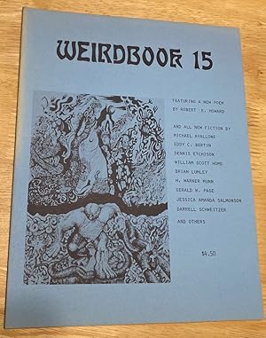
Weirdbook 15 The photos in this listing are of the item offered for sale.
Publicado por Weirdbook Press / W. Paul Ganley, Buffalo, 1981
Librería: biblioboy, North Providence, RI, Estados Unidos de America
Calificación del vendedor: 5 de 5 estrellas

Original o primera edición
EUR 9,04
Envío por EUR 6,14
Se envía dentro de Estados Unidos de AmericaCantidad disponible: 1 disponibles
Ańadir al carritoSingle Issue Magazine. Condición: Very Good. First Edition. Buffalo: Weirdbook Press / W. Paul Ganley.1981. First Edition Magazine. Oversize [about 8.5" x 11"] wrappers. 65+ pages, illustrated. Very good copy with age-toning to the edges and one tiny spot stain to spine. 150, 14,mag6.
-

500 Boylston Street Project, Mepa Environmental Impact Report: Final
Librería: Ria Christie Collections, Uxbridge, Reino Unido
Calificación del vendedor: 5 de 5 estrellas
EUR 17,76
Envío por EUR 13,88
Se envía de Reino Unido a Estados Unidos de AmericaCantidad disponible: Más de 20 disponibles
Ańadir al carritoCondición: New. In.
-

500 Boylston Street Project, Mepa Environmental Impact Report: Final
Librería: Ria Christie Collections, Uxbridge, Reino Unido
Calificación del vendedor: 5 de 5 estrellas
EUR 31,27
Envío por EUR 13,88
Se envía de Reino Unido a Estados Unidos de AmericaCantidad disponible: Más de 20 disponibles
Ańadir al carritoCondición: New. In.
-

The Resurrection: An Interdisciplinary Symposium on the Resurrection of Jesus
Idioma: Inglés
Publicado por Oxford University Press, Oxford, England / New York, New York, 1997
ISBN 10: 0198150911 ISBN 13: 9780198150916
Librería: Andover Books and Antiquities, Andover, MA, Estados Unidos de America
Calificación del vendedor: 4 de 5 estrellas

EUR 90,42
Envío por EUR 11,41
Se envía dentro de Estados Unidos de AmericaCantidad disponible: 1 disponibles
Ańadir al carritoHardcover. Estado de la sobrecubierta: dj. xi, 368 pp. Proceedings of the Resurrection Summit at Dunwoodie, New York, 7-10 April 1996. Dustjacket. Very good condition; touches of wear on covers.
-

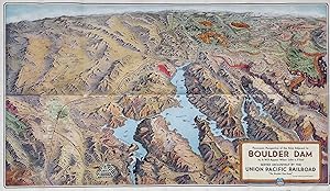
Union Pacific Boulder Dam Route--Facts Concerning Boulder Dam with Stunning Bird's Eye View Map
Publicado por Union Pacific, 1935
Librería: Stellar Books & Ephemera, ABAA, Carlsborg, WA, Estados Unidos de America
Miembro de asociación: ABAA ILAB
Calificación del vendedor: 5 de 5 estrellas
Manuscrito
EUR 81,38
Envío por EUR 7,02
Se envía dentro de Estados Unidos de AmericaCantidad disponible: 1 disponibles
Ańadir al carritoUnion Pacific Boulder Dam Route--Facts Concerning Boulder Dam with Stunning Bird's Eye View Map 9 x 4-inch folding brochure which unfolds into pictorial bird's eye view map, 18 x 31 inches. Good condition. Rubbing to color cover with moderate edge wear. Beautiful full color bird's eye view map of the region surrounding Boulder Dam. Includes Salt Lake City to the north to Boulder City in the south, and from Las Vegas in the west to the Grand Canyon in the east. The map portrays Boulder City larger than Las Vegas. Gambling was legalized in 1931 but dramatic growth of Vegas took place after World War Two. Pamphlet extols the virtue of the recently completed Boulder Dam, "Down in the rock-walled recesses of the Black Canyon of the Colorado River, an army of men and a vast array of titan machinery are busily engaged in the construction of one of the greatest engineering project of its kind the world has ever known - Boulder Dam." And of course, much ink is spilled on the greatness of the Union Pacific Railroad. The Bird's Eye View Map is quite nice and "suitable for framing.".
-
Facts Concerning Boulder Dam--On to Salt Lake It's Up to U-tah
Publicado por Union Pacific, 1936
Librería: Stellar Books & Ephemera, ABAA, Carlsborg, WA, Estados Unidos de America
Miembro de asociación: ABAA ILAB
Calificación del vendedor: 5 de 5 estrellas
Manuscrito
EUR 90,42
Envío por EUR 7,02
Se envía dentro de Estados Unidos de AmericaCantidad disponible: 1 disponibles
Ańadir al carritoFacts Concerning Boulder Dam--On to Salt Lake It's Up to U-tah 9 x 4-inch folding brochure which unfolds into pictorial bird's eye view map, 18 x 31 inches. Fine condition with just a couple very small blemishes along edges. Beautiful full color bird's eye view map of the region surrounding Boulder Dam. Includes Salt Lake City to the north to Boulder City in the south, and from Las Vegas in the west to the Grand Canyon in the east. The map portrays Boulder City larger than Las Vegas. Gambling was legalized in 1931 but dramatic growth of Vegas took place after World War Two. Pamphlet extols the virtue of the recently completed Boulder Dam, "Down in the rock-walled recesses of the Black Canyon of the Colorado River, an army of men and a vast array of titan machinery are busily engaged in the construction of one of the greatest engineering project of its kind the world has ever known - Boulder Dam." And of course, much ink is spilled on the greatness of the Union Pacific Railroad. This pamphlet also has a label on the front panel which reads, "On to Salt Lake It's Up to U-tah", which we have never seen before on this colorful travel pamphlet. As they say, "suitable for framing.".
-
500 Boylston Street Project, Mepa Environmental Impact Report: Final
Librería: Majestic Books, Hounslow, Reino Unido
Calificación del vendedor: 4 de 5 estrellas
EUR 26,22
Envío por EUR 7,53
Se envía de Reino Unido a Estados Unidos de AmericaCantidad disponible: 4 disponibles
Ańadir al carritoCondición: New. Print on Demand.
-
500 Boylston Street Project, Mepa Environmental Impact Report: Final
Librería: Books Puddle, New York, NY, Estados Unidos de America
Calificación del vendedor: 4 de 5 estrellas
EUR 31,18
Envío por EUR 3,50
Se envía dentro de Estados Unidos de AmericaCantidad disponible: 4 disponibles
Ańadir al carritoCondición: New. Print on Demand.
-
(cal eph 1) Lake Tahoe Sierra Association 1950 fold our Map by Gerald A. Eddy
Publicado por Lake Tahoe Sierra Association, 1950
Librería: Wonderland Books, Berkeley, CA, Estados Unidos de America
Calificación del vendedor: 4 de 5 estrellas
Mapa
EUR 108,50
Envío por EUR 4,39
Se envía dentro de Estados Unidos de AmericaCantidad disponible: 1 disponibles
Ańadir al carritoSoft cover. Condición: Very Good. Map folds out to 24 X 18 inches- near very good condition with bit of wear and a few short edge fold mark tears and a 2 inch fold mark tear on the map which is barely visible when the map is opened up-.
-
500 Boylston Street Project, Mepa Environmental Impact Report: Final
Librería: Biblios, Frankfurt am main, HESSE, Alemania
Calificación del vendedor: 4 de 5 estrellas
EUR 25,66
Envío por EUR 9,95
Se envía de Alemania a Estados Unidos de AmericaCantidad disponible: 4 disponibles
Ańadir al carritoCondición: New. PRINT ON DEMAND.
-
Publication 50 An Index of the Geology of Michigan 1823-1955
Publicado por Speaker-Hines & Thomas, Inc., State Printers, Lansing, Mich., USA, 1956
Librería: Bücher-Insel Antiquariat Rolf Selbert, Kassel, Alemania
Calificación del vendedor: 4 de 5 estrellas
EUR 40,00
Envío por EUR 40,00
Se envía de Alemania a Estados Unidos de AmericaCantidad disponible: 1 disponibles
Ańadir al carrito461 S. Englischer Buchtext. Vorne ausfaltbare Landkarten. Schnitte teils Altersspuren und wenige Druckstellen vorne wegen der Landkarten, sonst gut.
-
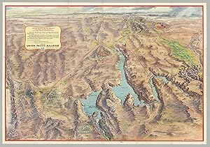
MAP OF LAKE TAHOE CALIFORNIA - NEVADA [cover title]
Publicado por Press of Perkins & Smith Co, [Los Angeles, 1930
Librería: Currey, L.W. Inc. ABAA/ILAB, Elizabethtown, NY, Estados Unidos de America
Miembro de asociación: ILAB
Calificación del vendedor: 4 de 5 estrellas
EUR 90,42
Envío por EUR 6,14
Se envía dentro de Estados Unidos de AmericaCantidad disponible: 1 disponibles
Ańadir al carritoSingle sheet, 15.5x23.2 cm, folded to make four panels. Printed on blue paper. 1 illustration, 1 map. Promotional leaflet for the 100-acre Camp Richardson Resort on the south shore of Lake Tahoe. Gerald A. Eddy's two-panel map is small but remarkably detailed, showing dozens of tourist facilities lining the lake, as well as points of interest in the region. The Desolation Valley Primitive Area, set aside in 1931, is shown and so named on the map. Vertical fold, front panel dusty. (#172923).
-
Travel the Pacific Coast with Gilmore Red Lion the record breaker, purest Pennsylvania motor oil. . . with the gasoline champions use. . . [Pictorial automobile travel maps for California, Oregon & Washington].
Publicado por Gilmore Gasoline, ca. 1930]., [Los Angeles, CA:, 1930
Librería: Zephyr Used & Rare Books, Vancouver, WA, Estados Unidos de America
Miembro de asociación: ABAA CBA ESA ILAB
Calificación del vendedor: 5 de 5 estrellas
Original o primera edición
EUR 90,42
Envío por EUR 7,02
Se envía dentro de Estados Unidos de AmericaCantidad disponible: 1 disponibles
Ańadir al carritoSmall 4to. sized 4.5 x 6 in. which opens out into 14 x 24 in. colour pictorial maps by Eddy, self-printed colour-illustrated softcovers of vivid cover art of race car chasing Gilmore lion past the checkered flag (some dustsoiling, wear, very minor chip at upper fore-edge, minor wear to fold creases), still VG- copy. First edition of this very scarce automobile travel map for the West Coast issued by Gilmore Gasoline. After taking over for his father Arthur Gilmore in 1918, Earl Bell Gilmore quickly built the Gilmore Oil Company into the largest on the West Coast, sponsonring auto races, air races, speed record attempts, and the glistening Art Deco Gilmore gas stations were the cleanest and most modern. Gerald Eddy was a noted Los Angeles, CA cartographer whose pictorial maps graced land promotions for Lake Tahoe, the stunning Frank Meline Los Angeles piece, and more. No copies in Worldcat.
-
500 Boylston Street Project, Mepa Environmental Impact Report: Final
Librería: Majestic Books, Hounslow, Reino Unido
Calificación del vendedor: 4 de 5 estrellas
EUR 37,91
Envío por EUR 7,53
Se envía de Reino Unido a Estados Unidos de AmericaCantidad disponible: 4 disponibles
Ańadir al carritoCondición: New. Print on Demand.
-
500 Boylston Street Project, Mepa Environmental Impact Report: Final
Librería: Books Puddle, New York, NY, Estados Unidos de America
Calificación del vendedor: 4 de 5 estrellas
EUR 44,02
Envío por EUR 3,50
Se envía dentro de Estados Unidos de AmericaCantidad disponible: 4 disponibles
Ańadir al carritoCondición: New. Print on Demand.
-
Panoramic Perspective Map of the Area Adjacent to Boulder Dam. As It Will Appear When Lake is Filled. Served Exclusively by the Union Pacific Railroad 'The Boulder Dam Route.'
Publicado por Union Pacific Railroad, [Omaha, NE], 1938
Librería: Tschanz Rare Books, Salt Lake City, UT, Estados Unidos de America
Miembro de asociación: ABAA ILAB RMABA
Calificación del vendedor: 3 de 5 estrellas

Mapa
EUR 135,63
Envío por EUR 4,39
Se envía dentro de Estados Unidos de AmericaCantidad disponible: 1 disponibles
Ańadir al carritoColor birds-eye map [46 cm x 78 cm]. Better than very good. Folds as issued. Map drawn by Gerald A. Eddy. Charming birds-eye map produced by the railroad to try to entice tourists to the Mojave, southern Nevada (this was before Las Vegas was "Las Vegas"), and the surrounding area, that was also served by the U.P. and the Utah Parks Company, with the lodges at Bryce, Zion, Cedar Breaks. and the North Rim of the Grand Canyon located. Valley of Fire and Buried City are also located. The reverse contains information on the Dam and area, including descriptions of the location, the hydroelectric capabilities, Boulder City, Las Vegas and recreational suggestions. "Down in the rock-walled recesses of the Black Canyon of the Colorado River, an army of men and a vast array of titan machinery are busily engaged in the construction of one of the greatest engineering project of its kind the world has ever known - Boulder Dam.".
-
500 Boylston Street Project, Mepa Environmental Impact Report: Final
Librería: Biblios, Frankfurt am main, HESSE, Alemania
Calificación del vendedor: 4 de 5 estrellas
EUR 37,92
Envío por EUR 9,95
Se envía de Alemania a Estados Unidos de AmericaCantidad disponible: 4 disponibles
Ańadir al carritoCondición: New. PRINT ON DEMAND.
-
Panoramic Perspective Map of Boulder Dam and Adjacent Area as it Will Appear When Lake is Filled
Publicado por Union Pacific System, [Omaha, NE], 1935
Librería: Carpe Diem Fine Books, ABAA, Monterey, CA, Estados Unidos de America
Miembro de asociación: ABAA ILAB TXBA
Calificación del vendedor: 5 de 5 estrellas
EUR 142,86
Envío por EUR 4,35
Se envía dentro de Estados Unidos de AmericaCantidad disponible: 1 disponibles
Ańadir al carritoColor birds-eye perspective map drawn by Gerald A. Eddy (46 x 78 cm), folded into self-wrappers. On verso: text, illustrations, and "Map of the Union Pacific System and through car lines." Printed by Poole Bros. in Chicago. A near fine copy (3 short splits at edges, not affecting the map), A colorful tourist promotional map showing the locations of important nationals parks, monument, lodges and cities including Bryce, Zion, Cedar Breaks, Grand Canyon, Valley of Fire, Las Vegas, Boulder City and more. The reverse side of the map includes Facts Concerning Boulder Dam, How to Visit, and information about Boulder City and Las Vegas.
-
Fold-O-Globe
Publicado por Gerald A. Eddy, Glendale, California, 1942
Librería: Argosy Book Store, ABAA, ILAB, New York, NY, Estados Unidos de America
Miembro de asociación: ABAA ILAB
Calificación del vendedor: 5 de 5 estrellas
EUR 167,27
Envío por EUR 5,27
Se envía dentro de Estados Unidos de AmericaCantidad disponible: 1 disponibles
Ańadir al carritounbound. Map. Lithograph. 9.75 x 8.75 inches. In very good condition. Comes with original glycine printed envelope. Glendale, CA: Fold-O-Globe, (1942). Delightful three dimensional folding globe. Continuous map projection showing the globe in 4 sides. Shows axis controlled areas and British territories. The design was patented by the artist. Gerald Allen Eddy (1889 - 1967) was from Michigan and moved to Southern California in 1902. He worked in Los Angeles as an artist and commercial cartographer.
-
Panoramic Perspective of the Area Adjacent to Las VegasHoover Dam, Lake Mead National Recreation Area; Las VegasHoover Dam, Lake Mead National Recreation Area
Publicado por Glendale, CA: Gerald A. Eddy; Union Pacific Railroad, 1958, 1958
Librería: James Arsenault & Company, ABAA, Arrowsic, ME, Estados Unidos de America
Miembro de asociación: ABAA ESA ILAB
Calificación del vendedor: 5 de 5 estrellas
Mapa
EUR 266,73
Envío por EUR 8,12
Se envía dentro de Estados Unidos de AmericaCantidad disponible: 1 disponibles
Ańadir al carritoFolding color process map, 22" x 31", 18 panels of illus. and text on verso, folded size 7.5" x 5.25". A striking post-WWII panoramic map of the Southwest including portions of Nevada and Arizona, as well as California's Death Valley and Utah's Zion, Bryce and Cedar Breaks areas, depicting the vast region accessible via the Union Pacific Railroad, including its mountains, cliffs, washes, plateaus, mines, Hoover and other dams, Nellis Air Force Base, the Atomic Energy Commission testing grounds, Indian reservations, Valley of Fire state park, numerous national parks, forests, and monuments, the Colorado River supplying Lake Mead, and Boulder City and Las Vegas with street grids showing hotel locations. The map ranges from the Grand Canyon in the East to Death Valley and the Yucca Flats in the West; and from Boulder City in the south to Salt Lake City in the North. The Union Pacific Railroad lines are delineated in red; elevations are indicated for mountains and terrain within state and national parks; and bodies of water show depths and state boundaries. Promotional text and colorful illustrations of Las Vegas appear on the verso. An engineering marvel, Hoover Dam and Lake Mead became a tourist attraction during the post-war boom. The project opened up the west for development, providing water from the once-wild Colorado River to the arid Southwest, leading to the expansion of such major cities as Los Angeles, Las Vegas and Phoenix, as well as the growth of railroad lines, national recreational areas, and military installations. CONDITION: Good, blue ink routes discreetly traced on Rt. 95 and Rt 89.
-
Les histoires vraies de l'Oncle Paul, tome 12 : Chasseurs de Tombeaux. 15 Histoires palpitantes et véridiques sur les hommes les plus remarquables.
Librería: Librairie Victor Sevilla, Paris, Francia
Calificación del vendedor: 5 de 5 estrellas
Original o primera edición
EUR 880,00
Envío por EUR 35,00
Se envía de Francia a Estados Unidos de AmericaCantidad disponible: 1 disponibles
Ańadir al carritoEditions Dupuis 1955. In-4 relié de 64 pages au format 28,5 x 20 cm. Couvertures de Eddy Paape. Dos rond, muet, toilé rouge. Plats avec infimes frottis aux coins. Intérieur en superbe état de fraicheur malgré un nom inscrit en page de garde ( masqué au stylo bille ). Les histoires vraies de l'oncle Paul n° 12 contenant 15 histoires avec dessins en couleurs par Hope, René Follet, Jean Graton, Eddy Paape, Pierre Dupuis, Dehon, Hidalgo, Gérald Forton, sur scénarios de Octave Joly, Jean-Michel Charlier, Gramberger et Roquet. Le plus rare volume de la série. Rarissime édition originale surtout dans un aussi magnifique état général de fraicheur.
-
Alaska to Mexico.
Ańo de publicación: 1960
Librería: Geographicus Rare Antique Maps, Brooklyn, NY, Estados Unidos de America
Miembro de asociación: ABAA ESA ILAB
Calificación del vendedor: 4 de 5 estrellas
Mapa
EUR 151,90
Envío por EUR 14,92
Se envía dentro de Estados Unidos de AmericaCantidad disponible: 1 disponibles
Ańadir al carritoVery good. Minor wear long fold lines. Size 27 x 4 Inches. A c. 1960 strip road map by Gerald Eddy, produced for the Harolds Club casino in Reno, Nevada. Between the recto and verso, the entire route from Nome, Alaska, to the Mexico-Guatemala border is charted, with primacy of place given to Reno and Harolds Club specifically. A Closer Look The recto traces the route from Nome and Fairbanks, Alaska, to Reno (largely along U.S. Route 97), while the verso continues from Reno through Las Vegas, Phoenix, Tucson (along U.S. Route 93), Hermosillo, Mazatlán, Guadalajara, Mexico City, and eventually to the border with Guatemala. Other routes to Reno from Seattle, Portland, and the San Francisco Bay Area are also noted. Throughout, signs indicate the distance to Harolds Club, while illustrations depict mountains, cities, rivers, and other features, including Squaw Valley, site of the 1960 Winter Olympics, and the Atomic Energy Commission Testing Area near Las Vegas. Harolds Club Opened in 1935, Harolds Club, not to be confused with another Reno casino Harrah's (which bought the former casino and closed it in 1995), was among the earliest and most successful casinos in Reno and in Nevada writ large. The brothers Harold and 'Pappy' Smith were clever marketers, using bright electronic signage and a massive mural over the casino's entrance to drawn in patrons, while also using print media like the present strip map to reach a broad audience far beyond the city limits of Reno. Publication History and Census This strip map was drawn by Gerald Eddy for Harolds Club Casino around the year 1960. It is undated but presumed to be an early edition of this strip map, which was reissued regularly with slight variations such as the title box on the recto and sponsorship information on the verso. Later editions, including from 1961 and 1962, have previously been sold by us.
-
500 Boylston street project, mepa environmental impact report Volume Final 1984 [Leather Bound]
Ańo de publicación: 2025
Librería: Gyan Books Pvt. Ltd., Delhi, India
Calificación del vendedor: 5 de 5 estrellas
EUR 34,75
Gastos de envío gratis
Se envía de India a Estados Unidos de AmericaCantidad disponible: Más de 20 disponibles
Ańadir al carritoLeather Bound. Condición: New. Language: English. Language: English. Presenting an Exquisite Leather-Bound Edition, expertly crafted with Original Natural Leather that gracefully adorns the spine and corners. The allure continues with Golden Leaf Printing that adds a touch of elegance, while Hand Embossing on the rounded spine lends an artistic flair. This masterpiece has been meticulously reprinted in 2025, utilizing the invaluable guidance of the original edition published many years ago in 1984. The contents of this book are presented in classic black and white. Its durability is ensured through a meticulous sewing binding technique, enhancing its longevity. Imprinted on top-tier quality paper. A team of professionals has expertly processed each page, delicately preserving its content without alteration. Due to the vintage nature of these books, every page has been manually restored for legibility. However, in certain instances, occasional blurriness, missing segments, or faint black spots might persist. We sincerely hope for your understanding of the challenges we faced with these books. Recognizing their significance for readers seeking insight into our historical treasure, we've diligently restored and reissued them. Our intention is to offer this valuable resource once again. We eagerly await your feedback, hoping that you'll find it appealing and will generously share your thoughts and recommendations. Lang: - English, Vol:- Volume Final, Pages:- 146, Print on Demand. If it is a multi-volume set, then it is only a single volume. We are specialised in Customisation of books, if you wish to opt different color leather binding, you may contact us. This service is chargeable. Product Disclaimer: Kindly be informed that, owing to the inherent nature of leather as a natural material, minor discolorations or textural variations may be perceptible. Explore the FOLIO EDITION (12x19 Inches): Available Upon Request. Volume Final 146 146.
-

Les histoires vraies de l'Oncle Paul, tome 10 : Requins d'Acier.
Librería: Librairie Victor Sevilla, Paris, Francia
Calificación del vendedor: 5 de 5 estrellas
Original o primera edición
EUR 198,00
Envío por EUR 35,00
Se envía de Francia a Estados Unidos de AmericaCantidad disponible: 1 disponibles
Ańadir al carritoEditions Dupuis 1954. In-4 agrafé de 32 pages au format 28,5 x 19 cm. Couvertures de Eddy Paape. Dos avec petits frottis. Plats avec d'infimes frottis aux coins, de petites brunissures et taches éparses. Petit manque au coin inférieur droit de la couverture. Intérieur resté frais, malgré un nom inscrit en page de garde. Les histoires vraies de l'oncle Paul n° 10 contenant 7 histoires maritimes et de Sous-Marins dessinées par Jean Graton sur scénarios de Octave Joly ( Feu.1.2.3 ! - La Fin d'un Pirate ) - Gérald Forton sur scénario de Octave Joly ( Le Torpillage du Lusitania - A l'Abordage en 44 - Les Hommes-Grenouilles ) - Eddy Paape sur scénario de Jean-Michel Charlier ( Noël sous la Mer ) et Michel Tacq dit Mitacq ou Tacq sur scénario de Octave Joly ( Fulton invente le premier Sous-Marin ). Rarissime édition originale en bel état général.
-
Les histoires vraies de l'Oncle Paul, tome 10 : Requins d'Acier.
Librería: Librairie Victor Sevilla, Paris, Francia
Calificación del vendedor: 5 de 5 estrellas
Original o primera edición
EUR 275,00
Envío por EUR 35,00
Se envía de Francia a Estados Unidos de AmericaCantidad disponible: 1 disponibles
Ańadir al carritoEditions Dupuis 1954. In-4 agrafé de 32 pages au format 28,5 x 19 cm. Couvertures de Eddy Paape. Plats et intérieur frais, malgré de petites brunissures au mors de la couvertures, d'infimes frottis aux coins et un nom inscrit en page de garde. Les histoires vraies de l'oncle Paul n° 10 contenant 7 histoires maritimes et de Sous-Marins dessinées par Jean Graton sur scénarios de Octave Joly ( Feu.1.2.3 ! - La Fin d'un Pirate ) - Gérald Forton sur scénario de Octave Joly ( Le Torpillage du Lusitania - A l'Abordage en 44 - Les Hommes-Grenouilles ) - Eddy Paape sur scénario de Jean-Michel Charlier ( Noël sous la Mer ) et Michel Tacq dit Mitacq ou Tacq sur scénario de Octave Joly ( Fulton invente le premier Sous-Marin ). Rarissime édition originale en trčs bel état général.
-
Les histoires vraies de l'Oncle Paul, tome 11 : Ecumeurs des Mers.
Librería: Librairie Victor Sevilla, Paris, Francia
Calificación del vendedor: 5 de 5 estrellas
Original o primera edición
EUR 385,00
Envío por EUR 35,00
Se envía de Francia a Estados Unidos de AmericaCantidad disponible: 1 disponibles
Ańadir al carritoEditions Dupuis 1955. In-4 agrafé de 32 pages au format 28,5 x 19 cm. Couvertures de Eddy Paape. Plats et intérieur frais, malgré d'infimes frottis aux coins. Les histoires vraies de l'oncle Paul n° 11 contenant 7 histoires maritimes dessinées par Fred Funcken sur scénarios de Octave Joly et Roquet ( Le Pirate Magicien - Le Vaisseau Fantôme - Le Dernier voyage ) - Gérald Forton sur scénario de Dino Attanasio ( Laffite, pirate patriote ) - Jean Graton sur scénarios de Octave Joly ( L'Exploit du Vindictive - La Fin d'un Corsaire - Jonas moderne ). Rarissime édition originale surtout dans un aussi bel état de fraicheur.


![Imagen del vendedor de MAP OF LAKE TAHOE CALIFORNIA - NEVADA [cover title] a la venta por Currey, L.W. Inc. ABAA/ILAB](https://pictures.abebooks.com/inventory/md/md31698492297.jpg)


![Imagen del vendedor de 500 Boylston street project, mepa environmental impact report Volume Final 1984 [Leather Bound] a la venta por Gyan Books Pvt. Ltd.](https://pictures.abebooks.com/inventory/md/md31421878386.jpg)

