Eddy gerald a (6 resultados)
 Más imágenes
MAP OF LAKE TAHOE CALIFORNIA - NEVADA [cover title]
(California; Lake Tahoe; Camp Richardson Resort) Camp Richardson Resort (publisher); Gerald A. Eddy (cartographer)
Editorial: Press of Perkins & Smith Co, [Los Angeles 1930
Librería: Currey, L.W. Inc. ABAA/ILAB, Elizabethtown, NY, Estados Unidos de AmericaCurrey, L.W. Inc. ABAA/ILAB
Contactar con el vendedorVendedor de 4 estrellasMiembro de asociación: ILAB
Condición: Usado
EUR 90,42
Envío por EUR 6,14Se envía dentro de Estados Unidos de AmericaCantidad disponible: 1 disponibles
Single sheet, 15.5x23.2 cm, folded to make four panels. Printed on blue paper. 1 illustration, 1 map. Promotional leaflet for the 100-acre Camp Richardson Resort on the south shore of Lake Tahoe. Gerald A. Eddy's two-panel map is small but remarkably detailed, showing dozens of tourist facilities lining the lake, as well as poin…ts of interest in the region. The Desolation Valley Primitive Area, set aside in 1931, is shown and so named on the map. Vertical fold, front panel dusty. (#172923).

Travel the Pacific Coast with Gilmore Red Lion the record breaker, purest Pennsylvania motor oil. . . with the gasoline champions use. . . [Pictorial automobile travel maps for California, Oregon & Washington].
[AUTOMOBILE TRAVEL -- MAP]. [GILMORE, Earl Bell (Pres.), EDDY, Gerald A. (Cartographer).]
Editorial: Gilmore Gasoline, ca. 1930]., [Los Angeles, CA: 1930
- Primera edición
Librería: Zephyr Used & Rare Books, Vancouver, WA, Estados Unidos de AmericaZephyr Used & Rare Books
Contactar con el vendedorVendedor de 5 estrellasCondición: Usado
EUR 90,42
Envío por EUR 7,02Se envía dentro de Estados Unidos de AmericaCantidad disponible: 1 disponibles
Small 4to. sized 4.5 x 6 in. which opens out into 14 x 24 in. colour pictorial maps by Eddy, self-printed colour-illustrated softcovers of vivid cover art of race car chasing Gilmore lion past the checkered flag (some dustsoiling, wear, very minor chip at upper fore-edge, minor wear to fold creases), still VG- copy. First editio…n of this very scarce automobile travel map for the West Coast issued by Gilmore Gasoline. After taking over for his father Arthur Gilmore in 1918, Earl Bell Gilmore quickly built the Gilmore Oil Company into the largest on the West Coast, sponsonring auto races, air races, speed record attempts, and the glistening Art Deco Gilmore gas stations were the cleanest and most modern. Gerald Eddy was a noted Los Angeles, CA cartographer whose pictorial maps graced land promotions for Lake Tahoe, the stunning Frank Meline Los Angeles piece, and more. No copies in Worldcat.
Editorial: Union Pacific Railroad, [Omaha, NE] 1938
- Mapa
Librería: Tschanz Rare Books, Salt Lake City, UT, Estados Unidos de AmericaTschanz Rare Books
Contactar con el vendedorVendedor de 3 estrellasCondición: Usado
EUR 135,63
Envío por EUR 4,39Se envía dentro de Estados Unidos de AmericaCantidad disponible: 1 disponibles
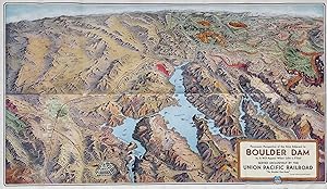
Color birds-eye map [46 cm x 78 cm]. Better than very good. Folds as issued. Map drawn by Gerald A. Eddy. Charming birds-eye map produced by the railroad to try to entice tourists to the Mojave, southern Nevada (this was before Las Vegas was "Las Vegas"), and the surrounding area, that was also served by the U.P. and the Utah Pa…rks Company, with the lodges at Bryce, Zion, Cedar Breaks. and the North Rim of the Grand Canyon located. Valley of Fire and Buried City are also located. The reverse contains information on the Dam and area, including descriptions of the location, the hydroelectric capabilities, Boulder City, Las Vegas and recreational suggestions. "Down in the rock-walled recesses of the Black Canyon of the Colorado River, an army of men and a vast array of titan machinery are busily engaged in the construction of one of the greatest engineering project of its kind the world has ever known - Boulder Dam.".
 Más imágenes
Editorial: Union Pacific System, [Omaha, NE] 1935
Librería: Carpe Diem Fine Books, ABAA, Monterey, CA, Estados Unidos de AmericaCarpe Diem Fine Books, ABAA
Contactar con el vendedorVendedor de 5 estrellasCondición: Usado
EUR 142,86
Envío por EUR 4,35Se envía dentro de Estados Unidos de AmericaCantidad disponible: 1 disponibles
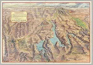
Color birds-eye perspective map drawn by Gerald A. Eddy (46 x 78 cm), folded into self-wrappers. On verso: text, illustrations, and "Map of the Union Pacific System and through car lines." Printed by Poole Bros. in Chicago. A near fine copy (3 short splits at edges, not affecting the map), A colorful tourist promotional map show…ing the locations of important nationals parks, monument, lodges and cities including Bryce, Zion, Cedar Breaks, Grand Canyon, Valley of Fire, Las Vegas, Boulder City and more. The reverse side of the map includes Facts Concerning Boulder Dam, How to Visit, and information about Boulder City and Las Vegas.
 Más imágenes
Editorial: Gerald A. Eddy, Glendale, California 1942
Librería: Argosy Book Store, ABAA, ILAB, New York, NY, Estados Unidos de AmericaArgosy Book Store, ABAA, ILAB
Contactar con el vendedorVendedor de 5 estrellasCondición: Usado
EUR 167,27
Envío por EUR 5,27Se envía dentro de Estados Unidos de AmericaCantidad disponible: 1 disponibles
unbound. Map. Lithograph. 9.75 x 8.75 inches. In very good condition. Comes with original glycine printed envelope. Glendale, CA: Fold-O-Globe, (1942). Delightful three dimensional folding globe. Continuous map projection showing the globe in 4 sides. Shows axis controlled areas and British territories. The design was patented b…y the artist. Gerald Allen Eddy (1889 - 1967) was from Michigan and moved to Southern California in 1902. He worked in Los Angeles as an artist and commercial cartographer.
 Más imágenes
Editorial: Glendale, CA: Gerald A. Eddy; Union Pacific Railroad, 1958 1958
- Mapa
Librería: James Arsenault & Company, ABAA, Arrowsic, ME, Estados Unidos de AmericaJames Arsenault & Company, ABAA
Contactar con el vendedorVendedor de 5 estrellasCondición: Usado
EUR 266,73
Envío por EUR 8,12Se envía dentro de Estados Unidos de AmericaCantidad disponible: 1 disponibles
Folding color process map, 22" x 31", 18 panels of illus. and text on verso, folded size 7.5" x 5.25". A striking post-WWII panoramic map of the Southwest including portions of Nevada and Arizona, as well as California's Death Valley and Utah's Zion, Bryce and Cedar Breaks areas, depicting the vast region accessible via the Unio…n Pacific Railroad, including its mountains, cliffs, washes, plateaus, mines, Hoover and other dams, Nellis Air Force Base, the Atomic Energy Commission testing grounds, Indian reservations, Valley of Fire state park, numerous national parks, forests, and monuments, the Colorado River supplying Lake Mead, and Boulder City and Las Vegas with street grids showing hotel locations. The map ranges from the Grand Canyon in the East to Death Valley and the Yucca Flats in the West; and from Boulder City in the south to Salt Lake City in the North. The Union Pacific Railroad lines are delineated in red; elevations are indicated for mountains and terrain within state and national parks; and bodies of water show depths and state boundaries. Promotional text and colorful illustrations of Las Vegas appear on the verso. An engineering marvel, Hoover Dam and Lake Mead became a tourist attraction during the post-war boom. The project opened up the west for development, providing water from the once-wild Colorado River to the arid Southwest, leading to the expansion of such major cities as Los Angeles, Las Vegas and Phoenix, as well as the growth of railroad lines, national recreational areas, and military installations. CONDITION: Good, blue ink routes discreetly traced on Rt. 95 and Rt 89.


