Importe total (1 artículo artículos):
Destino del pedido:

commercial maps (3 resultados)
Ir a los resultados principales
Filtros de búsqueda
Tipo de artículo
- Todos los tipos de productos
- Libros (3)
- Revistas y publicaciones (No hay ningún otro resultado que coincida con este filtro.)
- Cómics (No hay ningún otro resultado que coincida con este filtro.)
- Partituras (No hay ningún otro resultado que coincida con este filtro.)
- Arte, grabados y pósters (No hay ningún otro resultado que coincida con este filtro.)
- Fotografías (No hay ningún otro resultado que coincida con este filtro.)
- Mapas (No hay ningún otro resultado que coincida con este filtro.)
- Manuscritos y coleccionismo de papel (No hay ningún otro resultado que coincida con este filtro.)
Condición Más información
- Nuevo (No hay ningún otro resultado que coincida con este filtro.)
- Como nuevo, Excelente o Muy bueno (No hay ningún otro resultado que coincida con este filtro.)
- Bueno o Aceptable (1)
- Regular o Pobre (No hay ningún otro resultado que coincida con este filtro.)
- Tal como se indica (2)
Encuadernación
- Todas
- Tapa dura (1)
- Tapa blanda (No hay ningún otro resultado que coincida con este filtro.)
Más atributos
- Primera edición (No hay ningún otro resultado que coincida con este filtro.)
- Firmado (No hay ningún otro resultado que coincida con este filtro.)
- Sobrecubierta (No hay ningún otro resultado que coincida con este filtro.)
- Con imágenes (2)
- No impresión bajo demanda (3)
Idioma (1)
Precio
- Cualquier precio
- Menos de EUR 20 (No hay ningún otro resultado que coincida con este filtro.)
- EUR 20 a EUR 45 (No hay ningún otro resultado que coincida con este filtro.)
- Más de EUR 45
Gastos de envío gratis
- Envío gratis a Estados Unidos de America (No hay ningún otro resultado que coincida con este filtro.)
Ubicación del vendedor
Valoración de los vendedores
-
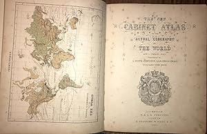
Cabinet Atlas of the Actual Geography of the World, With a Complete Index., 1867, Complete With 34 Coloured Maps
Publicado por W & A. K. Johnston, Edinburgh, 1867
Librería: Ely Books, ELY, CAMBS, Reino Unido
Calificación del vendedor: 5 de 5 estrellas

EUR 178,87
Envío por EUR 24,31
Se envía de Reino Unido a Estados Unidos de AmericaCantidad disponible: 1 disponibles
Ańadir al carritoHard Cover. With a Frontis Physical & Commercial Chart of the World Plus 33 Maps, All Coloured Ilustrador. PP: Frontis Map, (v), (i)blank, 33 Maps, 35(index), (i)Advert. Original cloth with "Atlas" in gilt to upper cover. Foxing to the first few pages; otherwise very good. Size: 31.5 X 25.5 Cms.
-

Kent Map
Publicado por London . 1708., 1708
Librería: Little Stour Books PBFA Member, Canterbury, Reino Unido
Miembro de asociación: PBFA
Calificación del vendedor: 5 de 5 estrellas
EUR 77,51
Envío por EUR 34,73
Se envía de Reino Unido a Estados Unidos de AmericaCantidad disponible: 1 disponibles
Ańadir al carritoUncoloured copper engraved map 8˝'' x 7Ľ'' inches. Commonly referred to as 'Miniature Morden's' this map was printed as part of 'Fifty Six New and Accurate Maps of Great Britain' published in conjunction with Herman Moll in 1708. Mounted on contemporary paper with a brown stain to the verso of the right hand margin of the mounting paper, (not the map), folded lines across the top and bottom margins of the map, records society label to the reverse of the map. Member of the P.B.F.A. KENT [Maps].
-

A Map of the Countries Between Constantinople and Calcutta, Including Turkey in Asia, Persia, Afghanistan, and Turkestan
Publicado por Edward Stanford
Librería: Books From California, Simi Valley, CA, Estados Unidos de America
Calificación del vendedor: 4 de 5 estrellas

EUR 372,66
Envío por EUR 4,30
Se envía dentro de Estados Unidos de AmericaCantidad disponible: 1 disponibles
Ańadir al carritoCondición: Good. This is a large folding coloured linen backed map. Map is clean with minimal wear. No copyright date is given.