Close sir charles (37 resultados)

Editorial: Geographical Journal, Ldn, 1921
- Tapa blanda
- Publicación periódica
Librería: Larry W Price Books, Portland, OR, Estados Unidos de AmericaLarry W Price Books
Contactar con el vendedorVendedor de 5 estrellasCondición: Usado - Bueno
EUR 6,22
Envío por EUR 4,33Se envía dentro de Estados Unidos de AmericaCantidad disponible: 1 disponibles
Pamphlet. Condición: Very Good. Vol 57, No 6, June, 1921, pp. 446-460, Illus, Extracted from orig vol, thus begins with title page, trimmed & stapled pamphlet, title page in facsimile else VG.

- Tapa blanda
Librería: MW Books, New York, NY, Estados Unidos de AmericaMW Books
Contactar con el vendedorVendedor de 5 estrellasCondición: Usado
EUR 24,44
Gastos de envío gratisSe envía dentro de Estados Unidos de AmericaCantidad disponible: 1 disponibles
Reprint. Very good paperback copy; edges somewhat slightly dust-dulled and nicked. Remains particularly well-preserved overall; tight, bright, clean and strong. Physical description; xxxv, 164p [14]p. of plates : ill, ports, facsims. Subjects; Great Britain. Ordnance Survey. Cartography Great Britain History. 3 Kg.

- Tapa dura
Librería: MW Books, New York, NY, Estados Unidos de AmericaMW Books
Contactar con el vendedorVendedor de 5 estrellasCondición: Usado
EUR 27,25
Gastos de envío gratisSe envía dentro de Estados Unidos de AmericaCantidad disponible: 1 disponibles
First Edition in this form. Very good cloth copy in a near-fine, very slightly edge-nicked and dust-dulled dust-wrapper, now mylar-sleeved. Remains particularly and surprisingly well-preserved overall; tight, bright, clean and strong. Physical description; xxxv,164p,16p of plates : ill., maps(1 col),ports. ; 23 cm. Subject; Grea…t Britain. Ordnance Survey History. 3 Kg.

- Tapa blanda
Librería: MW Books Ltd., Galway, IrlandaMW Books Ltd.
Contactar con el vendedorVendedor de 5 estrellasCondición: Usado
EUR 14,95
Envío por EUR 13,95Se envía de Irlanda a Estados Unidos de AmericaCantidad disponible: 1 disponibles
Reprint. Very good paperback copy; edges somewhat slightly dust-dulled and nicked. Remains particularly well-preserved overall; tight, bright, clean and strong. Physical description; xxxv, 164p [14]p. of plates : ill, ports, facsims. Subjects; Great Britain. Ordnance Survey. Cartography Great Britain History. 1 Kg.

- Tapa dura
Librería: MW Books Ltd., Galway, IrlandaMW Books Ltd.
Contactar con el vendedorVendedor de 5 estrellasCondición: Usado
EUR 18,00
Envío por EUR 13,95Se envía de Irlanda a Estados Unidos de AmericaCantidad disponible: 1 disponibles
First Edition in this form. Very good cloth copy in a near-fine, very slightly edge-nicked and dust-dulled dust-wrapper, now mylar-sleeved. Remains particularly and surprisingly well-preserved overall; tight, bright, clean and strong. Physical description; xxxv,164p,16p of plates : ill., maps(1 col),ports. ; 23 cm. Subject; Grea…t Britain. Ordnance Survey History. 1 Kg.

Idioma: Inglés
Editorial: David and Charles, Newton Abbot, 1969
- Tapa dura
Librería: Tibbycats, Maiden Newton, DORSE, Reino UnidoTibbycats
Contactar con el vendedorVendedor de 5 estrellasCondición: Usado - Muy bueno
EUR 11,43
Envío por EUR 21,13Se envía de Reino Unido a Estados Unidos de AmericaCantidad disponible: 1 disponibles
Hardcover. Condición: Near Fine. Estado de la sobrecubierta: Near Fine. Hard cover book with price clipped dust wrapper in near fine condition. This book was originally published in 1926. This is the first reprint with an introduction by Dr J B Harley, 1969.
Editorial: Ordnance Survey Office
Librería: WeBuyBooks, Rossendale, LANCS, Reino UnidoWeBuyBooks
Contactar con el vendedorVendedor de 5 estrellasCondición: Usado - Aceptable
EUR 7,96
Envío por EUR 9,16Se envía de Reino Unido a Estados Unidos de AmericaCantidad disponible: 1 disponibles
Condición: Good. Most items will be dispatched the same or the next working day. A copy that has been read but remains in clean condition. All of the pages are intact and the cover is intact and the spine may show signs of wear. The book may have minor markings which are not specifically mentioned. Dissected cloth backed map in…god order, last revision 1930. Covers quite well thumbed but with the map proper presenting well.

Idioma: Inglés
Editorial: His Majestys Stationery Office, London, 1925
- Tapa dura
Librería: Malcolm Orchard, Salisbury, Reino UnidoMalcolm Orchard
Contactar con el vendedorVendedor de 5 estrellasMiembro de asociación: PBFA
Condición: Usado - Bueno
EUR 24,05
Envío por EUR 25,51Se envía de Reino Unido a Estados Unidos de AmericaCantidad disponible: 1 disponibles
Hardcover. Condición: Very Good. 3rd Edition. Third edition, Eighteenth Thousand, 1925. 566 pages. Illustrated. Folding maps. Original cloth. Very Good.
 Más imágenes
Editorial: Chatham. Published by the Institution of Royal Engineers. 1926, 1926
- Tapa dura
Librería: J. Patrick McGahern Books Inc. (ABAC), Ottawa, ON, CanadaJ. Patrick McGahern Books Inc. (ABAC)
Contactar con el vendedorVendedor de 4 estrellasCondición: Usado
EUR 25,36
Envío por EUR 8,74Se envía de Canada a Estados Unidos de AmericaCantidad disponible: 1 disponibles
hard cover. tall 8vo, 24.5cm, 157p., frontis, 15 illustrations, dark blue cloth, gilt titles on spine & front, near fine (cmt). - A history of the Ordnance Survey between 1746 and 1846 reprinted from the "Royal Engineers Journal". The first ordnance map issued for public use by the Survey was of Kent, in 1795.

Editorial: London: Peter Davies, 1932
- Tapa dura
- Primera edición
Librería: Acanthophyllum Books, Holywell, FLINT, Reino UnidoAcanthophyllum Books
Contactar con el vendedorVendedor de 3 estrellasMiembro de asociación: PBFA
Condición: Usado - Aceptable
EUR 9,62
Envío por EUR 25,62Se envía de Reino Unido a Estados Unidos de AmericaCantidad disponible: 1 disponibles
Hard covers. Condición: Good. No Jacket. 1st edition. Slight edge wear, a touch of foxing. x, 166 pp. Weight: 1 Language: English.
Editorial: His Majesty's Stationery Office 1925 (3rd edition), 1925
- Tapa dura
Librería: Hard to Find Books NZ (Internet) Ltd., Dunedin, OTAGO, Nueva ZelandaHard to Find Books NZ (Internet) Ltd.
Contactar con el vendedorVendedor de 5 estrellasMiembro de asociación: IOBA
Condición: Usado
EUR 20,56
Envío por EUR 18,10Se envía de Nueva Zelanda a Estados Unidos de AmericaCantidad disponible: 1 disponibles
Quarto, red cloth boards with gilt lettering to spine, page edges stained mottled red, iv + 366pp, illus plus folding map in pocket at rear, VG- (moderately heavy soiling & staining to boards, fading & browning to spine, heavy browning to page edges, dampstaining to fep edges,). Boards are VG- but text block is VG.

The Early Years of the Ordnance Survey
Close, Colonel Sir Charles [A reprint with a new introduction by J. B. Harley
Editorial: Published by David & Charles Ltd., Brunel House, Newton Abbot, Devon Reprinted Edition . 1969., 1969
- Tapa dura
Librería: Little Stour Books PBFA Member, Canterbury, Reino UnidoLittle Stour Books PBFA Member
Contactar con el vendedorVendedor de 5 estrellasMiembro de asociación: PBFA
Condición: Usado - Bueno
EUR 9,62
Envío por EUR 35,02Se envía de Reino Unido a Estados Unidos de AmericaCantidad disponible: 1 disponibles
Condición: Very Good. Reprinted edition hard back binding in publisher's original tangerine cloth covered boards, blocked and lettered gilt back. 8vo. 8½'' x 6''. Contains (xxxv),164 pp with monochrome and maps and illustrations throughout. Fine condition book in Very Good condition dust wrapper with sun fading down the spine. M…ember of the P.B.F.A. CARTOGRAPHY, MAPS, PLANS.
Text Book of Topographical and Geographical Surveying (Third Edition - Eighteenth Thousand)
CLOSE, Colonel Sir CHARLES & WINTERBOTHAM, Colonel H. St. J. L. (Eds)
Editorial: His Majesty's Stationery Office 1925, 1925
- Tapa dura
Librería: Hard to Find Books NZ (Internet) Ltd., Dunedin, OTAGO, Nueva ZelandaHard to Find Books NZ (Internet) Ltd.
Contactar con el vendedorVendedor de 5 estrellasMiembro de asociación: IOBA
Condición: Usado
EUR 29,55
Envío por EUR 18,10Se envía de Nueva Zelanda a Estados Unidos de AmericaCantidad disponible: 1 disponibles
Imperial octavo, red buckram boards, gilt lettering to spine, blind rule to boards, red speckling to page edges, pocket to rear pastedown (maps NOT included), iv + 366pp, illus/plates/maps- not counted presumed all present, VG- (light bruising to extrems, heavy scuffing & staining to boards, light tanning to page edges, prev. ow…ners' names in ink to both pastedowns, occasional foxing to pgs sporadically throughout).
Editorial: Published by Colonel Sir Charles Close and Printed at the Ordnance Survey Office Southampton Revised Edition . 1919., 1919
- Tapa dura
Librería: Little Stour Books PBFA Member, Canterbury, Reino UnidoLittle Stour Books PBFA Member
Contactar con el vendedorVendedor de 5 estrellasMiembro de asociación: PBFA
Condición: Usado
EUR 18,04
Envío por EUR 35,02Se envía de Reino Unido a Estados Unidos de AmericaCantidad disponible: 1 disponibles
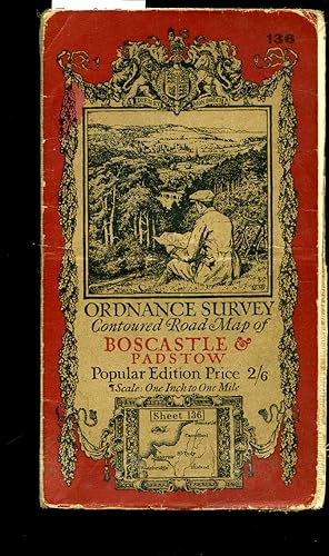
Original russet and beige paper front cover with an illustration by Ellis Martin of a man sitting on a hillside with a map and bicycle, small inset map section. This revised edition first printed in 1919 and without print code). Cloth backed paper folded 21 + 7 half section map opening to 27'' x 24''. Popular Edition Price 2/6.…One Inch to One Mile. Splits to the folded lines. Member of the P.B.F.A. CORNWALL (Kernow).

Editorial: Published by Colonel Sir Charles Close and Printed at the Ordnance Survey Office Southampton . 1938., 1938
- Tapa dura
Librería: Little Stour Books PBFA Member, Canterbury, Reino UnidoLittle Stour Books PBFA Member
Contactar con el vendedorVendedor de 5 estrellasMiembro de asociación: PBFA
Condición: Usado
EUR 18,04
Envío por EUR 35,02Se envía de Reino Unido a Estados Unidos de AmericaCantidad disponible: 1 disponibles
Original russet and beige paper front cover with an illustration by Ellis Martin of a man sitting on a hillside with a map and bicycle, small inset map section. First printed in 1925, this is a reprint from 1938 (print code 3038). Cloth backed paper folded 21 section map opening to 30'' x 21''. Popular Edition Price 2/6. One Inc…h to One Mile. Rubbing to the covers, small holes to the cross corners. Member of the P.B.F.A. YORKSHIRE (Jórvík).

Editorial: Published by Colonel Sir Charles Close and Printed at the Ordnance Survey Office Southampton . 1927., 1927
- Tapa dura
Librería: Little Stour Books PBFA Member, Canterbury, Reino UnidoLittle Stour Books PBFA Member
Contactar con el vendedorVendedor de 5 estrellasMiembro de asociación: PBFA
Condición: Usado
EUR 18,04
Envío por EUR 35,02Se envía de Reino Unido a Estados Unidos de AmericaCantidad disponible: 1 disponibles
The Half-Inch Layered series in green and beige paper front cover with open-top car and signpost illustration by Ellis Martin. First printed in 1915, this is a reprint from 1927 (print code 5000/27). Cloth backed paper folded 24 section map opening to 30'' x 21''. Three Shillings Edition ½ Inch to 1 Mile. With small slits to the… folded cross corners. Member of the P.B.F.A. YORKSHIRE (Jórvík).
 Más imágenes
Text Book Of Topographical And Geographical Surveying
Colonel Sir Charles Close and Colonel H. St. J. L. Winterbotham
Editorial: His Majestyâs Stationery Office, 1925
- Tapa dura
Librería: Hall of Books, Oswestry, SHROP, Reino UnidoHall of Books
Contactar con el vendedorVendedor de 5 estrellasCondición: Usado - Bueno
EUR 36,01
Envío por EUR 18,62Se envía de Reino Unido a Estados Unidos de AmericaCantidad disponible: 1 disponibles
Hardback. Condición: Very Good. Third edition hardback, 1925, with no jacket. In overall very good used condition with only minor signs of age, handling and storage - boards slightly rubbed with a couple of light marks. Binding tight and appears little read. Internally clean, no annotation or inscriptions - ownership signature t…o front pastedown dated 1940; text, diagrams, maps, tables and plates (some folding) bright and clear throughout. Photographs available. Not an old library book.
- Tapa blanda
Librería: Xerxes Fine and Rare Books and Documents, Glen Head, NY, Estados Unidos de AmericaXerxes Fine and Rare Books and Documents
Contactar con el vendedorVendedor de 5 estrellasCondición: Usado - Bueno
EUR 39,62
Envío por EUR 5,20Se envía dentro de Estados Unidos de AmericaCantidad disponible: 1 disponibles
Condición: VG. 1941. Article on p. 349-363, map illustrations, in single complete issue of The Geographical Journal, June 1941. Other articles in issue as well. Octavo, original blue printed wraps. VG. No ownership marks. VG.
Editorial: Published by Colonel Sir Charles Close and Printed at the Ordnance Survey Office Southampton . London 1920., 1920
- Tapa dura
Librería: Little Stour Books PBFA Member, Canterbury, Reino UnidoLittle Stour Books PBFA Member
Contactar con el vendedorVendedor de 5 estrellasMiembro de asociación: PBFA
Condición: Usado
EUR 24,05
Envío por EUR 35,02Se envía de Reino Unido a Estados Unidos de AmericaCantidad disponible: 1 disponibles
Original russet and beige paper front cover with an illustration by Ellis Martin of a man sitting on a hillside with a map and bicycle, small inset map section. Cloth backed paper folded 24 section map opening to 30'' x 21''. Popular Edition Price 2/6. One Inch to One Mile. Thin brown stain across the horizontal crease lines, no… tears. Member of the P.B.F.A. SUSSEX [Eastbourne].

Editorial: Published by Colonel Sir Charles Close and Printed at the Ordnance Survey Office Southampton . London 1921., 1921
- Tapa dura
Librería: Little Stour Books PBFA Member, Canterbury, Reino UnidoLittle Stour Books PBFA Member
Contactar con el vendedorVendedor de 5 estrellasMiembro de asociación: PBFA
Condición: Usado - Bueno
EUR 24,05
Envío por EUR 35,02Se envía de Reino Unido a Estados Unidos de AmericaCantidad disponible: 1 disponibles
Condición: Very Good. Original russet and beige paper front cover with an illustration by Ellis Martin of a man sitting on a hillside with a map and bicycle, small inset map section. Cloth backed paper folded 24 section map opening to 30'' x 21''. Popular Edition Price 2/6. One Inch to One Mile. In Very Good clean and neat condi…tion, no tears. Member of the P.B.F.A. SUSSEX [Hastings].

Editorial: Published by Colonel Sir Charles Close and Printed at the Ordnance Survey Office Southampton . London 1922., 1922
- Tapa dura
Librería: Little Stour Books PBFA Member, Canterbury, Reino UnidoLittle Stour Books PBFA Member
Contactar con el vendedorVendedor de 5 estrellasMiembro de asociación: PBFA
Condición: Usado - Bueno
EUR 24,05
Envío por EUR 35,02Se envía de Reino Unido a Estados Unidos de AmericaCantidad disponible: 1 disponibles
Condición: Very Good. Original russet and beige paper front cover with an illustration by Ellis Martin of a man sitting on a hillside with a map and bicycle, small inset map section. Cloth backed paper folded 20 section map opening to 22'' x 35''. Popular Edition Price 2/6. One Inch to One Mile. In Very Good clean and neat condi…tion, no tears. Member of the P.B.F.A. WALES & WELSH LITERATURE.

Editorial: Published by Colonel Sir Charles Close and Printed at the Ordnance Survey Office Southampton . Southampton 1919., 1919
- Tapa dura
Librería: Little Stour Books PBFA Member, Canterbury, Reino UnidoLittle Stour Books PBFA Member
Contactar con el vendedorVendedor de 5 estrellasMiembro de asociación: PBFA
Condición: Usado - Bueno
EUR 26,45
Envío por EUR 35,02Se envía de Reino Unido a Estados Unidos de AmericaCantidad disponible: 1 disponibles
Condición: Very Good. Original russet and beige paper front cover with an illustration by Ellis Martin of a man sitting on a hillside with a map and bicycle, small inset map section. Cloth backed paper folded 24 section map opening to 24'' x 25''. Popular Edition Price 2/6. One Inch to One Mile. In Very Good condition with light… soiling to the covers and the folded sections, no tears. Member of the P.B.F.A. DEVONSHIRE (Dumnonia).

Text book of topographical and geographical surveying / Ed. by Colonel Sir Charles Close and Colonel H. St. J. L. Winterbotham
Close, Charles Frederick Sir (1865-). Winterbotham, Harold St. John Loyd (1878-)
Editorial: London : H. M. Stationery off. [printed by Harrison and sons, ltd.], 1925
- Tapa dura
Librería: MW Books, New York, NY, Estados Unidos de AmericaMW Books
Contactar con el vendedorVendedor de 5 estrellasCondición: Usado
EUR 65,82
Gastos de envío gratisSe envía dentro de Estados Unidos de AmericaCantidad disponible: 1 disponibles
Third Edition - Eighteenth Thousand. Good copy in the original publisher's gilt-blocked and blind-bordered cloth, edges very slightly toned. Some wear and tear as with age. Corners sharp with an overall tight, bright and clean impression.Includes previous owner's inscription. Physical description; iv (i. e. vi), 336 p. incl. ill…us., tables, forms : xxx (i. e. 32) pl. (incl. maps, diagrs.) ; 27 cm. Notes; Plates (including 1 folded in pocket) are part colored and part folded. Subjects; Topographical surveying. Surveying. Genre; Illustrated. 4 Kg.

Editorial: Southampton: Colonel Sir Charles Close, 1914
- Tapa blanda
Librería: MW Books, New York, NY, Estados Unidos de AmericaMW Books
Contactar con el vendedorVendedor de 5 estrellasCondición: Usado
EUR 65,82
Gastos de envío gratisSe envía dentro de Estados Unidos de AmericaCantidad disponible: 1 disponibles
Popular Edition One-Inch Map. Near fine map in original wrappers. Some minor foxing to the edges. Remains well preserved overall; tight, bright, clean and sharp-cornered. Physical description; 1 folding map. Subjects; Luton. Ordnance survey map. Contoured Road maps. British Maps. 3 Kg.

Editorial: Published by Colonel Sir Charles Close and Printed at the Ordnance Survey Office Southampton . London 1922., 1922
- Tapa dura
Librería: Little Stour Books PBFA Member, Canterbury, Reino UnidoLittle Stour Books PBFA Member
Contactar con el vendedorVendedor de 5 estrellasMiembro de asociación: PBFA
Condición: Usado - Bueno
EUR 36,07
Envío por EUR 35,02Se envía de Reino Unido a Estados Unidos de AmericaCantidad disponible: 1 disponibles
Condición: Very Good. Original russet and beige paper front cover with an illustration by Ellis Martin of a man sitting on a hillside with a map and bicycle, small inset map section. Cloth backed paper folded 36 section map opening to 38'' x 26''. Popular Edition Price 2/6. One Inch to One Mile. In Very Good clean and neat condi…tion, no tears. Member of the P.B.F.A. WALES & WELSH LITERATURE.

Text book of topographical and geographical surveying / Ed. by Colonel Sir Charles Close and Colonel H. St. J. L. Winterbotham
Close, Charles Frederick Sir (1865-). Winterbotham, Harold St. John Loyd (1878-)
Editorial: London : H. M. Stationery off. [printed by Harrison and sons, ltd.], 1925
- Tapa dura
Librería: MW Books Ltd., Galway, IrlandaMW Books Ltd.
Contactar con el vendedorVendedor de 5 estrellasCondición: Usado
EUR 60,00
Envío por EUR 13,95Se envía de Irlanda a Estados Unidos de AmericaCantidad disponible: 1 disponibles
Third Edition - Eighteenth Thousand. Good copy in the original publisher's gilt-blocked and blind-bordered cloth, edges very slightly toned. Some wear and tear as with age. Corners sharp with an overall tight, bright and clean impression.Includes previous owner's inscription. Physical description; iv (i. e. vi), 336 p. incl. ill…us., tables, forms : xxx (i. e. 32) pl. (incl. maps, diagrs.) ; 27 cm. Notes; Plates (including 1 folded in pocket) are part colored and part folded. Subjects; Topographical surveying. Surveying. Genre; Illustrated. 2 Kg.

Editorial: Southampton: Colonel Sir Charles Close, 1914
- Tapa blanda
Librería: MW Books Ltd., Galway, IrlandaMW Books Ltd.
Contactar con el vendedorVendedor de 5 estrellasCondición: Usado
EUR 60,00
Envío por EUR 13,95Se envía de Irlanda a Estados Unidos de AmericaCantidad disponible: 1 disponibles
Popular Edition One-Inch Map. Near fine map in original wrappers. Some minor foxing to the edges. Remains well preserved overall; tight, bright, clean and sharp-cornered. Physical description; 1 folding map. Subjects; Luton. Ordnance survey map. Contoured Road maps. British Maps. 1 Kg.
Editorial: Augustus M. Kelley, 1969
- Tapa dura
Librería: Yushodo Co., Ltd., Fuefuki-shi, Yamanashi Pref., JaponYushodo Co., Ltd.
Contactar con el vendedorVendedor de 5 estrellasMiembro de asociación: ILAB
Condición: Usado - Aceptable
EUR 48,44
Envío por EUR 30,60Se envía de Japon a Estados Unidos de AmericaCantidad disponible: 1 disponibles
Hardcover. Condición: Good. xxxv, 164pp. Cloth.
Librería: Oast Park Books, Southend -on- Sea, ESSEX, Reino UnidoOast Park Books
Contactar con el vendedorVendedor de 5 estrellasCondición: Usado
EUR 26,45
Envío por EUR 23,35Se envía de Reino Unido a Estados Unidos de AmericaCantidad disponible: 1 disponibles
1969. David and Charles Reprints. Hardback. Book - Fair, ex-lib, a little shaken.

Idioma: Inglés
- Tapa dura
- Impresión bajo demanda
Librería: S N Books World, Delhi, IndiaS N Books World
Contactar con el vendedorVendedor de 5 estrellasCondición: Nuevo
EUR 28,80
Gastos de envío gratisSe envía de India a Estados Unidos de AmericaCantidad disponible: 18 disponibles
LeatherBound. Condición: NEW. BOOKS ARE EXEMPT FROM IMPORT DUTIES AND TARIFFS; NO EXTRA CHARGES APPLY. Leatherbound edition. Condition: New. Leather Binding on Spine and Corners with Golden leaf printing on spine. Bound in genuine leather with Satin ribbon page markers and Spine with raised gilt bands. Pages: 378. A perfect gift… for your loved ones. Reprinted from 1905 edition. NO changes have been made to the original text. This is NOT a retyped or an ocr'd reprint. Illustrations, Index, if any, are included in black and white. Each page is checked manually before printing. As this print on demand book is reprinted from a very old book, there could be some missing or flawed pages, but we always try to make the book as complete as possible. Fold-outs, if any, are not part of the book. If the original book was published in multiple volumes then this reprint is of only one volume, not the whole set. IF YOU WISH TO ORDER PARTICULAR VOLUME OR ALL THE VOLUMES YOU CAN CONTACT US. Resized as per current standards. Sewing binding for longer life, where the book block is actually sewn (smythe sewn/section sewn) with thread before binding which results in a more durable type of binding. Language: English Pages: 378.


