
Importe total (1 artículo artículos):
Destino del pedido:

charles monin (31 resultados)
Ir a los resultados principales
Filtros de búsqueda
Tipo de artículo
- Todos los tipos de productos
- Libros (19)
- Revistas y publicaciones (1)
- Cómics (No hay ningún otro resultado que coincida con este filtro.)
- Partituras (No hay ningún otro resultado que coincida con este filtro.)
- Arte, grabados y pósters (6)
- Fotografías (No hay ningún otro resultado que coincida con este filtro.)
- Mapas (5)
- Manuscritos y coleccionismo de papel (No hay ningún otro resultado que coincida con este filtro.)
Condición Más información
- Nuevo (8)
- Como nuevo, Excelente o Muy bueno (2)
- Bueno o Aceptable (13)
- Regular o Pobre (No hay ningún otro resultado que coincida con este filtro.)
- Tal como se indica (8)
Encuadernación
Más atributos
- Primera edición (1)
- Firmado (1)
- Sobrecubierta (No hay ningún otro resultado que coincida con este filtro.)
- Con imágenes (26)
- No impresión bajo demanda (23)
Idioma (2)
Gastos de envío gratis
Ubicación del vendedor
Valoración de los vendedores
-
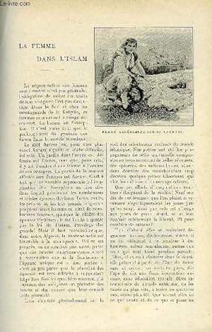
LE MONDE MODERNE TOME 10 - LA FEMME DANS L'ISLAM + LE TABLIER ROSE + HYGIENE ET MEDECINE DES GENS NERVEUX
Publicado por ALBERT QUANTIN SEPTEMBRE 1899, 1899
Librería: Le-Livre, SABLONS, Francia
Miembro de asociación: ILAB
Calificación del vendedor: 5 de 5 estrellas

Revista / Publicación
EUR 35,80
Envío por EUR 42,00
Se envía de Francia a Estados Unidos de AmericaCantidad disponible: 1 disponibles
Ańadir al carritoCouverture souple. Condición: bon. R110037100: SEPTEMBRE 1899. In-12. Broché. Bon état, Livré sans Couverture, Dos satisfaisant, Intérieur frais. Paginé de 335 ŕ 352. Quelques illustrations en noir et blanc dans le texte. 3 photos disponibles. . . . Classification Dewey : 70.49-Presse illustrée, magazines, revues.
-

STEPHANE JAY - Gantier, maire de Grenoble, chatelain d'Uriage
Publicado por Editions Ciric, 2011,, 2011
Librería: LE BOUQUINISTE, LA MOTTE SAINT MARTIN, Francia
Calificación del vendedor: 5 de 5 estrellas
EUR 14,00
Envío por EUR 43,00
Se envía de Francia a Estados Unidos de AmericaCantidad disponible: 1 disponibles
Ańadir al carritoRelié + jaquette, in-4, 395 pages, trčs bon état du livre, bon état de la jaquette, (poids : 1,500 kg, épaisseur : 3, 1 cm).
-

Les Artagnan en Bourgogne.
Idioma: Francés
Publicado por Association d'Artagnan, 1998, 1998
ISBN 10: 295132930X ISBN 13: 9782951329300
Librería: Books+, Saint Maurice, Francia
Calificación del vendedor: 5 de 5 estrellas
Ejemplar firmado
EUR 100,00
Envío por EUR 9,00
Se envía de Francia a Estados Unidos de AmericaCantidad disponible: 1 disponibles
Ańadir al carritoIn-8, 97pp., illustr., 10 planches en couleurs et documents en fac-simile, hommage autographe de l'auteur, Nb-0305,
-
Petit Atlas National des Departements de la France et de ses colonies. 100 cartes ornees de vues des monuments les plus remarquables dressees par V. Monin gravees sur acier par Ales
Publicado por Binet., Paris., 1835
Librería: Zephyr Books LLC, Reno, NV, Estados Unidos de America
Miembro de asociación: ABAA ILAB IOBA
Calificación del vendedor: 5 de 5 estrellas
EUR 97,26
Envío por EUR 5,54
Se envía dentro de Estados Unidos de AmericaCantidad disponible: 1 disponibles
Ańadir al carritoFrench text. Steel engraved maps of the 86 departments of France, 7 colonial maps, one planisphere, 3 Paris maps, 2 general maps of France and one large folding maps of France. Outline color on the folding maps, others uncolored. This will be a nice addition to the collection of anyone interested in historical maps from the 1800s. weight: 2.5 lb. Good, covers worn, pages slightly rippled, old repairs to folding map made with tape that has browned, front inner hinge split. Engraved title page, 99 full-page maps, one folding map. 24.5x32x2 cm. [4] pages plus maps. 4to. Hardcover. Old quarter brown leather over marbled boards, gilt spine decorations, paper label on cover.
-
ATLAS DE GEOGRAPHIE ANCIENNE ET MODERNE.
Idioma: Francés
Publicado por Garnier Freres, Paris, 1852
Librería: Terra Firma Books, San Diego, CA, Estados Unidos de America
Calificación del vendedor: 5 de 5 estrellas
EUR 175,96
Envío por EUR 5,14
Se envía dentro de Estados Unidos de AmericaCantidad disponible: 1 disponibles
Ańadir al carritoHardcover. Condición: Good. Atlas calls for 42 maps (missing 2: Mappemonde and Etats-Unis). Finely engraved maps with local scenes; color outlined. No name or writing.
-
![Imagen del vendedor de Perou et Bolivia ou haut Pérou [Mapa de Perú y Bolivia] a la venta por Bolivar Old Prints Anticuario](https://pictures.abebooks.com/inventory/md/md32181219886.jpg)
Perou et Bolivia ou haut Pérou [Mapa de Perú y Bolivia]
Publicado por Paris, 1835
Librería: Bolivar Old Prints Anticuario, Barcelona, B, Espańa
Miembro de asociación: AILA ILAB
Calificación del vendedor: 5 de 5 estrellas
Mapa
EUR 95,00
Envío por EUR 25,00
Se envía de Espańa a Estados Unidos de AmericaCantidad disponible: 1 disponibles
Ańadir al carritoCondición: Bueno. Elegante mapa de Perú y Bolivia de 1835. Dicho mapa se extiende desde la frontera al norte entre Perú y el actual país de Ecuador hasta la frontera sur entre Bolivia, Argentina y Chile. Este se publicó en Paris en el ańo 1835 por Charles Monin quien fue un cartógrafo francés activo en la primera mitad del siglo XIX, conocido por la publicación de mapas y atlas geográficos detallados. Su obra se centró en la representación precisa de territorios europeos y americanos, destacando por su claridad y estética. Colaboró con otros cartógrafos de la época y sus mapas fueron utilizados tanto para la educación como para la planificación estratégica. A lo largo del mapa podremos observar diversas ciudades importantes como Trujillo, Tarma, Huancavelica, Lima, Huamanga, Ilo, Arica, Cuzco, La Paz, Cochabamba, Potosí, La Plata o Chuquisaca (Antiguo nombre de Sucre), Santa Cruz de la Sierra y Tarija entre otros. Además, el autor hace uso de sombreado para definir el paisaje natural del territorio, cosa que nos ayuda a destacar y ver rápidamente figuras importantes como la Cordillera de Los Andes o el Lago Titicaca. El título se encuentra en la parte inferior izquierda y se presenta de manera muy elegante por una cartela redonda y clara. Por otra parte, en el lado derecho vemos la escala en diferentes leguas y millas. Condición Muy buena. Perou et Bolivia ou haut Pérou. Palabras clave: "Perú", "Bolivia", "Lima", "Cochabamba", "Trujillo", "Cuzco", "Potosí", "La Paz". Idioma: Francés.
-

Monde Conne Des Anciens,
Publicado por Paris, 1844
Librería: Roz Hulse, Plymouth, DEVON, Reino Unido
Calificación del vendedor: 5 de 5 estrellas
Mapa
EUR 35,68
Envío por EUR 40,42
Se envía de Reino Unido a Estados Unidos de AmericaCantidad disponible: 1 disponibles
Ańadir al carritoNo Binding. Condición: Very Good. Monin, Charles : Monde Conne Des Anciens. ca.1844. Paris. Size approx 230mm x 300mm. Hand coloured map with decorative border showing most of Europe, North Africa, Middle East, India and West Asia. Clean and bright with scales.
-
![Imagen del vendedor de La Gaule Divisee en dix sept provinces.[France], a la venta por Roz Hulse](https://pictures.abebooks.com/inventory/md/md436306972.jpg)
La Gaule Divisee en dix sept provinces.[France],
Publicado por Paris, 1844
Librería: Roz Hulse, Plymouth, DEVON, Reino Unido
Calificación del vendedor: 5 de 5 estrellas
Mapa
EUR 35,68
Envío por EUR 40,42
Se envía de Reino Unido a Estados Unidos de AmericaCantidad disponible: 1 disponibles
Ańadir al carritoNo Binding. Condición: Very Good. Monin, Charles : La Gaule Divisee en dix sept provinces. ca.1844. Paris. Size approx 230mm x 300mm. Hand coloured map with decorative border and scales. Bright and clean.
-
Atlas national contenant la géographie physique, politique, historique, théorique, économique, militaire, agricole, industrielle et commerciale de la France et de ses colonies et la statistique la plus récente et la plus complčte. Le texte par F. de la Brugčre,. et Jules Trousset,.
Publicado por Paris, Arthčme Fayard, Paris, 1877
Librería: Librairie de l'Avenue - Henri Veyrier, Saint-Ouen, FR, Francia
Calificación del vendedor: 4 de 5 estrellas

EUR 112,00
Envío por EUR 35,00
Se envía de Francia a Estados Unidos de AmericaCantidad disponible: 1 disponibles
Ańadir al carritoCouverture rigide. Condición: Bon état. Grand in-4 32,5 x 24,5 cm. Reliure toile noire, pičce de titre chagrin rouge, 504 pp., contenant en plus 111 cartes géographiques gravées sur acier dressées par Vuillemin, Lacoste, Monin ; gravées par Ales, Sorsignol, Lacouchy, sous la direction de F. de la Brugčre, 1 carte des environs de Paris repliée, table des matičres. Manquent la page de titre, la carte des constellations visibles en France et la grande carte générale de France 1 m. 30 sur 1 mčtre.
-
Voyage Du Jeune Anacharsis En Grece. Atlas
Publicado por Abel Ledoux Fils, 1830
Librería: Sequitur Books, Boonsboro, MD, Estados Unidos de America
Miembro de asociación: IOBA
Calificación del vendedor: 5 de 5 estrellas
EUR 172,42
Envío por EUR 4,27
Se envía dentro de Estados Unidos de AmericaCantidad disponible: 1 disponibles
Ańadir al carritoHardcover. Condición: Good. Atlas volume for Barthelemy's Voyage Du Jeune Anacharsis En Grece. Oblong 4to. Dessine par Charles Monin et grave par les freres Malo. 43 plates. Near fine binding and cover. Leather spine over later marbled boards. Color fold out map. Plates generally clean, and unmarked. Old browning/dampstain to top margin, doesn't effect plates.
-
Atlas Classique de la Geographie Ancienne, du Moyen Age, et Moderne, a l'Usage des Colleges et des Pensions
Publicado por Perise Freres., Lyon., 1836
Librería: Zephyr Books LLC, Reno, NV, Estados Unidos de America
Miembro de asociación: ABAA ILAB IOBA
Calificación del vendedor: 5 de 5 estrellas
EUR 238,30
Envío por EUR 5,54
Se envía dentro de Estados Unidos de AmericaCantidad disponible: 1 disponibles
Ańadir al carritoFrench text. A nicely bound copy with Monin's attractive lithographed maps. Includes the North American map with the United States border extending to the Pacific Ocean. and Mexican California and Texas. The Sacramento River flows westward from Lake Timpanogos. Bookplate of F. Calumeau to pastedown. weight: 2.1 lb. Very good, corners and spine ends worn, boards scuffed, bookplate to pastedown, scattered foxing and spotting. 36 double-page maps, 34 with outline color. 32.8x23.5x2 cm. [4] pages plus maps. Folio. Hardcover. Contemporary quarter green leather over green marbled boards, gilt spine title.
-
Carte Roy.me de Sardaigne; Atlas universel de geographie ancienne et moderne
Publicado por Paris, Bernard - Binet 1837 -1840, Paris, 1837
Librería: Messinissa libri, Milano, MI, Italia
Calificación del vendedor: 3 de 5 estrellas

EUR 262,50
Envío por EUR 41,00
Se envía de Italia a Estados Unidos de AmericaCantidad disponible: 1 disponibles
Ańadir al carritohardcover. Condición: Molto buono (Very Good). 1837-1840. Mezza legatura con copertina rigida marmorizzata con titoli e fregi solo al dorso in oro. 41 p.; Ill.; 26x33 cm. Leggeri segni del tempo come da foto ed efflorescenze varie.BZ .
-
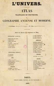
L'Univers. Atlas classique et universel de géographie ancienne et moderne. First edition
Publicado por Paris: Armand Aubrée, 1837
Librería: Wittenborn Art Books, San Francisco, CA, Estados Unidos de America
Calificación del vendedor: 5 de 5 estrellas
Arte / Grabado / Póster
EUR 1.061,04
Envío por EUR 8,58
Se envía dentro de Estados Unidos de AmericaCantidad disponible: 1 disponibles
Ańadir al carritoCondición: Good. Large folio. Contemporary qtr. roan and marbled boards, worn. 57 x 40 cm. 37 of 38 double page maps. Includes 9 of the Americas. Light foxing throughout. Uncolored.Introduction by A. Montémont, author of Bibliothčque universelle des voyages from which maps no. 1-3 are taken.OCLC Number:2791319Notes by David Rumsey to his copy:"Accompanies Montemont's Histoire Universellle Des Voyages. Large Folio atlas. Not in Phillips. 1st page of ancient maps lacking. We can find no record of this atlas, other than the Sabin reference and the Oceanie map in Tooley Aust. Monin and Fremin did a smaller world atlas, offered by Hudson in 1988. These maps are large and impressive. They were published with Montemont's 46 volume History of Voyages, although Sabin calls for an Atlas of 22 maps, whereas this has 38 maps on 36 sheets. Maps are without color and bound in quarter leather brown marbled paper covered boards with "Atlas De L'Histoire Des Voyages" stamped in gold on the spine."Géographie ancienne 8 cartes en 4 pages.Géographie moderne Planisphčre sur double page, Mappemonde sur double page. Asie:5 cartes Carte générale sur double page, Chine, Japon in plano sur double page.Asie Méridionale,l'Inde 1 page,Turquie d'Asie sur 1 page.Asie Boréale sur 1 page. Afrique 5 cartes :Afrique carte générale in plano sur double page.Asie septentrionale Alger,Maroc Tunisie Tripoli?1 page, Afrique méridionale 1 page,Afrique orientale 1 page, Afrique occidentale 1 page.Amérique 9 cartes : Amérique méridionale in plano sur double page,Amérique septentrionale in plano sur double page, Mexique et Guatemala 1 page, Etats-Unis et Canada 1 page,Colombie et Guyane 1 page,Pérou et Bolivie 1 page,La plata et le Chili 1 page,Brésil,Paraguay et Uruguay 1 page,Amérique Boréale 1 page.Europe in plano sur double page,Sučde,Norvčge et Danemark 1 page,Iles Britanniques 1 page,Espagne et Portugal 1 page,Turquie Orientale 1 page,Turquie d'Europe et Grčce 1 page.Italie,Suisse et Tyrol. In-folio ˝ basane havane ép. 37 (sur 38) cartes gravées sur double page, ŕ pleine page ou 2 par page. Manque la carte "Alger, Maroc, Tunis, Tripoli, etc.". Frottés et épidermures.
-
[PICTORIAL 'GASTRONOMIC MAP' OF FRANCE]
Idioma: Francés
Publicado por Chez Troude [.] Passage Valois, Paris, 1830
Librería: Boris Jardine Rare Books, Edinburgh, Reino Unido
Calificación del vendedor: 5 de 5 estrellas
Mapa Original o primera edición
EUR 2.973,46
Envío por EUR 20,73
Se envía de Reino Unido a Estados Unidos de AmericaCantidad disponible: 1 disponibles
Ańadir al carritoCondición: Very Good. 1st Edition. Folding engraved map (536 x 753mm), dissected and mounted on linen, showing France, part of Spain, Italy, Switzerland, the German Lands, Belgium, and Southern England, Corsica inset to bottom right, the region around Paris to the bottom left, table headed 'Division Administrative' to upper right, primary and secondary postal routes indicated by black lines, regional produce indicated by 46 vignettes, cartouche to upper left, no scale given (edges worn and some grubbiness to the left-hand side of the map, closed tear affecting 3 panels, occasional evidence of double-striking in the printing); folding to octavo (189 x 121mm) in original patterned purple cloth (spine a little weak; residue to the spine and about 15mm of each cover). Provenance: Nelson Matcham (1811-1886), bookplate to inside cover (Matcham, a barrister, was Admiral Lord Nelson's nephew). A rare and ingenious pictorial map of France, showing the main gastronomic products of each region, illustrated by some 46 vignettes. The map is known in only two other copies, both at the Bibliothčque nationale de France, one identical to the present copy (though not dissected, and with subtle hand-colouring), the other with an amended cartouche in which the publisher is omitted and the date 1838 added. The clarity of the vignettes allows an easy understanding of the distribution of produce across the country, with the wine barrels particularly distinct. The map also rewards close study - it is easy to pick out, for example, regions specialising in fungi, olives, anchovies, and honey. Many if not all of the 'data' presented still hold true to the present day. Although an attractive and fascinating map, this can also be seen as a political project - providing a visual argument both for national unity around the economic productivity of the whole country, and the preservation of regional particularity in different food staples (not to mention an argument for the extraordinary gastronomic riches of the country, and the relative paucity of produce around the nation's capital). This is the first state of the map, and is dated to 1830 by a contemporary advertisement in the journal Bibliographie de la France (for 2 January 1830), where the engraver is listed as 'Hocquart', presumably Édouard Hocquart (1789-1870). Monin was an innovative cartographer, who elsewhere made use of the new technique of lithographic printing, produced three important atlases and was a member of the Société de Géographie. There is some confusion over his dates: he is sometimes said to have been born around the time this map was published; further research is clearly needed into his life and output. This is certainly one of his earliest productions. References: Bibliothčque nationale de France, département Cartes et plans, GE C-6607 / GE C-1774.
-
![Imagen del vendedor de Dictionnaire historique, moral et religieux, et description geographique, biographique, statistique et postale, complete de toutes les Villes, Bourgs, Communes et Hameaux du departement de la seine-inferieure. 1846 [LeatherBound] a la venta por S N Books World](https://pictures.abebooks.com/inventory/md/md30877618022.jpg)
Dictionnaire historique, moral et religieux, et description geographique, biographique, statistique et postale, complete de toutes les Villes, Bourgs, Communes et Hameaux du departement de la seine-inferieure. 1846 [LeatherBound]
Idioma: Francés
Ańo de publicación: 2025
Librería: S N Books World, Delhi, India
Calificación del vendedor: 5 de 5 estrellas
EUR 27,40
Gastos de envío gratis
Se envía de India a Estados Unidos de AmericaCantidad disponible: 18 disponibles
Ańadir al carritoLeatherBound. Condición: NEW. BOOKS ARE EXEMPT FROM IMPORT DUTIES AND TARIFFS; NO EXTRA CHARGES APPLY. Leatherbound edition. Condition: New. Leather Binding on Spine and Corners with Golden leaf printing on spine. Bound in genuine leather with Satin ribbon page markers and Spine with raised gilt bands. Pages: 258. A perfect gift for your loved ones. Reprinted from 1846 edition. NO changes have been made to the original text. This is NOT a retyped or an ocr'd reprint. Illustrations, Index, if any, are included in black and white. Each page is checked manually before printing. As this print on demand book is reprinted from a very old book, there could be some missing or flawed pages, but we always try to make the book as complete as possible. Fold-outs, if any, are not part of the book. If the original book was published in multiple volumes then this reprint is of only one volume, not the whole set. IF YOU WISH TO ORDER PARTICULAR VOLUME OR ALL THE VOLUMES YOU CAN CONTACT US. Resized as per current standards. Sewing binding for longer life, where the book block is actually sewn (smythe sewn/section sewn) with thread before binding which results in a more durable type of binding. Language: French Pages: 258.
-
![Imagen del vendedor de Dictionnaire historique, moral et religieux, et description geographique, biographique, statistique et postale, complete de toutes les villes, bourgs, communes et hameaux du departement de la Seine-Inferieure; ouvrage orne de cinq cartes dresses sur une grande echelle, d'apres celles du depot de la guerre 1844 [LeatherBound] a la venta por S N Books World](https://pictures.abebooks.com/inventory/md/md30637963308.jpg)
Dictionnaire historique, moral et religieux, et description geographique, biographique, statistique et postale, complete de toutes les villes, bourgs, communes et hameaux du departement de la Seine-Inferieure; ouvrage orne de cinq cartes dresses sur une grande echelle, d'apres celles du depot de la guerre 1844 [LeatherBound]
Idioma: Francés
Ańo de publicación: 2025
Librería: S N Books World, Delhi, India
Calificación del vendedor: 5 de 5 estrellas
EUR 27,40
Gastos de envío gratis
Se envía de India a Estados Unidos de AmericaCantidad disponible: 18 disponibles
Ańadir al carritoLeatherbound. Condición: NEW. BOOKS ARE EXEMPT FROM IMPORT DUTIES AND TARIFFS; NO EXTRA CHARGES APPLY. Leatherbound edition. Condition: New. Leather Binding on Spine and Corners with Golden leaf printing on spine. Bound in genuine leather with Satin ribbon page markers and Spine with raised gilt bands. Pages: 254. A perfect gift for your loved ones. Reprinted from 1844 edition. NO changes have been made to the original text. This is NOT a retyped or an ocr'd reprint. Illustrations, Index, if any, are included in black and white. Each page is checked manually before printing. As this print on demand book is reprinted from a very old book, there could be some missing or flawed pages, but we always try to make the book as complete as possible. Fold-outs, if any, are not part of the book. If the original book was published in multiple volumes then this reprint is of only one volume, not the whole set. IF YOU WISH TO ORDER PARTICULAR VOLUME OR ALL THE VOLUMES YOU CAN CONTACT US. Resized as per current standards. Sewing binding for longer life, where the book block is actually sewn (smythe sewn/section sewn) with thread before binding which results in a more durable type of binding. Language: French Pages: 254.
-

Dictionnaire Historique
Librería: Majestic Books, Hounslow, Reino Unido
Calificación del vendedor: 4 de 5 estrellas
EUR 29,87
Envío por EUR 7,51
Se envía de Reino Unido a Estados Unidos de AmericaCantidad disponible: 4 disponibles
Ańadir al carritoCondición: New. Print on Demand pp. 248.
-
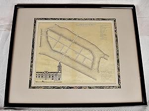
9e arrondissement, n. 33, quartier de l'Ile Saint Louis (Petit atlas pittoresque des 48 quartiers de la ville de Paris) (Original Framed Map)
Publicado por Paris : E. Garnot, 1834
Librería: Sequitur Books, Boonsboro, MD, Estados Unidos de America
Miembro de asociación: IOBA
Calificación del vendedor: 5 de 5 estrellas
Mapa
EUR 159,16
Envío por EUR 4,27
Se envía dentro de Estados Unidos de AmericaCantidad disponible: 1 disponibles
Ańadir al carritoMaps. Condición: Very Good. Framed map of Ile Saint-Louis, Paris. Mounted, under glass. Map dimensions: 12 x 10 inches. Frame dimensions: 20 1/2 x 16 1/2 inches. See: Portail des bibliotheques specialisees de la Ville de Paris.
-

Siege de Tarragone
Publicado por Paris, 1844
Librería: Frame, Madrid, M, Espańa
Calificación del vendedor: 5 de 5 estrellas
Arte / Grabado / Póster
EUR 115,00
Envío por EUR 50,00
Se envía de Espańa a Estados Unidos de AmericaCantidad disponible: 1 disponibles
Ańadir al carritoCondición: ACEPTABLE. Atlas Classique, 1844/45 Dressé par Monin Gravé par Laguillermie et Ramboz Formato (cm): 17x12.
-

Siege de Tortose (Tortosa)
Publicado por Paris, 1844
Librería: Frame, Madrid, M, Espańa
Calificación del vendedor: 5 de 5 estrellas
Arte / Grabado / Póster
EUR 115,00
Envío por EUR 50,00
Se envía de Espańa a Estados Unidos de AmericaCantidad disponible: 1 disponibles
Ańadir al carritoCondición: ACEPTABLE. Atlas Classique, 1844/45 Dressé par Monin Gravé par Laguillermie et Ramboz Formato (cm): 14x10.
-

Bataille de Vitoria le 21 Juin 1813
Publicado por Paris, 1844
Librería: Frame, Madrid, M, Espańa
Calificación del vendedor: 5 de 5 estrellas
Arte / Grabado / Póster
EUR 115,00
Envío por EUR 50,00
Se envía de Espańa a Estados Unidos de AmericaCantidad disponible: 1 disponibles
Ańadir al carritoCondición: ACEPTABLE. Atlas Classique, 1844/45 Dressé par J. Rousseau Gravé par Laguillermie et Ramboz Formato (cm): 17x12.
-

Espagne Ancienne ou Ibérie
Publicado por Paris, 1837
Librería: Frame, Madrid, M, Espańa
Calificación del vendedor: 5 de 5 estrellas
Arte / Grabado / Póster
EUR 130,00
Envío por EUR 50,00
Se envía de Espańa a Estados Unidos de AmericaCantidad disponible: 1 disponibles
Ańadir al carritoCondición: ACEPTABLE. Atlas Classique De La Geographie Ancienne, Du Moyen Age Et Moderne, A lUsage des Colleges et des Pensions, Pour Servir A LEtude De La Geographie Et De LHistoire, Par V. Monin, Ingenieur-Geographe, Membre De La Societe De Geographie., 1844/45 Dressé par J. Rousseau Gravé par Laguillermie et Ramboz. Formato (cm): 29x40.
-

ATLAS CLASSIQUE DE LA GEOGRAPHIE ANCIENNE ET MODERNE
Publicado por Edition : LYON ET PARIS, PERISSE FRERES, 1836, 1836
Librería: Livres 113, BEAUTIRAN, Francia
Calificación del vendedor: 5 de 5 estrellas
EUR 155,00
Envío por EUR 29,40
Se envía de Francia a Estados Unidos de AmericaCantidad disponible: 1 disponibles
Ańadir al carritoA l' usage des Collčges et des pensions, pour servir ŕ l'étude de la géographie et de l'histoire, corrigé et augmenté - Demi-reliure cuir in folio, plats cartonnés - Cartes sur doubles pages montées sur onglets dont une dépliante, contours et frontičres rehaussés - 34 cartes présentes sur 36, manquent la carte 12, Confédération helvétique et la carte 17, Russie d'Asie - La mappemonde dépliante est présente - Reliure trčs usagée avec manques au dos, deuxičme plat cassé, premier plat détaché - Pas de rousseurs sur les planches, rares maculations, mais une auréole claire courant sur l'ouvrage, trčs pâle dans la deuxičme moitié, mordant sur les cartes - Fente 10 cm au pli de la 9e planche - L'ensemble reste plaisant (4), (140 ) pages, 34 cm, relié. Etat moyen.
-

Espagne et Portugal
Publicado por ca. 1850, Paris, 1850
Librería: Frame, Madrid, M, Espańa
Calificación del vendedor: 5 de 5 estrellas
Arte / Grabado / Póster
EUR 185,00
Envío por EUR 50,00
Se envía de Espańa a Estados Unidos de AmericaCantidad disponible: 1 disponibles
Ańadir al carritoCondición: ACEPTABLE. Atlas Classique, 1844/45 Dressé par J. Rousseau Gravé par Laguillermie et Ramboz. Formato (cm): 29x39.
-
V. PETIT ATLAS NATIONAL DES DEPARTEMENS DE LA FRANCE. . .
Publicado por Paris, 1832
Librería: John K King Used & Rare Books, Detroit, MI, Estados Unidos de America
Calificación del vendedor: 4 de 5 estrellas
EUR 457,58
Envío por EUR 4,72
Se envía dentro de Estados Unidos de AmericaCantidad disponible: 1 disponibles
Ańadir al carrito89 nicely engraved maps, each 10 x 14, loose in worn, soiled portfolio, maps with minor foxing (some lighter, some heavier), label on portfolio torn with some text missing, portfolio ties torn or fraying. 89 FULL PAGE MAPS ILLUSTRATING THE DEPARTMENTS OF FRANCE, EACH WITH A VIGNETTE (OR TWO) OF SCENERY OR BUILDINGS. Includes "La Guadeloupe," "Alger," etc. With browned, old manuscript list of maps.
-
![Imagen del vendedor de Atlas pittoresque du departement de la Seine : comprenant les 48 quartiers de la Ville de Paris, et les arondissemens ruraux de Sceaux et de St.-Denis 1836 [LeatherBound] a la venta por True World of Books](https://pictures.abebooks.com/inventory/md/md31618391429.jpg)
Atlas pittoresque du departement de la Seine : comprenant les 48 quartiers de la Ville de Paris, et les arondissemens ruraux de Sceaux et de St.-Denis 1836 [LeatherBound]
Ańo de publicación: 2025
Librería: True World of Books, Delhi, India
Calificación del vendedor: 5 de 5 estrellas
EUR 27,40
Gastos de envío gratis
Se envía de India a Estados Unidos de AmericaCantidad disponible: 18 disponibles
Ańadir al carritoLeatherBound. Condición: New. BOOKS ARE EXEMPT FROM IMPORT DUTIES AND TARIFFS; NO EXTRA CHARGES APPLY. LeatherBound edition. Condition: New. Reprinted from 1836 edition. Leather Binding on Spine and Corners with Golden leaf printing on spine. Bound in genuine leather with Satin ribbon page markers and Spine with raised gilt bands. A perfect gift for your loved ones. Pages: 282 NO changes have been made to the original text. This is NOT a retyped or an ocr'd reprint. Illustrations, Index, if any, are included in black and white. Each page is checked manually before printing. As this print on demand book is reprinted from a very old book, there could be some missing or flawed pages, but we always try to make the book as complete as possible. Fold-outs, if any, are not part of the book. If the original book was published in multiple volumes then this reprint is of only one volume, not the whole set. Sewing binding for longer life, where the book block is actually sewn (smythe sewn/section sewn) with thread before binding which results in a more durable type of binding. Pages: 282.
-
Atlas Universel de Géographie Ancienne et Moderne en 42 Cartes 1860 [Leather Bound]
Ańo de publicación: 2024
Librería: Gyan Books Pvt. Ltd., Delhi, India
Calificación del vendedor: 5 de 5 estrellas
EUR 33,69
Gastos de envío gratis
Se envía de India a Estados Unidos de AmericaCantidad disponible: Más de 20 disponibles
Ańadir al carritoLeather Bound. Condición: New. Language: French. Language: French. Presenting an Exquisite Leather-Bound Edition, expertly crafted with Original Natural Leather that gracefully adorns the spine and corners. The allure continues with Golden Leaf Printing that adds a touch of elegance, while Hand Embossing on the rounded spine lends an artistic flair. This masterpiece has been meticulously reprinted in 2024, utilizing the invaluable guidance of the original edition published many years ago in 1860. The contents of this book are presented in classic black and white. Its durability is ensured through a meticulous sewing binding technique, enhancing its longevity. Imprinted on top-tier quality paper. A team of professionals has expertly processed each page, delicately preserving its content without alteration. Due to the vintage nature of these books, every page has been manually restored for legibility. However, in certain instances, occasional blurriness, missing segments, or faint black spots might persist. We sincerely hope for your understanding of the challenges we faced with these books. Recognizing their significance for readers seeking insight into our historical treasure, we've diligently restored and reissued them. Our intention is to offer this valuable resource once again. We eagerly await your feedback, hoping that you'll find it appealing and will generously share your thoughts and recommendations. Lang: - French, Pages: - 94, Print on Demand. If it is a multi-volume set, then it is only a single volume. We are specialised in Customisation of books, if you wish to opt different color leather binding, you may contact us. This service is chargeable. Product Disclaimer: Kindly be informed that, owing to the inherent nature of leather as a natural material, minor discolorations or textural variations may be perceptible. Explore the FOLIO EDITION (12x19 Inches): Available Upon Request. 94 94.
-
Atlas Classique De La Géographie Ancienne, Du Moyen Age, Et Moderne: A l'Usage des Colléges et des Pensions, Pour Servir Ŕ L'Étude De La Géographie Et De L'Histoire 1843 [Leather Bound]
Ańo de publicación: 2024
Librería: Gyan Books Pvt. Ltd., Delhi, India
Calificación del vendedor: 5 de 5 estrellas
EUR 34,09
Gastos de envío gratis
Se envía de India a Estados Unidos de AmericaCantidad disponible: Más de 20 disponibles
Ańadir al carritoLeather Bound. Condición: New. Language: French. Language: French. Presenting an Exquisite Leather-Bound Edition, expertly crafted with Original Natural Leather that gracefully adorns the spine and corners. The allure continues with Golden Leaf Printing that adds a touch of elegance, while Hand Embossing on the rounded spine lends an artistic flair. This masterpiece has been meticulously reprinted in 2024, utilizing the invaluable guidance of the original edition published many years ago in 1843. The contents of this book are presented in classic black and white. Its durability is ensured through a meticulous sewing binding technique, enhancing its longevity. Imprinted on top-tier quality paper. A team of professionals has expertly processed each page, delicately preserving its content without alteration. Due to the vintage nature of these books, every page has been manually restored for legibility. However, in certain instances, occasional blurriness, missing segments, or faint black spots might persist. We sincerely hope for your understanding of the challenges we faced with these books. Recognizing their significance for readers seeking insight into our historical treasure, we've diligently restored and reissued them. Our intention is to offer this valuable resource once again. We eagerly await your feedback, hoping that you'll find it appealing and will generously share your thoughts and recommendations. Lang: - French, Pages: - 164, Print on Demand. If it is a multi-volume set, then it is only a single volume. We are specialised in Customisation of books, if you wish to opt different color leather binding, you may contact us. This service is chargeable. Product Disclaimer: Kindly be informed that, owing to the inherent nature of leather as a natural material, minor discolorations or textural variations may be perceptible. Explore the FOLIO EDITION (12x19 Inches): Available Upon Request. 164 164.
-
Mappe-monde 1833
Librería: Douglas Stewart Fine Books, Armadale, VIC, Australia
Miembro de asociación: ANZAAB ILAB
Calificación del vendedor: 4 de 5 estrellas
EUR 285,69
Envío por EUR 31,76
Se envía de Australia a Estados Unidos de AmericaCantidad disponible: 1 disponibles
Ańadir al carritoParis :Charles V. Monin, 1833. Engraved map, 204 x 275 mm, withhand colouring, laid on wood and dissected to form a jigsawpuzzle, original backing card and paper wrapper with title in manuscript copperplate, some scattered foxing, complete. Acharming puzzle map of the world. The maps were usuallyunbound sheets from an atlas.
-
Dictionnaire historique, moral et religieux, et description ge?ographique, biographique, statistique et postale, comple?te de toutes les villes, bourgs, communes et hameaux du de?partement de la Seine-Infe?rieure; ouvrage orne? de cinq cartes dresse?s sur une grande e?chelle, d'apre?s celles du de?pot de la guerre. 1844 [Leather Bound]
Ańo de publicación: 2024
Librería: Gyan Books Pvt. Ltd., Delhi, India
Calificación del vendedor: 5 de 5 estrellas
EUR 58,80
Gastos de envío gratis
Se envía de India a Estados Unidos de AmericaCantidad disponible: Más de 20 disponibles
Ańadir al carritoLeather Bound. Condición: New. Language: French. Language: French. Presenting an Exquisite Leather-Bound Edition, expertly crafted with Original Natural Leather that gracefully adorns the spine and corners. The allure continues with Golden Leaf Printing that adds a touch of elegance, while Hand Embossing on the rounded spine lends an artistic flair. This masterpiece has been meticulously reprinted in 2024, utilizing the invaluable guidance of the original edition published many years ago in 1844. The contents of this book are presented in classic black and white. Its durability is ensured through a meticulous sewing binding technique, enhancing its longevity. Imprinted on top-tier quality paper. A team of professionals has expertly processed each page, delicately preserving its content without alteration. Due to the vintage nature of these books, every page has been manually restored for legibility. However, in certain instances, occasional blurriness, missing segments, or faint black spots might persist. We sincerely hope for your understanding of the challenges we faced with these books. Recognizing their significance for readers seeking insight into our historical treasure, we've diligently restored and reissued them. Our intention is to offer this valuable resource once again. We eagerly await your feedback, hoping that you'll find it appealing and will generously share your thoughts and recommendations. Lang: - French, Pages: - 254, Print on Demand. If it is a multi-volume set, then it is only a single volume. We are specialised in Customisation of books, if you wish to opt different color leather binding, you may contact us. This service is chargeable. Product Disclaimer: Kindly be informed that, owing to the inherent nature of leather as a natural material, minor discolorations or textural variations may be perceptible. Explore the FOLIO EDITION (12x19 Inches): Available Upon Request. 254 254.


![Imagen del vendedor de [PICTORIAL 'GASTRONOMIC MAP' OF FRANCE] a la venta por Boris Jardine Rare Books](https://pictures.abebooks.com/inventory/md/md32371811897.jpg)
![Imagen del vendedor de Atlas Universel de Géographie Ancienne et Moderne en 42 Cartes 1860 [Leather Bound] a la venta por Gyan Books Pvt. Ltd.](https://pictures.abebooks.com/inventory/md/md31600237002.jpg)
![Imagen del vendedor de Atlas Classique De La Géographie Ancienne, Du Moyen Age, Et Moderne: A l'Usage des Colléges et des Pensions, Pour Servir Ŕ L'Étude De La Géographie Et De L'Histoire 1843 [Leather Bound] a la venta por Gyan Books Pvt. Ltd.](https://pictures.abebooks.com/inventory/md/md31600257957.jpg)

![Imagen del vendedor de Dictionnaire historique, moral et religieux, et description ge?ographique, biographique, statistique et postale, comple?te de toutes les villes, bourgs, communes et hameaux du de?partement de la Seine-Infe?rieure; ouvrage orne? de cinq cartes dresse?s sur une grande e?chelle, d'apre?s celles du de?pot de la guerre. 1844 [Leather Bound] a la venta por Gyan Books Pvt. Ltd.](https://pictures.abebooks.com/inventory/md/md30267865276.jpg)