Charles e wymond (55 resultados)

Editorial: La Salle Extension University, Chicago 1923
- Tapa dura
Librería: Amnesty Bookshop, Bristol, Bristol, Reino UnidoAmnesty Bookshop, Bristol
Contactar con el vendedorVendedor de 5 estrellasCondición: Usado - Regular
EUR 11,91
Envío por EUR 26,60Se envía de Reino Unido a Estados Unidos de AmericaCantidad disponible: 1 disponibles
Hardcover. Condición: Fair. No Jacket. In a red cloth hardcover with gilt titles to front. No dust jacket. Book of maps, many fold-out, some in colour. A 1928 Wabash Railway Employees Chicago flier of 1928 laid in. The book is in fair condition. There is minor shelf-wear to the extremities of the cover, the boards of which have…a mottled appearance. The front hinge is cracked and the webbing exposed, the front board is slack. There is a small amount of writing to the front paste down and a former owner's name to the top of the title page. The maps are generally in very good condition. There is a small tear to the centre fold of map 1, some annotations to map 2, a crease across map 7 and two minor marks to one of the end maps.
Editorial: LaSalle Extension University: Chicago 1919
- Tapa dura
Librería: John K King Used & Rare Books, Detroit, MI, Estados Unidos de AmericaJohn K King Used & Rare Books
Contactar con el vendedorVendedor de 4 estrellasCondición: Usado
EUR 51,02
Envío por EUR 4,74Se envía dentro de Estados Unidos de AmericaCantidad disponible: 1 disponibles
27 maps. 12 x 10", dark red cloth, gilt lettering on front cover, title page, index plus maps. Covers shelfworn, stained, corners and spine tips bumped and worn, inner hinges cracked, text block becoming detached at rear inner hinge, dirt soiling to front pastedown through index, maps have edge tears, tears along folds and chipp…ing along edges else good to very good condition. EX-LIBRARY- "Dept. of Traffic Management" written inside front cover. Some of the maps: "Industrial Map Of The United States", "Union Pacific System", "Grouping Of Western Trunk Line Territory", "Freight Routes In Southern Territory", "Map Of Steamship Routes Of The World.".
Idioma: Inglés
Editorial: LaSalle Extention University, Chicago 1915
- Tapa dura
Librería: Shaker Mill Books, W. Stockbridge, MA, Estados Unidos de AmericaShaker Mill Books
Contactar con el vendedorVendedor de 5 estrellasCondición: Usado - Aceptable
EUR 110,90
Envío por EUR 5,81Se envía dentro de Estados Unidos de AmericaCantidad disponible: 1 disponibles
Hardcover. Condición: Good. No Jacket. Tight binding, brick red boards with bright gilt lettering, intact, unmarked fold-out maps, many in color of railway and steamship routes. Very nice copy from 1915.
Editorial: LaSalle Extension University, Chicago 1919
- Tapa dura
Librería: Rivertown Fine Books, McGregor, IA, Estados Unidos de AmericaRivertown Fine Books
Contactar con el vendedorVendedor de 5 estrellasCondición: Usado - Bueno
EUR 57,67
Envío por EUR 5,15Se envía dentro de Estados Unidos de AmericaCantidad disponible: 1 disponibles
Hardcover. Condición: Very Good. No Jacket. Presumed 1st. Pub by LaSalle Extension University, Chicago, 1919. NOT exLib. VG+ cond. hardcover, no dj. Deep red cloth over bds w/ bright gilt lettering on front cover. P/O's brief inscription in pencil inside front cover, & ano P/O's signature in ink on TP, o/w exceptionally clean th…roughout. Page after page of large foldout maps in color & b&w. A very nice copy. Square, straight, tight, bright & clean except as noted, overall VG+ cond. Same or next day shipping. Please email any questions.
Librería: Art Source International Inc., Boulder, CO, Estados Unidos de AmericaArt Source International Inc.
Contactar con el vendedorVendedor de 5 estrellasCondición: Usado
EUR 22,18
Envío por EUR 13,78Se envía dentro de Estados Unidos de AmericaCantidad disponible: 1 disponibles
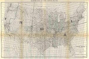
Charles E. Wymond produced this "Atlas of Traffic Maps" in 1924. The Atlas contains maps covering routes and rate classification groupings of the various transportation agencies. The United States System of Blocks and Zones for the Formulation of Express Rates is illustrated on this large very detailed map. Cities, towns, geogra…phic features, train stations, railroad lines, major roads, and localized industrial staples are also shown. An inset map of Alaska is also included on this map. This map measures 25.75 inches by 16.5 inches.
Idioma: Inglés
Editorial: Douglas Models, Chicago IL 1917
- Tapa dura
- Primera edición
Librería: T. W. Palmer Books, Eugene, OR, Estados Unidos de AmericaT. W. Palmer Books
Contactar con el vendedorVendedor de 5 estrellasCondición: Usado - Aceptable
EUR 266,15
Envío por EUR 3,45Se envía dentro de Estados Unidos de AmericaCantidad disponible: 1 disponibles
Hardcover. Condición: Good. 1st Edition. 100 year old hardbound large quarto book (29.5 x 23.5 cm page size). In original red buckram boards, sunned on spine, corners bumped and with minor abrasions. 19 large folding maps most with color, plus nine maps double page or folding, of individual systems: NY Central, B & O, UP, Santa…Fe, Pensylvania RR, Chicago Northwest, Western Maryland Railway, Chicago, Milwaukee & St. Paul, Erie RR suburban Lines. All maps as new with no signs of deterioration or mis-folding. Most have statical information included. An invaluable resource for understanding the commercial aspects of American Railroads in the first decade of the 20th century. Extremely rare.
Editorial: Lasalle Extension University 1923
- Tapa dura
Librería: Mark Henderson, Overland Park, KS, Estados Unidos de AmericaMark Henderson
Contactar con el vendedorVendedor de 4 estrellasCondición: Usado - Bueno
EUR 66,50
Envío por EUR 5,12Se envía dentro de Estados Unidos de AmericaCantidad disponible: 1 disponibles
Hardcover. Condición: Very Good. Book.
Librería: Art Source International Inc., Boulder, CO, Estados Unidos de AmericaArt Source International Inc.
Contactar con el vendedorVendedor de 5 estrellasCondición: Usado
EUR 31,05
Envío por EUR 13,78Se envía dentro de Estados Unidos de AmericaCantidad disponible: 1 disponibles
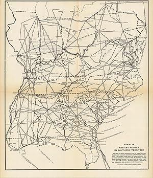
Charles E. Wymond produced this "Atlas of Traffic Maps" in 1924. The Atlas contains maps covering routes and rate classification groupings of the various transportation agencies. The Freight Routes and Junction Points in Southern Territory are illustrated on this large very detailed map. Cities, towns, geographic features, train… stations, railroad lines, major roads, and localized industrial staples are also shown. This map measures 16.5 inches by 19.5 inches.
 Más imágenes
Editorial: LaSalle Extension University, Chicago 1921
- Tapa dura
Librería: Robert Gavora, Fine & Rare Books, ABAA, Talent, OR, Estados Unidos de AmericaRobert Gavora, Fine & Rare Books, ABAA
Contactar con el vendedorVendedor de 5 estrellasCondición: Usado - Bueno
EUR 79,84
Envío por EUR 6,03Se envía dentro de Estados Unidos de AmericaCantidad disponible: 1 disponibles
Hardcover. Condición: Very good plus. A collection of fold out railroad maps which present comprehensive and accurate information concerning the freight rate territories throughout the U.S. Maps appear unused. Bound in dark red buckram with lettering in gilt. Small name stamp on the title page. A very good plus copy with cloth c…overs showing a little spotting. Book.

Librería: Art Source International Inc., Boulder, CO, Estados Unidos de AmericaArt Source International Inc.
Contactar con el vendedorVendedor de 5 estrellasCondición: Usado
EUR 35,49
Envío por EUR 13,78Se envía dentro de Estados Unidos de AmericaCantidad disponible: 2 disponibles
Charles E. Wymond produced this "Atlas of Traffic Maps" in 1924. The Atlas contains maps covering routes and rate classification groupings of the various transportation agencies. This large, very detailed map shows the percentage bases for Eastbound Rates. Cities, towns, geographic features, train stations, railroad lines, major… roads, and localized industrial staples are also shown. This map measures 17.5 inches by 16.5 inches.
Librería: Art Source International Inc., Boulder, CO, Estados Unidos de AmericaArt Source International Inc.
Contactar con el vendedorVendedor de 5 estrellasCondición: Usado
EUR 35,49
Envío por EUR 13,78Se envía dentro de Estados Unidos de AmericaCantidad disponible: 2 disponibles
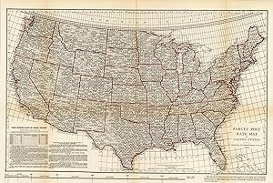
Charles E. Wymond produced this "Atlas of Traffic Maps" in 1924. The Atlas contains maps covering routes and rate classification groupings of the various transportation agencies. The Parcel Post Rate Map of the United States is illustrated on this large, very detailed map. Cities, towns, geographic features, train stations, rail…road lines, major roads, and localized industrial staples are also shown. This map measures 26.75 inches by 18.25 inches.

Librería: Art Source International Inc., Boulder, CO, Estados Unidos de AmericaArt Source International Inc.
Contactar con el vendedorVendedor de 5 estrellasCondición: Usado
EUR 35,49
Envío por EUR 13,78Se envía dentro de Estados Unidos de AmericaCantidad disponible: 2 disponibles
Charles E. Wymond produced this "Atlas of Traffic Maps" in 1924. The Atlas contains maps covering routes and rate classification groupings of the various transportation agencies. This large, very detailed map shows C.F.A. Territorial Grouping for Southbound Rates. Cities, towns, geographic features, train stations, railroad line…s, major roads, and localized industrial staples are also shown. This map measures 17.5 inches by 16.5 inches.
Librería: Art Source International Inc., Boulder, CO, Estados Unidos de AmericaArt Source International Inc.
Contactar con el vendedorVendedor de 5 estrellasCondición: Usado
EUR 35,49
Envío por EUR 13,78Se envía dentro de Estados Unidos de AmericaCantidad disponible: 2 disponibles
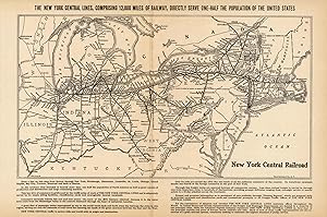
Charles E. Wymond produced this "Atlas of Traffic Maps" in 1924. The Atlas contains maps covering routes and rate classification groupings of the various transportation agencies. The New York Central Lines are illustrated on this large, very detailed map. Cities, towns, geographic features, train stations, railroad lines, major…roads, and localized industrial staples are also shown. This map measures 15.25 inches by 10.25 inches.

Librería: Art Source International Inc., Boulder, CO, Estados Unidos de AmericaArt Source International Inc.
Contactar con el vendedorVendedor de 5 estrellasCondición: Usado
EUR 35,49
Envío por EUR 13,78Se envía dentro de Estados Unidos de AmericaCantidad disponible: 2 disponibles
Charles E. Wymond produced this "Atlas of Traffic Maps" in 1924. The Atlas contains maps covering routes and rate classification groupings of the various transportation agencies. This large, very detailed map shows the Percentage Bases for Westbound Rates. Cities, towns, geographic features, train stations, railroad lines, major… roads, and localized industrial staples are also shown. This map measures 17.5 inches by 16.5 inches.
Librería: Art Source International Inc., Boulder, CO, Estados Unidos de AmericaArt Source International Inc.
Contactar con el vendedorVendedor de 5 estrellasCondición: Usado
EUR 35,49
Envío por EUR 13,78Se envía dentro de Estados Unidos de AmericaCantidad disponible: 2 disponibles
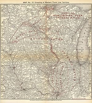
Charles E. Wymond produced this "Atlas of Traffic Maps" in 1924. The Atlas contains maps covering routes and rate classification groupings of the various transportation agencies. Grouping of Western Trunk Line Territory is illustrated on this large, very detailed map. Cities, towns, geographic features, train stations, railroad…lines, major roads, and localized industrial staples are also shown. This map measures 18.5 inches by 19.25 inches.
Librería: Art Source International Inc., Boulder, CO, Estados Unidos de AmericaArt Source International Inc.
Contactar con el vendedorVendedor de 5 estrellasCondición: Usado
EUR 35,49
Envío por EUR 13,78Se envía dentro de Estados Unidos de AmericaCantidad disponible: 1 disponibles
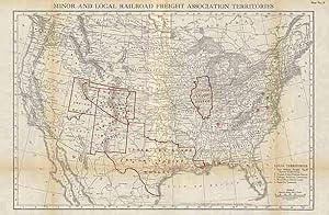
Charles E. Wymond produced this "Atlas of Traffic Maps" in 1924. The Atlas contains maps covering routes and rate classification groupings of the various transportation agencies. Minor and Local Railroad Freight Association Territories are illustrated on this large, very detailed map. Cities, towns, geographic features, train st…ations, railroad lines, major roads, and localized industrial staples are also shown. This map measures 13 inches by 18.75 inches.

Librería: Art Source International Inc., Boulder, CO, Estados Unidos de AmericaArt Source International Inc.
Contactar con el vendedorVendedor de 5 estrellasCondición: Usado
EUR 35,49
Envío por EUR 13,78Se envía dentro de Estados Unidos de AmericaCantidad disponible: 1 disponibles
Charles E. Wymond produced this "Atlas of Traffic Maps" in 1924. The Atlas contains maps covering routes and rate classification groupings of the various transportation agencies. The Western Truck Line Committee Territory is illustrated on this large, very detailed map. Cities, towns, geographic features, train stations, railroa…d lines, major roads, and localized industrial staples are also shown. This map measures 13.5 inches by 12.5 inches.
Librería: Art Source International Inc., Boulder, CO, Estados Unidos de AmericaArt Source International Inc.
Contactar con el vendedorVendedor de 5 estrellasCondición: Usado
EUR 35,49
Envío por EUR 13,78Se envía dentro de Estados Unidos de AmericaCantidad disponible: 1 disponibles
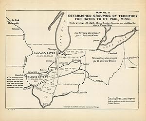
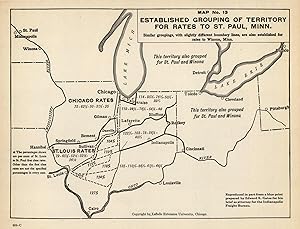
Charles E. Wymond produced this "Atlas of Traffic Maps" in 1924. The Atlas contains maps covering routes and rate classification groupings of the various transportation agencies. This map covers the grouping of territory for rates to St. Paul, Minnesota. Cities, towns, geographic features, train stations, railroad lines, major r…oads, and localized industrial staples are also shown. This map measures 10 inches by 7.5 inches.
Librería: Art Source International Inc., Boulder, CO, Estados Unidos de AmericaArt Source International Inc.
Contactar con el vendedorVendedor de 5 estrellasCondición: Usado
EUR 39,92
Envío por EUR 13,78Se envía dentro de Estados Unidos de AmericaCantidad disponible: 2 disponibles
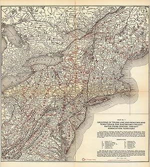
Charles E. Wymond produced this "Atlas of Traffic Maps" in 1924. The Atlas contains maps covering routes and rate classification groupings of the various transportation agencies. Grouping of Trunk Line and New England Territories for Eastbound Freight Rates are illustrated on this large, very detailed map. Cities, towns, geograp…hic features, train stations, railroad lines, major roads, and localized industrial staples are also shown. This map measures 18.25 inches by 19.25 inches.
Librería: Art Source International Inc., Boulder, CO, Estados Unidos de AmericaArt Source International Inc.
Contactar con el vendedorVendedor de 5 estrellasCondición: Usado
EUR 39,92
Envío por EUR 13,78Se envía dentro de Estados Unidos de AmericaCantidad disponible: 2 disponibles
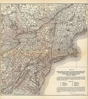
Charles E. Wymond produced this "Atlas of Traffic Maps" in 1924. The Atlas contains maps covering routes and rate classification groupings of the various transportation agencies. Grouping of Trunk Line and New England Territories and Canadian Percentage Territory for Westbound Freight Rates are illustrated on this large, very de…tailed map. Cities, towns, geographic features, train stations, railroad lines, major roads, and localized industrial staples are also shown. This map measures 18.5 inches by 20.5 inches.
Librería: Art Source International Inc., Boulder, CO, Estados Unidos de AmericaArt Source International Inc.
Contactar con el vendedorVendedor de 5 estrellasCondición: Usado
EUR 39,92
Envío por EUR 13,78Se envía dentro de Estados Unidos de AmericaCantidad disponible: 1 disponibles
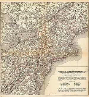
This hard to find map shows the grouping of the Trunk Line and New England Territories for Eastbound Freight Rates from Central Freight Association Territory. It was created by Charles E. Wymond for the "Atlas of Railway Traffic Maps" in 1919. The grouping of traffic territories for rate adjustments shown in this atlas is explai…ned in the treaties devoted to freight classification and rates and forming a part of the course in Interstate Commerce and Railway Traffic. This map measures 18.5 inches by 19.5 inches.
Librería: Art Source International Inc., Boulder, CO, Estados Unidos de AmericaArt Source International Inc.
Contactar con el vendedorVendedor de 5 estrellasCondición: Usado
EUR 39,92
Envío por EUR 13,78Se envía dentro de Estados Unidos de AmericaCantidad disponible: 1 disponibles
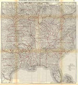
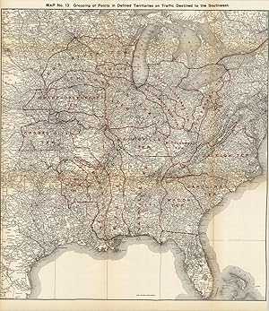
Charles E. Wymond produced this "Atlas of Traffic Maps" in 1924. The Atlas contains maps covering routes and rate classification groupings of the various transportation agencies. Territorial Groupings for traffic destined to Texas are illustrated on this large, very detailed map. Cities, towns, geographic features, train station…s, railroad lines, major roads, and localized industrial staples are also shown. This map measures 23 inches by 25.25 inches.
Librería: Art Source International Inc., Boulder, CO, Estados Unidos de AmericaArt Source International Inc.
Contactar con el vendedorVendedor de 5 estrellasCondición: Usado
EUR 39,92
Envío por EUR 13,78Se envía dentro de Estados Unidos de AmericaCantidad disponible: 1 disponibles
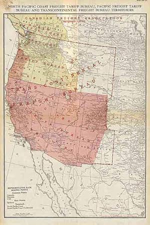
Charles E. Wymond produced this "Atlas of Traffic Maps" in 1924. The Atlas contains maps covering routes and rate classification groupings of the various transportation agencies. The North Pacific Coast Freight Tariff Bureau, Pacific Freight Tariff Bureau and Transcontinental Bureau Territories are illustrated on this large, ver…y detailed map. Cities, towns, geographic features, train stations, railroad lines, major roads, and localized industrial staples are also shown. This map measures 13 inches by 18.5 inches.
Librería: Art Source International Inc., Boulder, CO, Estados Unidos de AmericaArt Source International Inc.
Contactar con el vendedorVendedor de 5 estrellasCondición: Usado
EUR 39,92
Envío por EUR 13,78Se envía dentro de Estados Unidos de AmericaCantidad disponible: 1 disponibles
This hard to find map shows the established grouping of Territory for rates to St. Paul, Minn. It was created by Charles E. Wymond for the "Atlas of Railway Traffic Maps" in 1919. The Atlas contains maps covering routes and rate classification groupings of the various transportation agencies. The map shows rail lines stretching…across parts of the mid-west and rates. Cities, towns, train stations, and various geographic features are also shown. This map measures 10.25 inches by 7.75 inches.
Librería: Art Source International Inc., Boulder, CO, Estados Unidos de AmericaArt Source International Inc.
Contactar con el vendedorVendedor de 5 estrellasCondición: Usado
EUR 39,92
Envío por EUR 13,78Se envía dentro de Estados Unidos de AmericaCantidad disponible: 1 disponibles
Charles E. Wymond produced this "Atlas of Traffic Maps" in 1924. The Atlas contains maps covering routes and rate classification groupings of the various transportation agencies. This map focuses on the grouping points in the western half of the United States. Cities, towns, geographic features, train stations, railroad lines, m…ajor roads, and localized industrial staples are also shown. This map measures 23 inches by 25.5 inches.
 Más imágenes
Editorial: LaSalle Extension University, Chicago 1924
- Tapa dura
Librería: Charles Parkhurst Rare Books, Inc. ABAA, Surprise, AZ, Estados Unidos de AmericaCharles Parkhurst Rare Books, Inc. ABAA
Contactar con el vendedorVendedor de 5 estrellasCondición: Usado - Bueno
EUR 133,07
Envío por EUR 6,03Se envía dentro de Estados Unidos de AmericaCantidad disponible: 1 disponibles
Hard Cover. Condición: Very Good. No Jacket. Quarto; 21 color folding maps and 11 Class I railroad maps in black and white. Original green cloth, lettered in gilt. A very good copy, a few maps torn at fold.

Librería: Art Source International Inc., Boulder, CO, Estados Unidos de AmericaArt Source International Inc.
Contactar con el vendedorVendedor de 5 estrellasCondición: Usado
EUR 44,36
Envío por EUR 13,78Se envía dentro de Estados Unidos de AmericaCantidad disponible: 1 disponibles
Charles E. Wymond produced this "Atlas of Traffic Maps" in 1924. The Atlas contains maps covering routes and rate classification groupings of the various transportation agencies. Canadian (Eastern Lines), Eastern, New England, and Trunk Line Territories are illustrated on this large, very detailed map. Cities, towns, geographic…features, train stations, railroad lines, major roads, and localized industrial staples are also shown. Inset maps of the Eastern Lines and the Western Continuation are also included on the map. This map measures 13.75 inches by 10.5 inches.

Librería: Art Source International Inc., Boulder, CO, Estados Unidos de AmericaArt Source International Inc.
Contactar con el vendedorVendedor de 5 estrellasCondición: Usado
EUR 44,36
Envío por EUR 13,78Se envía dentro de Estados Unidos de AmericaCantidad disponible: 2 disponibles
Charles E. Wymond produced this "Atlas of Traffic Maps" in 1924. The Atlas contains maps covering routes and rate classification groupings of the various transportation agencies. The Southern Pacific Railroad lines and connections are illustrated on this very detailed map. Cities, towns, geographic features, train stations, rail…road lines, major roads, and localized industrial staples are also shown. This map measures 15 inches by 8 inches.

Librería: Art Source International Inc., Boulder, CO, Estados Unidos de AmericaArt Source International Inc.
Contactar con el vendedorVendedor de 5 estrellasCondición: Usado
EUR 44,36
Envío por EUR 13,78Se envía dentro de Estados Unidos de AmericaCantidad disponible: 1 disponibles
Charles E. Wymond produced this "Atlas of Traffic Maps" in 1924. The Atlas contains maps covering routes and rate classification groupings of the various transportation agencies. This large, very detailed map shows the lines operated by the Illinois Central Railroad Co., Yazoo & Mississippi Valley Railroad Co., Georgia Railway C…o., and Ocean Steamship Co. of Savannah. Cities, towns, geographic features, train stations, railroad lines, major roads, and localized industrial staples are also shown. This map measures 23.25 inches by 18 inches.

Librería: Art Source International Inc., Boulder, CO, Estados Unidos de AmericaArt Source International Inc.
Contactar con el vendedorVendedor de 5 estrellasCondición: Usado
EUR 44,36
Envío por EUR 13,78Se envía dentro de Estados Unidos de AmericaCantidad disponible: 2 disponibles
Charles E. Wymond produced this "Atlas of Traffic Maps" in 1924. The Atlas contains maps covering routes and rate classification groupings of the various transportation agencies. Grouping of Central Freight Association Territory for Eastbound Rates on Grain and Grain Products are illustrated on this large, very detailed map. Cit…ies, towns, geographic features, train stations, railroad lines, major roads, and localized industrial staples are also shown. This map measures 17 inches by 10.5 inches.


