
Importe total (1 artículo artículos):
Destino del pedido:

c b colton (177 resultados)
Ir a los resultados principales
Filtros de búsqueda
Tipo de artículo
- Todos los tipos de productos
- Libros (167)
- Revistas y publicaciones (No hay ningún otro resultado que coincida con este filtro.)
- Cómics (No hay ningún otro resultado que coincida con este filtro.)
- Partituras (No hay ningún otro resultado que coincida con este filtro.)
- Arte, grabados y pósters (No hay ningún otro resultado que coincida con este filtro.)
- Fotografías (No hay ningún otro resultado que coincida con este filtro.)
- Mapas (10)
- Manuscritos y coleccionismo de papel (No hay ningún otro resultado que coincida con este filtro.)
Condición Más información
Encuadernación
Más atributos
- Primera edición (19)
- Firmado (No hay ningún otro resultado que coincida con este filtro.)
- Sobrecubierta (3)
- Con imágenes (144)
- No impresión bajo demanda (174)
Idioma (3)
Gastos de envío gratis
Ubicación del vendedor
Valoración de los vendedores
-
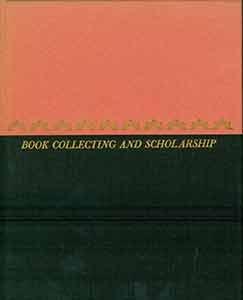
Book Collecting And Scholarship
Idioma: Inglés
Publicado por University of Minnesota Press, Minneapolis, 1954
Librería: Legacy Books, Louisville, KY, Estados Unidos de America
Calificación del vendedor: 5 de 5 estrellas

Original o primera edición
EUR 6,44
Envío por EUR 6,47
Se envía dentro de Estados Unidos de AmericaCantidad disponible: 1 disponibles
Ańadir al carritoHardcover. Condición: Good. 1st Edition. First edition, 12mo, 67pp, pink paper over boards and black cloth, with gilt titles, reddish pastedowns and endpapers, light general wear, housed in clear protective mylar dust jacket.
-

Colton's New Sectional Map of the State of Missorui
Publicado por VKM, Fort Worth, 1979
Librería: Young & Sons Enterprises, Apache, OK, Estados Unidos de America
Calificación del vendedor: 4 de 5 estrellas

EUR 8,84
Envío por EUR 4,74
Se envía dentro de Estados Unidos de AmericaCantidad disponible: 1 disponibles
Ańadir al carritoStapled Booklet. Condición: Very Good +. No Jacket. Facsimile. Reprint of the 1869 map. This is a very nice copy with minimal evidence of have been used. No names or writing within. NOT holepunched. Size: 4to - over 9ľ" - 12" tall.
-
THE BOOKMAN: September 1931
Publicado por The Bookman Publishing, NY, 1931
Librería: North Country Books, Milton, VT, Estados Unidos de America
Calificación del vendedor: 3 de 5 estrellas

EUR 8,89
Envío por EUR 5,13
Se envía dentro de Estados Unidos de AmericaCantidad disponible: 1 disponibles
Ańadir al carritoPaperback. Condición: Fair. Stapled magazine, missing front cover, wear to rear cover and partial damp staining affecting the magazine at the top blank margins. An acceptable reading copy.
-

A Manual to Accompany Colton's Missionary Map of the World Classic Reprint
Librería: PBShop.store US, Wood Dale, IL, Estados Unidos de America
Calificación del vendedor: 5 de 5 estrellas
EUR 26,03
Gastos de envío gratis
Se envía dentro de Estados Unidos de AmericaCantidad disponible: 15 disponibles
Ańadir al carritoPAP. Condición: New. New Book. Shipped from UK. Established seller since 2000.
-
Book Collecting and Scholarship
Idioma: Inglés
Publicado por University of Minnesota Press, Minneapolis, 1954
Librería: Clayton Fine Books, Shepherdstown, WV, Estados Unidos de America
Calificación del vendedor: 4 de 5 estrellas
Original o primera edición
EUR 22,21
Envío por EUR 5,18
Se envía dentro de Estados Unidos de AmericaCantidad disponible: 1 disponibles
Ańadir al carritoHardcover. Condición: Fine. Estado de la sobrecubierta: Fine. First Edition. Near fine in black and orange cloth-covered boards with tasteful design and title stamped in gold. Fine glassine dust jacket. Light fading to boards only flaw. An attractive little book publishing lectures presented at the opening ceremony of the James Ford Bell Room at the University of Minnesota. Designed by Jane McCarthy. "Gift" is printed on the colophon page.
-
A Manual to Accompany Colton's Missionary Map of the World Classic Reprint
Librería: PBShop.store UK, Fairford, GLOS, Reino Unido
Calificación del vendedor: 5 de 5 estrellas
EUR 25,16
Envío por EUR 3,81
Se envía de Reino Unido a Estados Unidos de AmericaCantidad disponible: 15 disponibles
Ańadir al carritoPAP. Condición: New. New Book. Shipped from UK. Established seller since 2000.
-
National Geographic September 1944 (Volume LXXXVI, Number Three)
Publicado por National Geographic Society, 1944
Librería: JR Books, Grand Rapids, MI, Estados Unidos de America
Calificación del vendedor: 5 de 5 estrellas
EUR 16,87
Envío por EUR 3,87
Se envía dentro de Estados Unidos de AmericaCantidad disponible: 1 disponibles
Ańadir al carritopaperback. Condición: Good. Spine and cover repaired with clear tape.
-
Book Collecting and Scholarship
Publicado por University of Minnesota Pres, 1954
Librería: Book Alley, Pasadena, CA, Estados Unidos de America
Calificación del vendedor: 4 de 5 estrellas
EUR 17,77
Envío por EUR 5,18
Se envía dentro de Estados Unidos de AmericaCantidad disponible: 1 disponibles
Ańadir al carritoHardcover. Condición: Good. NO DUST JACKET. Good used with wear and signs of age but is still in solid reading condition.
-

A Manual to Accompany Colton''s Missionary Map of the World (Classic Reprint)
Librería: PBShop.store US, Wood Dale, IL, Estados Unidos de America
Calificación del vendedor: 5 de 5 estrellas
EUR 35,49
Gastos de envío gratis
Se envía dentro de Estados Unidos de AmericaCantidad disponible: 15 disponibles
Ańadir al carritoHRD. Condición: New. New Book. Shipped from UK. Established seller since 2000.
-
Book Collecting and Scholarship
Publicado por University of Minnesota Pres
Librería: Wonder Book, Frederick, MD, Estados Unidos de America
Miembro de asociación: ABAA ILAB
Calificación del vendedor: 5 de 5 estrellas
EUR 17,74
Gastos de envío gratis
Se envía dentro de Estados Unidos de AmericaCantidad disponible: 1 disponibles
Ańadir al carritoCondición: Very Good. Very Good condition. No Dust Jacket (book collecting ) A copy that may have a few cosmetic defects. May also contain light spine creasing or a few markings such as an owner's name, short gifter's inscription or light stamp.
-
A Manual to Accompany Colton''s Missionary Map of the World (Classic Reprint)
Librería: PBShop.store UK, Fairford, GLOS, Reino Unido
Calificación del vendedor: 5 de 5 estrellas
EUR 33,52
Envío por EUR 4,81
Se envía de Reino Unido a Estados Unidos de AmericaCantidad disponible: 15 disponibles
Ańadir al carritoHRD. Condición: New. New Book. Shipped from UK. Established seller since 2000.
-
BOOK COLLECTING AND SCHOLARSHIP
Publicado por University of Minnesota Press, 1954
Librería: THE FINE BOOKS COMPANY / A.B.A.A / 1979, ROCHESTER, MI, Estados Unidos de America
Miembro de asociación: ABAA ILAB
Calificación del vendedor: 4 de 5 estrellas
Original o primera edición
EUR 14,43
Envío por EUR 10,78
Se envía dentro de Estados Unidos de AmericaCantidad disponible: 1 disponibles
Ańadir al carritoFIRST EDITION. BOOK COLLECTING AND SCHOLARSHIP, University of Minnesota Press, 1954, first edition, some fading to the upper section of the spine (the boards section), else fine in like dust-wrapper. 1/750 copies.
-

A Manual to Accompany Colton's Missionary Map of the World (Classic Reprint)
Librería: Forgotten Books, London, Reino Unido
Calificación del vendedor: 4 de 5 estrellas
EUR 16,37
Gastos de envío gratis
Se envía de Reino Unido a Estados Unidos de AmericaCantidad disponible: Más de 20 disponibles
Ańadir al carritoPaperback. Condición: New. Print on Demand. This book provides an overview of Christian missionary stations that were founded in various parts of the world during the 19th century. The stations were established by a range of different Christian denominations with the aim of spreading Christianity and providing social services such as education and healthcare to local communities. The author has carefully compiled a comprehensive list of these stations, including their locations, the denominations that founded them, and the dates they were established. This information is presented on a series of detailed maps that illustrate the global reach of Christian missionary activity during this period. The book also explores the complex history of Christian missions, discussing the motivations of the missionaries, the challenges they faced, and the impact their work had on both the local communities and the development of Christianity worldwide. Overall, this book serves as a valuable resource for anyone interested in the history of Christian missions and its global impact. This book is a reproduction of an important historical work, digitally reconstructed using state-of-the-art technology to preserve the original format. In rare cases, an imperfection in the original, such as a blemish or missing page, may be replicated in the book. print-on-demand item.
-
Book Collecting and Scholarship.
Publicado por Minneapolis: University of Minnesota Press., 1954
Librería: Wittenborn Art Books, San Francisco, CA, Estados Unidos de America
Calificación del vendedor: 5 de 5 estrellas
EUR 44,43
Envío por EUR 8,63
Se envía dentro de Estados Unidos de AmericaCantidad disponible: 1 disponibles
Ańadir al carritoCondición: Good. 12mo. 67 pp. Black and red cloth-covered boards with gilt spine and gilt lettering on front board. Very good with light sunning. In brodart jacket with red laid endpapers. Red illustrated capitals. Copy number 46 of a special edition of 750 copies. From the collection of the late Frederick Ruffner, Jr., founder of Gale Research, Detroit.
-
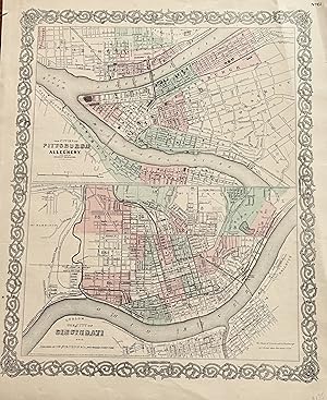
The Cities of Pittsburgh and Allegheny The City of CINCINNATI, OHIO with parts of adjacent boroughs, Pennsylvania:
Publicado por Colton, J. H., New York, 1855
Librería: mediumraremaps.com, Franklin, TN, Estados Unidos de America
Calificación del vendedor: 4 de 5 estrellas
Mapa
EUR 35,54
Envío por EUR 5,18
Se envía dentro de Estados Unidos de AmericaCantidad disponible: 1 disponibles
Ańadir al carrito12 1/2 X 15 3/4 INCHES. This map page has two maps. The upper map is of Pitts burgh and Allegheny. It is accopnyied by the lower half map of Cincinnati. Most important is the connection between the two cities; both were mated physically and economically by the Ohio River. These are very nice maps suitable for framing. it was hand colored in 1855 when the map was produced. Very good with a couple of repaired tears using archival mending tape.
-
National Geographic Magazine September 1944, Includes a Series of 8 FABULOUS Full-page B/W Surfing Photos with Short Paragraph Captions By J. H. Ball or Doc Ball , as the Surfers Know Him By, Surf-Boarders Capture California , Also Articles Rhodesia & C
Publicado por National Geographic Society, 1944, 1944
Librería: Bluff Park Rare Books, LONG BEACH, CA, Estados Unidos de America
Miembro de asociación: IOBA
Calificación del vendedor: 4 de 5 estrellas
Original o primera edición
EUR 63,09
Envío por EUR 7,63
Se envía dentro de Estados Unidos de AmericaCantidad disponible: 1 disponibles
Ańadir al carritoSoft Cover. No Jacket. First Edition. Soft Cover. No Jacket. First Edition. Magazine, Cover light Rub Scuff Marks & Circle Residue Coffee Cup ?, wear slight Aging , VG/NF-, AS-IS, SOFTCOVER, Interior Nice Tight Clean light FoX Wear, 384 pages + Ads, , also articles Rhodesia & Cecil John Rhodes, Bare Feet & Burros of Haiti, includes Photo Tom Blake on Surfboard with his World Champion Spaniel Dog Surfer, Rusty , ETC. ALSO Series on Working & Wild Dogs with color Photos, includes 24 pages in Color & many B/W photos , Magazine Editor Gilbert Grosvenor, with illust from Paintings by Walter A. Weber.
-
Colton's Sectional Map of Missouri
Idioma: Inglés
Publicado por Colton, New York, 1866
Librería: Bohemian Bookworm, Flemington, NJ, Estados Unidos de America
Calificación del vendedor: 1 de 5 estrellas

Original o primera edición
EUR 551,39
Envío por EUR 3,45
Se envía dentro de Estados Unidos de AmericaCantidad disponible: 1 disponibles
Ańadir al carritoHardcover. Condición: Very Good. No Jacket. 1st Edition. Wonderful oversized pocket-sized map and engraved ornamental headings, several folds into original brown cloth small folder, VG, a few wrinkles but doesn't appear to be torn or missing pieces, 1st edn, about b30" x 35" hand coloured map.
-
Colton's Map of the Southern States Showing the Counties & Railroads (Cities, Towns, Railroad Stations)
Idioma: Inglés
Publicado por G. W. and C. B. Colton, New York, 1867
Librería: Bohemian Bookworm, Flemington, NJ, Estados Unidos de America
Calificación del vendedor: 1 de 5 estrellas
EUR 683,81
Envío por EUR 3,45
Se envía dentro de Estados Unidos de AmericaCantidad disponible: 1 disponibles
Ańadir al carritoHardcover. Condición: Very Good. VG, f/o colour map of the region in original 24mo brown gilt titled covers newly rebacked, about 25" x 32", excellent map of Reconstruction South.
-

Colton's Vermont
Publicado por New York, New York, 1870
Librería: High Ridge Books, Inc. - ABAA, South Deerfield, MA, Estados Unidos de America
Miembro de asociación: ABAA ESA ILAB SNEAB
Calificación del vendedor: 5 de 5 estrellas
EUR 66,64
Envío por EUR 7,85
Se envía dentro de Estados Unidos de AmericaCantidad disponible: 1 disponibles
Ańadir al carrito35x28.2 cm. Original cloth folder, front board detached. Fair condition overall. Repairs along several folds, small loss at two fold junctions in New York State. Full color by town. Inside front cover has a small contemporary bookseller's paste-down from Greenfield, Massachusetts. This is a folding version of the map of Vermont which appeared in Colton's General Atlas.
-
Colton's New Hampshire, Colored Map 1874 Atlas
Idioma: Inglés
Librería: White Mountains, NH Books and Maps, Lincoln, NH, Estados Unidos de America
Calificación del vendedor: 4 de 5 estrellas
EUR 56,20
Envío por EUR 6,90
Se envía dentro de Estados Unidos de AmericaCantidad disponible: 1 disponibles
Ańadir al carritoNo Binding. Condición: Near Fine. Measuring 14-1/2"/W margins. Borders and counties are colored. No damage, very clean with a bit of tanning around edges, normal for this age paper.
-
National Geographic Magazine September 1944, Includes a Series of 8 FABULOUS Full-page B/W Surfing Photos with Short Paragraph Captions By J. H. Ball or Doc Ball , as the Surfers Know Him By, Surf-Boarders Capture California , Also Articles Rhodesia & C
Publicado por National Geographic Society, 1944
Librería: Bluff Park Rare Books, LONG BEACH, CA, Estados Unidos de America
Miembro de asociación: IOBA
Calificación del vendedor: 4 de 5 estrellas
Original o primera edición
EUR 71,97
Envío por EUR 7,63
Se envía dentro de Estados Unidos de AmericaCantidad disponible: 1 disponibles
Ańadir al carritoSoft Cover. No Jacket. First Edition. Magazine, Cover light Rub, wear slight Aging , VG+/NF, AS-IS, SOFTCOVER, Interior Nice Tight Clean light FoX Wear, 384 pages + Ads, Tiny Tear Back Cover Edge , also articles Rhodesia & Cecil John Rhodes, Bare Feet & Burros of Haiti, includes Photo Tom Blake on Surfboard with his World Champion Spaniel Dog Surfer, Rusty , ETC. ALSO Series on Working & Wild Dogs with color Photos, includes 24 pages in Color & many B/W photos , Magazine Editor Gilbert Grosvenor, with illust from Paintings by Walter A. Weber.
-
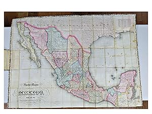
Nuevo Mapa de Mexico (RARE. HAND-COLORED, 1871)
Idioma: Espańol
Publicado por G. W. & C. B. Colton & Co., 1871
Librería: Shelley and Son Books (IOBA), Hendersonville, NC, Estados Unidos de America
Miembro de asociación: IOBA
Calificación del vendedor: 5 de 5 estrellas
EUR 4.442,76
Envío por EUR 5,61
Se envía dentro de Estados Unidos de AmericaCantidad disponible: 1 disponibles
Ańadir al carritoHardcover. Condición: Very Good. Early Edition, 1871. HAND-COLORED, BEAUTFULLY INTACT MAP OF MEXICO, 1871. By George Woolworth Colton and Charles B. Colton. Written in Spanish. This very large (37" wide x 50.5" long) lithograph folding map is housed in a hardcover, brown publisher's cloth binding. Cover is lettered in gilt with blind debossed ornamentation. Spine is plain. Map is printed on an onion skin vellum, folded four times at the width, and thirteen times at its length. The map itself bears a lovely ornamented boarder in black along top and side edges. Includes scale and latitude and longitudinal coordinates data. When folded within the closed book, dimensions are 8.25" x 5" x 0.5".ABOUT THE CARTOGRAPHERS: George Woolworth Colton (1827-1901) was the son of Joseph H. Colton (1800-1893), one of the more prominent American cartographers in the mid-19th century. The elder Colton headed J. H. Colton and Company and began publishing maps in New York in the 1830s. The firm originally excelled in acquiring copyrights of previously published maps. Included was the map plates of David H. Burr, another prominent American cartographer. The elder Colton's first product was an 1833 reprint of David Burr's 1830 map of New York State, re-engraved by Samuel Stiles. Colton reprinted several other Burr maps, including New York and Ohio, which were reissued for more than two decades. From 1850 to 1887, a major specialty of the Colton firm was the production of pocket railroad maps and guides. The Colton publishing firm was taken over in the middle of the century by Joseph Colton's two sons, George W. Colton and Charles B. Colton. It was 28 year old George Colton who organized and compiled the most popular product of J. H. Colton Company, namely Colton's Atlas of the World, the first volume of which appeared in 1855 and focused on North and South America. (Map History, UCLA) CONDITION: Two small tears toward the center at the two fold corners right below the "M" and the "E" within the "Golfo de Mexico", yet the integrity of the map remains uncompromised. Some occasional foxing as to be expected, with minor crimping at the top right edge, yet in stunning condition for its age. Binding shows general wear and is reinforced by vintage publisher's cloth at the joints and inner hinges. Previous owner's name written in pencil on the front pastedown. Hand painted colors are exquisite. An absolutely lovely, rare copy. The background has been included within the photograph to help give size perspective, as it is stretched out on a long table. Please note that the open book at the left is the actual binding, housing the folded map. As this piece is very large and fragile, we prefer to NOT offer additional photographs, as two people are needed to unfold this very delicate map, and we wish to protect it from any possible damage in the folding process. Requests for additional photographs of the binding are welcomed. This item will be delivered with "adult signature required". Full refund if not satisfied.
-
Colton's Map of Connecticut (Folding Pocket map) 1869.
Idioma: Inglés
Librería: White Mountains, NH Books and Maps, Lincoln, NH, Estados Unidos de America
Calificación del vendedor: 4 de 5 estrellas
EUR 64,85
Envío por EUR 6,90
Se envía dentro de Estados Unidos de AmericaCantidad disponible: 1 disponibles
Ańadir al carritoNo Binding. Condición: Near Fine. A nice example with hand-colored map folded into dark brown blind-stamped stiff bds. VG+ condition, bds are quite rough with wear, poor.
-
MAP OF THE STATE OF NEW YORK ACCOMPANYING THE LEGISLATIVE MANUAL 1873. COLT
Publicado por (NY, 1873)., 1873
Librería: Steve Finer - Rare Books, Greenfield, MA, Estados Unidos de America
Miembro de asociación: SNEAB
Calificación del vendedor: 4 de 5 estrellas
EUR 66,64
Envío por EUR 10,31
Se envía dentro de Estados Unidos de AmericaCantidad disponible: 1 disponibles
Ańadir al carritoLarge, folding hand colored map, approx. 28" x 26" with thick ornamental border, counties outlined in color, etc. Detached from original red gilt cloth binding, few small fold breaks, but essentially a nice clean copy. The map is engraved by J.M.Atwood and bears an 1852 copyright date.
-

Colton's Massachusetts, Connecticut and Rhode Island
Publicado por Colton, G. W. & C. B., New York, 1866
Librería: mediumraremaps.com, Franklin, TN, Estados Unidos de America
Calificación del vendedor: 4 de 5 estrellas
Mapa
EUR 75,53
Envío por EUR 5,18
Se envía dentro de Estados Unidos de AmericaCantidad disponible: 1 disponibles
Ańadir al carrito26 x 17 inches. Large two page map of MA, CT and RI. Finely colored throughout with three color county differential coloring scheme. Good with multiple tears expertly repaired with archival mending tape.
-
MAP SHOWING THE BURLINGTON, CEDAR RAPIDS AND MINNESOTA RAILWAY And Its Connections
Publicado por G.W. & C.B. Colton: NY, 1868
Librería: John K King Used & Rare Books, Detroit, MI, Estados Unidos de America
Calificación del vendedor: 5 de 5 estrellas
EUR 153,28
Envío por EUR 4,74
Se envía dentro de Estados Unidos de AmericaCantidad disponible: 1 disponibles
Ańadir al carritoPaperback. Condición: Good. 34 x 25", colored map, folds, edges chipped, creased and unevenly cut, toning at folds, horizontal center fold torn halfway through from left edge, but still an interesting map showing the Mississippi Valley from Minnesota down to southern Missouri. SWAF. Not a reprint!
-
Map of the Richmond and Louisville Railroad, Connecting the Railroads of Virginia with the Railroads of Kentucky on the Shortest Route East and West from the Mississippi Valley to the Atlantic Ocean
Publicado por Colton & Co, N.Y., 1882
Librería: Recycled, Corte Madera, CA, Estados Unidos de America
Calificación del vendedor: 5 de 5 estrellas
Mapa Original o primera edición
EUR 155,50
Envío por EUR 6,04
Se envía dentro de Estados Unidos de AmericaCantidad disponible: 1 disponibles
Ańadir al carritoSoft cover. Condición: Very Good. Illustrated Ilustrador. 1st Edition. Lithographed map, folded into stiff tan card wrappers with the title on the cover, which is tanned and chipped. The map itself is 48 x 25.5 inches, but the wrappers only 5 by 10 inches, so there are fold lines, a few tears at those lines, and minor edge chipping to the map.
-
Colton's Map of Kentucky
Publicado por G.W. & C.B. Colton & Co.
Librería: Wonder Book, Frederick, MD, Estados Unidos de America
Miembro de asociación: ABAA ILAB
Calificación del vendedor: 5 de 5 estrellas
EUR 167,12
Gastos de envío gratis
Se envía dentro de Estados Unidos de AmericaCantidad disponible: 1 disponibles
Ańadir al carritoCondición: Good. New York: G.W. & C.B. Colton, 1865. 24mo decoratively embossed cloth hardcover with gilt lettering to the front. Pubisher information on front pastedown. 29 x 56 cm Fold-out map of Kentucky with portions of adjoining states represented. State borders outlined in pink, counties shaded differing colors, with relief shown by hachures. Good condition. Near Fine cover is in remarkable condition. Front endpaper shows a small brown fleck. Brown ink "x"s marked though the center of the map, else Very Good to Near Fine. (Kentucky, Map) Inquire if you need further information.
-

Colton's Dominion of Canada, No. 3. The Provinces of New Brunswick, Nova Scotia and Prince Edward Island
Publicado por New York. Published by G.W. & C.B. Colton. 1880, 1880
Librería: J. Patrick McGahern Books Inc. (ABAC), Ottawa, ON, Canada
Miembro de asociación: ABAC ILAB
Calificación del vendedor: 4 de 5 estrellas
Mapa
EUR 158,75
Envío por EUR 8,63
Se envía de Canada a Estados Unidos de AmericaCantidad disponible: 1 disponibles
Ańadir al carritoHardcover. Condición: In mint condition, scarce. folding map on thin rice paper, 46x 67cm, (18"x 26.5"), hand coloured in outline, in the original blind decorated grey cloth, gilt titles on the upper cover, Newfoundland replaces Prince Edward Island on the upper cover title.
-

Colton's New Township Map of the Eastern Counties of Pennsylvania
Publicado por New York, New York, 1890
Librería: High Ridge Books, Inc. - ABAA, South Deerfield, MA, Estados Unidos de America
Miembro de asociación: ABAA ESA ILAB SNEAB
Calificación del vendedor: 5 de 5 estrellas
EUR 266,57
Envío por EUR 7,85
Se envía dentro de Estados Unidos de AmericaCantidad disponible: 1 disponibles
Ańadir al carritoOriginal cloth folder. Linen-backed but not dissected. fine condition. A late Colton issue of a map first published in 1865. Full color by town. Pastedown slip for J. L. Smith, map publisher in Philadelphia. Shows the eastern part of the state, to just past the Susquehanna River.


