Importe total (1 artículo artículos):
Destino del pedido:

brightly eng (1 resultados)
Ir a los resultados principales
Filtros de búsqueda
Tipo de artículo
- Todos los tipos de productos
- Libros (1)
- Revistas y publicaciones (No hay ningún otro resultado que coincida con este filtro.)
- Cómics (No hay ningún otro resultado que coincida con este filtro.)
- Partituras (No hay ningún otro resultado que coincida con este filtro.)
- Arte, grabados y pósters (No hay ningún otro resultado que coincida con este filtro.)
- Fotografías (No hay ningún otro resultado que coincida con este filtro.)
- Mapas (No hay ningún otro resultado que coincida con este filtro.)
- Manuscritos y coleccionismo de papel (No hay ningún otro resultado que coincida con este filtro.)
Condición Más información
- Nuevo (No hay ningún otro resultado que coincida con este filtro.)
- Como nuevo, Excelente o Muy bueno (No hay ningún otro resultado que coincida con este filtro.)
- Bueno o Aceptable (No hay ningún otro resultado que coincida con este filtro.)
- Regular o Pobre (No hay ningún otro resultado que coincida con este filtro.)
- Tal como se indica (1)
Encuadernación
- Todas
- Tapa dura (1)
- Tapa blanda (No hay ningún otro resultado que coincida con este filtro.)
Más atributos
- Primera edición (1)
- Firmado (No hay ningún otro resultado que coincida con este filtro.)
- Sobrecubierta (No hay ningún otro resultado que coincida con este filtro.)
- Con imágenes (1)
- No impresión bajo demanda (1)
Idioma (1)
Precio
- Cualquier precio
- Menos de EUR 20 (No hay ningún otro resultado que coincida con este filtro.)
- EUR 20 a EUR 45 (No hay ningún otro resultado que coincida con este filtro.)
- Más de EUR 45
Gastos de envío gratis
- Envío gratis a Estados Unidos de America (No hay ningún otro resultado que coincida con este filtro.)
Ubicación del vendedor
Valoración de los vendedores
-
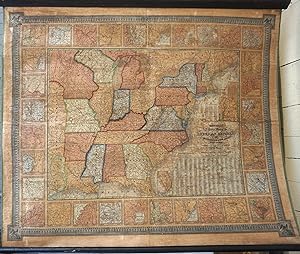
Mitchell's National Map of the American Republic or, United States of North America: together with Maps of the Vicinities of Thirty-two of the Principal Cities and Towns in the Union : (table) Population of Each County & c., in the Different States and Territories of the United States in 1840
Publicado por August Mitchell, Philadelphia, 1843
Librería: Antipodean Books, Maps & Prints, ABAA, Garrison, NY, Estados Unidos de America
Miembro de asociación: ABAA ANZAAB ESA ILAB
Calificación del vendedor: 3 de 5 estrellas

Original o primera edición
EUR 3.404,16
Envío por EUR 8,58
Se envía dentro de Estados Unidos de AmericaCantidad disponible: 1 disponibles
Ańadir al carritoFirst edition. A rare wall map published by Mitchell, with only one copy cited at the Clements Library (OCLC: 9123797110.) The map was published in 1843 in a different folded format, with three sheets and bound in a gilt leather folder. In this presentation, the large scale map of the eastern United States is surrounded with insets of major harbors and towns. The large Iowa Territory and Minnesota are not yet named. The map shows the country west to the Indian Territory west of Missouri, including the eastern part of Texas, north including most of Maine with a touch of Canada, and south through most of Florida. In the lower right, are tables "Population of Each County & c., in the Different States and Territories of the United States in 1840". The whole is bordered with an elaborate design. The inset of Maine is captioned "Map of the North-eastern Boundary of the United States according to the Treaty of 1842." From the "National Map Series that Mitchell produced by subscription over many years. Drawn by James H. Young and engraved by J. H. Brightly, published by S. Augustus Mitchell, Philadelphia, 8 1/2 South - 1843 - 7th St. With the original rollers. Original color but varnished as usual. Archivally repaired, backed on linen, supporting many cracks with no loss. Printed area 45 x 39" (114 x 96.5 cm) on paper 48 x 40" (122 x 101 cm). Map of the southern part of Florida; Inset title:; Map of the north-eastern boundary of the United States according to the treaty of 1842; Inset title:; Vicinity of Burlington, Vermont; Inset title:; Vicinity of Portland, Maine; Inset title:; Vicinity of Portsmouth, New Hampshire; Inset title:; Vicinity of Boston, Massachusetts; Inset title:; Vicinity of Lowell, Massachusetts; Inset title:; Vicinity of Providence, Rhode Island; Inset title:; Vicinity of Hartford, Connecticut; Inset title:; Vicinity of New Haven, Connecticut; Inset title:; Vicinity of Albany, New York; Inset title:; Vicinity of Savannah, Georgia; Inset title:; Vicinity of Natchez, Mississippi; Inset title:; Vicinity of New York, New York; Inset title:; Vicinity of Pittsburg, Pennsylvania; Inset title:; Vicinity of Nashville, Tennessee; Inset title:; Vicinity of Mobile, Alabama; Inset title:; Vicinity of Trenton, New Jersey; Inset title:; Vicinity of Rochester, New York; Inset title:; Vicinity of Raleigh, North Carolina; Inset title:; Vicinity of New Orleans, Louisiana; Inset title:; Vicinity of Philadelphia, Pennsylvania; Inset title:; Vicinity of Buffalo, New York; Inset title:; Vicinity of Charleston, South Carolina; Inset title:; Vicinity of Richmond, Virginia; Inset title:; Vicinity of Baltimore, Maryland; Inset title:; Vicinity of Detroit, Michigan; Inset title:; Vicinity of Cincinnati, Ohio; Inset title:; Vicinity of Indianapolis, Indiana; Inset title:; Vicinity of Springfield, Illinois; Inset title:; Vicinity of St. Louis, Missouri; Inset title:; Vicinity of Frankfort, Kentucky; Inset title:; Vicinity of Louisville, Kentucky; Inset title:; Vicinity of Washington, District of Columbia.