

Importe total (1 artículo artículos):
Destino del pedido:

bertelli ferrando (9 resultados)
Ir a los resultados principales
Filtros de búsqueda
Tipo de artículo
- Todos los tipos de productos
- Libros (3)
- Revistas y publicaciones (No hay ningún otro resultado que coincida con este filtro.)
- Cómics (No hay ningún otro resultado que coincida con este filtro.)
- Partituras (No hay ningún otro resultado que coincida con este filtro.)
- Arte, grabados y pósters (3)
- Fotografías (No hay ningún otro resultado que coincida con este filtro.)
- Mapas (3)
- Manuscritos y coleccionismo de papel (No hay ningún otro resultado que coincida con este filtro.)
Condición Más información
- Nuevo (No hay ningún otro resultado que coincida con este filtro.)
- Como nuevo, Excelente o Muy bueno (No hay ningún otro resultado que coincida con este filtro.)
- Bueno o Aceptable (No hay ningún otro resultado que coincida con este filtro.)
- Regular o Pobre (No hay ningún otro resultado que coincida con este filtro.)
- Tal como se indica (9)
Encuadernación
- Todas
- Tapa dura (No hay ningún otro resultado que coincida con este filtro.)
- Tapa blanda (No hay ningún otro resultado que coincida con este filtro.)
Más atributos
- Primera edición (1)
- Firmado (No hay ningún otro resultado que coincida con este filtro.)
- Sobrecubierta (No hay ningún otro resultado que coincida con este filtro.)
- Con imágenes (8)
- No impresión bajo demanda (9)
Idioma (1)
Precio
- Cualquier precio
- Menos de EUR 20 (No hay ningún otro resultado que coincida con este filtro.)
- EUR 20 a EUR 45 (No hay ningún otro resultado que coincida con este filtro.)
- Más de EUR 45
Gastos de envío gratis
- Envío gratis a Estados Unidos de America (No hay ningún otro resultado que coincida con este filtro.)
Ubicación del vendedor
Valoración de los vendedores
-

Genova
Publicado por Genova
Librería: Sergio Trippini, Gavirate, VA, Italia
Miembro de asociación: ALAI ILAB
Calificación del vendedor: 5 de 5 estrellas

Original o primera edición
EUR 1.800,00
Envío por EUR 48,00
Se envía de Italia a Estados Unidos de AmericaCantidad disponible: 1 disponibles
Añadir al carritoVeduta prospettica della città di Genova ripresa dal mare ed animata dalla presenza di svariati navigli che solcano le acque del Mar Ligure. L'incisione segue il modello proposto da Paolo Forlani nel 1567; si noti in particolare, oltre alla rappresentazione della città, l'orientazione della stessa determinata dall'indicazione dei quadranti di una semplice rosa dei venti. L'attribuzione e datazione è determinata dalla presenza in alcuni esemplari della prima edizione dell'opera "Civitatum aliquot insigniorum et locorum, magis munitorum exacta delineatio." pubblicata a Venezia proprio da Ferrando Bertelli nel 1568. Ottimo lo stato di conservazione generale. Autore: Ferrando Bertelli edit. Luogo: Genova. Anno: 1568. Tecnica: incisione in rame. Dimensioni: 162x293 mm.Rif: Valerio 1998: 43; Bifolco, Ronca 2018: III, 21.
-

Britania Insula Quae Duo Regna Continet Angliam Et Scotiam Cum Hibernia Adiacente
Publicado por Ferrando Bertelli, Venice, 1562
Librería: Clive A. Burden Ltd., Chalfont St. Giles, BUCKS, Reino Unido
Miembro de asociación: ABA ILAB
Calificación del vendedor: 5 de 5 estrellas
Mapa
EUR 23.258,27
Envío por EUR 25,65
Se envía de Reino Unido a Estados Unidos de AmericaCantidad disponible: 1 disponibles
Añadir al carritoNo binding. 480 x 350 mm., cut close with original extended margins as usually issued, with light water stain to upper right margin, otherwise in good condition. This map is derived from the extremely rare two-sheet one by George Lily (c.1510-59) printed in Rome in 1546. That was the first separately published map of the British Isles and is recognised as the first modern map of the Isles. Its sources were numerous with many up to date. The big improvement was in the depiction of Scotland. Lily was a son of the famous grammarian, or linguist, William Lily and was under the patronage of Reginald Pole, with whom he returned from Italy in 1556. He was a noted historian and Catholic exile in Rome. Unfortunately, that map is of remarkable rarity with just 14 examples currently recorded, only two of which are in private hands. Of the original highly influential map there were more than a dozen later derivatives, all separately published. In 1549 two woodcut maps were published in Antwerp both of which survive in just one known example. Similarly, one by Matteo Pagano in Venice, also a woodcut, is known in just one example. The first copper plate version was published in Rome in 1556, which is unsigned and bears the newly formed Jesuit Society insignia 'IHS' lower right, by which monogram it is usually known. Shortly after in 1562, Ferrando Bertelli (fl.1556-72) published this similarly orientated map in Venice. A simple title within a lined panel appears on the right side which is concluded with the imprint. A further panel on the left bears more text with the imprint of 'Ferando de Berteli exc. 1561'. The second 'I' in the date of the right cartouche appears added which likely is a last minute addition as the Bertelli imprint is dated 1561. Degrees of longitude and latitude are marked but the scale of miles is omitted. All four cardinals are named and are placed inside the border. The engraving itself is the work of the renowned Paolo Forlani (fl.1560-71), we know little about him. David Woodward expended considerable effort to catalogue his works. Forlani, or Furlani, came from Verona and died it is assumed in Venice in the mid-1570s, quite possible in one of the outbreaks of the plague which claimed thirty percent of the population. Caraci claimed his career began in 1558 without providing supporting evidence. The earliest dated map he signed is 1560, one of the world for Giovanni Camocio. Along with Giacomo Gastaldi he worked in Venice and produced some of the most attractive maps of the period. Provenance: private English collection. Bifolco & Ronca (2018) I p. 760; Karrow (1993) pp. 226 & 270; Lynam (1934); Meurer (2004) no. 6; Shirley (1991) 70; Tooley (1939) 272; Tooley (1999-2004); Woodward (1990) no. 12.
-

La nobile cita di Fiorenza
Publicado por 1568 circa, 1568
Librería: TABERNA LIBRARIA - ALAI - ILAB, Pistoia, PT, Italia
Miembro de asociación: ALAI ILAB
Calificación del vendedor: 5 de 5 estrellas
EUR 900,00
Envío por EUR 13,00
Se envía de Italia a Estados Unidos de AmericaCantidad disponible: 1 disponibles
Añadir al carritoIncisione a bulino, mm. 128x260. Tratta dall'opera "Civitatum aliquot insigniorum et locorum magis munitorum exacta delineatio " edita a Venezia nel 1568. Smarginata. In alto al centro il titolo. Veduta prospettica della città, basata sul modello del Rosselli, rispetto alla quale tuttavia è speculare, ovvero realizzata incidendo nella matrice di rame il disegno senza considerare che nella stampa verrà rovesciato. Più probabilmente, si tratta una copia semplificata e dell'immagine pubblicata un anno prima nella raccolta di Paolo Forlani. Assai rara. Piccolissimo strappo restaurati (circa 1 cm) al marg. sup.
-
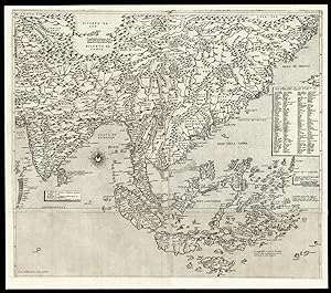
Il disegno della terza parte dell'Asia.
Publicado por 1562 and c1568]., [Venice,, 1562
Librería: Daniel Crouch Rare Books Ltd, London, Reino Unido
Miembro de asociación: ABA ILAB PBFA
Calificación del vendedor: 5 de 5 estrellas
Mapa
EUR 149.091,47
Envío por EUR 23,16
Se envía de Reino Unido a Estados Unidos de AmericaCantidad disponible: 1 disponibles
Añadir al carritoGastaldi's seminal map of Southeast Asia Engraved map on three sheets joined, bearing three watermarks, upper left sheet with ladder in shield under cross pommy B (Woodward 256), upper right with lamb, paschal with straight standard C (Woodward 48), lower sheet, only lower half of ladder in shield under six-pointed star K (Woodward 253). A fine example of Gastaldi's map Southeast Asia, the most influential map of the region published in the sixteenth century, and the first map to name Singapore; here present with the rare southern extension sheet, incorporating the Java and the lucrative Spice Islands. Giacomo Gastaldi (c1500-1567), originally from Piedmont, established himself as a cartographer in Venice, where he was given the notable title of 'Cosmographer to the Republic'. He was a prolific mapmaker, with a body of work numbering at least 109 pieces, including contributions to the 1548 Venice edition of Ptolemy's 'Geogra a', and Ramusio's 'Navigationi et viaggi'. Gastaldi's maps of Asia are considered amongst the most significant representations of the continent, as the first pieces of cartography to name, and even show, many of the areas depicted. Originating from Venice, they also reflect the Republic's dominance of early exploration, particularly in Asia. The city's crucial position allowed for Western contact with the East, although this relationship was becoming progressively threatened by the expansion of the Ottoman Empire. The present map bears the same scale bar as Gastaldi's first and second parts of Asia, and matches with their latitudes and longitudes. It has been dubbed the most influential map of the region published in the sixteenth century and, as noted by Schilder, 'in the representation of the coastlines, his maps are superior to all previous known maps of Asia, either drawn by hand or printed'. After Gastaldi's death, it was augmented by two further sheets, as in the present example, narrower in size, and with the imprint 'To be sold at the San Marco bookshop in Venice' (transl.). The map extends from central Asia to China and is particularly important for its depiction of the islands below the Equator. Alongside the Moluccas, labelled the "Isole di Ambon", Gastaldi includes a note explaining that "in these islands there are cloves, cinnamon, nutmeg, pepper, sandalwood, ambergris, and many spices" (transl.), reflecting the importance of these resources to Venetian trade. e Philippines appear as "Philippina" and Borneo in its present nomenclature; found below these is Java, labelled "Giava Magiore" to distinguish it from the fictitious "Giava Minore" added by Forlani. Significantly, this is the first map to name Singapore and Cambodia. Gastaldi's sources vary from Venetian explorers, such as Marco Polo and Pigafetta, to the records of Spanish and Portuguese voyages, most notably that of Magellan. As noted by Nordenskjöld, it is likely that he had access to the extensive library of the Fugger family, since Marcus Fugger was an acquaintance and the sole dedicatee of this map, as well as to the maps in the Sala dello Scudo, which he was commissioned to paint, thanks to his close connection with the Venetian Secretary of State. Gastaldi's maps set a new standard in cartographic representations of Asia, and formed the basis of those subsequently published by Ortelius, De Jode and Mercator. Although Bifolco records 41 examples of this map held in institutions worldwide, this map is extremely rare on the market. We have been able to trace only two examples appearing in the last 50 years. Bifolco 74 state 2; Nordenskjöld, pp. 396- 406, The Geographical Journal vol. 13, April 1899; Schilder p.7, The Map Collector 17, December 1981; Suárez, The early mapping of Southeast Asia, pp.130-157, 1999; Tooley pp.20, 21.
-

Novo et vero dissegno della Marca di Ancona con li suoi confine.
Publicado por Venezia, 1565
Librería: libreria antiquaria perini Sas di Perini, Verona, VR, Italia
Miembro de asociación: ALAI ILAB
Calificación del vendedor: 5 de 5 estrellas
Arte / Grabado / Póster
EUR 4.000,00
Envío por EUR 40,00
Se envía de Italia a Estados Unidos de AmericaCantidad disponible: 1 disponibles
Añadir al carritoIncisione in rame, mm 266x400. Importante e rara carta geografica della Marca di formato grande, dopo la piccola incisione di Gastaldi del 1548 inserita nella "Geografia", da cui deriva indirettamente. Bertelli segue infatti fedelmente la carta di Camocio del 1563 senza correggere gli errori (Bifolco-Ronca pag 270). Raffigura tutte le Marche e parte dell'Abruzzo, da Cattolica a Pescara, oltre a rappresentare anche parte di Toscana, Umbria e Lazio (Angiari, Perugia, Narni, Vicovaro, L'Aquila. Ampi margini, ottimo stato di conservazione, due rinforzi al verso. Almagi?, Monumenta Italiae Cartographica, pag 91; Bifolco-Ronca, Cartografia rara italiana, 109; Perini, L'Italia e le sue regioninelle antiche carte geografiche, pag. 97; Volpini, Le Marche nella cartografia; Valerio, L'Italia e le sue regione nella bottega dell'incisore, p. 78. Nr.cat: Cod 1974.
-

Nova descrittione di tutto il Ducado di Milano, del Piamonte, del paese de Svizzeri, et gran parte di altre regioni confinanti
Publicado por Venezia, 1567
Librería: libreria antiquaria perini Sas di Perini, Verona, VR, Italia
Miembro de asociación: ALAI ILAB
Calificación del vendedor: 5 de 5 estrellas
Arte / Grabado / Póster
EUR 9.000,00
Envío por EUR 40,00
Se envía de Italia a Estados Unidos de AmericaCantidad disponible: 1 disponibles
Añadir al carritoIncisione in rame, mm 300x455. Bellissima impressione su carta vergata priva di filigrana, ampi margini. La carta raffigura il Piemonte, la Liguria e la parte meridionale del Ducato ed Ë teoricamente il foglio inferiore di una grande carta in due fogli, il cui foglio settentrionale non fu mai stampato e non se ne conosce quindi alcun esemplare. La carta di Bertelli copia quella di Settala pubblicata da Hieronimus Cock ad Anversa nel 1560. Moltissime navi, un compasso ed il bel cartiglio centrale che riporta il titolo arricchiscono la parte inferiore della carta. Nel cartiglio di seguito al titolo Ë riportato" ridotta a perfettione in Venetia apresso Ferrando Bertelli Nel M.D.LXVII " . Ottimo esemplare con al verso alcuni leggeri veli di cellulosa a rinforzo.Woodward, Paolo Forlani, n. 69; Perini C. L'Italia e le sue regioni nelle antiche carte geografiche, p. 43-44; Bifolco-Ronca, Cartografia rara italiana, tav. 30; Valerio, L'Italia e le sue regioni nella bottega dell'incisore, p. 42; Lago, Imago Italiae, p. 331. Nr.cat: Cod 1842.
-
Crescentino
Publicado por Crescentino - (VC)
Librería: Sergio Trippini, Gavirate, VA, Italia
Miembro de asociación: ALAI ILAB
Calificación del vendedor: 5 de 5 estrellas
EUR 1.200,00
Envío por EUR 48,00
Se envía de Italia a Estados Unidos de AmericaCantidad disponible: 1 disponibles
Añadir al carritoPianta della città di Crescentino nel vercellese. Nell'angolo in basso a sinistra il monogramma FB, con ogni probabilità Ferrando Bertelli. Nel saggio di Marcel Destombes " Les cartes de Lafreri et assimilées." a p. 5, si legge:" Nous avons découvert dans différents portefeuilles une quinzaine de petites cartes qui semblent dues au burin de Ferrando Bertelli, l'une d'elles est datée de 1567. Ces plans, dont quelque uns seulement se trouvent au British Museum ne semblent appartenir à aucun atlas connu et peut-etre s'agit-il d'un jeu d'épreuves". La pianta di Crescentino fa parte di questa lista (p. 23, n° 188). Molto rara, ottima conservazione.
-
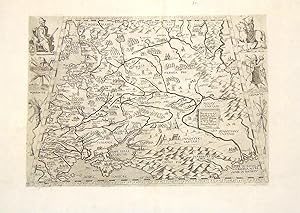
Nova descriptione de la moscovia per l'ecce.te m. Giacomo Gastaldo piemontese cosmografo. In Venetia anno M.D.L XII IIII
Publicado por Venezia, 1566
Librería: libreria antiquaria perini Sas di Perini, Verona, VR, Italia
Miembro de asociación: ALAI ILAB
Calificación del vendedor: 5 de 5 estrellas
Arte / Grabado / Póster
EUR 12.000,00
Envío por EUR 40,00
Se envía de Italia a Estados Unidos de AmericaCantidad disponible: 1 disponibles
Añadir al carritoIncisione in rame, firmata "Ferando Berteli" e datata in lastra al centro entro cartiglio, mm 365x265.Rara carta della Russia basata sul modello gastaldino che aveva illustrato l'edizione veneziana del "Rerum Muscoviticarum Commentarii" di Herberstein, pubblicato in origine a Vienna nel 1549. Von Herbenstein, ambasciatore austriaco in Russia raccolse informazioni geografiche, storiche e di costume e fornÏ notizie molto dettagliate sulla regione, fino ad allora sconosciuta o mal descritta. Gastaldi si era basato sulla carta inserita nell'opera ma la aveva riveduta e corretta con materiale recente di origine italianaBuona prova, impressa su carta vergellata coeva senza filigrana con ampi margini, in ottimo stato di conservazione. Bibliografia: Bagrow, A history of the cartography of Russia up to 1600, pp. 69 ff; Meurer, The Strabo Illustrated Atlas, p. 53, 39; Tooley, Italian Atlases, 498; Bella, Cartographia Rara, 117. Ä 12.000------------------------------------------------Etching and engraving, 1566, signed and dated in the plate in the cartouche at the center, mm 365x265, printed on contemporary laid paper without any watermark, wide margins, in very good condition except two minor restorations. Very rare map of Russia published by Ferrando Bertelli, and based on the Gastaldi map to illustrating the venetian edition of "Rerum Muscoviticarum Commentariis" by Von Herberstein, published for the first time in Vienna in 1549. Von Herbenstein, an Austrian diplomat native of Slovenia, twice ambassador in Moscow in 1517 and in 1526, gathered many geographical, historical and etnographical information, which he published in his book, and used in printed map of the region in 1546. Bagrow, A history of the cartography of Russia up to 1600, pp. 69ff; Meurer, The Strabo Illustrated Atlas, p. 53, 39; Tooley, Italian Atlases, 498; Bella, Cartographia Rara, 117. Nr.cat: P2050307.
-

Venetia.
Librería: Daniel Crouch Rare Books Ltd, London, Reino Unido
Miembro de asociación: ABA ILAB PBFA
Calificación del vendedor: 5 de 5 estrellas
Mapa
EUR 23.854,63
Envío por EUR 23,16
Se envía de Reino Unido a Estados Unidos de AmericaCantidad disponible: 1 disponibles
Añadir al carritoPossibly an entirely new view of Venice Etched bird's-eye view of Venice, laid paper without watermark, corners renewed. An apparently unrecorded map of Venice, the capital of a vast empire, a mercantile centre, and a departure point for travellers to the East. Located at the crossroads between East and West, Venice was a destination for foreign merchants and pilgrims. Bertelli's view is stylised, and not directly based on any previous view, being slightly oriented with the north-northeast to the top. It is probably closest in perspective to Benedetto di Bordone's 'Venice' (1528), than Jacopo de' Barbari's (1500). It almost certainly precedes that of Paolo Forlani (1565), and given that Bertelli was one of three prominent Venetian publishers to employ Forlani (the others were Giovanni Francesco Camocio and Bolgnini Zaltieri) during his time in Venice (1560-1574), it is entirely likely that Bertelli's own small map inspired the production of Forlani's much larger and more detailed map, and was then outclassed by it, resulting in its swift redundancy, and current scarcity. Ferrando Bertelli (c1525-1572), is best known as a Venetian publisher of prints, after Titian, Farinati, Giulio Romano, Battista del Moro, and Dürer; and maps. Some he engraved himself, others were engraved for him by Paolo Forlani, Giovanni Francesco Camocio, Mario Cartaro, Sanuto, Cavalieri, and Domenico Zenoi. Karrow records Bertelli as having signed at least one other map, a copy of Giacomo Gastaldi's map 'Li'Isola Cuba e piu Setentrional dela Spagnola', (c1566), as "F.B.", although he usually signed his name in full, and with a flourish, as is evident on the other maps of islands he engraved in about 1566. Provenance: 1. With Helmut Rumbler Kunsthandel, Frankfurt am Main, 2010 Bury, 'The Print in Italy 1550-1625', British Museum, London 2001, page 222; not in Bifalco; not in Karrow.


