
Importe total (1 artículo artículos):
Destino del pedido:

bay biscay (6 resultados)
Ir a los resultados principales
Filtros de búsqueda
Tipo de artículo
- Todos los tipos de productos
- Libros (4)
- Revistas y publicaciones (No hay ningún otro resultado que coincida con este filtro.)
- Cómics (No hay ningún otro resultado que coincida con este filtro.)
- Partituras (No hay ningún otro resultado que coincida con este filtro.)
- Arte, grabados y pósters (No hay ningún otro resultado que coincida con este filtro.)
- Fotografías (No hay ningún otro resultado que coincida con este filtro.)
- Mapas (2)
- Manuscritos y coleccionismo de papel (No hay ningún otro resultado que coincida con este filtro.)
Condición Más información
- Nuevo (No hay ningún otro resultado que coincida con este filtro.)
- Como nuevo, Excelente o Muy bueno (No hay ningún otro resultado que coincida con este filtro.)
- Bueno o Aceptable (5)
- Regular o Pobre (No hay ningún otro resultado que coincida con este filtro.)
- Tal como se indica (1)
Encuadernación
- Todas
- Tapa dura (No hay ningún otro resultado que coincida con este filtro.)
- Tapa blanda (No hay ningún otro resultado que coincida con este filtro.)
Más atributos
- Primera edición (No hay ningún otro resultado que coincida con este filtro.)
- Firmado (No hay ningún otro resultado que coincida con este filtro.)
- Sobrecubierta (No hay ningún otro resultado que coincida con este filtro.)
- Con imágenes (4)
- No impresión bajo demanda (6)
Idioma (2)
Gastos de envío gratis
- Envío gratis a Estados Unidos de America (No hay ningún otro resultado que coincida con este filtro.)
Ubicación del vendedor
Valoración de los vendedores
-
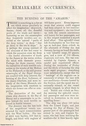
The Burning of the mail steam ship Amazon, in the Bay of Biscay. An original article from The Annual Register for 1852.
Publicado por Annual Register, London, 1852
Librería: Cosmo Books, Shropshire., Reino Unido
Calificación del vendedor: 5 de 5 estrellas

EUR 15,46
Envío por EUR 13,74
Se envía de Reino Unido a Estados Unidos de AmericaCantidad disponible: 3 disponibles
Ańadir al carritoBooklet - Unbound Pages. Condición: Very Good. 8 pages. An authentic standalone article, extracted from a larger volume. Not a reprint or reproduction, but an original work in its own right. Preserved in a modern card cover, prepared for practicality - an unassuming but serviceable presentation that favours function over finery. Size: 13 x 20 cms. Category: Annual Register; Cosmo Books : 29 years on ABE, 47 years taking care of customers. A bookseller you can rely on.
-
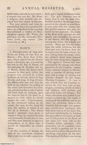
Destruction of the East Indianman ship Kent, by Fire, in the Bay of Biscay. An original article from The Annual Register for 1825.
Publicado por Annual Register, London, 1825
Librería: Cosmo Books, Shropshire., Reino Unido
Calificación del vendedor: 5 de 5 estrellas
EUR 16,76
Envío por EUR 13,74
Se envía de Reino Unido a Estados Unidos de AmericaCantidad disponible: 2 disponibles
Ańadir al carritoBooklet - Unbound Pages. Condición: Very Good. 5 pages. An authentic standalone article, extracted from a larger volume. Not a reprint or reproduction, but an original work in its own right. Preserved in a modern card cover, prepared for practicality - an unassuming but serviceable presentation that favours function over finery. Size: 13 x 20 cms. Category: Annual Register; Cosmo Books : 29 years on ABE, 47 years taking care of customers. A bookseller you can rely on.
-

A 'SNORTER' IN THE BAY OF BISCAY - an Original Antique Engraving
Idioma: Inglés
Publicado por illustrated London News, London, 1885
Librería: K Books Ltd ABA ILAB, York, YORKS, Reino Unido
Miembro de asociación: ABA ILAB PBFA
Calificación del vendedor: 5 de 5 estrellas
EUR 23,78
Envío por EUR 22,51
Se envía de Reino Unido a Estados Unidos de AmericaCantidad disponible: 1 disponibles
Ańadir al carritoNo Binding. Condición: Very Good. OVEREND Ilustrador. An Original Antique Engraving, central fold, too large to post mounted (matted). Dramatic sea-lashed view of a ship fighting a storm in the Bay of Biscay.
-
Shipwreck in the Bay of Biscay - an Antique View
Idioma: Inglés
Publicado por London, 1840
Librería: K Books Ltd ABA ILAB, York, YORKS, Reino Unido
Miembro de asociación: ABA ILAB PBFA
Calificación del vendedor: 5 de 5 estrellas
EUR 29,73
Envío por EUR 22,51
Se envía de Reino Unido a Estados Unidos de AmericaCantidad disponible: 1 disponibles
Ańadir al carritoNo Binding. Condición: Very Good. Reprint. A splendid original antique hand coloured view . Mounted - matted - and ready to frame . Very good condition, Colouring not contemoorary but delicately and expertly executed . Shows a fine view of . a shipwreck in the Bay of Biscay.
-
Bay of Biscay
Publicado por James Imray and Son, London, 1880
Librería: Michael Treloar Booksellers ANZAAB/ILAB, Adelaide, SA, Australia
Miembro de asociación: ANZAAB ILAB
Calificación del vendedor: 5 de 5 estrellas
Mapa
EUR 318,85
Envío por EUR 20,48
Se envía de Australia a Estados Unidos de AmericaCantidad disponible: 1 disponibles
Ańadir al carritoCondición: Very Good. London, James Imray and Son, 1880/ 1864. A very large engraved chart in two sheets (combined printed surface 1260 × 1016 mm, overall total size approximately 1290 × 1030 mm), with minimal hand-colouring, mounted together on the original blue backing paper, with the publisher's title-label on the verso. Edges slightly tanned and chipped (not affecting the printed surface); a few light marks and creases; in excellent condition. A very large and detailed blueback chart of the Bay of Biscay, with 19 inset maps, including the Gironde and Loire estuaries, the Glénan Islands, and important anchorages such as Lorient, Quiberon Bay, Bilbao, Santander, and San Sebastian. The imprint below the bottom border is dated 1864, while the title cartouche is dated 1880. Lighthouses are highlighted with spots of red and yellow colouring. The title-label on the verso reads 'Chart No. 76. Bay of Biscay. (With Plans of Harbours.) With a Book of Directions, Price 8s.'.
-

A Chart of the Bay of Biscay compiled from the latest French and Spanish surveys.
Ańo de publicación: 1860
Librería: Geographicus Rare Antique Maps, Brooklyn, NY, Estados Unidos de America
Miembro de asociación: ABAA ESA ILAB
Calificación del vendedor: 4 de 5 estrellas

Mapa
EUR 836,94
Envío por EUR 14,51
Se envía dentro de Estados Unidos de AmericaCantidad disponible: 1 disponibles
Ańadir al carritoAverage. Two large closed tears, reinforced on verso, extending from right center about 12 inches into the page. Some discolorations, toning, stains. Other minor edge repairs and stabilizations. Size 38.75 x 40.25 Inches. A rare 1860 blueback nautical map of the Bay of Biscay, prepared by John Stratton Hobbs and published by Charles Wilson. The Bay represents some of the worlds most active but unpredictably dangerous waters notorious for rough seas and treacherous storms. A Closer Look The chart traces the coast of the Bay of Biscay from Brest and Ushant (Ouessant) Island at the western tip of France, down the French coast, along the Cantabrian Coast in northern Spain, and around to Cape Finisterre (Fisterra) in Galicia, thought in Roman times to be the end of the known world. Five compasses with magnetic variations appear, along with soundings, hazards, shoals, islands and islets, bottoms, lighthouses (with range of visibility and speed of rotation noted), and other features indicated. On land, coastal cities and towns are also recorded. Around the main chart are profiles of several important lighthouses and capes, along with twelve inset charts of bays, ports, and harbors throughout the region, including Bilbao, Santander, and San Sebastian, as well as the Mouth of the Loire River. Blueback Charts Blueback nautical charts began appearing in London in the late 18th century. Bluebacks, as they came to be called, were privately published large format nautical charts known for their distinctive blue paper backing. The backing, a commonly available blue manila paper traditionally used by publishers to wrap unbound pamphlets, was adopted as a practical way to reinforce the low-quality paper used by private chart publishers in an effort to cut costs. That being said, not all blueback charts are literally backed with blue paper. The earliest known blueback charts include a 1760 chart issued by Mount and Page and a 1787 chart issued by Robert Sayer. The tradition took off in the early 19th century, when British publishers like John Hamilton Moore, Robert Blachford, James Imray, William Heather, John William Norie, Charles Wilson, David Steel, R. H. Laurie, and John Hobbs, among others, rose to dominate the chart trade. Bluebacks became so popular that the convention was embraced by chartmakers outside of England, including Americans Edmund March Blunt and George Eldridge, as well as Scandinavian, French, German, Russian, and Spanish chartmakers. Blueback charts remained popular until the late 19th century when government-subsidized organizations like the British Admiralty Hydrographic Office and the United States Coast Survey began issuing their own superior charts on high-quality paper that did not require reinforcement. Publication History and Census This chart was drawn by John Stratton Hobbs and published by Charles Wilson (inheritor of J. W. Norie and Wilson) in 1860. It is ultimately based on Norie's 1827 'A chart of the Bay of Biscay, with various additions and improvements from the surveys of Tofino, Mechain, and others.' Hobbs has included numerous additions, including many of the insets. The present edition of the chart is not recorded in the OCLC, which only notes an 1854 edition at the British Library (the 1854 publication date is retained at the bottom here). At least one other edition exists under Hobbs' name, dated 1884, which is equally rare. References: OCLC 556614371 (1854 ed.).

