
Importe total (1 artículo artículos):
Destino del pedido:

bacon ltd (40 resultados)
Ir a los resultados principales
Filtros de búsqueda
Tipo de artículo
- Todos los tipos de productos
- Libros (28)
- Revistas y publicaciones (No hay ningún otro resultado que coincida con este filtro.)
- Cómics (No hay ningún otro resultado que coincida con este filtro.)
- Partituras (No hay ningún otro resultado que coincida con este filtro.)
- Arte, grabados y pósters (No hay ningún otro resultado que coincida con este filtro.)
- Fotografías (No hay ningún otro resultado que coincida con este filtro.)
- Mapas (12)
- Manuscritos y coleccionismo de papel (No hay ningún otro resultado que coincida con este filtro.)
Condición Más información
Encuadernación
Más atributos
- Primera edición (7)
- Firmado (No hay ningún otro resultado que coincida con este filtro.)
- Sobrecubierta (No hay ningún otro resultado que coincida con este filtro.)
- Con imágenes (30)
- No impresión bajo demanda (36)
Idioma (2)
Gastos de envío gratis
Ubicación del vendedor
Valoración de los vendedores
-
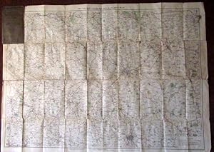
Bacon's Motoring and Cycling Road Map - Nottingham District - Half Inch Series.
Idioma: Inglés
Publicado por G.W. Bacon & Co. Ltd, United Kingdom, 1920
Librería: Winghale Books, South Kelsey, LINCS, Reino Unido
Calificación del vendedor: 5 de 5 estrellas

EUR 4,84
Envío por EUR 21,13
Se envía de Reino Unido a Estados Unidos de AmericaCantidad disponible: 1 disponibles
Ańadir al carritoSoft cover. Condición: Read description. Size (folded) - 18 x 10 cms. Size (unfolded) - 90 x 65 cms. No date but probably early 20th Cent. Covers and rear of map stained - the stain mark is also around the edges of the front idex (a large browning type mark) - a few minor tears to map - see photo. Bacon's Motoring and Cycling Road Map - Nottingham District - Half Inch Series. - no date but probably 1920s/30s?).
-
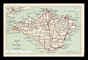
Post card showing a map of the Isle of Wight
Publicado por Edinburgh: G. W. Bacon & Co. Ltd.
Librería: MW Books, New York, NY, Estados Unidos de America
Calificación del vendedor: 5 de 5 estrellas
Original o primera edición
EUR 20,81
Gastos de envío gratis
Se envía dentro de Estados Unidos de AmericaCantidad disponible: 1 disponibles
Ańadir al carritoFirst Edition. One postcard in near fine condition and printed on stiff card paper. Remains well preserved overall; bright and clean. No inscription on the back of the postcard. Physical description; 1 postcard. Notes; No clear date given. Subjects; Isle of Wight. Maps. Postcards. 3 Kg.
-

My Second Atlas: 64 pages in colour containing 61 maps and insets: 190 illustrations with questions: index to place-names
Publicado por Edinburgh & London: W. & A. K. Johnston & G. W. Bacon Ltd., 1961
Librería: MW Books, New York, NY, Estados Unidos de America
Calificación del vendedor: 5 de 5 estrellas
EUR 22,65
Gastos de envío gratis
Se envía dentro de Estados Unidos de AmericaCantidad disponible: 1 disponibles
Ańadir al carritoEnlarged Edition. Good copy bound in quarter cloth over decorated paper boards. So slight wear and tear as with age. Remains well preserved overall; bright and clean. Includes previous owner's inscriptions. Physical description; 64 pages. Notes; No clear publication date given. Subjects; Atlas. Children's Atlas. 3 Kg.
-

Bacon's Motoring and Cycling Road Map England & Wales.
Publicado por G. W. Bacon & Co., Ltd., London, 1930
Librería: Jeffrey H. Marks, Rare Books, ABAA, Rochester, NY, Estados Unidos de America
Miembro de asociación: ABAA ILAB
Calificación del vendedor: 5 de 5 estrellas
EUR 18,04
Envío por EUR 6,57
Se envía dentro de Estados Unidos de AmericaCantidad disponible: 1 disponibles
Ańadir al carritoTinted map, about 28 x 23 inches, backed with linen and folded into 12mo portfolio as issued. publisher's blue lettered cloth. Light use to the cloth portfolio. Index on pastedown.
-
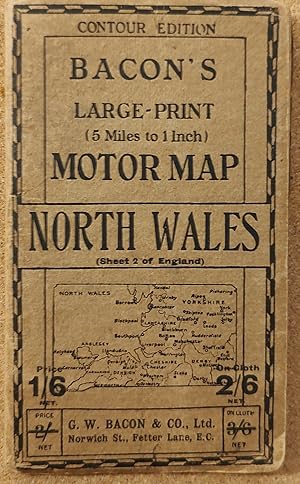
Bacon's Large-print (5 Miles to 1 Inch) Motor Map - North Wales (Sheet 2 of England) CONTOUR EDITION
Publicado por G W Bacon & Co Ltd, 1950
Librería: Shore Books, London, Reino Unido
Calificación del vendedor: 5 de 5 estrellas
Mapa
EUR 12,09
Envío por EUR 12,91
Se envía de Reino Unido a Estados Unidos de AmericaCantidad disponible: 1 disponibles
Ańadir al carritoSoft cover. Condición: Very Good. (SL#19).
-
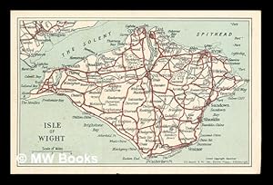
Post card showing a map of the Isle of Wight
Publicado por Edinburgh: G. W. Bacon & Co. Ltd.
Librería: MW Books Ltd., Galway, Irlanda
Calificación del vendedor: 5 de 5 estrellas
Original o primera edición
EUR 10,95
Envío por EUR 13,95
Se envía de Irlanda a Estados Unidos de AmericaCantidad disponible: 1 disponibles
Ańadir al carritoFirst Edition. One postcard in near fine condition and printed on stiff card paper. Remains well preserved overall; bright and clean. No inscription on the back of the postcard. Physical description; 1 postcard. Notes; No clear date given. Subjects; Isle of Wight. Maps. Postcards. 1 Kg.
-

My Second Atlas: 64 pages in colour containing 61 maps and insets: 190 illustrations with questions: index to place-names
Publicado por Edinburgh & London: W. & A. K. Johnston & G. W. Bacon Ltd., 1961
Librería: MW Books Ltd., Galway, Irlanda
Calificación del vendedor: 5 de 5 estrellas
EUR 12,95
Envío por EUR 13,95
Se envía de Irlanda a Estados Unidos de AmericaCantidad disponible: 1 disponibles
Ańadir al carritoEnlarged Edition. Good copy bound in quarter cloth over decorated paper boards. So slight wear and tear as with age. Remains well preserved overall; bright and clean. Includes previous owner's inscriptions. Physical description; 64 pages. Notes; No clear publication date given. Subjects; Atlas. Children's Atlas. 1 Kg.
-
Bacon's Midget Map of Central & West London with Street Index and Visitor's Guide
Idioma: Inglés
Publicado por G.W. Bacon & Co. Ltd., Edinburgh
Librería: Lindenlea Books, Ottawa, ON, Canada
Calificación del vendedor: 5 de 5 estrellas
Mapa
EUR 27,07
Envío por EUR 17,47
Se envía de Canada a Estados Unidos de AmericaCantidad disponible: 1 disponibles
Ańadir al carritoSoft cover. Condición: Very Good Plus. Estado de la sobrecubierta: No DJ. No date stated: map displays "Copyright 1/52". Cardboard covers rubbed along edges and sides of spine, small tear (1/8 inch) on front top edge, corners bowed and creased. Map firmly attached. Overall, very good plus. Map has 3 pinpoint brown spots on underside, map itself is bright and clean.
-
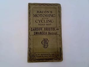
Bacon's Motoring and Cycling Road Map - Cardiff, Bristol and Swansea District
Publicado por G. W. Bacon & Co. Ltd.
Librería: Chapter Two Books, Ammanford, Reino Unido
Calificación del vendedor: 5 de 5 estrellas
EUR 12,08
Envío por EUR 18,77
Se envía de Reino Unido a Estados Unidos de AmericaCantidad disponible: 1 disponibles
Ańadir al carritoCloth. Condición: Good.
-
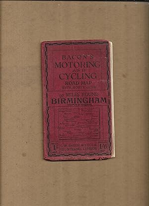
Bacon's motoring and cycling road map with route guide, 50 miles round Birmingham, Sheet8 of England. (Bacon's half-inch maps)
Publicado por G.W. Bacon & Co. Ltd
Librería: Gwyn Tudur Davies, Aberystwyth, Reino Unido
Calificación del vendedor: 5 de 5 estrellas
Mapa
EUR 12,09
Envío por EUR 20,13
Se envía de Reino Unido a Estados Unidos de AmericaCantidad disponible: 1 disponibles
Ańadir al carritoSoft cover. Condición: Good. No Jacket. 1 folded col. map. Covers dulled and creased, some scuffing along folds of map o/w pretty good condition. No publication date [c191-?]. [Maps - Birmingham and district - England] r390 / m14101.
-

Johnston's Motoring and Touring Map of Ireland.
Publicado por W and A K Johnston and G W Bacon ltd.
Librería: High Street Books, New Mills, Reino Unido
Calificación del vendedor: 5 de 5 estrellas
EUR 9,67
Envío por EUR 23,47
Se envía de Reino Unido a Estados Unidos de AmericaCantidad disponible: 1 disponibles
Ańadir al carritoMap. Condición: Good. Covers marked and worn with short tears to the edges, cloth backed map undated.
-
Bacon's Map of the Seat of War in North Sea, Belgium and Eastern France. Scale 18 miles to the inch.
Idioma: Inglés
Publicado por G. W. Bacon & Co. Ltd.
Librería: Kerr & Sons Booksellers ABA, Cartmel, CMA, Reino Unido
Miembro de asociación: ABA ILAB
Calificación del vendedor: 5 de 5 estrellas
Mapa Original o primera edición
EUR 18,13
Envío por EUR 35,21
Se envía de Reino Unido a Estados Unidos de AmericaCantidad disponible: 1 disponibles
Ańadir al carritoSoft cover. Condición: Very Good. 1st Edition. No date, presumed 1st thus. Folding map, cloth-backed. Measures: 82cm x 55cm approx. In card covers. Some rubbing and edge wear. A 'Very Good' copy.
-
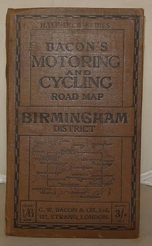
Bacon's Motoring and Cycling Road Map: Birmingham District
Publicado por G. W. Bacon & Co. Ltd., London, 1915
Librería: Besleys Books PBFA, Diss, Reino Unido
Miembro de asociación: PBFA
Calificación del vendedor: 5 de 5 estrellas
EUR 15,72
Envío por EUR 21,13
Se envía de Reino Unido a Estados Unidos de AmericaCantidad disponible: 1 disponibles
Ańadir al carritoHard Cover. Condición: Good. Hardback, folding map measuring 64cm x 89cm. Tear with small loss to 8pp Index of Towns. Map is in good order. A decent copy. (ar18).
-
Bacon's Large Scale Map of the Isle of Wight
Publicado por W. & A.K. Johnston & G.W. Bacon Ltd, London and Edinburgh, 1955
Librería: beckfarmbooks, HOLT, Norfolk, Reino Unido
Calificación del vendedor: 3 de 5 estrellas

EUR 12,09
Envío por EUR 26,41
Se envía de Reino Unido a Estados Unidos de AmericaCantidad disponible: 1 disponibles
Ańadir al carritoCard Covers. Condición: Good Plus. Estado de la sobrecubierta: None. Fold-out map of the Isle of Wight with large index to place names. Map fully coloured (roads in red, woods and parks in green) on a scale of 1 inch to 1 mile. Yellow and green card covers 6.5 x 3.75 inches. Map in 21 sections of the same size. Originally published at 2/- (two shillings).
-
Bacon's Atlas of London
Publicado por Johnston & Bacon, 1963
Librería: Goulds Book Arcade, Sydney, Newtown, Sydney, NSW, Australia
Calificación del vendedor: 5 de 5 estrellas
EUR 23,84
Envío por EUR 21,90
Se envía de Australia a Estados Unidos de AmericaCantidad disponible: 1 disponibles
Ańadir al carritoHardcover. Condición: Good. Estado de la sobrecubierta: No Dust Jacket. The cover has a bit of wear, with a few scuffs and a tear on the bottom spine. The page edges are moderately tanned and foxed. Books listed here are not stored at the shop. Please contact us if you want to pick up a book from Newtown.
-
Bacon's Ruby Map London & Suburbs, Mounted 2/- on Cloth,
Publicado por London; G.W. Bacon Circa 1952, 1952
Librería: Virginia Martin, aka bookwitch, Concord, CA, Estados Unidos de America
Calificación del vendedor: 5 de 5 estrellas
EUR 51,88
Envío por EUR 4,82
Se envía dentro de Estados Unidos de AmericaCantidad disponible: 1 disponibles
Ańadir al carritoSoft cover. Condición: Very Good. No Jacket. 12 mo., green card covers, folding map inside of cardboard, cover scuffed else VG. map folded to small format [6 inches by 3.5] with 32pp index. Gives "strangers guide to London". Book.
-
Bacon's Large Scale Plan Of Woolwich, Including Plumstead, Eltham, Blackheath, Bromley, And Chislehurst In Scale Four Inches To A Mile. Large Folding Map.
Idioma: Inglés
Publicado por G. W. Bacon & Co. Ltd., London.
Librería: James Hine, Ilminster, SOMER, Reino Unido
Miembro de asociación: PBFA
Calificación del vendedor: 4 de 5 estrellas

EUR 60,45
Envío por EUR 41,08
Se envía de Reino Unido a Estados Unidos de AmericaCantidad disponible: 1 disponibles
Ańadir al carritoSoft cover. Condición: Very Good. No Jacket. Large folding coloured map in good condition. Ilustrador. 5th or later Edition. Nd. c. 1910, edition not stated. 11 page alphabetical index to streets of Woolwich and adjacent districts to start. large folded coloured map in very good condition housed in red printed card cover rubbed around spine and edges, light marking, else very good copy.
-
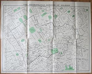
The Metropolitan Borough of Holborn.
Publicado por , 1939, 1939
Librería: Pennymead Books PBFA, Knaresborough, Reino Unido
Miembro de asociación: PBFA
Calificación del vendedor: 5 de 5 estrellas
EUR 26,84
Envío por EUR 17,61
Se envía de Reino Unido a Estados Unidos de AmericaCantidad disponible: 1 disponibles
Ańadir al carritoLithograph, coloured. Scale 1: 2500. Large folding map in fine condition. 39 x 31" Drawn by J.E. Parr Borough Engineer and Surveyor.
-
Bacon's New Survey Map of South Scotland including Counties of Dumbarton, Stirling. (etc) Showing Burghs, Parishes, Railways, Roads, Elevations & Distances.
Publicado por Manchester: G W Bacon c, 1900
Librería: David Ford Books PBFA, Cley-next-the-Sea, Reino Unido
Miembro de asociación: PBFA
Calificación del vendedor: 5 de 5 estrellas
Mapa
EUR 24,18
Envío por EUR 35,21
Se envía de Reino Unido a Estados Unidos de AmericaCantidad disponible: 1 disponibles
Ańadir al carritoCondición: very good. Undated but from style and contents probably c.1900. HB. Purple cloth covers, lettered in gilt to spine and front, protecting large coloured folding map printed on paper laid onto linen, with marbled paper front and back once folded. Folds out to 24 sections. Scale of 3 miles to one inch. Folded size: 24.5 x 21 cm, opening out to 95 x 120 cm. Attractively printed in various colours, (pink, yellow, light orange and green), with a panel devoted to geology map, as well as text panels at sides for Index-Gazetteer. Good condition overall: the map is very good, bright and clean, with slight browning to margins, and the folds are clean and sturdy; there are some light marks to back of linen. The cloth covers are fair only as spine panel is largely lost but the front is very good and with bright gilt of title; creases to back. Other Bacon maps of various counties published at same time in same format available.
-

3-D Seismic Interpretation
Idioma: Inglés
Publicado por Cambridge University Press, 2007
ISBN 10: 0521710669 ISBN 13: 9780521710664
Librería: moluna, Greven, Alemania
Calificación del vendedor: 5 de 5 estrellas
EUR 79,01
Envío por EUR 48,99
Se envía de Alemania a Estados Unidos de AmericaCantidad disponible: 5 disponibles
Ańadir al carritoCondición: New. This book is an indispensable guide for geoscientists using 3-D seismic data, particularly graduate students of geophysics and petroleum geology, and new entrants into the oil and gas industry. This new paperback edition includes up-to-date topics such as e.
-
Francis Bacon 1909-1992 Small Portrait Studies Loan Exhibition.
Publicado por London: 1995., 1995
Librería: D & E LAKE LTD. (ABAC/ILAB), Toronto, ON, Canada
Miembro de asociación: ABAC ILAB
Calificación del vendedor: 3 de 5 estrellas
EUR 60,09
Envío por EUR 13,14
Se envía de Canada a Estados Unidos de AmericaCantidad disponible: 1 disponibles
Ańadir al carritoSoft cover. Condición: Fine. 4to. unpaginated. profusely in colour, some b/w. wrs. Exhibition catalogue.
-

Variety Season: Souvenir Theatre Programme at the London Palladium, Oxford Circus, London
Publicado por Performance Programme Dated July 30th circa . 1947., 1947
Librería: Little Stour Books PBFA Member, Canterbury, Reino Unido
Miembro de asociación: PBFA
Calificación del vendedor: 5 de 5 estrellas
EUR 18,13
Envío por EUR 35,21
Se envía de Reino Unido a Estados Unidos de AmericaCantidad disponible: 1 disponibles
Ańadir al carritoCondición: Very Good. Original stapled colour illustrated souvenir theatre programme 8˝'' x 5˝''. Contains 12 printed pages of text, advertisements and photographs. In Very Good condition. Member of the P.B.F.A. THEATRE PROGRAMMES.
-
25 Miles around Windsor
Publicado por London c.1905, London, 1905
Librería: High Ridge Books, Inc. - ABAA, South Deerfield, MA, Estados Unidos de America
Miembro de asociación: ABAA ESA ILAB SNEAB
Calificación del vendedor: 5 de 5 estrellas
EUR 67,66
Envío por EUR 7,97
Se envía dentro de Estados Unidos de AmericaCantidad disponible: 1 disponibles
Ańadir al carritoFolding map in stiff printed wrappers. 20 pp. text detailing distances along various bicycle routes. Shows the area from London in the east to Oxford at the northwest corner, Basingstoke, Aldershot and Guildford in the south. Defective, lacking most of an 8x15 cm. section at the bottom right, which would include the immediate area around Merstham. Otherwise, the map is in good condition with one repair of a split fold. Main roads and park areas are colored. The front wrapper reads "Bacon's Cycling Road-Map, 40 Miles about Windsor", though the map itself touts only 25 miles around Windsor. The back cover advertises Humber bicycles, touting their ownership by King Edward VII and other members of royal families.
-

Bacon's Cycling Road-Map of England: Sheet No. 6 - Fifty Miles Around London
Publicado por G. W. Bacon & Co. Ltd., London
Librería: Kerr & Sons Booksellers ABA, Cartmel, CMA, Reino Unido
Miembro de asociación: ABA ILAB
Calificación del vendedor: 5 de 5 estrellas
Mapa Original o primera edición
EUR 54,40
Envío por EUR 35,21
Se envía de Reino Unido a Estados Unidos de AmericaCantidad disponible: 1 disponibles
Ańadir al carritoSoft cover. Condición: Very Good. 1st Edition. No date, circa 1930's/40's. Map. Folding. Measures: 75cm x 60cm. Printed on cloth/linen. Coloured. Minor fraying to edges of map. Overall a bright example. Housed in red/maroon cloth pouch with gilt title. Advert for 'The Rover Bicycle' to rear. Some minor discolouration to pouch, corners slightly rubbed and bumped. Overall a Very Good copy.
-

Yorkshire
Publicado por London c. 1895, London, 1895
Librería: High Ridge Books, Inc. - ABAA, South Deerfield, MA, Estados Unidos de America
Miembro de asociación: ABAA ESA ILAB SNEAB
Calificación del vendedor: 5 de 5 estrellas
EUR 90,22
Envío por EUR 7,97
Se envía dentro de Estados Unidos de AmericaCantidad disponible: 1 disponibles
Ańadir al carritoPocket map in original stiff illustrated wrappers. Fine condition. 36 pp. text, with descriptions of each of the towns in Yorkshire. The text is complete, but its signatures have been bound out of order. The map shows the major roads, identifying which are safest for bicycle riding and which have dangerous hills.
-
Bacon s Commercial and Industrial Map of Lancashire: Showing Railways, Roads, Elevations and Distances [Bacon s Excelsior Map of Lancashire]
Publicado por G. W. Bacon & Co. Ltd., Manchester ca. 1880, 1880
Librería: Tiber Books, Cockeysville, MD, Estados Unidos de America
Calificación del vendedor: 4 de 5 estrellas
EUR 112,77
Envío por EUR 4,81
Se envía dentro de Estados Unidos de AmericaCantidad disponible: 1 disponibles
Ańadir al carritoHardcover. Condición: Good. . . . . 8vo, hardcover, maroon cloth. Very large fold-out color map, backed on original linen. Vg condition. Binder faded, though intact, with backstrip possibly replaced. Map itself in very good condition, with no marking or rubbing. A fascinating contemporary look at 19th century England s industrial Midlands.
-

Bacon's Cycling Road-Map of Oxford and District
Publicado por London c. 1900, London, 1900
Librería: High Ridge Books, Inc. - ABAA, South Deerfield, MA, Estados Unidos de America
Miembro de asociación: ABAA ESA ILAB SNEAB
Calificación del vendedor: 5 de 5 estrellas
EUR 112,77
Envío por EUR 7,97
Se envía dentro de Estados Unidos de AmericaCantidad disponible: 1 disponibles
Ańadir al carritoUnbacked folding map in red cloth binding. 16 pp. text lists the bicycle routes. Very good condition, with general wear at extremities of binding. While the title and the routes listed describe an area in an around Oxford, the map shows a large area extending from Birmingham in the northwest to London in the southeast.
-
Francis Bacon. Recent Paintings. March - April 1967.
Librería: Frans Melk Antiquariaat, HILVERSUM, Holanda
Calificación del vendedor: 5 de 5 estrellas
EUR 15,00
Envío por EUR 68,00
Se envía de Holanda a Estados Unidos de AmericaCantidad disponible: 1 disponibles
Ańadir al carritoExh. cat. London (Marlborough Fine Art Ltd.) 1967; 86 pp.; exhibition catalogue with a text in French and English by Michel Leiris, excerpts from interviews by David Sylvester and b/w and colour illustrations of which two fold-outs; softcover; transparant wrapper very tight around cover. [Art / international artist [Buitenlandse Kunstenaars] ].
-
![Imagen del vendedor de [WWI] War Map Issued By The Family Herald & Weekly Star a la venta por RareNonFiction, IOBA](https://pictures.abebooks.com/inventory/md/md30881224048.jpg)
[WWI] War Map Issued By The Family Herald & Weekly Star
Publicado por The Family Herald and Weekly Star, Montreal, Canada, 1918
Librería: RareNonFiction, IOBA, Ladysmith, BC, Canada
Miembro de asociación: IOBA
Calificación del vendedor: 5 de 5 estrellas
Mapa Original o primera edición
EUR 266,14
Envío por EUR 17,51
Se envía de Canada a Estados Unidos de AmericaCantidad disponible: 1 disponibles
Ańadir al carritoMap. Condición: Good. First Edition. This copy bearing the ink stamp of F.R. Swanton of Davis Point, Manitoba. Frederick Swanton served in the 200th (Winnipeg) Battalion, Canadian Expeditionary Force (CEF) during WWI. Illustrated red card covers measure 8.25" x 5.5". Map folds out to 40" by 31". Undated but appears to be circa 1918. Issued as a supplement to Montreal publications The Family Herald and Weekly Star by permission G.W. Bacon & Co. Ltd., 127 Strand, London. Detailed black and white map of Europe presents the setting of World War I, presumably as a reference for Canadians following the progress of the war. Average wear. Several unobtrusive clear tape repairs. A sound vintage copy of this Canadian WWI memento with special noted provenance. Size: Double Elephant - over 25" - 50" tall.
-

Bacon's Library Map of the Environs of London.
Publicado por London G. W. Bacon & Co. Ltd. Norwich Street Fetter Lane EC4. c., 1931
Librería: Robert Frew Ltd. ABA ILAB, London, Reino Unido
Miembro de asociación: ABA ILAB PBFA
Calificación del vendedor: 5 de 5 estrellas
Mapa
EUR 302,23
Envío por EUR 11,74
Se envía de Reino Unido a Estados Unidos de AmericaCantidad disponible: 1 disponibles
Ańadir al carritoMap dimensions 92 x 132 cm (excluding table to right margin), overall dimensions 100 x 149 cm. Large folding map of London and the surrounding regions covering the extents from Hoddesdon down to Reigate and Canvey Island across to Windsor. Bright original colour marking out the counties, boroughs, districts and parishes. The map divided into three mile squares numbered and lettered at the borders, the grid references corresponding to a large index of local authorities found at the right margin. Printed over four conjoined sheets, the whole divided into 28 sections and mounted on linen. Folds into orginal dark green cloth slipcase, gilt lettered to the upper board. Marbled paper to folded end sections on linen verso. The slipcase slightly worn at extremities, one of the lower joints cracked at the upper edge. The map in excellent condition. The Northern Line extension from Clapham Common to Morden (opened 1926) is marked on the map. Park Royal & Twyford Abbey Station on the District (now Piccadilly) Line is also shown, the station was closed in mid 1931. Stations along the eastern extent of the District Line between Barking and Upminster (re-opened 1932), such as Upney and Becontree, are not shown.


