Importe total (1 artículo artículos):
Destino del pedido:

arab bureau cairo (3 resultados)
Ir a los resultados principales
Filtros de búsqueda
Tipo de artículo
- Todos los tipos de productos
- Libros (3)
- Revistas y publicaciones (No hay ningún otro resultado que coincida con este filtro.)
- Cómics (No hay ningún otro resultado que coincida con este filtro.)
- Partituras (No hay ningún otro resultado que coincida con este filtro.)
- Arte, grabados y pósters (No hay ningún otro resultado que coincida con este filtro.)
- Fotografías (No hay ningún otro resultado que coincida con este filtro.)
- Mapas (No hay ningún otro resultado que coincida con este filtro.)
- Manuscritos y coleccionismo de papel (No hay ningún otro resultado que coincida con este filtro.)
Condición Más información
- Nuevo (No hay ningún otro resultado que coincida con este filtro.)
- Como nuevo, Excelente o Muy bueno (No hay ningún otro resultado que coincida con este filtro.)
- Bueno o Aceptable (1)
- Regular o Pobre (No hay ningún otro resultado que coincida con este filtro.)
- Tal como se indica (2)
Encuadernación
- Todas
- Tapa dura (3)
- Tapa blanda (No hay ningún otro resultado que coincida con este filtro.)
Más atributos
- Primera edición (No hay ningún otro resultado que coincida con este filtro.)
- Firmado (No hay ningún otro resultado que coincida con este filtro.)
- Sobrecubierta (No hay ningún otro resultado que coincida con este filtro.)
- Con imágenes (3)
- No impresión bajo demanda (3)
Idioma (2)
Precio
- Cualquier precio
- Menos de EUR 20 (No hay ningún otro resultado que coincida con este filtro.)
- EUR 20 a EUR 45 (No hay ningún otro resultado que coincida con este filtro.)
- Más de EUR 45
Gastos de envío gratis
- Envío gratis a Estados Unidos de America (No hay ningún otro resultado que coincida con este filtro.)
Ubicación del vendedor
Valoración de los vendedores
-
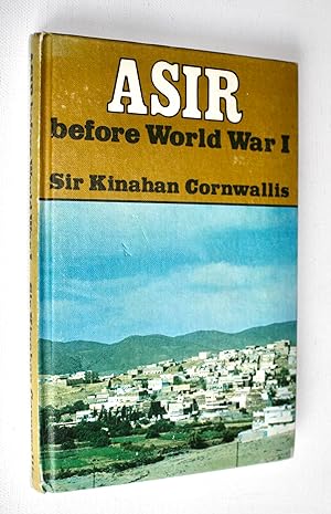
Asir before World War I - A Handbook
Idioma: Inglés
Publicado por Oleander Press; Falcon Press, Cambridge; New York, 1976
ISBN 10: 0902675575 ISBN 13: 9780902675575
Librería: Dendera, London, Reino Unido
Calificación del vendedor: 5 de 5 estrellas

EUR 267,01
Envío por EUR 28,80
Se envía de Reino Unido a Estados Unidos de AmericaCantidad disponible: 1 disponibles
Ańadir al carritoHardcover. Condición: Very Good. Original colour illustrated paper covered boards 14 x 22cm. 155pp including double-page map. Covers very good, bumped to the spine ends, interiors fine. This is a reprint, by permission of the Foreign Office, of Cornwallis' "Handbook to Asir", originally prepared for internal use by the Arab Bureau in Cairo, and published on 1 June 1916. The original Preface states: "This Handbook has been compiled almost entirely from native information obtained recently in Cairo, but gathered originally in Asir itself not later than the outbreak of the present war. there being almost no European literature on Asir of any value, and no European having visited the interiors of the country and furnished a report since the French surgeons and others who accompanied the Egyptian forces in the thirties of the last century". It covers geography, people, manufactures, agriculture, livestock, trade, taxes, history and politics, military organisation, tribal notes, personalities, roads and communications, route reports, etc.
-
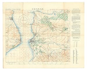
Chanak.
Publicado por Survey Department Egypt,, Cairo,, 1915
Librería: Antiquariaat FORUM BV, Houten, Holanda
Miembro de asociación: ILAB NVVA
Calificación del vendedor: 5 de 5 estrellas
EUR 3.500,00
Envío por EUR 25,00
Se envía de Holanda a Estados Unidos de AmericaCantidad disponible: 1 disponibles
Ańadir al carritoThe finest contemporary map of the Çanakkale sector of the Gallipoli Campaign, the site of the dreaded "Narrows" of the Dardanelles where allied naval forces made their ill-fated attempt to "force the straits" towards taking Istanbul, at a scale of 1:20,000. Drafted in Cairo under the direction of T. E. Lawrence (Lawrence of Arabia) at the Arab Bureau's Intelligence Office, based on a recently captured Ottoman map. The main map image is in black with land contours in brown, waterways in blue, and vegetation in green, with soundings printed in the strait and a grid of parallels and meridians in red (with a note that they are based on a magnetic north). The larger squares (each 5 x 5 smaller squares) are numbered (in a single sequence for the six maps in the series) and the 25 smaller squares designated by letters a-z (without e) - printed only in square 33, so that any 600 x 600 metre square on the map can be specified with coordinates.In the early days of World War I, the British and allied forces sought to knock the Ottoman Empire out of the conflict by taking Constantinople, by way of the Dardanelles. The Gallipoli Campaign (17 February 1915 to 9 January 1916) involved a force of 490,000 British, Indian, Australian, New Zealander and French troops making various landings upon the Gallipoli Peninsula that strategically guarded the mouth of the Dardanelles. The 325,000 Ottoman defenders, backed by German forces, successfully repelled these raids in one of the bloodiest military conflicts in world history.From the outset, the Allies were hampered by a lack of accurate maps of the Gallipoli Peninsula and the adjacent Asian shore of the Dardanelles. They eventually succeeded in capturing a complete six-part set of excellent, newly published Ottoman surveys showing the battle theatre in its entirety. These maps were rushed to the map department of the Intelligence Office (later the famed "Arab Bureau") in Cairo, where they were translated, enlarged and improved by a team headed by Lieutenant T. E. Lawrence, later known as "Lawrence of Arabia". These maps were printed by the Survey Department, Egypt, as a series of six interconnecting maps, although each map was designed to act as a stand-alone work complete in and of itself (a geographic key to all six maps is present on the back of the present map).Overall clean and bright, with some very light stains in the upper-left quadrant and light wear at some fold vertices.l Not in WorldCat. Folded. Colour-lithographed map (79 x 62.5 cm), printed in black, brown, red, blue and green. Mounted on contemporary cloth, with the key on the back (printed on or printed and pasted onto).
-

Chanak.
Publicado por Cairo, Survey Department, Egypt, 1915., 1915
Librería: Antiquariat INLIBRIS Gilhofer Nfg. GmbH, Vienna, A, Austria
Miembro de asociación: ILAB PADA VDA VDAO
Calificación del vendedor: 5 de 5 estrellas
EUR 3.500,00
Envío por EUR 30,00
Se envía de Austria a Estados Unidos de AmericaCantidad disponible: 1 disponibles
Ańadir al carritoColour lithograph, 790 x 625 mm. Mounted on original cloth with maps series key printed on verso. Folded. The finest contemporary map of the Çanakkale sector of the Gallipoli Campaign, the site of the dreaded "Narrows" of the Dardanelles where Allied naval forces made their ill-fated attempt to "force the straits" towards taking Istanbul. Drafted in Cairo under the direction of T. E. Lawrence at the Arab Bureau's Intelligence Office, based on a recently captured Ottoman map. - In the early days of World War I, the Entente sought to knock the Ottoman Empire out of the conflict by taking Constantinople, by way of the Dardanelles. The Gallipoli Campaign (17 February 1915 to 9 January 1916) involved a force of 490,000 British, Indian, Australian, New Zealander and French troops making various landings upon the Gallipoli Peninsula that strategically guarded the mouth of the Dardanelles. The 325,000 Ottoman defenders, backed by German forces, successfully repelled these raids in what was one of the most bloody military contests in world history. - From the outset, the Allies were hampered by a lack of accurate maps of the Gallipoli Peninsula and the adjacent Asian shore of the Dardanelles. They eventually succeeded in capturing a complete six-part set of excellent, newly published Ottoman surveys showing the battle theatre in its entirety. These maps were rushed to the map department of the Intelligence Office (later the famed "Arab Bureau") in Cairo, where they were translated, enlarged and improved by a team headed by Lieutenant T. E. Lawrence, later known as "Lawrence of Arabia". These maps were printed by the Survey Department, Egypt, as a series of six interconnecting maps, although each map was designed to act as a stand-alone work complete in and of itself (a geographic key to all six maps is present on the verso of the present map). - Overall clean and bright, with some very light staining to upper-left quadrant and some light wear at some fold vertices.