
Importe total (1 artículo artículos):
Destino del pedido:

BARRON RODERICK (54 resultados)
Ir a los resultados principales
Filtros de búsqueda
Tipo de artículo
- Todos los tipos de productos
- Libros (53)
- Revistas y publicaciones (No hay ningún otro resultado que coincida con este filtro.)
- Cómics (No hay ningún otro resultado que coincida con este filtro.)
- Partituras (No hay ningún otro resultado que coincida con este filtro.)
- Arte, grabados y pósters (No hay ningún otro resultado que coincida con este filtro.)
- Fotografías (No hay ningún otro resultado que coincida con este filtro.)
- Mapas (1)
- Manuscritos y coleccionismo de papel (No hay ningún otro resultado que coincida con este filtro.)
Condición Más información
Encuadernación
Más atributos
Idioma (4)
Gastos de envío gratis
Ubicación del vendedor
Valoración de los vendedores
-

Mapas del mundo .
Librería: Librería Astarloa, Bilbao, BI, Espańa
Miembro de asociación: AILA ILAB
Calificación del vendedor: 5 de 5 estrellas

EUR 12,00
EUR 21,12 shipping
Se envía de Espańa a Estados Unidos de AmericaCantidad disponible: 1 disponibles
Ańadir al carrito. . . 1 Vol. . 39 láminas pp. Folio Mayor. Rústica. . Contiene ex-libris del anterior propietario. Buen estado.
-
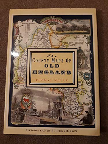
THE COUNTY MAPS OF OLD ENGLAND - Thomas Moule
Idioma: Inglés
Publicado por Studio Editions, London, 1992
ISBN 10: 1851704035 ISBN 13: 9781851704033
Librería: Terra Firma Books, San Diego, CA, Estados Unidos de America
Calificación del vendedor: 5 de 5 estrellas
EUR 13,12
EUR 5,09 shipping
Se envía dentro de Estados Unidos de AmericaCantidad disponible: 2 disponibles
Ańadir al carritoHardcover. Condición: Fine. Estado de la sobrecubierta: Fine. Fine copies of Moule's 56 maps in color from1830; 127pp. No name or writing. CLEAN!
-

EUR 5,99
EUR 12,99 shipping
Se envía de Espańa a Estados Unidos de AmericaCantidad disponible: 1 disponibles
Ańadir al carritoCondición: Muy bueno. : Descubre la fascinante historia de la cartografía con 'Mapas del Mundo' de Roderick Barron. Este libro te lleva en un viaje a través de diferentes periodos, desde el mapa de Hereford hasta los mapas del siglo XIX de John Tallis y Thomas Moule. Con cuarenta láminas a todo color, este volumen ofrece una visión detallada y rica de la evolución de los mapas a lo largo del tiempo. Ideal para amantes de la geografía y la historia. EAN: 9788476300244 Tipo: Libros Categoría: Historia Título: Mapas del mundo Autor: Roderick Barron Editorial: Editorial LIBSA Idioma: es-ES Formato: tapa blanda.
-

Decorative maps
Idioma: Inglés
Publicado por London : Bracken Books, 1989
ISBN 10: 1851702989 ISBN 13: 9781851702985
Librería: MW Books, New York, NY, Estados Unidos de America
Calificación del vendedor: 5 de 5 estrellas
Original o primera edición
EUR 21,97
Gastos de envío gratis
Se envía dentro de Estados Unidos de AmericaCantidad disponible: 1 disponibles
Ańadir al carritoFirst Edition. Near fine paperback copy; wrapper edges very slightly dulled. Remains particularly well-preserved overall; tight, bright, clean and especially sharp-cornered. Physical description: 1 atlas (8 pages, 40 leaves of plates) : color maps ; 38 cm. Notes: Reproduces some plates and originals held by the British Museum and Jonathan Potter Ltd., London. Subjects: Great Britain Maps. Railroads Great Britain Maps. England. History - ; atlases. Genre: Atlas. Language: English. 1 Kg.
-
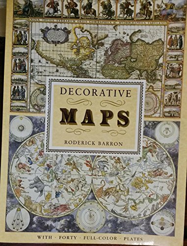
Decorative Maps
Idioma: Inglés
Publicado por Outlet, Avenel, New Jersey, U.S.A., 1989
ISBN 10: 0517688085 ISBN 13: 9780517688083
Librería: Oddball Books, Burbank, CA, Estados Unidos de America
Calificación del vendedor: 5 de 5 estrellas
EUR 8,75
EUR 5,94 shipping
Se envía dentro de Estados Unidos de AmericaCantidad disponible: 1 disponibles
Ańadir al carritoPaperback. Condición: Very Good. Not Stated. The book has some minor wear along the top side edges. Due to the size of this book it cannot be shipped priority mail or outside the United States.
-

Decorative maps
Idioma: Inglés
Publicado por London : Bracken Books, 1989
ISBN 10: 1851702989 ISBN 13: 9781851702985
Librería: MW Books, New York, NY, Estados Unidos de America
Calificación del vendedor: 5 de 5 estrellas
Original o primera edición
EUR 23,75
Gastos de envío gratis
Se envía dentro de Estados Unidos de AmericaCantidad disponible: 1 disponibles
Ańadir al carritoFirst Edition. Very good paperback copy; edges somewhat slightly dust-dulled and nicked. Remains particularly well-preserved overall; tight, bright, clean and strong. Physical description; 8 pages, 40 leaves of plates : color maps ; 39 cm. Subjects; Pictorial maps -- History. Cartography -- History. 1 Kg.
-

Decorative Maps
Idioma: Inglés
Publicado por London : Bracken Books, 1989
ISBN 10: 1851702989 ISBN 13: 9781851702985
Librería: Orbiting Books, Hereford, Reino Unido
Calificación del vendedor: 5 de 5 estrellas
EUR 10,64
EUR 13,77 shipping
Se envía de Reino Unido a Estados Unidos de AmericaCantidad disponible: 1 disponibles
Ańadir al carritopaperback. Condición: Fine. Tanning to edge of pages Appears unread, may have minor superficial marking. Next day dispatch from the UK (Mon-Fri). Please contact us with any queries.
-
The County Maps of Old England
Idioma: Inglés
Publicado por Studio Editions, London, 1990
ISBN 10: 1851704035 ISBN 13: 9781851704033
Librería: Babushka Books & Framers, Isle of Wight, Reino Unido
Calificación del vendedor: 4 de 5 estrellas

Original o primera edición
EUR 7,09
EUR 19,62 shipping
Se envía de Reino Unido a Estados Unidos de AmericaCantidad disponible: 1 disponibles
Ańadir al carritoHardcover. Condición: Very Good. Estado de la sobrecubierta: Very Good. 1st Edition.
-

Decorative maps
Idioma: Inglés
Publicado por London : Bracken Books, 1989
ISBN 10: 1851702989 ISBN 13: 9781851702985
Librería: MW Books Ltd., Galway, Irlanda
Calificación del vendedor: 5 de 5 estrellas
Original o primera edición
EUR 12,95
EUR 13,95 shipping
Se envía de Irlanda a Estados Unidos de AmericaCantidad disponible: 1 disponibles
Ańadir al carritoFirst Edition. Near fine paperback copy; wrapper edges very slightly dulled. Remains particularly well-preserved overall; tight, bright, clean and especially sharp-cornered. Physical description: 1 atlas (8 pages, 40 leaves of plates) : color maps ; 38 cm. Notes: Reproduces some plates and originals held by the British Museum and Jonathan Potter Ltd., London. Subjects: Great Britain Maps. Railroads Great Britain Maps. England. History - ; atlases. Genre: Atlas. Language: English. 1 Kg.
-
Decorative Maps
Librería: Nugget Box (PBFA), Stafford, Reino Unido
Miembro de asociación: PBFA
Calificación del vendedor: 5 de 5 estrellas
EUR 11,82
EUR 16,06 shipping
Se envía de Reino Unido a Estados Unidos de AmericaCantidad disponible: 1 disponibles
Ańadir al carritoPaperback. Condición: Fair. General wear to the book, cover, edges and corners. Slight age discolouration to page edges, small tear/rough edge to bottom corner of 2 pages done in production. Internally Good - clean and tidy copy in tight binding. A Good reference copy. **776g ** All orders are sent with a tracking /signature service for your peace of mind, so that you can keep tabs on your parcel. For overseas customers - on some sites we use, parcels weighing over the standard rate may incur an additional charge and we will then contact you with the additional shipping fee required. This is for the postage only we do not charge you for our time or our excellent packaging, which we are noted for. Dispatched in cardboard mailers within 24/48 Hours Mon - Friday 2pm, except bank holidays, otherwise next business day - excellent service guaranteed. ; 88 pages.
-

Antiche Carte Geografiche
Idioma: Inglés
Publicado por Orsa Maggiore, 1989
Librería: Small World Books, Rochester, NY, Estados Unidos de America
Calificación del vendedor: 2 de 5 estrellas

EUR 22,97
EUR 5,10 shipping
Se envía dentro de Estados Unidos de AmericaCantidad disponible: 1 disponibles
Ańadir al carritoSoft cover. Condición: Very Good. Antique Color Maps Ilustrador. Oversize. Mild Shelfwear And Edgewear, Light Tanning Around Pages' Edges, Otherwise An Unmarkd, Clean, And Solid Copy. No Priority or International Shipping.
-

Decorative Maps
Librería: Neo Books, Sidcup, KENT, Reino Unido
Calificación del vendedor: 5 de 5 estrellas
EUR 9,40
EUR 19,51 shipping
Se envía de Reino Unido a Estados Unidos de AmericaCantidad disponible: 1 disponibles
Ańadir al carritoSoft cover. Condición: Very Good. No Jacket. Some light wear to covers and spine, mainly edges and corners, top right corner of cover lightly creased, internally in good condition, pages crisp and clear.
-

Decorative maps
Idioma: Inglés
Publicado por London : Bracken Books, 1989
ISBN 10: 1851702989 ISBN 13: 9781851702985
Librería: MW Books Ltd., Galway, Irlanda
Calificación del vendedor: 5 de 5 estrellas
Original o primera edición
EUR 14,95
EUR 13,95 shipping
Se envía de Irlanda a Estados Unidos de AmericaCantidad disponible: 1 disponibles
Ańadir al carritoFirst Edition. Very good paperback copy; edges somewhat slightly dust-dulled and nicked. Remains particularly well-preserved overall; tight, bright, clean and strong. Physical description; 8 pages, 40 leaves of plates : color maps ; 39 cm. Subjects; Pictorial maps -- History. Cartography -- History. 1 Kg.
-
Decorative Maps
Idioma: Inglés
Publicado por Crescent Books, Bracken Books, New York, 1989
ISBN 10: 0517688085 ISBN 13: 9780517688083
Librería: Ryde Bookshop Ltd, Isle of Wight, Reino Unido
Calificación del vendedor: 5 de 5 estrellas
EUR 7,09
EUR 22,90 shipping
Se envía de Reino Unido a Estados Unidos de AmericaCantidad disponible: 1 disponibles
Ańadir al carritoSoft cover. Condición: Very Good. with forty full color plates Ilustrador.
-

Decorative Maps
Librería: ACCESSbooks, Gateside, FIFE, Reino Unido
Calificación del vendedor: 5 de 5 estrellas
Original o primera edición
EUR 8,27
EUR 21,80 shipping
Se envía de Reino Unido a Estados Unidos de AmericaCantidad disponible: 1 disponibles
Ańadir al carritoSoft cover. Condición: Near Fine. 1st Edition. Soft cover. Forty full colour plates. No inscriptions, Clean, bright, crisp and tight.
-

Decorative Maps
Idioma: Inglés
Publicado por Studio Editions Ltd, London, 1990
ISBN 10: 1851702989 ISBN 13: 9781851702985
Librería: Washburn Books, Pateley Bridge, Reino Unido
Calificación del vendedor: 5 de 5 estrellas
EUR 6,51
EUR 23,75 shipping
Se envía de Reino Unido a Estados Unidos de AmericaCantidad disponible: 1 disponibles
Ańadir al carritoSoft cover. Condición: Good. No Jacket. Reprint. Volume in the Poster Art Series. Collection of 40 decorative historical maps dated from the middle ages to the 19th century, with introduction and 40 full colour plates, each accompanied by a description. Slight peeling to the laminate cover and minor fading to spine, otherwise good copy with no inscriptions. Size: Folio - over 12 - 15" tall. Book.
-
Decorative Maps with Forty Full-Colour Plates
Idioma: Inglés
Publicado por Crescent Books/Crown Publishers Inc., New York (NY) USA, 1989
ISBN 10: 0517688085 ISBN 13: 9780517688083
Librería: Sarah Zaluckyj, KINGTON, Reino Unido
Calificación del vendedor: 5 de 5 estrellas
EUR 7,09
EUR 24,10 shipping
Se envía de Reino Unido a Estados Unidos de AmericaCantidad disponible: 1 disponibles
Ańadir al carritoSoft cover. Condición: Very Good. Estado de la sobrecubierta: No Dustjacket. 8 pages of text with 40 excellent full-page colour plates. Book has pictorial laminated covers, very slight wear to spine-ends and lower edges, slight wear to corners, slight marks to page-edges. Text is spotless. Very nice condition.
-
The County Maps of Old England.
Idioma: Inglés
Publicado por London; Studio Editions. 1991., 1991
ISBN 10: 1851704035 ISBN 13: 9781851704033
Librería: Elaine Beardsell, HOLMFIRTH, Reino Unido
Miembro de asociación: PBFA
Calificación del vendedor: 4 de 5 estrellas
EUR 17,73
EUR 16,06 shipping
Se envía de Reino Unido a Estados Unidos de AmericaCantidad disponible: 1 disponibles
Ańadir al carritoHardcover. Condición: Fine. Dust Jacket Included. Reprint. 14" x 10". 126[1]pp, illustrated with 56 full plate cold maps. Fine hardback in price clipped, else, fine protected dustwrapper.
-
Mapas del mundo
Idioma: Espańol
Publicado por Libsa, Madrid, 1989
Librería: Librería Raíces, Alicante, Espańa
Calificación del vendedor: 3 de 5 estrellas

EUR 15,00
EUR 16,90 shipping
Se envía de Espańa a Estados Unidos de AmericaCantidad disponible: 1 disponibles
Ańadir al carritoRústica. Condición: Normal. 28 x 38. Cuarenta láminas a todo color. Rústica edit. impresa con mapas y dibujos a color, plastificada.
-
Decorative Maps
Librería: WorldofBooks, Goring-By-Sea, WS, Reino Unido
Calificación del vendedor: 5 de 5 estrellas
EUR 6,60
EUR 6,43 shipping
Se envía de Reino Unido a Estados Unidos de AmericaCantidad disponible: 1 disponibles
Ańadir al carritoPaperback. Condición: Very Good. The book has been read, but is in excellent condition. Pages are intact and not marred by notes or highlighting. The spine remains undamaged.
-
Decorative Maps
Librería: Mooney's bookstore, Den Helder, Holanda
Calificación del vendedor: 4 de 5 estrellas
EUR 28,14
EUR 9,95 shipping
Se envía de Holanda a Estados Unidos de AmericaCantidad disponible: 1 disponibles
Ańadir al carritoCondición: Very good.
-
MAPAS DEL MUNDO. Cuarenta láminas a todo color
Idioma: Espańol
Publicado por Madrid, Libsa, 1989
Librería: LLIBRES del SENDERI, Barcelona, B, Espańa
Calificación del vendedor: 5 de 5 estrellas
EUR 16,00
EUR 18,00 shipping
Se envía de Espańa a Estados Unidos de AmericaCantidad disponible: 1 disponibles
Ańadir al carritoEncuadernación de tapa blanda. Condición: Muy bueno. (Cartografía. Mapas antiguos). Madrid, Libsa, 1989. Col. Poster Art. Cubiertas originales en rústica ilustrada. 8 p. + láminas en color. Folio mayor (38 x 28 cm). Muy buen ejemplar. JL7047.
-
DECORATIVE MAPS
Librería: Richard Sylvanus Williams (Est 1976), WINTERTON, Reino Unido
Calificación del vendedor: 5 de 5 estrellas
EUR 6,94
EUR 34,42 shipping
Se envía de Reino Unido a Estados Unidos de AmericaCantidad disponible: 1 disponibles
Ańadir al carritoPaperback. Condición: VG. Reprint. Book is in very good condition with minor signs of wear and/or age. Large format.
-
COUNTY MAPS OF OLD ENGLAND
Idioma: Inglés
Publicado por Studio Editions, London, 1990
ISBN 10: 1851704035 ISBN 13: 9781851704033
Librería: Amazing Book Company, Liphook, Reino Unido
Calificación del vendedor: 5 de 5 estrellas
EUR 17,73
EUR 25,42 shipping
Se envía de Reino Unido a Estados Unidos de AmericaCantidad disponible: 1 disponibles
Ańadir al carritoHardcover. Condición: New. Estado de la sobrecubierta: As New. Thomas Moule Ilustrador. First Thgus. This copy is in new, unmarked condition bound in blue cloth covered boards with bright gilt titling to the spine. This copy is bright, tight, white and square. The unclipped dust wrapper is in as new condition. International postal rates are calculated on a book weighing 1 Kilo, in cases where the book weighs more than 1 Kilo increased postal rates will be quoted, where the book weighs less then postage will be reduced accordingly. Thomas Moule is one of the most distinctive and beloved of early Victorian mapmakers. His charming series of English county maps, first published in 1830 as the 'English Counties,' are as popular and collectible today as when they first appeared. Their elaborate and decorative style, a synthesis of art and cartography, sets them apart from most other maps of the period, whose plain unembellished style owed much to the pioneering work of the Ordinance Survey. Moule's maps convey a picture of an England where 'ancientness' could still be found in abundance. This was an England where history was still alive in ancient country houses, parish churches with their escutcheoned Gothic memorials and tombs, in market towns and market place and in a landscape that still offered 'scenes, situations, and prospects remarkable fro extent and beauty." Moule is often compared to his distinguished 17th century predecessors, John Speed and Joan Bleau. This new edition of 'Moule's Maps' combines 56 coloured maps with the original text taken from 'Barclays Complete and Universal English Dictionary' in which they appeared in the editions published between 1842 and 1852. Ref DDD 1.
-
The County Maps of Old England
Idioma: Inglés
Publicado por Studio Editions, London, 1990
ISBN 10: 1851704035 ISBN 13: 9781851704033
Librería: Rodney Rogers, Shrewsbury, Reino Unido
Calificación del vendedor: 5 de 5 estrellas
EUR 14,18
EUR 36,90 shipping
Se envía de Reino Unido a Estados Unidos de AmericaCantidad disponible: 1 disponibles
Ańadir al carritoHardcover. Condición: Fine. Estado de la sobrecubierta: Fine. Dark-blue hardcover with gilt lettering to spine, in glossy pictorial dust-jacket. 265 x 362 x 20mm. 127pp. High-quality colour reproductions with text on facing pages. A pristine copy - as new. NB: An extra shipping charge may be requested for heavier or more valuable items. All our 'Seller Images' show the actual item you will receive.
-
Foundations of Analysis With an Introduction to Logic and Set Theory (The Appleton-Century Mathematics Series)
Publicado por Appleton-Century-Crofts, 1971
Librería: BookDepart, Shepherdstown, WV, Estados Unidos de America
Calificación del vendedor: 5 de 5 estrellas
EUR 30,66
EUR 7,17 shipping
Se envía dentro de Estados Unidos de AmericaCantidad disponible: 1 disponibles
Ańadir al carritoHardcover. Condición: Good. Hardcover; fading and light edge wear to exterior; light fading to page edges; in good condition with clean text, firm binding.
-
The county maps of old England
Librería: ACADEMIA Antiquariat an der Universität, Freiburg, Alemania
Miembro de asociación: BOEV
Calificación del vendedor: 5 de 5 estrellas
EUR 32,00
EUR 24,95 shipping
Se envía de Alemania a Estados Unidos de AmericaCantidad disponible: 1 disponibles
Ańadir al carritoGebunden. Condición: Sehr gut. Reprinted. 126 Seiten , pages blaue gebundene Ausgabe im grosen Quartformat (hier: 26 x 36 cm) mit Schutzumschlag; derselbe an Kanten etwas brbrauchsspurig; sonst sehr gutes Exemplar mit zahlr. ganzseitigen farbigen Karten - well-kept hardcover copy with dust jacket and beautiful coloured historical maps of old England Sprache: Englisch Gewicht in Gramm: 1465.
-
Antiche Carte Geografiche.
Publicado por Orsa Maggiore, 1992
Librería: BookScene, Hull, MA, Estados Unidos de America
Calificación del vendedor: 5 de 5 estrellas
EUR 35,00
EUR 4,66 shipping
Se envía dentro de Estados Unidos de AmericaCantidad disponible: 1 disponibles
Ańadir al carritoPaperback. Condición: Good. Paperback. Book Condition: Good. Orsa Maggiore, 1992. 40 pages. Moderate general wear. Size: Folio 12 - 15'' tall. Maps 6280L.
-
Decorative Maps
Idioma: Inglés
Publicado por Published by Bracken Books, London, 1989
ISBN 10: 1851702989 ISBN 13: 9781851702985
Librería: Keoghs Books, Skipton, Reino Unido
Miembro de asociación: PBFA
Calificación del vendedor: 5 de 5 estrellas
Mapa Original o primera edición Ejemplar firmado
EUR 29,55
EUR 32,13 shipping
Se envía de Reino Unido a Estados Unidos de AmericaCantidad disponible: 1 disponibles
Ańadir al carrito, 8 pages of text, plus 40 full colour plates, SIGNED by the author on title page, from the Poster Art series First Edition , book in very good condition 38 x 28 cm Paperback SIGNED by author ISBN: 1851702989.
-
Decorative Maps.
Publicado por Bracken Books, 1989
Librería: Abbey Books, Toronto, ON, Canada
Calificación del vendedor: 5 de 5 estrellas
Original o primera edición
EUR 26,20
EUR 13,59 shipping
Se envía de Canada a Estados Unidos de AmericaCantidad disponible: 1 disponibles
Ańadir al carritoSoft cover. Condición: Fine. 1st Edition. A nice copy.


