Descripción
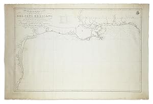
"Broadsheet (26 1/4 x 39 in.; 66.7 x 99.1 cm) on wove paper watermarked " Grimaud/Garcoles," large engraved chart of the northern coastline of the Gulf of Mexico from Cape San Blas on the Gulf coast of Florida to Laguna Madre on the Mexican coast, engraved by Ferdinand Selma after cartographers M. Moreno and J. Morata, wide margins retaining the deckle edges; minor marginal spotting with a few neatly closed tears, IN A REMARKABLE STATE OF PRESERVATION. Loosely laid down on sturdy card and enclosed in mylar. (65B2G) FIRST EDITION OF THE LARGE-SCALE PRINTED CHART OF THE GULF COAST, based on actual soundings and explorations. It was published separately, as here, on the eve of Mexico's fight for independence from Spain, as well as in the "Atlas Maritimo Espanol" (map no. 23 ). Based on "Carta Esferica que comprehende las cóstas del Seno Mexicano" (Madrid, 1799), this chart delineates the Texas coast between the Mississippi and the Rio Grande on a larger scale and with slight revisions. Like the 1799 map, the Carta particular was an improvement over the Jefferys map, which it superseded. It shows the mouth and lower courses of six of the seven most important rivers of Texas. "Here the river entering Galveston Bay is correctly named R. de la Trinidad, instead of R. Archisas, and there is still no Brazos River" (Streeter). "Detailed soundings of all the coastal waterways were given. The Sabine River is shown as the boundary between Texas and Louisiana. The chart is by no means perfect … in spite of relatively minor errors … the continued significance of the map was perhaps best indicated by the fact that nearly twenty years later, in 1825, the first president of the new Republic of Mexico, Guadalupe Victoria, ordered an exact copy printed and distributed" (Martin & Martin). The Dirección de Hidrofgrafia, or the Directorate of Hydrographic Works, was established in 1797. Its roots were in the Casa de Contratación, founded in 1503 in Seville, which housed all the charts of the Spanish Empire and oversaw the creation and maintenance of the padrón real, the official master chart. The Casa, now in Cadiz, was shuttered in 1790, but Spain still needed a hydrographic agency. As a result, the Dirección was created in 1797. One of its first projects was the publication of charts from the Malaspina Expedition (1789-1794). The present chart is scarce, Streeter recorded copies in the Library of Congress, the New York Public Library (as part of the Atlas), the British Library, and his own copy. Worldcat additionally locates copies at Baylor University and the University of Texas at Arlington, and copies at two other continental libraries. In the past thirty years, fewer than a dozen have surfaced at auction or in the trade. REFERENCES: Lowery 744; Martin & Martin, 22B; Phillips, Atlases 4155; Streeter, Bibliography of Texas, Part III, Vol. 1: 1041, cf. 1029 (Carta Esferica, 1799).". N° de ref. del artículo 65ERM0114
Contactar al vendedor
Denunciar este artículo
![]()
