Descripción
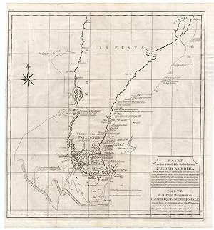
Etching/engraving on a verge type handlaid paper. on paper. Size in cm: The overall size is ca. 50.5 x 54.5 cm. The image size is ca. 49 x 52 cm. Size in inch: The overall size is ca. 19.9 x 21.5 inch. The image size is ca. 19.3 x 20.5 inch.Plate no.8: 'Kaart van het Zuidelykste Gedeelte van Zuider Amerika. - Carte de la partie meridionale de l'Amerique Meridionale.' (Map of the southern part of South-America.) This map shows the route of Capt. George Anson's ship 'The Centurion' down the east coast of South America from St. Catherine's Island off the coast of Brazil, down to Rio de la Plata and the coast of Argentina to Patagonia and Tierra del Fuego (Isle de Terre Fer). Rounding Cape Horn, Anson charted a route up the west coast to Chili and Juan Fernandes Island. This original auhentic plate originates from: 'Reize rondom de werreld, Gedaan in de jaaren 1740 tot 1744, door den Heere George Anson â ¦', 3rd. Ed., published in Leiden and Amsterdam in 1765, translated into Dutch from the 1748 first English ed. by Richard Walter. (A voyage round the world . by George Anson .) Great Britain was at war with Spain in 1740. Admiral of the Fleet George Anson, 1st Baron Anson PC, FRS, RN (1697 -1762) was a British admiral and a wealthy aristocrat, noted for his circumnavigation of the globe and his role overseeing the Royal Navy during the Seven Years' War. Anson commanded the small British squadron sent at the beginning of the war with Spain to harass the Spaniards on the west coast of South America and cut off their supplies of wealth from the Pacific. Disasters and hardships plagued the expedition. most of the ships were lost around Cape Horn, and on the Chilean coast, and of a crew of 960, less than 350 survived. Eventually the Centurion alone was left, but Anson persevered and succeeded in capturing a gold-laden Spanish galleon near Manila. The prize he earned as a result settled his fortune for life. This is the official account of his voyage of circumnavigation, compiled from Anson's journals by Richard Walter, chaplain on board the Centurion, and revised by Benjamin Robins.Artists and Engravers: No engraver or cartographer indicated on this plate. Engravers in the originating work include Jacob Folkema (Dutch 1692-1767), Jakob van der Schley (Dutch 1715-1779) and Frans de Bakker (Dutch 1720-?, fl 1736-1767).Condition: General age related toning and ocassional light soiling. Original fold lines as issued. Ocassional very small tears in paper edges. Light ghosting from text pages of originating work. Please study scan carefullyKeywords: ANTIQUE MAP-SOUTH AMERICA-CHILE-ARGENTINA-LE MAIRE-MAGELLAN STREET-ANSONPCOX-E7-37.
N° de ref. del artículo ab5889
Contactar al vendedor
Denunciar este artículo
