Descripción
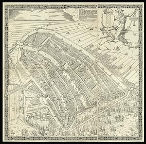
The first printed plan of Amsterdam Large wall map, woodcut with handcut and letterpress lettering on twelve sheets, mounted on linen. Watermark (on several sheets): A yet unidentified foolscap with four pointed extensions and two shorter ones with bells, including an elongated staff with three balls. Not identified in Churchill, Laurentius, Voorn or Heawood. Condition: overall fine condition, untrimmed, and in loose sheets, some sheets a bit darkened in the corners, a few small areas of restoration to margins, perhaps pressed at some stage, apparently once framed (some dark lines in the margins do suggest this), very clean, printed on thin paper. The first printed plan of Amsterdam. Cornelis Anthonisz (1499-c1557) was a distinguished cartographer and painter, and official topographical artist to the Holy Roman Emperor. In 1538 he made a painting of Amsterdam, which he published in 1544, with his monogram and date visible under the letterpress text. It is a bird's eye view taken from an imaginary vantage point over the harbour, looking southwards. Anthonisz' depiction was the source for plans of the city for the next seventy years, while his original blocks remained in circulation for over 110 years; all printings are rare: no example of the original printing of 1544 can currently be located; of this third state, which differs from the second state by the removal of the "Daniel 5. Mene Tekel Phares" in the imprint, Karrow records only four institutional locations. This printing faithfully captures Amsterdam as it was in 1544, before the construction of the outer ring of canals, and celebrates the city's proud maritime heritage, the title supported by a large figure of Poseidon and the foreground dominated by all manner of shipping. The map shows the city of Amsterdam in the early decades of the sixteenth century, facing south, before the construction of the semi-circular ring of canals. It is bordered by the IJ, the Singel, a stretch of river Amstel, in the west and the Kloveniersburgwal and Gelderse Kade in the east. The waterway in the middle is labelled here "Den Amstel" in the South and "Damrack" in the North. The map as such does not only give an impressive view of the topography of the city and its canals and buildings, but it abounds in detail to represent a thriving commercial hub that owes its tremendous wealth to merchants and seafarers, as can be concluded from the number of ships approaching and leaving the port and canals. It is certainly not by accident that this map resembles the famous bird's-eye view of Venice, composed in 1500 by Jacopo de Barbari. The angle at which Amsterdam is shown, the waters and canals dividing the urban districts from each other, and also including an ancient Roman deity such as Neptune, the god of the waters, all imply that Cornelis was familiar with this incredible example of Renaissance printmaking. In any case, it must have suited the commissioners of the original painting, the council of Amsterdam to present their flourishing city as Venice of the North to Charles V and also to those who could afford a print of the map to express their local pride. Cornelis Anthoniszoon's map became famous and very popular soon after it was first published in 1544, so that it continued to be printed in, probably, six editions until the seventeenth century. So far, no example of the first edition is known. We only know of the first edition from an account given by Johann David Passavant in the third part of his book Le Peintre-graveur (1862), where he describes a copy from the private collection of professor Joseph Martin von Reider (1793-1862) in Bamberg/Germany. This map was already untraceable for A.E. d'Ailly in 1934, when he compiled his Catalogus van Amsterdamsche Plattegronden, and it turns out that von Reider's collection was dispersed already from 1858, when von Reider donated major parts of it to the Bavarian state. Today, neither the Staatliche Graphische Sammlung nor the Bayerisches Nat. N° de ref. del artículo 15054
Contactar al vendedor
Denunciar este artículo
![]()
