
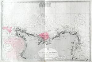
CAPE FLAMANVILLE TO ST. MARCOUF IS. . Detailed sea chart of Cherbourg harbour on the French north coast and its environs, compiled from the latest French Government Charts to 1921. First published by the Admiralty 1888 under the Superintendence of Captain W. J. L. Wharton, and now with small corrections by the
Admiralty Charts.
Editorial: Admiralty 1953
Mapa
Condici�n: Usado - Excelente
Vendido por Garwood & Voigt, Sevenoaks, Reino Unido
Vendedor de AbeBooks desde 25 de noviembre de 2013
Calificaci�n del vendedor: 5 de 5 estrellas
![]()
Usado
Condici�n: Usado - Excelente
Precio:
EUR 117,96
Convertir moneda
EUR 27,49
gastos de env�o desde Reino Unido a Espa�a
Destinos, gastos y plazos de env�o
Cantidad disponible: 1 disponibles
A�adir al carrito