
Importe total (1 artículo artículos):
Destino del pedido:

victoria port phillip antique map de rapkin tallis john (2 resultados)
Comentarios
Autor :
rapkin tallis john
,
Título :
victoria port phillip antique map
Editar en la Búsqueda avanzada
Ir a los resultados principales
Filtros de búsqueda
Tipo de artículo
- Todos los tipos de productos
- Libros (1)
- Revistas y publicaciones (No hay ningún otro resultado que coincida con este filtro.)
- Cómics (No hay ningún otro resultado que coincida con este filtro.)
- Partituras (No hay ningún otro resultado que coincida con este filtro.)
- Arte, grabados y pósters (No hay ningún otro resultado que coincida con este filtro.)
- Fotografías (No hay ningún otro resultado que coincida con este filtro.)
- Mapas (1)
- Manuscritos y coleccionismo de papel (No hay ningún otro resultado que coincida con este filtro.)
Condición Más información
- Nuevo (No hay ningún otro resultado que coincida con este filtro.)
- Como nuevo, Excelente o Muy bueno (No hay ningún otro resultado que coincida con este filtro.)
- Bueno o Aceptable (1)
- Regular o Pobre (No hay ningún otro resultado que coincida con este filtro.)
- Tal como se indica (1)
Encuadernación
- Todas
- Tapa dura (No hay ningún otro resultado que coincida con este filtro.)
- Tapa blanda (No hay ningún otro resultado que coincida con este filtro.)
Más atributos
- Primera edición (No hay ningún otro resultado que coincida con este filtro.)
- Firmado (No hay ningún otro resultado que coincida con este filtro.)
- Sobrecubierta (No hay ningún otro resultado que coincida con este filtro.)
- Con imágenes (2)
- No impresión bajo demanda (2)
Idioma (1)
Precio
- Cualquier precio
- Menos de EUR 20 (No hay ningún otro resultado que coincida con este filtro.)
- EUR 20 a EUR 45 (No hay ningún otro resultado que coincida con este filtro.)
- Más de EUR 45
Gastos de envío gratis
- Envío gratis a Espańa (No hay ningún otro resultado que coincida con este filtro.)
Ubicación del vendedor
Valoración de los vendedores
-
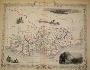
Victoria, or Port Phillip [Antique Map]
Publicado por John Tallis, London, 1851
Librería: Books & Bidders, Cleveland, OH, Estados Unidos de America
Miembro de asociación: IOBA
Calificación del vendedor: 5 de 5 estrellas

Mapa
EUR 83,90
Convertir monedaEUR 17,11 gastos de envío desde Estados Unidos de America a EspańaCantidad disponible: 1 disponibles
Ańadir al carritoCondición: Very Good. [Australia Map]. Original steel engraved map with decorative boarder and vignettes. Map size with central vertical fold is approx. 11 x 14 inches. Antique map of Victoria, or Port Phillip by John Tallis & Company, circa 1851. Vignettes of Melbourne, River Glenelg, Victoria, Kangaroos and Indigenous Peoples. Map drawn and engraved by John Rapkin, with illustrations by A. Warren and engraved by J. Rogers. Contemporary county and state pen outlining in color and pale blue coastline wash. By 1865 Tallis was among the last of the publishers of beautifully decorated hand engraved maps. Shows some expected page toning and light wear at corners. Map.
-
Victoria, or Port Phillip, antique map with vignette views
Publicado por John Tallis & Co., London, 1854
Librería: Antipodean Books, Maps & Prints, ABAA, Garrison, NY, Estados Unidos de America
Miembro de asociación: ABAA ANZAAB ESA ILAB
Calificación del vendedor: 5 de 5 estrellas
EUR 291,43
Convertir monedaEUR 30,65 gastos de envío desde Estados Unidos de America a EspańaCantidad disponible: 1 disponibles
Ańadir al carritoMaps. Steel engraved map from the famous Victorian publisher John Tallis, well-known for the attractive vignette views surrounding the maps, which illustrate the peoples & customs of that region. 10 x 13 1/2" plus margins. Attractive decorative border around edge, period outline color, very good condition.
![Imagen del vendedor de Victoria, or Port Phillip [Antique Map] a la venta por Books & Bidders](https://pictures.abebooks.com/inventory/md/md31800022994.jpg)