Importe total (1 artículo artículos):
Destino del pedido:

sheets stanfords library map london (3 resultados)
Ir a los resultados principales
Filtros de búsqueda
Tipo de artículo
- Todos los tipos de productos
- Libros (2)
- Revistas y publicaciones (No hay ningún otro resultado que coincida con este filtro.)
- Cómics (No hay ningún otro resultado que coincida con este filtro.)
- Partituras (No hay ningún otro resultado que coincida con este filtro.)
- Arte, grabados y pósters (No hay ningún otro resultado que coincida con este filtro.)
- Fotografías (No hay ningún otro resultado que coincida con este filtro.)
- Mapas (1)
- Manuscritos y coleccionismo de papel (No hay ningún otro resultado que coincida con este filtro.)
Condición Más información
- Nuevo (No hay ningún otro resultado que coincida con este filtro.)
- Como nuevo, Excelente o Muy bueno (1)
- Bueno o Aceptable (2)
- Regular o Pobre (No hay ningún otro resultado que coincida con este filtro.)
- Tal como se indica (No hay ningún otro resultado que coincida con este filtro.)
Encuadernación
- Todas
- Tapa dura (No hay ningún otro resultado que coincida con este filtro.)
- Tapa blanda (1)
Más atributos
- Primera edición (No hay ningún otro resultado que coincida con este filtro.)
- Firmado (No hay ningún otro resultado que coincida con este filtro.)
- Sobrecubierta (No hay ningún otro resultado que coincida con este filtro.)
- Con imágenes (2)
- No impresión bajo demanda (3)
Idioma (2)
Precio
- Cualquier precio
- Menos de EUR 20 (No hay ningún otro resultado que coincida con este filtro.)
- EUR 20 a EUR 45 (No hay ningún otro resultado que coincida con este filtro.)
- Más de EUR 45
Gastos de envío gratis
- Envío gratis a Estados Unidos de America (No hay ningún otro resultado que coincida con este filtro.)
Ubicación del vendedor
Valoración de los vendedores
-

Stanford's Library Map of London and Its Suburbs: 24 Sheets, on the Scale of Six Inches to a Mile
Librería: Anybook.com, Lincoln, Reino Unido
Calificación del vendedor: 5 de 5 estrellas

EUR 107,13
Envío por EUR 32,20
Se envía de Reino Unido a Estados Unidos de AmericaCantidad disponible: 1 disponibles
Ańadir al carritoCondición: Good. This is an ex-library book and may have the usual library/used-book markings inside.This book has soft covers. In good all round condition. Please note the Image in this listing is a stock photo and may not match the covers of the actual item,350grams, ISBN:0903541335.
-
Stanford's Library Map of London and it's Suburbs, 24 Sheets, On the Scale of Six Inches to a Mile
Publicado por Harry Margary, Kent, 1980
Librería: Rooke Books PBFA, Bath, Reino Unido
Miembro de asociación: PBFA
Calificación del vendedor: 5 de 5 estrellas
EUR 89,27
Envío por EUR 23,10
Se envía de Reino Unido a Estados Unidos de AmericaCantidad disponible: 1 disponibles
Ańadir al carritoLoose Pages, Articles. Condición: Near Fine. None Ilustrador. A wonderful new edition of Edward Stanford's renowned map of London, featuring introductory notes by Ralph Hyde. A scarce new edition. Unbound, loose and rolled. A smart facsimile of Edward Stanford's important and detailed map of London and it surrounding suburbs. With an introduction by Ralph Hyde. This map was first published in 1862, and was so popular that it is still in print today. Edward Stanford set our to create to most accurate map of London possible, resulting in this brilliantly detailed map, printed across twenty four sheets on a scale of six inches to a mile. Offering a unique insight into Victorian London, during rapid expansion and change in the city due to the Industrial Revolution. Complete with twenty-four sheets of maps. Unbound, loose and rolled. In very smart condition. Pages very bright and clean. Some scattered handling marks to the title sheet and to the reverse of the final map. Some creasing to the lower corner of the final map. Near Fine. book.
-
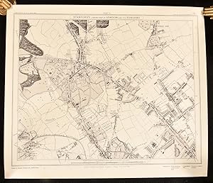
Sheets 19, 20, 23, 24 from Stanford's Library Map of London and its Suburbs including The Crystal Palace near Sydenham
Publicado por Stanford, 1899
Librería: Morning Mist Books and Maps, Cirencester, Reino Unido
Calificación del vendedor: 5 de 5 estrellas
Mapa
EUR 113,08
Envío por EUR 52,00
Se envía de Reino Unido a Estados Unidos de AmericaCantidad disponible: 1 disponibles
Ańadir al carritoNo Binding. Condición: Good. Four conjoined sheets from Standford's great map of London, to a scale of six inches to one mile. This map covers the area from South Norwood (lower left); Herne Hill (upper left); Eastdown Park (upper right); Beckenham Place (lower right). It includes the layout for Crystal Palace, the railways accurately marked, Dulwich Park, key buildings labelled etc. Covers watermarked and stained. Reverse of map with some staining and marking. Map face with some spots and marks. No holes or tears. Map mounted in sections on linen. Undated but handwritten date to front label for 1899. Size when opened: 85.5cm by 67.5cm approx. Further details available on request. (non130med).