Importe total (1 artículo artículos):
Destino del pedido:

rhode island county map (45 resultados)
Ir a los resultados principales
Filtros de búsqueda
Tipo de artículo
- Todos los tipos de productos
- Libros (37)
- Revistas y publicaciones (No hay ningún otro resultado que coincida con este filtro.)
- Cómics (No hay ningún otro resultado que coincida con este filtro.)
- Partituras (No hay ningún otro resultado que coincida con este filtro.)
- Arte, grabados y pósters (No hay ningún otro resultado que coincida con este filtro.)
- Fotografías (No hay ningún otro resultado que coincida con este filtro.)
- Mapas (8)
- Manuscritos y coleccionismo de papel (No hay ningún otro resultado que coincida con este filtro.)
Condición Más información
- Nuevo (No hay ningún otro resultado que coincida con este filtro.)
- Como nuevo, Excelente o Muy bueno (No hay ningún otro resultado que coincida con este filtro.)
- Bueno o Aceptable (9)
- Regular o Pobre (No hay ningún otro resultado que coincida con este filtro.)
- Tal como se indica (36)
Encuadernación
Más atributos
- Primera edición (2)
- Firmado (No hay ningún otro resultado que coincida con este filtro.)
- Sobrecubierta (No hay ningún otro resultado que coincida con este filtro.)
- Con imágenes (39)
- No impresión bajo demanda (45)
Idioma (1)
Gastos de envío gratis
- Envío gratis a Estados Unidos de America (No hay ningún otro resultado que coincida con este filtro.)
Ubicación del vendedor
Valoración de los vendedores
-

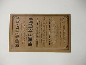
Rand, Mcnally & Co.'s Indexed County And Township Pocket Map And Shippers' Guide Of Rhode Island [ Folded Map]
Publicado por Rand, McNally & Co., Chicago & New York, 1899
Librería: Willis Monie-Books, ABAA, Cooperstown, NY, Estados Unidos de America
Miembro de asociación: ABAA ESA ILAB
Calificación del vendedor: 5 de 5 estrellas

EUR 33,28
Envío por EUR 6,89
Se envía dentro de Estados Unidos de AmericaCantidad disponible: 1 disponibles
Ańadir al carritoSoftcover. Condición: Very Good. Front cover has a very small chip to the upper outer corner. ; Also ".showing in detail the entire railroad system ." Map and twenty pages of text and ads attached to paper covers. Covers approx. 4 1/8" wide by 6 1/2". ; 20 + map pages.
-

Rand McNally & Co.'s Indexed County and Township Pocket Map and Shippers' Guide of Rhode Island Showing All Railways, Cities,Towns, Viliges, Postoffices, Lakes, Rivers, etc. Corrected to Date
Publicado por Rand McNally & Co, Chicago and New York, 1892
Librería: McBlain Books, ABAA, Hamden, CT, Estados Unidos de America
Miembro de asociación: ABAA ILAB SNEAB
Calificación del vendedor: 5 de 5 estrellas
EUR 35,49
Envío por EUR 4,31
Se envía dentro de Estados Unidos de AmericaCantidad disponible: 1 disponibles
Ańadir al carritoPaperback. Condición: Very Good. folding map (inside back cover), 30p. Softcover in original light brown wrapper. 17 cm. Clean copy.
-
Rhode Island Map Hopkinton, Washington County 1870
Publicado por F.W. Beers, Rhode Island, 1870
Librería: biblioboy, North Providence, RI, Estados Unidos de America
Calificación del vendedor: 5 de 5 estrellas
Mapa
EUR 35,49
Envío por EUR 6,03
Se envía dentro de Estados Unidos de AmericaCantidad disponible: 1 disponibles
Ańadir al carritoMap. Condición: Good. F.W. Beers Ilustrador. Original 1870 Rhode Island Map. Hopkinton, Washington County, Rhode Island. Hand colored. The map including margins is 14.5 x 11.75 inches, 14 x 16.5 inches without margins, was taken from the Atlas of the State of Rhode Island and Providence Plantations by F.W. Beers. 1870. The map includes the communities of Barberville, Moscow, Grassy Pond, Rockville, Centreville, Ashville, Hope Valley, Wyoming, Locustville, Hopkinton City, Woodville, Ashaway, Laureldale, Burdickville, Potters Hill and more. On the side of the map is the Ashville Subscribers' Directory- Lafayette Edwards, Manufacturer of Cotton Warps and others. A wonderful, original, antique map. Condition: Light dust soiling and age toning, a tiny light damp stain to the bottom left corner. There is chipping to the margins, not affecting the image. See Photos LRrightE.
-

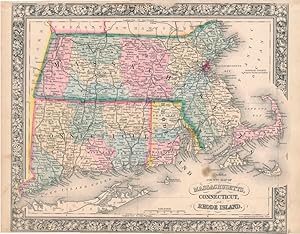
County Map of Massachusetts, Connecticut and Rhode Island
Publicado por Mitchel, S. Augustus, Philadelphia, 1870
Librería: mediumraremaps.com, Franklin, TN, Estados Unidos de America
Calificación del vendedor: 4 de 5 estrellas

Mapa
EUR 48,80
Envío por EUR 5,17
Se envía dentro de Estados Unidos de AmericaCantidad disponible: 1 disponibles
Ańadir al carrito14 x 11 1/4. Condición: Very good. Nice small scale presentation of the three states. Hand colored in outline complemented by wash coloring defining the enclosed counties. Railroad lines dominate the presentation with the coastlines defined in deep dark ink. A fine cartographic presentation of the region.
-
P.J. Hannifan & Co.'s New Commercial Railroad and County Map of Connecticut and Rhode Island and Gazetteer.
Publicado por Buffalo: P.J. Hannifan & Co., 1898
Librería: Centerbridge Books, Old Saybrook, CT, Estados Unidos de America
Calificación del vendedor: 5 de 5 estrellas
EUR 88,73
Envío por EUR 4,31
Se envía dentro de Estados Unidos de AmericaCantidad disponible: 1 disponibles
Ańadir al carritoHardcover. Condición: Good. Printed red cloth. Tall octavo. 496pp. Folding map. Contains numerous engraved ads for businesses in these two states as well as a large color folding map showing townships and railroads. The map measures 24 by 32 inches. A good copy with some rubbing and wear to the covers and some fraying to the spine tips and cover corners. The text is good with some light soiling and wear. The map is in very good condition with minor wear.
-
County Map 0f Massachusetts, Connecticut, and Rhode Island.
Publicado por Philadelphia:, 1870
Librería: Nicholas D. Riccio Rare Books, ABAA, Florham Park, NJ, Estados Unidos de America
Miembro de asociación: ABAA ILAB
Calificación del vendedor: 4 de 5 estrellas
EUR 57,67
Envío por EUR 6,89
Se envía dentro de Estados Unidos de AmericaCantidad disponible: 1 disponibles
Ańadir al carritoUnbound, colored engraved map, decorative boarder, 14"x 11". Slight toning and aging, margins narrow; still bright and clear, and in otherwise good condition. Maps are wrapped with acid free board, or in rigid sleeves. The Mitchell family started to produce atlases in 1846, and continued into the early 1890s. Around 1860, S. Augustus Mitchell Jr. took over, and the atlas would be called Mitchell's New General Atlas. This is an attractive colorful single page map of the states of Massachusetts, Connecticut, and Rhode Island from the 1870 installment of that atlas. Good detail, and Portland is featured in an inset. Ristow 311-313.
-
County Map 0f Massachusetts, Connecticut, and Rhode Island.
Publicado por Philadelphia:, 1869
Librería: Nicholas D. Riccio Rare Books, ABAA, Florham Park, NJ, Estados Unidos de America
Miembro de asociación: ABAA ILAB
Calificación del vendedor: 4 de 5 estrellas
EUR 57,67
Envío por EUR 6,89
Se envía dentro de Estados Unidos de AmericaCantidad disponible: 1 disponibles
Ańadir al carritoUnbound, colored engraved map, decorative boarder, 14"x 11". Slight toning and aging, some margin chips, top margin narrow, and with a couple of chips touching the neat line; still bright and clear, and in otherwise good condition. Maps are wrapped with acid free board, or in rigid sleeves. The Mitchell family started to produce atlases in 1846, and continued into the early 1890s. Around 1860, S. Augustus Mitchell Jr. took over, and the atlas would be called Mitchell's New General Atlas. This is an attractive colorful single page map of the states of Massachusetts, Connecticut, and Rhode Island from the 1869 installment of that atlas. Good detail, and Portland is featured in an inset. Ristow 311-313.
-

County Map of Massachusetts, Connecticut, and Rhode Island
Publicado por S. Augustus Mitchell, Philadelphia, 1867
Librería: mediumraremaps.com, Franklin, TN, Estados Unidos de America
Calificación del vendedor: 4 de 5 estrellas
Mapa
EUR 66,55
Envío por EUR 5,17
Se envía dentro de Estados Unidos de AmericaCantidad disponible: 1 disponibles
Ańadir al carrito13 5/8 x 11 1/2 inches. Condición: very good condition. Three state map showing post Civil War rail networks. Overall a nice presentation of the era of westward expansion with the infilling of interstices of transportation. This map belongs in all collections of the New England States.
-

Commercial Railroad and County Map of Massachusetts and Rhode Island
Publicado por George F. Cram, Chicago, 1899
Librería: mediumraremaps.com, Franklin, TN, Estados Unidos de America
Calificación del vendedor: 4 de 5 estrellas
Mapa
EUR 66,55
Envío por EUR 5,17
Se envía dentro de Estados Unidos de AmericaCantidad disponible: 1 disponibles
Ańadir al carrito24 3/4 x 16 3/4 inches. Condición: Very good. Beautifully executed map showing the railroad network in these two northeastern states. The ports of Boston and Providence have a concentration of railroads. This area was the cradle of early railroad development in the United States. There is a listing and color key to all the railroads. There is also an inset map of Boston. This is a quite decorative antique map.
-

Railroad and County Map of Massachusetts, Connecticut, and Rhode Island
Ańo de publicación: 1885
Librería: Art Source International Inc., Boulder, CO, Estados Unidos de America
Calificación del vendedor: 5 de 5 estrellas
EUR 39,93
Envío por EUR 13,78
Se envía dentro de Estados Unidos de AmericaCantidad disponible: 2 disponibles
Ańadir al carritoThis detailed, double-page map of the states of Massachusetts, Connecticut, and Rhode Island was printed in the "People's Family Atlas of the World," published in 1885. This map, which shows a great deal of topographical information, including lakes, rivers and mountains, has all counties outlined in green and state bounderies outlined in pink. This map measures 20.5 inches by 13.25 inches.
-
County Map of Massachusetts, Connecticut, and Rhode Island
Publicado por S. Augustus Mitchell, Jr., New York, 1862
Librería: Main Street Fine Books & Mss, ABAA, Galena, IL, Estados Unidos de America
Miembro de asociación: ABAA ILAB MWABA
Calificación del vendedor: 5 de 5 estrellas
Mapa
EUR 70,98
Envío por EUR 5,17
Se envía dentro de Estados Unidos de AmericaCantidad disponible: 1 disponibles
Ańadir al carritoFolio (15Ľ" X 12Ľ", image area 14" X 11˝"). Hand colored. Very good. Lightly age toned and faintly soiled ; single small discreet stain. Nice example of this tri-state county map, from the 1864 edition of "Mitchell's New General Atlas, Containing Maps of the Various Countries of the World, Plans of Cities, Etc." Well colored and with sharp floral border.
-
MAP: County Map of the States of New York, New Hampshire, Vermont, Massachusetts, Rhode Island and Connecticut
Publicado por Augustus Mitchell, NY, 1860
Librería: Dorley House Books, Inc., Hagerstown, MD, Estados Unidos de America
Calificación del vendedor: 4 de 5 estrellas
Original o primera edición
EUR 133,09
Envío por EUR 7,45
Se envía dentro de Estados Unidos de AmericaCantidad disponible: 1 disponibles
Ańadir al carritoUnbound. Condición: Very Good. Handcolored Map Ilustrador. 1st. bordered in black & white leaves & grapes design. insets of Harbor and Vicinity of New York & Boston Lovely, and suitable for framing. [2 scans=full image] Size: 15" x 23".
-
County Map of Massachusetts, Connecticut and Rhode Island.
Publicado por Philadelphia:, 1888
Librería: Nicholas D. Riccio Rare Books, ABAA, Florham Park, NJ, Estados Unidos de America
Miembro de asociación: ABAA ILAB
Calificación del vendedor: 4 de 5 estrellas
EUR 75,42
Envío por EUR 6,89
Se envía dentro de Estados Unidos de AmericaCantidad disponible: 1 disponibles
Ańadir al carritoUnbound, colored engraved map, decorative boarder, 23"x 15". Slight toning, darkening and aging in margins, a few nicks along edges; overall bright and clear and in very good shape. Maps are wrapped with acid free board, or in rigid sleeves. This map will be shipped and folded at the original fold. The Mitchell family started to produce atlases in 1846, and continued into the early 1890s. Around 1860, S. Augustus Mitchell Jr. took over, and the atlas would be called Mitchell's New General Atlas. This is a colorful map of the city of three states in New England from the 1888 installment of that atlas. Ristow 311-313.
-
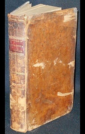
A Gazetteer of the States of Connecticut and Rhode-Island: Written with Care and Impartiality, from Original and Authentic Materials; consisting of Two Parts. I. A Geographical and Statistical Description of Each State . . . II. A General Geographical View of Each County, and Ample Topographical Description and Statistical View of Each Town . . . with an Accurate and Improved Map of Each States; by John C. Pease and John M. Niles
Publicado por William S. Marsh, Hartford, Conn, 1819
Librería: Classic Books and Ephemera, IOBA, Lansdowne, PA, Estados Unidos de America
Miembro de asociación: IOBA
Calificación del vendedor: 5 de 5 estrellas
Original o primera edición
EUR 340,05
Envío por EUR 4,05
Se envía dentro de Estados Unidos de AmericaCantidad disponible: 1 disponibles
Ańadir al carritoHardcover. Condición: Very Good. vii, [1], 389, [1] p., 2 aquatint frontispiece portraits, 2 folded engraved maps; 21 cm. Contemporary full tree calf with six spine compartments between double gilt rules; red leather label in second compartment with gilt-tooled title "Gazetteer of Connecticut & Rhode-Island." All page edges marbled. Bookplate of the Chester County Historical Society on front fixed endpaper, stamped "Duplicate." "Chester County Historical Society" stamped on title page with address. The frontispiece portraits are of Oliver Wolcott, Governor of Connecticutt, and Nehemiah R. Knight, Governor of Rhode Island, both engraved by I. Sanford. Errata on one page following text. Howes, P166; Early American Imprints, ser. 2 (Shaw & Shoemaker), 49034. In Very Good Condition: leather is rubbed and scraped; front joint is starting at head of spine; leather is cracking at head of spine; spine label is intact; lightly browning; occasional foxing; frontispieces have left shadow on facing pages; otherwise clean and tight.
-

County Map of Massachusetts, Connecticut, and Rhode Island
Publicado por S. Augustus Mitchell, Jr., New York, 1862
Librería: Main Street Fine Books & Mss, ABAA, Galena, IL, Estados Unidos de America
Miembro de asociación: ABAA ILAB MWABA
Calificación del vendedor: 5 de 5 estrellas
Mapa
EUR 88,73
Envío por EUR 5,17
Se envía dentro de Estados Unidos de AmericaCantidad disponible: 1 disponibles
Ańadir al carritoFolio (15Ľ" X 12Ľ", image area 14" X 11˝"). Hand colored. Very good. Faint age toning only. Handsome example of this tri-state county map, from the 1864 edition of "Mitchell's New General Atlas, Containing Maps of the Various Countries of the World, Plans of Cities, Etc." Sharp, bright coloring and with handsome decorative border.
-
RAND, MCNALLY & CO'S INDEXED COUNTY AND RAILROAD POCKET MAP AND SHIPPERS' GUIDE OF RHODE ISLAND.
Publicado por Chicago and New York, 1889
Librería: David M. Lesser, ABAA, Woodbridge, CT, Estados Unidos de America
Miembro de asociación: ABAA ESA ILAB SNEAB
Calificación del vendedor: 5 de 5 estrellas
EUR 88,73
Envío por EUR 8,61
Se envía dentro de Estados Unidos de AmericaCantidad disponible: 1 disponibles
Ańadir al carrito4" x 6.5." Original printed wrappers, stitched. 14pp + attractive color folding map at rear. Very Good.
-

County and Township Map of the States of Massachusetts, Connecticut and Rhode Island
Ańo de publicación: 1887
Librería: Art Source International Inc., Boulder, CO, Estados Unidos de America
Calificación del vendedor: 5 de 5 estrellas
EUR 53,24
Envío por EUR 13,78
Se envía dentro de Estados Unidos de AmericaCantidad disponible: 2 disponibles
Ańadir al carritoThis map was made by S. Augustus Mitchell for "Mitchell's New General Atlas" published in 1887. The well maintained maps in this atlas feature Mitchell's characteristic pastel coloring and abundant details of geographical features. Massachusetts, Connecticut and Rhode Island are illustrated on this map. Details include the names of counties, important towns, rivers, mountains, lakes, and railroads. Counties are distinguished by color. These 1887 maps offer a fascinating perspective of areas that have since undergone significant growth and change, in addition to their value as great examples of Mitchell's work. This map has water stains in the margin that do not affect the map. This map measures 21.25 inches by 14.5 inches.
-

County Map of Massachusetts, Connecticut and Rhode Island
Ańo de publicación: 1867
Librería: Art Source International Inc., Boulder, CO, Estados Unidos de America
Calificación del vendedor: 5 de 5 estrellas
EUR 57,67
Envío por EUR 13,78
Se envía dentro de Estados Unidos de AmericaCantidad disponible: 3 disponibles
Ańadir al carritoThe Mitchell company was one of the first to try out the new technique of engraving on steel plates, experimenting with steel almost 20 years before the rest of the publishing industry. He was printing with steel in the early 1830s; the general switch to steel was approximately 1850. During the early years of the company, Mitchell published mainly maps and travel guides. In 1860, Mitchell started producing "Mitchell's New General Atlas",and Mitchell Sr. retired and turned the business over to his son of the same name. The New General Atlas was published until 1893. Today Mitchell maps are sought after for their fine engraving, bright coloring, and attention to detail. They are some of the finest maps produced in the 1860's. This map produced in 1867, has Mitchell's unique floral border, and beautiful hand coloring.This map details the states of County Map of Massachusetts, Connecticut and Rhode Island. Counties, cities, towns, lakes, rivers and transportation routes are noted. This map measures 10.5 inches by 13.5 inches.
-

County and Township Map of the States of Massachusetts, Connecticut, and Rhode Island, 1884
Ańo de publicación: 1884
Librería: Art Source International Inc., Boulder, CO, Estados Unidos de America
Calificación del vendedor: 5 de 5 estrellas
EUR 57,67
Envío por EUR 13,78
Se envía dentro de Estados Unidos de AmericaCantidad disponible: 3 disponibles
Ańadir al carritoThis map was made by S. Augustus Mitchell for "Mitchells New General Atlas" published in 1884, by WM. M. Bradley & Co. The well maintained maps in this atlas feature Mitchell's characteristic pastel coloring and abundant geographical features. Details include the names of counties, cities, towns, transportation routes, rivers, lakes, and mountain ranges. Regions are distinguished by color. These 1884 maps offer a fascinating perspective of areas that have since undergone significant growth and change, in addition to their value as great examples of Mitchell's work. This map measures 21 inches by 14 inches.
-

County and Township Map of the States of Massachusetts Connecticut and Rhode Island
Ańo de publicación: 1881
Librería: Art Source International Inc., Boulder, CO, Estados Unidos de America
Calificación del vendedor: 5 de 5 estrellas
EUR 57,67
Envío por EUR 13,78
Se envía dentro de Estados Unidos de AmericaCantidad disponible: 2 disponibles
Ańadir al carritoThis map came from Mitchells New General Atlas, 1881. The traditional ivy border, and hand coloring make this map beautiful. This double page, US State map shows transportation routes, rivers, towns, and topography features. Very Detailed!' This map measures 21.25 inches by 14.25 inches.
-

County Map of the States of New York, New Hampshire, Vermont, Massachusetts, Rhode Island and Connecticut
Ańo de publicación: 1863
Librería: Art Source International Inc., Boulder, CO, Estados Unidos de America
Calificación del vendedor: 5 de 5 estrellas
EUR 57,67
Envío por EUR 13,78
Se envía dentro de Estados Unidos de AmericaCantidad disponible: 1 disponibles
Ańadir al carritoThe Mitchell company was one of the first to try out the new technique of engraving on steel plates, experimenting with steel almost 20 years before the rest of the publishing industry. He was printing with steel in the early 1830s; the general switch to steel engraving was approximately 1850. During the early years of the company, Mitchell published mainly maps and travel guides. In 1860, Mitchell started producing "Mitchell's New General Atlas". Mitchell Sr. retired and turned the business over to his son of the same name. The New General Atlas was published until 1893. Today Mitchell maps are sought after for their fine engraving, bright coloring, and attention to detail. They are some of the finest maps produced in the 1860's. This map, produced in 1863, shows Mitchell's famous flower border, which is only seen in the early editions of his atlases. This map shows New York, New Hampshire, Vermont, Massachusetts, and Rhode Island. This map measures 22 inches by 17 inches.
-
County Map of the States of New York, New Hampshire, Vermont, Massachusetts, Rhode Island, and Connecticut
Publicado por Philadelphia, 1865
Librería: Nicholas D. Riccio Rare Books, ABAA, Florham Park, NJ, Estados Unidos de America
Miembro de asociación: ABAA ILAB
Calificación del vendedor: 4 de 5 estrellas
EUR 110,91
Envío por EUR 6,89
Se envía dentro de Estados Unidos de AmericaCantidad disponible: 1 disponibles
Ańadir al carritoUnbound, colored engraved map, decorative boarder, 22 1/2"x 14 1/2". Slight toning and aging; overall bright and clear and in very good shape. Maps are wrapped with acid free board, or in rigid sleeves. The Mitchell family started to produce atlases in 1846, and continued into the early 1890s. Around 1860, S. Augustus Mitchell Jr. took over, and the atlas would be called Mitchell's New General Atlas. This is an very attractive and colorful double page map of New York and surrounding states from the 1865 installment of that atlas. While New York is a little less prominent in this version of the map, it is one of the more colorful editions. Boston and New York Harbor are featured in insets. Ristow 311-313.
-

Rhode Island, County Map
Ańo de publicación: 1891
Librería: Art Source International Inc., Boulder, CO, Estados Unidos de America
Calificación del vendedor: 5 de 5 estrellas
EUR 39,93
Envío por EUR 13,78
Se envía dentro de Estados Unidos de AmericaCantidad disponible: 1 disponibles
Ańadir al carritoA very detailed contour map of Rhode Island including the towns of North Smithfield, Woonsocket, Smithfield, Johnston, Cranston, Providence including North and East, and Pawtucket. This highly informative map pays particular attention to major buildings, railroads and mills. This map measures 13 inches by 19 inches.
-

County & Township Map of the States of Massachusetts Connecticut and Rhode Island
Ańo de publicación: 1878
Librería: Art Source International Inc., Boulder, CO, Estados Unidos de America
Calificación del vendedor: 5 de 5 estrellas
EUR 62,11
Envío por EUR 13,78
Se envía dentro de Estados Unidos de AmericaCantidad disponible: 2 disponibles
Ańadir al carritoThis map was produced by Augustus Mitchell in 1878 for his New General Atlas. Highlights of this map are Mitchells traditional grapevine border, characteristic pastel coloring and abundant details of geographical features. The States of Massachusetts, Connecticut and Rhode Island are illustrated on this map. Counties are distinguished by color. This 1878 map offers a fascinating perspective of areas that have since undergone significant growth and change, in addition to the value as great examples of Mitchell's classic mapmaking style. This map measures 21 inches by 14 inches.
-

County Map of Massachusetts, Connecticut and Rhode Island
Ańo de publicación: 1872
Librería: Art Source International Inc., Boulder, CO, Estados Unidos de America
Calificación del vendedor: 5 de 5 estrellas
EUR 62,11
Envío por EUR 13,78
Se envía dentro de Estados Unidos de AmericaCantidad disponible: 3 disponibles
Ańadir al carritohis map was made by S. Augustus Mitchellin 1872. The well maintained maps in this atlas feature Mitchells characteristic pastel coloring and abundant details of geographical features. Massachusetts, Connecticut and Rhode Island are illustrated on this map. Details include the names of counties, important towns, rivers, mountains, lakes, and railroads. Counties are distinguished by color. These 1887 maps offer a fascinating perspective of areas that have since undergone significant growth and change, in addition to their value as great examples of Mitchell's work. This map measures 14 inches by 11.5 inches.
-

County Map of Massachusetts, Connecticut, and Rhode Island
Ańo de publicación: 1863
Librería: Art Source International Inc., Boulder, CO, Estados Unidos de America
Calificación del vendedor: 5 de 5 estrellas
EUR 62,11
Envío por EUR 13,78
Se envía dentro de Estados Unidos de AmericaCantidad disponible: 2 disponibles
Ańadir al carritoThe Mitchell company was one of the first to try out the new technique of engraving on steel plates, experimenting with steel almost 20 years before the rest of the publishing industry. He was printing with steel in the early 1830s; the general switch to steel engraving was approximately 1850. During the early years of the company, Mitchell published mainly maps and travel guides. In 1860, Mitchell started producing "Mitchell's New General Atlas". Mitchell Sr. retired and turned the business over to his son of the same name. The New General Atlas was published until 1893. Today Mitchell maps are sought after for their fine engraving, bright coloring, and attention to detail. They are some of the finest maps produced in the 1860's. This map produced in 1863, shows Mitchell's famous flower border, which is only seen in the early editions of his atlases. This map shows Massachusetts, Connecticut, and Rhode Island. This map measures 14 inches by 12 inches.
-

County and Township Map of the States of Massachusetts Connecticut and Rhode Island, 1888
Ańo de publicación: 1888
Librería: Art Source International Inc., Boulder, CO, Estados Unidos de America
Calificación del vendedor: 5 de 5 estrellas
EUR 62,11
Envío por EUR 13,78
Se envía dentro de Estados Unidos de AmericaCantidad disponible: 2 disponibles
Ańadir al carritoThis map of Massachusetts, Connecticut, and Rhode Island was made by S. Augustus Mitchell for "Mitchells New General Atlas" published in 1888, by WM. M. Bradley & Co. The well maintained maps in this atlas feature Mitchell's characteristic pastel coloring and abundant details of geographical features. Details include the names of counties, cities, towns, transportation routes, mountain ranges, rivers and lakes. These 1888 maps offer a fascinating perspective of areas that have since undergone significant growth and change, in addition to their value as great examples of Mitchell's work. This map measures 21.5 inches by 14 inches.
-

County and Township Map of the States of Massachusetts, Connecticut, and Rhode Island
Ańo de publicación: 1877
Librería: Art Source International Inc., Boulder, CO, Estados Unidos de America
Calificación del vendedor: 5 de 5 estrellas
EUR 62,11
Envío por EUR 13,78
Se envía dentro de Estados Unidos de AmericaCantidad disponible: 1 disponibles
Ańadir al carritoThis hand colored map was made for "Mitchells New General Atlas" published in 1877 by S. Augustus Mitchell. Massachusetts, Connecticut, and Rhode Island are illustrated on this map. Counties are highlighted by color. Other details include the names of counties and important cities, and illustrations of rivers, lakes, and major roads. This map measures 21.5 inches by 14 inches.
-
National Publishing Company's Railroad, Post Office, Township, and County Map of Massachusetts, Rhode Island and Connecticut with Distances in Figures Compiled From the Latest Government and State Surveys and Original Sources.
Publicado por National Publishing Company, Boston, 1902
Librería: Nat DesMarais Rare Books, ABAA, Portland, OR, Estados Unidos de America
Miembro de asociación: ABAA CBA ILAB
Calificación del vendedor: 4 de 5 estrellas
EUR 133,09
Envío por EUR 4,95
Se envía dentro de Estados Unidos de AmericaCantidad disponible: 1 disponibles
Ańadir al carritoLarge color map of the tri-state area; 36 x 38 inches. Linen-backed as issued. Folding into the publisher's brown cloth portfolio with bright gilt lettering and frame. Two corners of the cloth lightly bumped but an excellent copy.
-

Mitchell's 1865 County Map of Massachusetts, Connecticut, and Rhode Island
Ańo de publicación: 1865
Librería: Art Source International Inc., Boulder, CO, Estados Unidos de America
Calificación del vendedor: 5 de 5 estrellas
EUR 66,55
Envío por EUR 13,78
Se envía dentro de Estados Unidos de AmericaCantidad disponible: 2 disponibles
Ańadir al carritoIn 1860 S. Augustus Mitchell Jr. took over his father's map publishing business and in that year he started publishing Mitchell's New General Atlas. Editions of the new general were issued annually until 1887. Mitchell Jr. continued publishing this atlas until 1879. The editions from 1880 to 1887 were published by Wm. M. Bradley. This map published in 1865 is a wonderful example of Mitchell's map-making prowess with beautiful original hand-coloring. This map measures 13.5 inches by 10.5 inches.