
Importe total (1 artículo artículos):
Destino del pedido:

plan rade batavia nautical chart (1 resultados)
Ir a los resultados principales
Filtros de búsqueda
Tipo de artículo
- Todos los tipos de productos
- Libros (No hay ningún otro resultado que coincida con este filtro.)
- Revistas y publicaciones (No hay ningún otro resultado que coincida con este filtro.)
- Cómics (No hay ningún otro resultado que coincida con este filtro.)
- Partituras (No hay ningún otro resultado que coincida con este filtro.)
- Arte, grabados y pósters (No hay ningún otro resultado que coincida con este filtro.)
- Fotografías (No hay ningún otro resultado que coincida con este filtro.)
- Mapas (1)
- Manuscritos y coleccionismo de papel (No hay ningún otro resultado que coincida con este filtro.)
Condición Más información
- Nuevo (No hay ningún otro resultado que coincida con este filtro.)
- Como nuevo, Excelente o Muy bueno (No hay ningún otro resultado que coincida con este filtro.)
- Bueno o Aceptable (No hay ningún otro resultado que coincida con este filtro.)
- Regular o Pobre (No hay ningún otro resultado que coincida con este filtro.)
- Tal como se indica (1)
Encuadernación
- Todas
- Tapa dura (No hay ningún otro resultado que coincida con este filtro.)
- Tapa blanda (No hay ningún otro resultado que coincida con este filtro.)
Más atributos
- Primera edición (No hay ningún otro resultado que coincida con este filtro.)
- Firmado (No hay ningún otro resultado que coincida con este filtro.)
- Sobrecubierta (No hay ningún otro resultado que coincida con este filtro.)
- Con imágenes (1)
- No impresión bajo demanda (1)
Idioma (1)
Precio
- Cualquier precio
- Menos de EUR 20 (No hay ningún otro resultado que coincida con este filtro.)
- EUR 20 a EUR 45 (No hay ningún otro resultado que coincida con este filtro.)
- Más de EUR 45
Gastos de envío gratis
- Envío gratis a Estados Unidos de America (No hay ningún otro resultado que coincida con este filtro.)
Ubicación del vendedor
Valoración de los vendedores
-
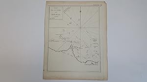
Plan de la Rade de Batavia - a nautical chart showing sea routes into Batavia in the Dutch East Indies with locations of buoys
Publicado por Publisher unknown c1760- 1780, 1760
Librería: Keoghs Books, Skipton, Reino Unido
Miembro de asociación: PBFA
Calificación del vendedor: 5 de 5 estrellas

Mapa
EUR 59,62
Envío por EUR 32,42
Se envía de Reino Unido a Estados Unidos de AmericaCantidad disponible: 1 disponibles
Ańadir al carrito, single unfolded page 28.5 x 22 cms bearing black and white engraved map ( 24 x 18.5 cms ), printed plate XX to top corner with inked 107, this same map is found as plate 107 in Atlas Universelle aus dem Jahre 1787 by Philippe de Pretot but this is a larger version from an unknown publication. There are also copies of this map in Le Petit Atlas maritime recueil de cartes et plans des quatre parties du Monde. Paris: Bellin, 1764, but again they are smaller. , edges to page a little uneven, map in near fine condition 28.5 x 22 cms Map ISBN: