Physical map asia (14 resultados)

- Tapa blanda
- Mapa
Librería: L. Michael, North Hollywood, Estados Unidos de AmericaL. Michael
Contactar con el vendedorVendedor de 4 estrellasCondición: Usado - Excelente
EUR 16,34
Envío por EUR 13,23Se envía dentro de Estados Unidos de AmericaCantidad disponible: 1 disponibles
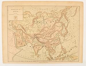
Soft cover. Condición: Fine. Map: Fine/Almost As New/, $25.89 0004490959 ASIA Folding Map. Scale: 1:12 000 000 , 1cm to 120 km, 1 inch to 190 miles, Countries, Stated, Capital Cities, Towns, Physical Features, Roads, Railways, Airports, with Comprehensive Index. Folding Map. * COLLINS Staff Collins 2001 UnKnow Edition S/c Red En…d With Purple Spine And Title In 0ff~White Letters, Soft Cover Map: Fine/Almost As New/, Slight Shelf, Edge And Corner Wear. Clean And Tight To The Spine In As New/ Condition. Remnants Of A Price Sticker, Bottom Rear Cover. D/j: None. This Item Will Be Sent Wrapped In Plastic, Taped Shut And In A = New Padded Mailing Envelope = To Prevent Shipping Damage So That It Will Arrive In The Description Described Which Applies To This Item, = ONLY. = No Odors, No Writing, No Names, No Rippling, Not Stuck Together, No Book Plate, Not X~Library, No Other Marks. = Will Make It, An Excellent Addition To Your Own Personal Library Collection, Or As A Gift, For The Discriminating Reader / Collector. = WORLD WIDE SHIPPING, AVAILABLE *. Map: Fine/Almost As New/, (ilustrador).

Librería: Art Source International Inc., Boulder, Estados Unidos de AmericaArt Source International Inc.
Contactar con el vendedorVendedor de 5 estrellasCondición: Usado
EUR 22,32
Envío por EUR 13,87Se envía dentro de Estados Unidos de AmericaCantidad disponible: 1 disponibles
Añadir al carritoThis chromolithographic map is from Warrens Common-School Geography, printed in 1887. The natural geographical properties of Asia with Europe are given on this map. Details include ocean depths, equatorial currents, products and agriculture, native species of animals, and minerals used for mining. This map measures 11 inches by…9.25 inches.
 Más imágenes
- Mapa
Librería: RareMapsandBooks, Dover, Estados Unidos de AmericaRareMapsandBooks
Contactar con el vendedorVendedor de 4 estrellasCondición: Usado - Aceptable
EUR 24,56
Envío por EUR 6,03Se envía dentro de Estados Unidos de AmericaCantidad disponible: 1 disponibles
Añadir al carritoCondición: good. Asia Fisica.(Old Maps, 20th Century Maps, Middle East, Arabia, Persia, Russia, India, China, Japan, Southeast Asia). Issued 1936, Milan by T. C. Italia. Uncommon large format, over-sized early 20th century color lithograph map from a monumental and uncommon Italian atlas. Colors correspond to elevation heights.…Map displays a profusion of details unique to the era, not normally seen on maps made in other countries around this time. Paper and image remains clean and well preserved with a fine patina and visual appeal. Original center fold as issued. Sheet measures c. 19 1/4 "H x 24" W. Printed area measures c. 17 5/8" H x 20" W.[R33491].

Librería: Art Source International Inc., Boulder, Estados Unidos de AmericaArt Source International Inc.
Contactar con el vendedorVendedor de 5 estrellasCondición: Usado
EUR 26,79
Envío por EUR 13,87Se envía dentro de Estados Unidos de AmericaCantidad disponible: 1 disponibles
Añadir al carritoThis map was made for C.S Hammonds World Atlas in 1936. Machine coloring, primarily in pastels, along with fine detailing and a simple border are among the features of Hammond's maps. Most maps included in this atlas collection illustrate capitals, boundaries, major cities, towns, and transportation details, such as canals, rail…roads and steam ship routes. Maps from this pre World War II time period are difficult to find. This map measures 11 inches by 8 inches.

Editorial: Colton 1856
- Tapa blanda
Librería: Larry W Price Books, Portland, Estados Unidos de AmericaLarry W Price Books
Contactar con el vendedorVendedor de 5 estrellasCondición: Usado - Aceptable
EUR 84,83
Envío por EUR 4,29Se envía dentro de Estados Unidos de AmericaCantidad disponible: 1 disponibles
Añadir al carritoPamphlet. Condición: Good. Map is 18.5 x 16 inches, Elaborate border, Hand-WaterColored in Pastels, light brn waterstain affecting sm area on center bottom margin but not visible within map, else VG & Extremely Attractive & Could be Beautifully Framed (Map is dated 1855).
Editorial: Colton 1856
- Tapa blanda
Librería: Larry W Price Books, Portland, Estados Unidos de AmericaLarry W Price Books
Contactar con el vendedorVendedor de 5 estrellasCondición: Usado - Aceptable
EUR 84,83
Envío por EUR 4,29Se envía dentro de Estados Unidos de AmericaCantidad disponible: 1 disponibles
Añadir al carritoPamphlet. Condición: Good. Map is 18.5 x 16 inches, Elaborate border, Hand-WaterColored in Pastels, light brn toning in small area at bottom right of map but scarcely noticeable, else VG & Extremely Attractive & Could be Beautifully Framed (Map is dated 1855).
Editorial: Harper & Brothers., [New York.] 1875
Librería: Asia Bookroom ANZAAB/ILAB, Canberra, AustraliaAsia Bookroom ANZAAB/ILAB
Contactar con el vendedorVendedor de 5 estrellasCondición: Usado
EUR 47,03
Envío por EUR 26,01Se envía de Australia a Estados Unidos de AmericaCantidad disponible: 1 disponibles
Añadir al carritoMap printed in colour, polar projection, 21 x 27.1 cm, marginal spotting and toning, small edge tears to the inner margin, but in god condition. Prepared for "Harper's School Geography" first published by Harper & Brothers in 1875. The map shows physical features, mountains, steppes, plains, rivers and deserts etc. together with… sources of primary production: whale fisheries, furs, coffe, tea, minerals etc.The verso of the map with references and attractive line engravings, part of the entry for Netherlands and Belgium.

Librería: Art Source International Inc., Boulder, Estados Unidos de AmericaArt Source International Inc.
Contactar con el vendedorVendedor de 5 estrellasCondición: Usado
EUR 49,11
Envío por EUR 13,87Se envía dentro de Estados Unidos de AmericaCantidad disponible: 1 disponibles
Añadir al carritoThis map is from the "Atlas General," published by Louis Etienne Dussieux in 1848. Details include names of lakes and rivers, cities and towns, regions, and topography. Accentuated with hand outline color these steel engraved maps show fine detail and would make an excellent addition to any collection. This map measures 15.25 in…ches by 11 inches.
 Más imágenes
- Mapa
Librería: RareMapsandBooks, Dover, Estados Unidos de AmericaRareMapsandBooks
Contactar con el vendedorVendedor de 4 estrellasCondición: Usado - Aceptable
EUR 42,42
Envío por EUR 6,03Se envía dentro de Estados Unidos de AmericaCantidad disponible: 1 disponibles
Añadir al carritoCondición: good. The Physical Features of Europe & Asia.(Europe, Asia, Arabian Peninsula, Mediterranean Sea, India, China, Japan, Korea, Russia, Persia, Ottoman Empire, Germany, Italy, France, Spain, British Isles, Scandinavia). Issued 1856, Edinburgh by William Blackwood and Sons. Engraved by W & A. K. Johnston. Detailed and lo…vely large mid 19th century color lithographed folio map with piano key border. Numerous cross sectional views of land elevations, including the Dead Sea, Carpathian Mts., Himalayas, etc. Well preserved, nice looking example with pleasing age patina. Original center fold as issued. Sheet Measures c. 21 3/4" H x 27" W. Engraved Area Measures c. 20" H x 24" W. Cartographic Reference (s):Tooley's Dictionary of Mapmakers, vol. 1.[R25240].
 Más imágenes
- Mapa
Librería: RareMapsandBooks, Dover, Estados Unidos de AmericaRareMapsandBooks
Contactar con el vendedorVendedor de 4 estrellasCondición: Usado - Aceptable
EUR 45,54
Envío por EUR 6,03Se envía dentro de Estados Unidos de AmericaCantidad disponible: 1 disponibles
Añadir al carritoCondición: good. The Physical Features of Europe & Asia.(Europe, Asia, Arabian Peninsula, Mediterranean Sea, India, China, Japan, Korea, Russia, Persia, Ottoman Empire, Germany, Italy, France, Spain, British Isles, Scandinavia). Issued 1856, Edinburgh by William Blackwood and Sons. Engraved by W & A. K. Johnston. Detailed, uncom…mon and lovely large (oversized) mid-19th century color lithographed map with piano key border. The bottom is filled with numerous cross-sectional views of land height elevations, including the Dead Sea, Carpathian Mts., Himalayas, etc. Also includes a small and early hand colored (orig.) geological map of the Indonesian island of Java plus a small volcanic kingdom of Luzon Philippines islands map inset. Great scientific thematic map which comes from a scarce and once very expensive elephant folio sheet atlas printed in relatively small numbers for a limited distribution. Well preserved, nice looking example with pleasing age patina. Original center fold as issued. Sheet Measures c. 21 3/4" H x 27" W. Engraved Area Measures c. 20" H x 24" W. Cartographic Reference (s):Tooley's Dictionary of Mapmakers, vol. 1.[R25240-BR125].

Librería: Art Source International Inc., Boulder, Estados Unidos de AmericaArt Source International Inc.
Contactar con el vendedorVendedor de 5 estrellasCondición: Usado
EUR 89,30
Envío por EUR 13,87Se envía dentro de Estados Unidos de AmericaCantidad disponible: 1 disponibles
Añadir al carritoThis physical map was issued as part of J.H. Colton's 1860 School Atlas. This map shows the height of mountains in a unique graph form. Mountain ranges, volcanoes, table lands, and plateaus are denoted. The mean temperatures at midwinter and midsummer are shown as well as the direction of ocean currents. We consider Colton to be… the premier mapmaker in American History. His maps are known for their precision and attention to detail. This map measures 9.75 inches by 12 inches.

Editorial: Lanée Editeur ca. 1885, Paris 1885
- Mapa
Librería: ANTIQUARIAT.WIEN Fine Books & Prints, Wien, AustriaANTIQUARIAT.WIEN Fine Books & Prints
Contactar con el vendedorVendedor de 5 estrellasCondición: Usado
EUR 66,00
Envío por EUR 72,00Se envía de Austria a Estados Unidos de AmericaCantidad disponible: 1 disponibles
Añadir al carritooriginal map, original Landkarte, mehrfärbig, Blatt ca. 32,5 x 42 cm ORIGINAL MAP /ORIGINALE LANDKARTE // Louis Bonnefont, Alexandre Aime? Vuillemin (1812-); Bonacker 232 de 500 Landkarte.
 Más imágenes
- Mapa
Librería: Geographicus Rare Antique Maps, Brooklyn, Estados Unidos de AmericaGeographicus Rare Antique Maps
Contactar con el vendedorVendedor de 4 estrellasCondición: Usado
EUR 750,10
Envío por EUR 14,74Se envía dentro de Estados Unidos de AmericaCantidad disponible: 1 disponibles
Añadir al carritoVery good. Light soiling. Dissected and mounted on linen in thirty-two (32) panels. Size 28.5 x 39 Inches. This is an 1888 Jean Dosseray map of Asia, published at the height of the Great Game. Dosseray's map broadly covers all of Asia. It is titled in French, English, Spanish, and Italian, suggesting he intended it for a pan-Eur…opean audience. Regions are identified by a mix of local and Western names, with tribes referenced in certain areas, suggesting a remarkable level of ethnic sensitivity for the period. Historical Context The late 19th century was a tense era for global relations between the British and the Russians in Central Asia, with both powers continually expanding their 'spheres of influence'. Britain feared Russian advances into Khiva and Bukhara (the yellow region just above Afghanistan). The rail networks in western Russia snaking toward the Caspian Sea and the British rail network expanding north from Calcutta (Kolkata) northwest into the Punjab and the border with Afghanistan reinforce this reality. The Great Game 'The Great Game' was a diplomatic confrontation between the British and Russian Empires over Afghanistan and other territories in Central and Southern Asia. The conflict, rooted in long-standing animosity between Russia and Britain, revolved around Afghanistan, which, while lacking significant resources of its own, was strategically situated. For its part, Russia feared Britain was making commercial and military inroads into Central Asia, an area long within the sphere of influence of St. Petersburg. Britain, conversely, feared Russia making gains in India, 'the jewel in the crown' of British Asia. The escalating tensions led to several wars and proxy wars: The First Anglo-Afghan War (1839 - 1842), the First Anglo-Sikh War (1845 - 1846), the Second Anglo-Sikh War (1848 - 1849), and the Second Anglo-Afghan War (1878 - 1880), along with the Russian annexations of Khiva, Bukhara, and Kokand. Then as now, Afghanistan proved a grinding stone upon which the world's great empires diminished themselves, none achieving a definitive victory despite committing staggering resources. The Great Game 'ended' on September 10, 1895, with the signing of the Pamir Boundary Commission Protocols, which stabilized the border between Afghanistan and the Russian Empire - but well into the 20th century the British were well aware the conflict remained. Regarding the attitude of Afghans to the British and to the Russians, the general assumption of the British was that 'Some will fight for us, some against us, but all will fight.' Publication History and Census This map was created and published by Jean Dosseray in 1888. This is the only known cataloged example.
- Lámina artística
Librería: ThePrintsCollector, Zeeland, HolandaThePrintsCollector
Contactar con el vendedorVendedor de 5 estrellasCondición: Usado
EUR 146,50
Envío por EUR 18,00Se envía de Holanda a Estados Unidos de AmericaCantidad disponible: 1 disponibles
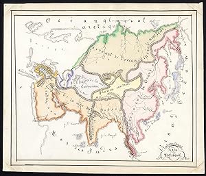
Añadir al carritoAntique manuscript map, titled: 'Asie physique' - A physical map of Asie with China, Japan, India, Arabia and Russia. Indicating mountain ranges and plateaus/highland. Pen and ink drawing, handcoloured, on vellin paper. Description: Source unknown, to be determined. Unique manuscript map. Artists and Engravers: Made by 'Valentin…e Dumont' after own design. This map possibly by Valentine Francoise Dumont (Gent; 1848-1928) a Flemish / Belgian artist, painter of animals (particular donkeys and fowls), sister of Marguerite Dumont. Condition: Good, given age. Remains of attachment to carrier to the corners of the front of the sheet. General age-related toning and/or occasional minor defects from handling. Please study scan carefully. Storage location: TPCRC-C2-27 The overall size is ca. 9 x 8.3 inch. The image size is ca. 8.3 x 7.2 inch. The overall size is ca. 22.8 x 21 cm. The image size is ca. 21 x 18.3 cm.


