
Importe total (1 artículo artículos):
Destino del pedido:

ottoman map world (6 resultados)
Ir a los resultados principales
Filtros de búsqueda
Tipo de artículo
- Todos los tipos de productos
- Libros (6)
- Revistas y publicaciones (No hay ningún otro resultado que coincida con este filtro.)
- Cómics (No hay ningún otro resultado que coincida con este filtro.)
- Partituras (No hay ningún otro resultado que coincida con este filtro.)
- Arte, grabados y pósters (No hay ningún otro resultado que coincida con este filtro.)
- Fotografías (No hay ningún otro resultado que coincida con este filtro.)
- Mapas (No hay ningún otro resultado que coincida con este filtro.)
- Manuscritos y coleccionismo de papel (No hay ningún otro resultado que coincida con este filtro.)
Condición Más información
- Nuevo (1)
- Como nuevo, Excelente o Muy bueno (No hay ningún otro resultado que coincida con este filtro.)
- Bueno o Aceptable (2)
- Regular o Pobre (No hay ningún otro resultado que coincida con este filtro.)
- Tal como se indica (3)
Encuadernación
Más atributos
- Primera edición (No hay ningún otro resultado que coincida con este filtro.)
- Firmado (No hay ningún otro resultado que coincida con este filtro.)
- Sobrecubierta (No hay ningún otro resultado que coincida con este filtro.)
- Con imágenes (5)
- No impresión bajo demanda (6)
Idioma (2)
Precio
- Cualquier precio
- Menos de EUR 20 (No hay ningún otro resultado que coincida con este filtro.)
- EUR 20 a EUR 45
- Más de EUR 45
Gastos de envío gratis
- Envío gratis a Estados Unidos de America (No hay ningún otro resultado que coincida con este filtro.)
Ubicación del vendedor
Valoración de los vendedores
-

Nine-year compulsory education teaching wall charts of the first volume of the history of the world map: the Ottoman Turkish expansion(Chinese Edition)(Old-Used)
Librería: liu xing, Nanjing, JS, China
Calificación del vendedor: 5 de 5 estrellas

EUR 36,04
Envío por EUR 15,48
Se envía de China a Estados Unidos de AmericaCantidad disponible: 1 disponibles
Ańadir al carritopaperback. Condición: Good. Nine-year compulsory education teaching wall charts of the first volume of the history of the world map: the Ottoman Turkish expansion.
-
Cornelius Loos in the Ottoman world: Drawings for the King of Sweden, 1710-1711. [with] Panoramas & map [book]. Prep. by Lâle Uluç, David Jones, Klas Kronberg, Ersu Pekin. 2 volumes set. [BOXED].
Idioma: Inglés
Publicado por Swedish Research Institut in Istanbul / Svenska Forskningsinstitutet Istanbul, Istanbul, 2019
ISBN 10: 9188929000 ISBN 13: 9789188929006
Librería: Khalkedon Rare Books ABA, ILAB, IOBA, ESA, Istanbul, Turquia
Miembro de asociación: ABA ESA ILAB IOBA
Calificación del vendedor: 5 de 5 estrellas
EUR 354,43
Envío por EUR 18,00
Se envía de Turquia a Estados Unidos de AmericaCantidad disponible: 1 disponibles
Ańadir al carritoHardcover. Condición: New. Original bdg. In publisher's special box. Folio. (33 x 29 cm). In English. 2 volumes set: (240 p., 5 unnumbered folded plates on pages; Second volume is a hard-case including two reprint panoramas and one reprint map: First panorama is a huge hand-coloured drawing shows Ottoman Palace across Sarayburnu; size 28x336 cm; Second panorama is a huge hand-coloured drawing shows Ottoman Palace across Sarayburnu again which is indicating Palace from a different angle; size 28x196 cm; and one map: 'Carta ufwer Orienten Med de Darom kring Grantzande Lander. (Turkey and its around map printed originally in early 18th century), descriptive text surrounding the map, size 65x85 cm. Cornelius Loos in the Ottoman world: Drawings for the King of Sweden, 1710-1711. [with] Panoramas & map [book]. Prep. by Lâle Uluç, David Jones, Klas Kronberg, Ersu Pekin. 2 volumes. [BOXED]. Cornelius Loos was one of the young military officers who followed Karl XII to the Ottoman Empire in 1709. From the royal headquarters in what is at present the republic of Moldova, Loos was sent to Istanbul on the King's orders in 1710. From there his journey was pursued by boat over the Mediterranean to Egypt and he returned by land through Jerusalem, Damascus, Aleppo, Konya and Izmir. Loos' mission was to make drawings of the "rarities and monuments" that he would encounter on his journey. Out of the drawings that have survived until today, one is from Palmyra, two from Rhodes and Bodrum and around forty aquarelle tush drawings from Istanbul. It is possible that part of the original drawings were destroyed in the "Skirmish at Bender" in 1713, while other works, due to various reasons, disappeared on their way to Sweden. The conserved drawings are kept at the Swedish National Museum and were exhibited there in 1985. (See catalogue titled "Cornelius Loos. Teckningar frĺn en expedition till Främre Orienten 1719-1711", Stockholm, Nationalmuseum, 1985). The drawings represent a unique record of the urban landscape and the monuments in Istanbul in the early 18th century. The collection includes three great panoramas of the city seen from the Topkapi palace to the upper part of the Golden Horn. To the Loos paintings can be added the great Mecca painting brought to Sweden by Mikael Eneman and kept in the Uppsala University Library, and a small group of oil paintings brought back by Loos' travel companion Conrad Sparre, which are also kept in the art collection of Uppsala University. In addition there are travel accounts and correspondence from these journeys. (From the 'SRII's official site, Karin Adahl's project). "In January 1710 the Swedish king Charles XII, in exile in the Ottoman Empire, sent three of his officers on a journey from the royal camp near Bender in Moldova to travel to Constantinople and from there along the Eastern Mediterranean to Egypt. Their mission was 'to view the there existing rarities and monuments, to draw and to measure'. Cornelius Loos, one of the young officers, returned to his king in 1711 with more than 250 drawings. Only forty-nine, kept under the king's bed, survived a skirmish in the camp in 1713, the so called 'kalabalik' at Bender. King Charles had a vision to publish an encyclopaedic work about the Near East, a dream that was lost in the fire in the camp. The drawings were brought to Sweden when the king returned from the Ottoman Empire in 1714. He died in battle in Norway in 1718. Loos' drawings are unique documents of Constanttinople in the early 18th century, with large scale, detailed panoramas, important prospects of the interior of the Hagia Sophia and views from the Ottoman city. A big map is accompanied by minor drawings from the Black Sea, the Eastern Mediterranean and Egypt, as well as a spectacular set of water-colours of head dresses from the Ottoman world. The Loos collection of drawings is today kept in the National Museum in Stockholm.". Texts by Göran Baarnhielm, Ulla Ehrensvard, Nurhan Atasoy, Günsel Renda, Bo Lundstörm,
-

OTTOMAN WORLD WAR I NAVAL BATTLE MAP Bombardment of Hartlepool, 16th December 1914 A rare and intriguing contemporary map of the raid on Scarborough, Hartlepool and Whitby on December 1914, which was a prelude for the Battle of Dogger Bank (1915), one of the most important naval battles of World War I, was printed in Ottoman script.
Publicado por [Probably Istanbul]. Circa 1915, 1915
Librería: PROCTOR / THE ANTIQUE MAP & BOOKSHOP, DORCHESTER, Reino Unido
Miembro de asociación: PBFA
Calificación del vendedor: 5 de 5 estrellas
EUR 23,75
Envío por EUR 23,06
Se envía de Reino Unido a Estados Unidos de AmericaCantidad disponible: 1 disponibles
Ańadir al carritoLithograph on thick paper map surface approx 24.5 x 22 cm (9.5 x 8.75 inches). In very good condition. With centre fold. Map lightly tanned. Light crease top corner. Else a clean example. This intriguing map was printed in Ottoman script, shortly after the Battle of Dogger Bank (January 24, 1915), a consequential naval altercation between Britain?s Royal Navy and the German Kaiserlichen Marine, during the early period of World War I. It showcases the prelude of the battle, when on December 16, 1914, following the the British success at the Battle of Heligoland Bight (here showcased on the right-hand side), the German Navy approached the British coast and in the morning of December 16 attacked killing 108 and wounding 525 civilians in the raid on Scarborough, Hartlepool and Whitby.
-

Ottoman map of the world.
Publicado por N. p., ca. 1868., 1868
Librería: Antiquariat INLIBRIS Gilhofer Nfg. GmbH, Vienna, A, Austria
Miembro de asociación: ILAB VDA VDAO
Calificación del vendedor: 5 de 5 estrellas
EUR 2.000,00
Envío por EUR 30,00
Se envía de Austria a Estados Unidos de AmericaCantidad disponible: 1 disponibles
Ańadir al carritoColour lithograph and stencil hand-colour. 335 x 420 mm. This uncommon Ottoman map, printed in black and blue, with original hand colour, shows the world in Mercator projection. The Ottoman Turkish alphabet was used until 1928. - Small tears in margins, with a soft fold, but in very good condition.
-
![Imagen del vendedor de OTTOMAN WORLD WAR I NAVAL BATTLE MAP [Raid on Scarborough, Hartlepool and Whitby] A rare and intriguing contemporary map of the raid on Scarborough, Hartlepool and Whitby on December 1914, which was a prelude for the Battle of Dogger Bank (1915), one of the most important naval battles of World War I, was printed in Ottoman script. a la venta por PROCTOR / THE ANTIQUE MAP & BOOKSHOP](https://pictures.abebooks.com/inventory/md/md31677096343.jpg)
OTTOMAN WORLD WAR I NAVAL BATTLE MAP [Raid on Scarborough, Hartlepool and Whitby] A rare and intriguing contemporary map of the raid on Scarborough, Hartlepool and Whitby on December 1914, which was a prelude for the Battle of Dogger Bank (1915), one of the most important naval battles of World War I, was printed in Ottoman script.
Publicado por [Probably Istanbul]. Circa 1915, 1915
Librería: PROCTOR / THE ANTIQUE MAP & BOOKSHOP, DORCHESTER, Reino Unido
Miembro de asociación: PBFA
Calificación del vendedor: 5 de 5 estrellas
EUR 91,44
Envío por EUR 23,06
Se envía de Reino Unido a Estados Unidos de AmericaCantidad disponible: 1 disponibles
Ańadir al carritoLithograph on thick paper Large map surface approx 42.5 x 40 cm (16.5 x 15.8 inches). In very good condition. A number of folds. Map lightly tanned. Else a clean example. This intriguing map was printed in Ottoman script, shortly after the Battle of Dogger Bank (January 24, 1915), a consequential naval altercation between Britain?s Royal Navy and the German Kaiserlichen Marine, during the early period of World War I. It showcases the prelude of the battle, when on December 16, 1914, following the the British success at the Battle of Heligoland Bight (here showcased on the right-hand side), the German Navy approached the British coast and in the morning of December 16 attacked killing 108 and wounding 525 civilians in the raid on Scarborough, Hartlepool and Whitby.
-
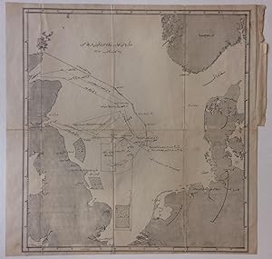
Battle of Dogger Bank - January 24, 1915; Ottoman World War I Military Map
Librería: Argosy Book Store, ABAA, ILAB, New York, NY, Estados Unidos de America
Miembro de asociación: ABAA ILAB
Calificación del vendedor: 5 de 5 estrellas
EUR 350,00
Envío por EUR 5,16
Se envía dentro de Estados Unidos de AmericaCantidad disponible: 1 disponibles
Ańadir al carritounbound. Condición: very good. Map. Lithograph. 16.75 x 16.75 inches. In very good condition. Some wear along original fold lines. Some light staining at top right. Printed circa 1915. A Turkish (Ottoman) map of the North Sea that illustrates the Battle of Dogger Bank, a significant early battle between the British and German navies. After a difficult defeat the month prior, British spies intercepted and decoded German wireless transmissions leading to an important victory.

![Imagen del vendedor de Cornelius Loos in the Ottoman world: Drawings for the King of Sweden, 1710-1711. [with] Panoramas & map [book]. Prep. by Lâle Uluç, David Jones, Klas Kronberg, Ersu Pekin. 2 volumes set. [BOXED]. a la venta por Khalkedon Rare Books ABA, ILAB, IOBA, ESA](https://pictures.abebooks.com/inventory/md/md30358712320.jpg)