Océano: mapas (16 resultados)

- Mapa
Librería: LIBRERIA IL TEMPO CHE FU, Enna, EN, ItaliaLIBRERIA IL TEMPO CHE FU
Contactar con el vendedorVendedor de 5 estrellasCondición: Usado - Excelente
EUR 26,00
Envío por EUR 8,50Se envía de Italia a Estados Unidos de AmericaCantidad disponible: 1 disponibles
Condición: Ottimo. Grande litografia stampata su carta speciale Estratta da una ristampa anastatica del 1992 Incisione del XVI secolo raffigurante il Maris Pacifici (quod vulgo Mar del Zur), la prima carta a stampa interamente dedicata all'Oceano Pacifico, tratta dal Theatrum Orbis Terrarum di Abraham Ortelius, pubblicato ad Anv…ersa nel 1595. La mappa mostra le coste occidentali delle Americhe, dall'Alaska al Cile, insieme all'Asia orientale, alle Filippine, al Giappone e a numerose isole oceaniche, tra cui le Molucche e parte della Nuova Guinea, riflettendo le conoscenze geografiche acquisite dalle spedizioni spagnole e portoghesi del XVI secolo. Particolarmente significativa è la rappresentazione del viaggio di Ferdinando Magellano, con la rotta che attraversa lo stretto a lui intitolato e si apre verso l'immensità del Pacifico, allora chiamato "Mare del Sud". La carta è arricchita da cartigli decorativi, navi e mostri marini, elementi che uniscono rigore scientifico e immaginario rinascimentale. Ortelius, nato ad Anversa nel 1527, fu il primo cartografo a raccogliere e uniformare in un'unica opera le migliori carte disponibili, creando un atlante che offriva al lettore una visione sistematica e coerente del mondo conosciuto. Il Theatrum Orbis Terrarum, stampato per la prima volta nel 1570 dall'editore Gilles Coppens de Diest e successivamente ampliato e ripubblicato fino agli inizi del XVII secolo, è considerato il primo atlante moderno perché per la prima volta le carte furono raccolte in un formato uniforme, corredate da testi esplicativi e organizzate in un corpus coerente. L'opera ebbe un successo straordinario, con oltre quaranta edizioni in diverse lingue, e divenne uno strumento fondamentale per studiosi, mercanti e viaggiatori dell'Europa moderna. Questa tavola, con la sua capacità di illustrare l'Oceano Pacifico e le nuove terre scoperte, è quindi non solo un documento cartografico di grande interesse ma anche una testimonianza diretta della rivoluzione culturale e scientifica che portò alla nascita della cartografia moderna, ideale per collezionisti, studiosi e bibliofili. Dimensioni: Cm 57,00 x 44,00 Codice prodotto: Litografie - 2697 PayPal Carta di credito Bonifico bancario Inserita dentro plico di adeguate dimensioni per proteggerne l'integrità Spedizione con posta ordinaria o raccomandata scelta dall'Acquirente nel momento del pagamento Clicca qui per accedere al nostro Store ed al suo sterminato archivio Litografie - 2697.

Editorial: Paris 1764
- Tapa blanda
- Mapa
Librería: Bolivar Old Prints Anticuario, Barcelona, B, EspañaBolivar Old Prints Anticuario
Contactar con el vendedorVendedor de 5 estrellasCondición: Usado - Bueno
EUR 320,00
Envío por EUR 25,00Se envía de España a Estados Unidos de AmericaCantidad disponible: 1 disponibles
Condición: Bueno. Mapa detallado de la "Bahía de Guayaquil". En el mapa vemos representada la zona próxima a la Isla Puná, así como la desembocadura del Río Guayas al Océano Pacífico. Mapa en francés, pero publicado en el año 1764 por Jacques Nicolas Bellin quien fue un cartógrafo e hidrógrafo francés, reconocido por su trabajo…en la cartografía náutica. Fue el cartógrafo principal del Dépôt des cartes et plans de la Marine y produjo numerosos mapas detallados de costas y territorios coloniales franceses. Entre sus obras más importantes destacan el "Atlas Maritime" (1764) y el "Petit Atlas Maritime" (1764), que contenían mapas precisos de América, África y Asia. Sus trabajos fueron utilizados por navegantes y exploradores, consolidando su prestigio en la cartografía del siglo XVIII. Bellin se destacó por la precisión y calidad de sus mapas, los cuales influenciaron la cartografía europea. A lo largo del mapa podemos ver diferentes referencias náuticas de sondas sobre todo entre la zona costera de la Isla Puná y el continente Sudamericano. Cabe destacar la aparición de la ciudad de Guayaquil al norte del mapa, así como la ciudad Puná en la isla homónima y El Morro. Mapa de pequeñas dimensiones, pero elegante e ilustrativo de la zona sur del litoral ecuatoriano. Condición Muy buena, con una marca de plegado.Carte de la Baye de Guajaquil Palabras clave: "Ecuador", "Guayaquil", "Isla Puná", "El Morro", "Náutico". Idioma: Francés.

Editorial: London 1810
- Tapa blanda
- Mapa
Librería: Bolivar Old Prints Anticuario, Barcelona, B, EspañaBolivar Old Prints Anticuario
Contactar con el vendedorVendedor de 5 estrellasCondición: Usado - Bueno
EUR 420,00
Envío por EUR 25,00Se envía de España a Estados Unidos de AmericaCantidad disponible: 1 disponibles
Condición: Bueno. 59,5 x 86cm. Mapa náutico de grandes dimensiones de la zona meridional del Océano Atlántico. El mapa fue publicado por José de Espinos en el año 1810 en Londres. José de Espinosa y Tello (1763-1815) fue un marino y cartógrafo español destacado en la exploración del Pacífico. Participó en la expedición de Alejan…dro Malaspina (1789-1794), donde recopiló valiosa información náutica y geográfica. Fue clave en la publicación del Atlas de la América septentrional y otros estudios cartográficos. Como director de la Depósito Hidrográfico de la Marina, impulsó la cartografía naval en España. En el mapa se muestra la costa al sur de la línea equinoccial del ecuador hasta el mar del Antártico, así como parte de la costa africana entre el Rio Gabón (Gabón) y el cabo de Buena Esperanza (Sudáfrica). Además, se incluye parte del océano pacifico donde podemos ver incluso la Isla Galápagos representada en el mismo. El mapa se centra principalmente en las zonas costeras así que vemos representados las ciudades y elementos naturales más importantes que se encuentran próximos al litoral. En cuanto a las ciudades más importantes que podemos encontrar tenemos: Quito, Guayaquil, Trujillo, Lima, Arica, Valparaíso, Santiago, Concepción, Buenos Aires, Montevideo, Maldonado, Saõ Paulo, y Rio de Janeiro entre muchas otras. Además, podemos ver representados elementos naturales tan importantes como el Estrecho de Magallanes, el Golfo de San Jorge, las Islas Malvinas y Río de La Plata. Este último tiene un apartado exclusivo en la parte inferior derecha del mapa puesto que encontramos otro mapa, pero en este caso de la zona litoral norte de Rio de La Plata. En este mapa encontramos las ciudades uruguayas de Montevideo y Maldonado entre otros elementos e indicaciones náuticas. Las dimensiones del mapa son de 59.5 x 86 cmCondición Muy buena, con una marca de plegado.Carta General del Océano Atlántico MeridionalPalabras clave: "Atlántico", "Sudamérica", "Dirección hidrográfica de Madrid", "Náutico"." Español.

Editorial: Paris 1605
- Mapa
Librería: Clive A. Burden Ltd., Chalfont St. Giles, BUCKS, Reino UnidoClive A. Burden Ltd.
Contactar con el vendedorVendedor de 5 estrellasCondición: Usado - Aceptable
EUR 2207,73
Envío por EUR 25,66Se envía de Reino Unido a Estados Unidos de AmericaCantidad disponible: 1 disponibles
No binding. Condición: Good. 385 x 480 mm., with double folds as usual, small tear at double fold professionally repaired, otherwise in good condition. Jean Le Clerc (1560-c.1621) was an engraver, bookseller, and publisher who spent a number of years in Tours before moving to Paris sometime around 1594. This very rare map is der…ived from the Abraham Ortelius - Christopher Saxton map of 1603, itself ultimately from Saxton's map of 1579. This example is in the second state with his name present. The first is extremely rare. It replicates Saxton's map of England of 1579 in a beautifully engraved style. A naval battle is taking place off the Cornish coast. Le Clerc is most noted for his separately published set of continental maps c.1602. In 1619 Le Clerc re-issued Maurice Bouguereau's 'Theatre Francois' of 1594 as the 'Theatre Geographique du Royaume de France' and included many new plates. A good example of a beautifully engraved map often found in poor condition. Provenance: Clive A. Burden Ltd. 2009; private English collection. Kelly (2007); Loeb-Larocque (1989); Pastoureau (1984) Le Clerc; Shirley (1991) 271.
Editorial: Amsterdam n.d. c. 1650
- Mapa
Librería: Shapero Rare Books, London, Reino UnidoShapero Rare Books
Contactar con el vendedorVendedor de 5 estrellasCondición: Usado
EUR 2386,73
Envío por EUR 17,38Se envía de Reino Unido a Estados Unidos de AmericaCantidad disponible: 1 disponibles
Hand-coloured double-page engraved map, centre fold as issued, cartouches for the title and scale, Latin text on verso; sheet size: 49 x 56.7 cm. A beautiful map of the West Indies showing the eastern coast of North America from Chesapeake Bay to the Gulf of Mexico, Central America and the northern coast of South America.

Anglia, Regnum si quod aliud in toto Oceano ditissimum et florentissimum
Christopher Saxton (1542-1610); Abraham Ortelius (1527-1598)
Editorial: c.1603, Antwerp, Belgium 1603
- Mapa
Librería: Alexandre Antique Prints, Maps & Books, Toronto, ON, CanadaAlexandre Antique Prints, Maps & Books
Contactar con el vendedorVendedor de 4 estrellasCondición: Usado
EUR 2136,20
Envío por EUR 5,18Se envía de Canada a Estados Unidos de AmericaCantidad disponible: 1 disponibles
Condición: Very Good, margins extended. Important map of United Kingdom by Ortelius based on an earlier map by Christopher Saxton in 1579., Size : 384x483 (mm), 15.12x19.02 (Inches), Hand Colored.

Editorial: Amsterdam 1643
- Mapa
Librería: Libreria Ex Libris ALAI-ILAB/LILA member, Roma, RM, ItaliaLibreria Ex Libris ALAI-ILAB/LILA member
Contactar con el vendedorVendedor de 5 estrellasCondición: Usado
EUR 1800,00
Envío por EUR 30,00Se envía de Italia a Estados Unidos de AmericaCantidad disponible: 1 disponibles
Incisione originale su rame (cm. 53x38,5 più ampi margini). Testo in lingua francese al verso. Bella coloritura coeva all'acquarello. Ottimo esemplare.

Editorial: Blaeu, Amsterdam 1640
- Mapa
Librería: Donald A. Heald Rare Books (ABAA), New York, NY, Estados Unidos de AmericaDonald A. Heald Rare Books (ABAA)
Contactar con el vendedorVendedor de 5 estrellasCondición: Usado
EUR 1602,15
Envío por EUR 21,60Se envía dentro de Estados Unidos de AmericaCantidad disponible: 1 disponibles
Engraved with period outline colour. French text. Mild soiling more evident at the edges. Repaired split at base of center fold. This attractive map called the American Islands is essentially a coastal chart of the eastern seaboard from the Chesapeake to Florida, all of the Gulf of Mexico to the Orinoco River in Venezuela, and p…art of the Pacific coast of Central America. The map was based upon the Hessel Gerritz map of circa 1631, which was separately published and is extremely rare. Gerritz was the cartographer for the Dutch West India Company, working under Johannes de Laet, who was in charge of Dutch interests in the Americas and Africa. The new material for this map was gathered in 1628 during a voyage through the region that may have included Chesapeake Bay and certainly included all the places from the Bahamas south and southwest depicted in the map. Koeman, Bl 17, #81; Goss, Blaeu's The Grand Atlas of the 17th Century, p. 124-125; Burden, The Mapping of North America 242 and 236.

Editorial: Amsterdam 1636
- Mapa
Librería: Alexandre Antique Prints, Maps & Books, Toronto, ON, CanadaAlexandre Antique Prints, Maps & Books
Contactar con el vendedorVendedor de 4 estrellasCondición: Usado
EUR 1602,15
Envío por EUR 5,18Se envía de Canada a Estados Unidos de AmericaCantidad disponible: 1 disponibles
Condición: Excellent. A rather decorative map of the West Indies, and the southern U.S. With three large cartouches. The colours are vivid and vibrant with wide margins., Size : 380x525 (mm), 15x20.625 (Inches), Original Outline Coloring, 0.
Idioma: Italiano
Editorial: Roma 1691
- Mapa
Librería: Antiquariat Steffen Völkel GmbH, Seubersdorf, AlemaniaAntiquariat Steffen Völkel GmbH
Contactar con el vendedorVendedor de 5 estrellasCondición: Usado
EUR 99,99
Envío por EUR 30,00Se envía de Alemania a Estados Unidos de AmericaCantidad disponible: 1 disponibles
Original altkolorierte Kupferstich-Karte von 1691. Von 2 Platten gedruckt. -- Blatt-Maße: jede Karte ca. 46 x 58,5 cm. -- mit 2 winzigen Wurmlöchlein, untere Karte etwas fleckig, obere Karte mit kleiner hinterlegter Wurmspur am oberen Rand, sonst gut erhalten. || Original old colored engraved map from 1691. Printed on two plates…. -- with 2 very tiny wormholes, lower map somewhat stained, upper map with small deposited wormhole, otherwise in good condition. || Dies ist ein Original! - Kein Nachdruck! - Keine Kopie! -- This is an original! - No copy! - No reprint! // Wir, das Antiquariat Steffen Völkel, kaufen und verkaufen alte Bücher, Handschriften, Zeichnungen, Autographen, Grafiken und Fotografien. Wir sind stets am Ankauf von kompletten Bibliotheken, Sammlungen und Nachlässen interessiert. Sprache: Italienisch.

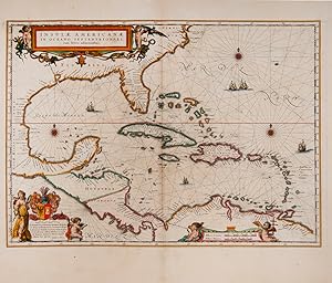
Insulae Americanae in Oceano Septentrionali cum Terris adiacentibus.
1637 Jansson Map of the Caribbean Sea and the Gulf Coast (Latin Appendix Edition)
- Mapa
Librería: Geographicus Rare Antique Maps, Brooklyn, NY, Estados Unidos de AmericaGeographicus Rare Antique Maps
Contactar con el vendedorVendedor de 4 estrellasCondición: Usado
EUR 2990,68
Envío por EUR 14,69Se envía dentro de Estados Unidos de AmericaCantidad disponible: 1 disponibles
Excellent. Fine original color with a bold strike. Few marginal spots. Plate number stamped in upper right, probably from a later composite binding. Size 15 x 20.5 Inches. This is a beautiful 1637 example of Jan Jansson's 1636 map of the Caribbean Islands and the adjacent coastlines of North and South America. It is among the mo…st beautiful maps of the region produced in the first half of the 17th century. Moreover, the present example is in superb condition with gorgeous, bright original color. A Closer Look Jansson's work here is derived from his competitor and neighbor, the Blaeu firm. The geography derives from their West Indische Paskaert and Hessel Gerritsz' unacquirable and authoritative 1631 De Eylanden Ende Vastelanden Van Westindien op de Noordzee . The map thus reflects those geographers' commanding knowledge of the Caribbean and the Gulf Coast. A Chartlike Map While Jansson's atlases were not intended for use at sea, his sources were Dutch West India nautical charts. The geographical detail reflects its sources in that the interiors of its landmasses are empty: nautical charts were not concerned with matters beyond the coastlines. The decorative features also emphasize the map's 'chartiness': the water areas feature rhumb lines, fine compass roses, and well-engraved sailing ships. Richly Decorative In addition to its nautical features, the map is embellished with two lovely cartouches. In the lower right, the scale cartouche is flanked with putti playing with navigational tools. In the upper left, the title cartouche's two putti are accompanied by snakes, a turtle, a bat, and an alarming number of iguanas. Publication History and Census This map was engraved by Jansson for inclusion in Jansson's 1636 Appendix Atlantis . It remained in print throughout the run of Jansson's atlases. The present example corresponds to the 1637 Latin Appendix edition noted in Van der Krogt. Separate examples of this map are well represented in institutional collections, and the map appears on the market from time to time in varied condition. Examples of this quality are nonetheless difficult to find. References: OCLC 18563810. Van der Krogt, P. C. J., Koeman's Atlantes Neerlandici, (Vol 1), 9600:1 Burden, P., The Mapping of North America, 248.w.
 Más imágenes
Carta do curso do rio Zaire : de Stanley-Pool au Oceano.
1883 Comissa?o Map of the Congo River: Capelo-Ivens Expedition
- Mapa
Librería: Geographicus Rare Antique Maps, Brooklyn, NY, Estados Unidos de AmericaGeographicus Rare Antique Maps
Contactar con el vendedorVendedor de 4 estrellasCondición: Usado
EUR 1993,78
Envío por EUR 14,69Se envía dentro de Estados Unidos de AmericaCantidad disponible: 1 disponibles
Good. Dissected and laid on linen. Some discoloration along fold lines, especially that separating the top third from the middle third. Size 25 x 44.5 Inches. This is a remarkable 1883 map of the Congo River and adjoining regions produced by the Portuguese Comissão de Cartografia das Colónias. It highlights knowledge gained from… the forgotten but important 1877 - 1879 Capelo-Ivens Expedition, a Portuguese effort to map and claim the lands along the river in the early days of the Scramble for Africa. A Closer Look Coverage extends from the West African coast as far north as Massabi and as far south as the mouth of the Congo River, near the present-day city of Soyo in Angola. Rivers, lakes, mountain ranges, roads, villages, local kingdoms, and ethnic groups are noted. Portuguese knowledge of coastal areas was clearly more advanced due to their centuries-long presence there, such as along the Chiloango (Cacongo) River starting from Landana. Certain areas of the interior, where missions ( missão ) were established or where Portuguese explorers, traders, and troops had long traveled, such as São Salvador (M'banza-Kongo) at bottom right, were also familiar to Lisbon, though not necessarily well-mapped. Much of the information at right was more detailed than in any earlier European maps. The stops ( estação ) made by Stanley during his travels through the region are indicated throughout. Explanatory notes provide critical information about features, particularly the hazards on the notoriously dangerous Congo River (waterfalls, whirlpools, and rapids). The recently-established city of Léopoldville (N'Tamo, Kinshana) is labeled at top-right, near the confluence of Stanley Pool (Pool Malebo) and the Congo River. Due to the hazards on the Congo River, the city remained isolated and remote until the completion of the Matadi-Kinshasa Railway (Chemin de Fer du Congo) in 1898. The Capelo-Ivens Expedition Though hardly as famous as Stanley and Livingstone, perhaps due to their nationality and subsequent relative weakness of the Portuguese Empire, Hermenegildo Capelo (here as Capello), Roberto Ivens, and Alexandre de Serpa Pinto were nearly as important for European exploration of the African interior. As discussed below, Portugal was anxious about the viability of its presence in Africa in the closing decades of the 19th century, and feared encroachments by the British and other European powers. At the same time, the advance of European military technology and the tactic of establishing protectorates with friendly local rulers provided opportunities to expand Portuguese control into the interior parts of the continent. Luciano Cordeiro, the founder of the Sociedade de Geografia de Lisboa, organized an expedition in 1877 with the aim of reaching the Kwango (Cuango) River, exploring areas to the south (near the present-day borders of Angola, Namibia, Zambia, Zimbabwe, and Botswana), and eventually traveling straight across the continent to the Boer Republics or Portuguese East Africa (Mozambique). More generally, the expedition aimed to find a reliable route between Angola and Mozambique to solidify Portugal's plans to create a Trans-African colony. The expedition, consisting of Capelo, Ivens, and Serpa Pinto, who later played an important role in the struggle with the British over the borders of Mozambique, quickly fell into disagreement and Serpa Pinto split off, exploring to the south around the Zambezi while Capelo and Ivens went north. After nearly three years of travel, the two men returned to Lisbon in March 1880, having charted the course of several rivers between the Congo and the Zambezi. They wrote about their expedition in the book De Benguela às Terras de Iaca ( From Benguela to the Lands of Iaca ). In the meantime, Serpa Pinto had reached Praetoria, completing the daunting task of crossing the continent, and also published a book, titled Como eu atravessei a África (translated as How I Crossed Africa ). In 1884 - 1885, Ca.

Carta General del Oceano Atlantico Septentrional que comprende desde el Ecuador hasta 55° 35' de latitud norte, y entre la longitud de 93° 45' al Oeste, y 17° al Este del meridiano de Cadiz.
1837 Direccion Hidrografia Nautical Chart / Map of the Atlantic Ocean
- Mapa
Librería: Geographicus Rare Antique Maps, Brooklyn, NY, Estados Unidos de AmericaGeographicus Rare Antique Maps
Contactar con el vendedorVendedor de 4 estrellasCondición: Usado
EUR 996,89
Envío por EUR 14,69Se envía dentro de Estados Unidos de AmericaCantidad disponible: 1 disponibles
Very good. Pencil marks recording c. 1867 trans-Atlantic voyage. Size 25 x 37.25 Inches. This is a rare 1837 / c. 1851 Direccion Hidrografía nautical chart or maritime map of the Atlantic Ocean with manuscript notations relating to an 1864 voyage from Cadiz to Havana. Coverage extends from Labrador and the North Sea to the Equat…or, and from the Gulf of Mexico to the Mediterranean. The chart offers meticulous coastal detail throughout, as well as interesting annotations regarding sighting of rocks, banks, and reefs sighted along the central route between Europe and America. Such charts were used for broad voyage planning and open sea, smaller more detailed charts were then used for approaches to land. The Voyage of the Andaluza Pencil marks trace the route of the February - March 1865 voyage of the Andaluza , a Covadonga class Screw Schooner in the Spanish Navy built specifically for the Cuba route - decommissioned in 1865. There appear to have been two ships that left Cadiz at the same time and voyaged mostly within sight of one another as far as the Virgin Islands. This 'caravanning' was a common maritime practice, as it offered ships the opportunity to support one another on the long passage, and additional defense against piracy. It is possible at this point that the ships parted ways, as afterwards, the track of only one ship is recorded as it makes its way to Havana, then between Florida and the Bahamas before setting out for open sea and Europe. Publication History and Census This large nautical chart was first published in 1837 by the Spanish Direccion Hidrografía. The map was drawn by José Espejo Y Carré and engraved in Madrid by Clemente Noguera, with lettering added by Manuel Giraldos. Although no further publication date appears on the map, we note updates to about 1851. Appears from time to time on the market.

Idioma: Alemán
- Primera edición
- Mapa
Librería: Antiquariat Clemens Paulusch GmbH, Berlin, , AlemaniaAntiquariat Clemens Paulusch GmbH
Contactar con el vendedorVendedor de 5 estrellasCondición: Usado
EUR 850,00
Envío por EUR 26,90Se envía de Alemania a Estados Unidos de AmericaCantidad disponible: 1 disponibles
1646, 47 x 36,5 (H) Norwich, Maps of Africa, 251. Seltene Seekarte aus der Erstausgabe des berühmten Seeatlas, noch ohne das in der 2. Ausgabe hinzugefügte 'Lo.6o' in der Kartusche. Zeigt den Atlantik nördlich von der Insel Corvo, die Phantominsel Mayda (hier "Maidas") im Zentrum. Mit Windrose und Segelschiff.

Idioma: Alemán
- Mapa
Librería: Antiquariat Clemens Paulusch GmbH, Berlin, , AlemaniaAntiquariat Clemens Paulusch GmbH
Contactar con el vendedorVendedor de 5 estrellasCondición: Usado
EUR 950,00
Envío por EUR 26,90Se envía de Alemania a Estados Unidos de AmericaCantidad disponible: 1 disponibles
mit altem Grenzkolorit, um 1682, 46 x 56 Burden, Mapping of North America Bd. 2, Nr. 531 (mit Abb. des 2. Zustandes). Mit zwei fig. Kartuschen. - Zeigt den Golf von Mexiko sowie die Karibische See mit den anliegeden Staaten. Kuba im Zentrum der Karte. Im Nordosten noch die Bermudas. Koloritbrüche im Bereich des Grün und einige E…inrisse restauriert. Zustand 2 von 4 (mit Privileg aber vor dem Kartenraster).
Idioma: Italiano
- Mapa
Librería: Anah Dunsheath RareBooks ABA ANZAAB ILAB, Auckland, NZ, Nueva ZelandaAnah Dunsheath RareBooks ABA ANZAAB ILAB
Contactar con el vendedorVendedor de 5 estrellasCondición: Usado - Bueno
EUR 488,17
Envío por EUR 21,60Se envía de Nueva Zelanda a Estados Unidos de AmericaCantidad disponible: 1 disponibles
Unbound. Condición: Very Good. Early, original hand-coloured engraved Italian map. Free-floating but protected by mylar. Full size 55 x 43 cm. A handsome early Italian map with slight water stain on RH lower corner not affecting the map image.


