
Importe total (1 artículo artículos):
Destino del pedido:

motorists index (10 resultados)
Ir a los resultados principales
Filtros de búsqueda
Tipo de artículo
- Todos los tipos de productos
- Libros (10)
- Revistas y publicaciones (No hay ningún otro resultado que coincida con este filtro.)
- Cómics (No hay ningún otro resultado que coincida con este filtro.)
- Partituras (No hay ningún otro resultado que coincida con este filtro.)
- Arte, grabados y pósters (No hay ningún otro resultado que coincida con este filtro.)
- Fotografías (No hay ningún otro resultado que coincida con este filtro.)
- Mapas (No hay ningún otro resultado que coincida con este filtro.)
- Manuscritos y coleccionismo de papel (No hay ningún otro resultado que coincida con este filtro.)
Condición Más información
- Nuevo (No hay ningún otro resultado que coincida con este filtro.)
- Como nuevo, Excelente o Muy bueno (2)
- Bueno o Aceptable (6)
- Regular o Pobre (2)
- Tal como se indica (No hay ningún otro resultado que coincida con este filtro.)
Encuadernación
Más atributos
- Primera edición (1)
- Firmado (No hay ningún otro resultado que coincida con este filtro.)
- Sobrecubierta (No hay ningún otro resultado que coincida con este filtro.)
- Con imágenes (7)
- No impresión bajo demanda (10)
Idioma (2)
Gastos de envío gratis
- Envío gratis a Estados Unidos de America (No hay ningún otro resultado que coincida con este filtro.)
Ubicación del vendedor
Valoración de los vendedores
-
Motorist's Atlas of Britain: Clear Road Maps at 4 Miles to 1 Inch - 98 Town Plans - Index to Over 30000 Places - London Street Plan
Idioma: Inglés
Publicado por John Bartholomew & Son Ltd, 1986
ISBN 10: 0702807524 ISBN 13: 9780702807527
Librería: Bookbot, Prague, Republica Checa
Calificación del vendedor: 5 de 5 estrellas

EUR 3,80
Envío por EUR 20,99
Se envía de Republica Checa a Estados Unidos de AmericaCantidad disponible: 1 disponibles
Ańadir al carritoHardcover. Condición: Fine. Leichte Rillen / Abschürfungen / Risse / Knicke; Gebrochener Buchrücken; Farbtonänderung.
-
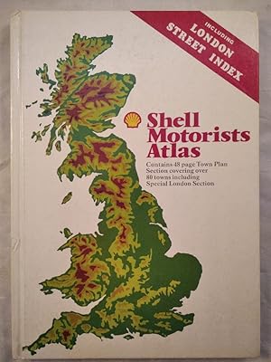
Shell Motorist's Atlas. Including London Street Index.
Librería: KULTur-Antiquariat, Boizenburg, MV, Alemania
Calificación del vendedor: 5 de 5 estrellas
EUR 19,80
Envío por EUR 17,00
Se envía de Alemania a Estados Unidos de AmericaCantidad disponible: 1 disponibles
Ańadir al carritoGebundene Ausgabe. Condición: Gut. 4. Auflage. 128 Seiten, zahlreich illustriert. Buch sehr gut erhalten, nur Einband ganz leicht berieben und leicht angeschmutzt. Ecken leicht bestoßen. Leichte Läsur am Rand des Buchrückens. Sprache: Englisch Gewicht in Gramm: 720.
-

The Paul Felix Warburg Union Catalog of Arbitration: A Selective Bibliography and Subject Index of Peaceful Dispute Settlement Procedures (Three Volume Set): Volume I-Alphabetical Index; Volume II-Subject Index (Commercial-International Commercial-International Public); Volume III-Subject Index (Labor-Community Disputes-Uninsured Motorists)
Publicado por Rowman and Littlefield, 1974
ISBN 10: 0874715237 ISBN 13: 9780874715231
Librería: GloryBe Books & Ephemera, LLC, Deforest, WI, Estados Unidos de America
Calificación del vendedor: 5 de 5 estrellas
EUR 31,01
Envío por EUR 4,81
Se envía dentro de Estados Unidos de AmericaCantidad disponible: 1 disponibles
Ańadir al carritoHardcover. Condición: Good. Pages slightly tanned otherwise Good Plus. NOT FORMER LIBRARY BOOKS Requires additional shipping due to size, weight, or multiple volumes.
-

Shell motorists index
Publicado por Shell Motor Company, New Zealand, 1930
Librería: Book Express (NZ), Shannon, Nueva Zelanda
Calificación del vendedor: 4 de 5 estrellas

EUR 14,04
Envío por EUR 26,67
Se envía de Nueva Zelanda a Estados Unidos de AmericaCantidad disponible: 1 disponibles
Ańadir al carritoPaperback. Condición: Good. 82 pages. 82 pages. published circa 1930 ?- small format- folding fault chart at rear t orn - motoring hints of the period.
-
Bacon's New Half-Inch Maps for Cyclists and Motorists: South Wales, with Index
Publicado por T. E. Smith, Aberdare, 1912
Librería: Rooke Books PBFA, Bath, Reino Unido
Miembro de asociación: PBFA
Calificación del vendedor: 5 de 5 estrellas
EUR 28,57
Envío por EUR 23,10
Se envía de Reino Unido a Estados Unidos de AmericaCantidad disponible: 1 disponibles
Ańadir al carritoCloth. Condición: Good. None Ilustrador. A pull-out map for cyclists and motorists for South Wales. From Bacon's series of new half-inch maps. With an alphabetical index to towns. A lovely work of cartography, by the American mapmaker, George Washington Bacon. A entrepreneur at heart, Bacon founded numerous business, though most of these failed. It wasn't until 1870 when he established his business G. W. Bacon & Co., that he saw great commercial success producing atlas and maps. In a beige cloth binding with decorated front board. Externally, a trifle rubbed. Internally, generally firmly bound. Pages are browned and age-toned. Good. book.
-

SHELL MOTORISTS ATLAS. INCLUDING LONDON STREET INDEX
Librería: LIBRERIA AZACAN, Valladolid, VA, Espańa
Calificación del vendedor: 5 de 5 estrellas
EUR 7,00
Envío por EUR 35,00
Se envía de Espańa a Estados Unidos de AmericaCantidad disponible: 1 disponibles
Ańadir al carritoCondición: Bueno. Edita: Publications divisionvof the Automobile Associatio for Shell UK Oil. London 1981. 4Ş edicón. 128 pp. 21X30,2 cm. Cartoné. Como nuevo. Contains 48 page Town Plan. Section covering over. 80 towns including. Special London Section. Espańol.
-

Shell Motorists' Index
Publicado por The Shell Company Of New Zealand
Librería: Renaissance Books, ANZAAB / ILAB, Dunedin, Nueva Zelanda
Miembro de asociación: ANZAAB ILAB
Calificación del vendedor: 5 de 5 estrellas
Original o primera edición
EUR 15,95
Envío por EUR 30,11
Se envía de Nueva Zelanda a Estados Unidos de AmericaCantidad disponible: 1 disponibles
Ańadir al carritoSoftcover. Condición: Poor. Estado de la sobrecubierta: No Dust Jacket. First Edition. Last leaf detached. Staples rusted. 3/4" chip at head of paper spine. ; 76 pages. Card wrappers. Page dimensions: 141mm x 75mm. Illustrated. ; 24mo 5" - 6" tall.
-
Motorists Index
Publicado por Shell, Australia
Librería: Serendipitous Ink, Rosewood, QLD, Australia
Calificación del vendedor: 5 de 5 estrellas
EUR 28,51
Envío por EUR 36,77
Se envía de Australia a Estados Unidos de AmericaCantidad disponible: 1 disponibles
Ańadir al carritoSoftcover. Condición: Poor. Estado de la sobrecubierta: No Dust Jacket. Book is in poor condition, front cover and 1 text free page at front and rear absent. 1930s. Size: 16mo (very small). 126 pages. Quantity Available: 1. Category: Automobiles & Vehicles; Pictures of this item not already displayed here available upon request. Inventory No: 8574.
-
Map of England and Wales, Showing Railways Roads And Distances with Index and A Route Guide with Useful Information for Motorists
Publicado por Chart Publishing Company, ca. 1920, 1920
Librería: Sutton Books, Norwich, VT, Estados Unidos de America
Miembro de asociación: IOBA
Calificación del vendedor: 4 de 5 estrellas
EUR 110,75
Envío por EUR 4,73
Se envía dentro de Estados Unidos de AmericaCantidad disponible: 1 disponibles
Ańadir al carritoHardcover. Condición: Fine. hbks in maroon cloth-backed slipcase with gilt titles containing 2 colored maps (North and South) each 40" x 25" 8 miles/inch linen-backed and in 18 sections to avoid wear together with ŇIndex and GuideÓ 32pp stapled all are virtually unused and in excellent condition, a beautiful set.
-
Map of England and Wales, showing Railways, roads with their numbers, mileage between towns etc., complete with booklet Index and Route Guide with Useful Information for Motorists
Publicado por The Chart Publishing Company, G. W. Bacon and Co, London, 1920
Librería: Polar Books, Llandudno, CONWY, Reino Unido
Calificación del vendedor: 5 de 5 estrellas
EUR 65,47
Envío por EUR 28,89
Se envía de Reino Unido a Estados Unidos de AmericaCantidad disponible: 1 disponibles
Ańadir al carritoMap. Condición: Good. Early Edition. Bacon's Map of England & Wales showing Railways, Roads and Distances. 2 coloured maps, dissected and laid on linen. 2 maps, 98cm x 60cm and 100cm x 70 cm approx. Scale: 8 miles to one inch. Inset map showing "Main Roads out of London", Scale 2 miles to 1 and a quarter inches. Copyright L4079. One set of covers is detached but easily repairable. The maps are in very nice condition. Slip case worn. The accompanying 64 page booklet is in very good condition. The Ministry of Transport is mentioned in the 'explanation' in the information in the booklet and this was formed after the first world war in 1919. Quantity Available: 1. Shipped Weight: Under 1 kilogram. Category: Geography & Maps; Pictures of this item not already displayed here available upon request. Inventory No: 3986.


