
Importe total (1 artículo artículos):
Destino del pedido:

modern complete atlas world (58 resultados)
Ir a los resultados principales
Filtros de búsqueda
Tipo de artículo
- Todos los tipos de productos
- Libros (58)
- Revistas y publicaciones (No hay ningún otro resultado que coincida con este filtro.)
- Cómics (No hay ningún otro resultado que coincida con este filtro.)
- Partituras (No hay ningún otro resultado que coincida con este filtro.)
- Arte, grabados y pósters (No hay ningún otro resultado que coincida con este filtro.)
- Fotografías (No hay ningún otro resultado que coincida con este filtro.)
- Mapas (No hay ningún otro resultado que coincida con este filtro.)
- Manuscritos y coleccionismo de papel (No hay ningún otro resultado que coincida con este filtro.)
Condición Más información
Encuadernación
Más atributos
- Primera edición (2)
- Firmado (No hay ningún otro resultado que coincida con este filtro.)
- Sobrecubierta (No hay ningún otro resultado que coincida con este filtro.)
- Con imágenes (29)
- No impresión bajo demanda (30)
Idioma (3)
Gastos de envío gratis
Ubicación del vendedor
Valoración de los vendedores
-

The World-wide Atlas of Modern Geography, Political and Physical, Containing One Hundred and Twenty-eight Plates and Complete Index [cartographic Mate (Paperback or Softback)
Idioma: Inglés
Publicado por Legare Street Press 9/10/2021, 2021
ISBN 10: 1015190596 ISBN 13: 9781015190597
Librería: BargainBookStores, Grand Rapids, MI, Estados Unidos de America
Calificación del vendedor: 5 de 5 estrellas

EUR 24,02
Gastos de envío gratis
Se envía dentro de Estados Unidos de AmericaCantidad disponible: 5 disponibles
Ańadir al carritoPaperback or Softback. Condición: New. The World-wide Atlas of Modern Geography, Political and Physical, Containing One Hundred and Twenty-eight Plates and Complete Index [cartographic Mate. Book.
-

Hammond advanced reference atlas;: A complete social studies atlas in four parts, showing the geographical setting of the modern, medieval and ancient world
Idioma: Inglés
Publicado por Hammond World Atlas Corporation, 1972
ISBN 10: 0843760109 ISBN 13: 9780843760101
Librería: My Dead Aunt's Books, Hyattsville, MD, Estados Unidos de America
Calificación del vendedor: 5 de 5 estrellas
EUR 13,46
Envío por EUR 4,79
Se envía dentro de Estados Unidos de AmericaCantidad disponible: 1 disponibles
Ańadir al carritoUnknown Binding. Condición: good. Estado de la sobrecubierta: None. Unmarked solidly bound atlas.
-

Complete Atlas of the World, 4th Edition: Classic Mapping for the Modern World (DK Reference Atlases)
Librería: World of Books (was SecondSale), Montgomery, IL, Estados Unidos de America
Calificación del vendedor: 5 de 5 estrellas
EUR 30,23
Gastos de envío gratis
Se envía dentro de Estados Unidos de AmericaCantidad disponible: 2 disponibles
Ańadir al carritoCondición: Good. Item in good condition. Textbooks may not include supplemental items i.e. CDs, access codes etc.
-
Complete Atlas of the World, 4th Edition: Classic Mapping for the Modern World
Librería: Books From California, Simi Valley, CA, Estados Unidos de America
Calificación del vendedor: 4 de 5 estrellas

EUR 25,76
Envío por EUR 4,35
Se envía dentro de Estados Unidos de AmericaCantidad disponible: 5 disponibles
Ańadir al carritoHardcover. Condición: Good. Remainder mark on page edges. Cover and edges may have some wear.
-

The World-wide Atlas of Modern Geography, Political and Physical, Containing One Hundred and Twenty-eight Plates and Complete Index [cartographic Mate
Librería: GreatBookPrices, Columbia, MD, Estados Unidos de America
Calificación del vendedor: 5 de 5 estrellas
EUR 21,64
Envío por EUR 2,30
Se envía dentro de Estados Unidos de AmericaCantidad disponible: Más de 20 disponibles
Ańadir al carritoCondición: New.
-
The World-wide Atlas of Modern Geography, Political and Physical, Containing One Hundred and Twenty-eight Plates and Complete Index [cartographic Mate
Librería: GreatBookPrices, Columbia, MD, Estados Unidos de America
Calificación del vendedor: 5 de 5 estrellas
EUR 23,25
Envío por EUR 2,30
Se envía dentro de Estados Unidos de AmericaCantidad disponible: Más de 20 disponibles
Ańadir al carritoCondición: As New. Unread book in perfect condition.
-
The World-wide Atlas of Modern Geography, Political and Physical, Containing One Hundred and Twenty-eight Plates and Complete Index [cartographic Mate
Idioma: Inglés
Publicado por Legare Street Press 2021-09, 2021
ISBN 10: 1015190596 ISBN 13: 9781015190597
Librería: Chiron Media, Wallingford, Reino Unido
Calificación del vendedor: 5 de 5 estrellas
EUR 20,04
Envío por EUR 17,86
Se envía de Reino Unido a Estados Unidos de AmericaCantidad disponible: 10 disponibles
Ańadir al carritoPF. Condición: New.
-

The Modern complete Atlas of the World
Idioma: Inglés
Publicado por The John C. Winston Company, 1932
Librería: Hockley Books, Palgrave, ON, Canada
Calificación del vendedor: 5 de 5 estrellas
EUR 22,44
Envío por EUR 14,81
Se envía de Canada a Estados Unidos de AmericaCantidad disponible: 1 disponibles
Ańadir al carritoHardcover. Condición: Fair. Book is red cloth with decorated cover. Some edge wear. Several spots on cover. Was possibly a schoolbook at one time.
-
The World-wide Atlas of Modern Geography, Political and Physical, Containing One Hundred and Twenty-eight Plates and Complete Index [cartographic Material]
Librería: Ria Christie Collections, Uxbridge, Reino Unido
Calificación del vendedor: 5 de 5 estrellas
EUR 24,72
Envío por EUR 13,81
Se envía de Reino Unido a Estados Unidos de AmericaCantidad disponible: Más de 20 disponibles
Ańadir al carritoCondición: New. In.
-
The World-wide Atlas of Modern Geography, Political and Physical, Containing One Hundred and Twenty-eight Plates and Complete Index [cartographic Mate
Librería: GreatBookPricesUK, Woodford Green, Reino Unido
Calificación del vendedor: 5 de 5 estrellas
EUR 22,98
Envío por EUR 17,30
Se envía de Reino Unido a Estados Unidos de AmericaCantidad disponible: Más de 20 disponibles
Ańadir al carritoCondición: New.
-
The World-wide Atlas of Modern Geography, Political and Physical, Containing One Hundred and Twenty-eight Plates and Complete Index [cartographic Mate
Librería: GreatBookPricesUK, Woodford Green, Reino Unido
Calificación del vendedor: 5 de 5 estrellas
EUR 26,30
Envío por EUR 17,30
Se envía de Reino Unido a Estados Unidos de AmericaCantidad disponible: Más de 20 disponibles
Ańadir al carritoCondición: As New. Unread book in perfect condition.
-
![Imagen de archivo de The World-wide Atlas of Modern Geography, Political and Physical, Containing One Hundred and Twenty-eight Plates and Complete Index [cartographic Material] a la venta por Ria Christie Collections](https://pictures.abebooks.com/isbn/9781013881305-es-300.jpg)
The World-wide Atlas of Modern Geography, Political and Physical, Containing One Hundred and Twenty-eight Plates and Complete Index [cartographic Material]
Librería: Ria Christie Collections, Uxbridge, Reino Unido
Calificación del vendedor: 5 de 5 estrellas
EUR 34,31
Envío por EUR 13,81
Se envía de Reino Unido a Estados Unidos de AmericaCantidad disponible: Más de 20 disponibles
Ańadir al carritoCondición: New. In.
-

Hammond's Advanced Reference Atlas. a Complete Social Studies Atlas in Four Parts, Showing the Geographical Setting of the Modern, Medieval and Ancient World
Publicado por C. S. Hammond, 1961
Librería: Bank of Books, Ventura, CA, Estados Unidos de America
Calificación del vendedor: 5 de 5 estrellas
EUR 31,42
Envío por EUR 3,70
Se envía dentro de Estados Unidos de AmericaCantidad disponible: 1 disponibles
Ańadir al carritoHardcover. Condición: Acceptable. Ex-school book. Outer spine repaired with tape. Edges of covers have started to fray. A book that has various signs of damaged but is complete. Heavily worn. We have 75,000 books to choose from -- Ship within 24 hours -- Satisfaction Guaranteed!
-

The World-wide Atlas of Modern Geography, Political and Physical, Containing One Hundred and Twenty-eight Plates and Complete Index [cartographic Mate
Idioma: Inglés
Publicado por Creative Media Partners, LLC Sep 2021, 2021
ISBN 10: 1015190596 ISBN 13: 9781015190597
Librería: AHA-BUCH GmbH, Einbeck, Alemania
Calificación del vendedor: 5 de 5 estrellas
EUR 35,96
Envío por EUR 61,84
Se envía de Alemania a Estados Unidos de AmericaCantidad disponible: 2 disponibles
Ańadir al carritoTaschenbuch. Condición: Neu. Neuware.
-
![Imagen del vendedor de The World-wide Atlas of Modern Geography, Political and Physical, Containing One Hundred and Twenty-eight Plates and Complete Index [cartographic Material] a la venta por AHA-BUCH GmbH](https://pictures.abebooks.com/inventory/md/md31909624241.jpg)
The World-wide Atlas of Modern Geography, Political and Physical, Containing One Hundred and Twenty-eight Plates and Complete Index [cartographic Material]
Idioma: Inglés
Publicado por Creative Media Partners, LLC Sep 2021, 2021
ISBN 10: 1013881303 ISBN 13: 9781013881305
Librería: AHA-BUCH GmbH, Einbeck, Alemania
Calificación del vendedor: 5 de 5 estrellas
EUR 50,29
Envío por EUR 62,70
Se envía de Alemania a Estados Unidos de AmericaCantidad disponible: 2 disponibles
Ańadir al carritoBuch. Condición: Neu. Neuware.
-
![Imagen del vendedor de The World-wide Atlas of Modern Geography, Political and Physical, Containing One Hundred and Twenty-eight Plates and Complete Index [cartographic Material] a la venta por moluna](https://pictures.abebooks.com/inventory/md/md32058577972.jpg)
The World-wide Atlas of Modern Geography, Political and Physical, Containing One Hundred and Twenty-eight Plates and Complete Index [cartographic Material]
Librería: moluna, Greven, Alemania
Calificación del vendedor: 5 de 5 estrellas
EUR 30,16
Envío por EUR 48,99
Se envía de Alemania a Estados Unidos de AmericaCantidad disponible: Más de 20 disponibles
Ańadir al carritoCondición: New.
-
Complete Atlas of the World, 4th Edition: Classic Mapping for the Modern World (DK Reference Atlases)
Librería: GoldBooks, Denver, CO, Estados Unidos de America
Calificación del vendedor: 5 de 5 estrellas
EUR 219,84
Envío por EUR 4,79
Se envía dentro de Estados Unidos de AmericaCantidad disponible: 1 disponibles
Ańadir al carritoHardcover. Condición: new. New Copy. Customer Service Guaranteed.
-
The World-wide Atlas of Modern Geography, Political and Physical containing One Hundred and Twenty- eight Plates and Complete Index with an introduction by J. Scott Keltie LL.D
Idioma: Inglés
Publicado por W. & A.K. Johnston, 1898
Librería: The Cornish Bookworm, CAMBORNE, CORNW, Reino Unido
Calificación del vendedor: 5 de 5 estrellas
EUR 213,79
Envío por EUR 23,75
Se envía de Reino Unido a Estados Unidos de AmericaCantidad disponible: 1 disponibles
Ańadir al carritoHardcover. Condición: Fair to good. A scarce original copy of this Victorian atlas of the world complete with maps in good condition though some age tanning. Inner hinges weak so some movement of text block within casing though some repair where cracked. Binding holding. Attractive brown decorated cloth boards with some wear mainly at head and tail of spine. Some newspaper cutting showing Second world war maps and batttle fronts loosely inserted between pages. Size - 313mm. x 252mm. (4to.). Pp.128 + index 88pp. Overseas postage may necessitate additional charge depending on destination.
-
![Imagen del vendedor de The World-wide Atlas of Modern Geography, Political and Physical, Containing One Hundred and Twenty-eight Plates and Complete Index [cartographic Material] a la venta por moluna](https://pictures.abebooks.com/inventory/md/md31786715254.jpg)
The World-wide Atlas of Modern Geography, Political and Physical, Containing One Hundred and Twenty-eight Plates and Complete Index [cartographic Material]
Librería: moluna, Greven, Alemania
Calificación del vendedor: 5 de 5 estrellas
EUR 40,52
Envío por EUR 48,99
Se envía de Alemania a Estados Unidos de AmericaCantidad disponible: Más de 20 disponibles
Ańadir al carritoCondición: New.
-
The World-wide Atlas of Modern Geography, Political and Physical, Containing One Hundred and Twenty-eight Plates and Complete Index [cartographic Material]
Idioma: Inglés
Publicado por LIGHTNING SOURCE UK LTD, 2021
ISBN 10: 1015190596 ISBN 13: 9781015190597
Librería: PBShop.store US, Wood Dale, IL, Estados Unidos de America
Calificación del vendedor: 5 de 5 estrellas
EUR 27,21
Gastos de envío gratis
Se envía dentro de Estados Unidos de AmericaCantidad disponible: Más de 20 disponibles
Ańadir al carritoPAP. Condición: New. New Book. Shipped from UK. THIS BOOK IS PRINTED ON DEMAND. Established seller since 2000.
-
The World-wide Atlas of Modern Geography; Political and Physical; Containing One Hundred and Twenty-eight Plates and Complete Index [cartographic Material]
Librería: Ria Christie Collections, Uxbridge, Reino Unido
Calificación del vendedor: 5 de 5 estrellas
EUR 23,12
Envío por EUR 13,81
Se envía de Reino Unido a Estados Unidos de AmericaCantidad disponible: Más de 20 disponibles
Ańadir al carritoCondición: New. PRINT ON DEMAND Book; New; Fast Shipping from the UK. No. book.
-
MONARCH STANDARD ATLAS OF THE COMMERCIAL, GEOGRAPHICAL AND HISTORICAL WORLD: With a Description of Every Known Land, Both Near and Remote, Ancient and Modern, Embracing Complete, Original and Authentic Maps
Publicado por Monarch, Chicago, 1906
Librería: RON RAMSWICK BOOKS, IOBA, CARLSBAD, CA, Estados Unidos de America
Miembro de asociación: IOBA
Calificación del vendedor: 5 de 5 estrellas
EUR 148,10
Envío por EUR 5,66
Se envía dentro de Estados Unidos de AmericaCantidad disponible: 1 disponibles
Ańadir al carritoHard Cover. Condición: Very Good. Bound in the original dark green pebbled cloth with gilt titled cover. Text edges red. Olive green floral design endpapers, color frontispiece illustrated with African Natives and American Indians. Superbly illustrated with more than 500 photographic reproductions and full-page color maps. Oversize folio volume measuring 12 by 16.5 inches. Firmly bound. Clean and tight with crisp text. No name, bookplate or other markings. These large volumes seldom appear in such nice condition. See photos. [Quite heavy, no Priority or International shipping on this item] Size: Elephant Folio - over 15" - 23" tall.
-
The World-wide Atlas of Modern Geography, Political and Physical, Containing One Hundred and Twenty-eight Plates and Complete Index [cartographic Material]
Idioma: Inglés
Publicado por LIGHTNING SOURCE UK LTD, 2021
ISBN 10: 1015190596 ISBN 13: 9781015190597
Librería: PBShop.store UK, Fairford, GLOS, Reino Unido
Calificación del vendedor: 5 de 5 estrellas
EUR 24,69
Envío por EUR 4,80
Se envía de Reino Unido a Estados Unidos de AmericaCantidad disponible: Más de 20 disponibles
Ańadir al carritoPAP. Condición: New. New Book. Delivered from our UK warehouse in 4 to 14 business days. THIS BOOK IS PRINTED ON DEMAND. Established seller since 2000.
-
Cram`s Modern Atlas . The new unrivaled . New Census Edition . Indexed ., Containing a complete series of maps of modern geography, exhibiting the World and its various political divisions .
Publicado por Publ. James R. Gray, Chicago 1902, 1902
Librería: Johann Peter Hebel Antiquariat, Lörrach, Alemania
Calificación del vendedor: 3 de 5 estrellas

EUR 150,00
Envío por EUR 25,00
Se envía de Alemania a Estados Unidos de AmericaCantidad disponible: 1 disponibles
Ańadir al carritoCover Title: The World indexed. orig. cloth binding 2° Folio title in embossed printing 772 pages S. with numerous maps, photos and illustrations s.a Weltatlas, mit ca. 1000 Abbildungen, Karten, Flaggen, Fotos und Zeichnungen binding rubbed and with seven small stains.
-
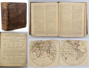
COMPLETE AND UNIVERSAL ENGLISH DICTIONARY, With Which is Incorporated a Complete Modern Gazetteer and Atlas of Maps. The Dictionary contains, 1. A Full Explanation of Difficult Words and Technical Terms in all Trades, Professions, Arts and Sciences, Algebra, Anatomy . Trigonometry . 2. A Pronoucing Dictionary, In Which the proper Sounds of English Words are so given, that both Natives and Foreigners may acquire a just Pronounciation. 3. Tracing the World from their original Fountains . The Geographical Part of this Work Is a modernized Compilation from Walker, Eachard, Salmon, Crutwell and other Authorities . Bought down to the end of the Year 1808, under the Editorship of a scientific and literary Character, comprehending all the changes in the Empires, Kingdoms .
Publicado por N.d. c., 1808
Librería: Francis Edwards ABA ILAB, Hay on Wye, Reino Unido
Miembro de asociación: ABA ILAB PBFA
Calificación del vendedor: 5 de 5 estrellas
EUR 235,17
Envío por EUR 21,91
Se envía de Reino Unido a Estados Unidos de AmericaCantidad disponible: 1 disponibles
Ańadir al carritoSm. 4to. viii + [13Q2] 18 maps and plans including 5 folding mainly hand coloured in outline (the world maps are cropped and detached with loss to Poles. Lacking all before t.p., 8G and 8G2 duplicated, t.p. cropped along head, browning, old leather, some wear, gilt lettered label to spine, US$267.
-
Cram's Modern Atlas of the World Containing A Complete Series of Maps from Modern Geography, Exhibiting the World and Its Various Political Divisions as They Are To-Day; A Carefully Prepared Description of Every State and Country
Publicado por George F. Cram, New York, 1908
Librería: Mullen Books, ABAA, Marietta, PA, Estados Unidos de America
Miembro de asociación: ABAA ILAB
Calificación del vendedor: 4 de 5 estrellas
EUR 314,15
Envío por EUR 11,32
Se envía dentro de Estados Unidos de AmericaCantidad disponible: 1 disponibles
Ańadir al carritoHardbound. Black cloth with brown leather spine and corners; silver lettering on cover; 774 pp. with color maps; Includes detailed maps of major U.S. cities and bw photographs of many locales. Text block intact; boards detached but present; leather spine missing; ding to bottom of text block and with some foxing to page edges.
-
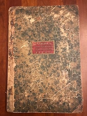
A New Genealogical, Historical, and Chronological Atlas; Being a Complete Guide to History, Both Ancient and Modern, Exhibiting an Accurate Account of the Origin, Descent, and Marriages of all the Royal Families, From the Beginning of the World to the Present Time
Publicado por J. Barfield, London, 1807
Librería: Jim Crotts Rare Books, LLC, Clemmons, NC, Estados Unidos de America
Calificación del vendedor: 2 de 5 estrellas

Original o primera edición
EUR 852,69
Envío por EUR 4,31
Se envía dentro de Estados Unidos de AmericaCantidad disponible: 1 disponibles
Ańadir al carritoA collection of atlas inspired maps that show the genealogical and history of the world, organized in hand-coloured easy to read plates. The first edition of this work. SCARCE. With thirty-five hand-coloured double paged plates. With a key containing an explanation of the marks and abbreviations used in the maps. Collated, bound without plate twenty-two (which appears to binder error). This work is called an atlas, whereas it only drew inspiration from an atlas. It consists of genealogical and chronological tables that document important phases in history, rather than maps. The work is an interesting approach to learning history, laying out the chronology and genealogical of the world in a series of flow diagrams and easy to follow descriptive text. It was intended to provide a more entertaining resource from which children and adults could learn about various aspects of global history. The discussions of the maps include 'Sacred History, from the Creation to the Passover', 'A Map of the Roman Empire, from Julius Caesar to Aurelianus', and 'The History of France, from Pharamond to Pepin'. Compiled by C. V. Lavoisne, who was a Professor at the University of Caen, and C. Gros, who was a Professor at the University of Paris. Lavoisne died before the completion of this work, and so it was continued by Gros. Bound in the original marbled paper boards, both of which are detached. Many of the folio pages are oddly folded. Rather poor condition in its present state, but an excellent candidate for professional repair and rebinding.
-
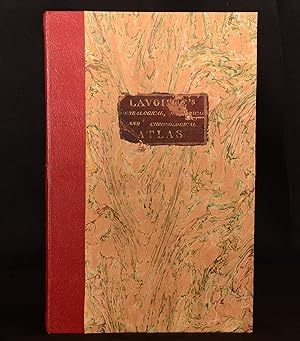
A New Genealogical, Historical, and Chronological Atlas; Being a Complete Guide to History, Both Ancient and Modern, Exhibiting an Accurate Account of the Origin, Descent, and Marriages of all the Royal Families, From the Beginning of the World to the Present Time
Publicado por J. Barfield, London, 1807
Librería: Rooke Books PBFA, Bath, Reino Unido
Miembro de asociación: PBFA
Calificación del vendedor: 5 de 5 estrellas
Original o primera edición
EUR 1.425,29
Envío por EUR 23,05
Se envía de Reino Unido a Estados Unidos de AmericaCantidad disponible: 1 disponibles
Ańadir al carritoLeather. Condición: Very Good. C. V. Lavoisne; C. Gros Ilustrador. First edition. A collection of atlas inspired maps that show the genealogical and history of the world, organised in hand-coloured easy to read plates. The first edition of this work. A scarce work. With thirty-five hand-coloured double paged plates. With a key containing an explanation of the marks and abbreviations used in the maps. Collated, bound without plate twenty-two. This work is called an atlas, whereas it only drew inspiration from an atlas. It consists of genealogical and chronological tables that document important phases in history, rather than maps. The work is an interesting approach to learning history, laying out the chronology and genealogical of the world in a series of flow diagrams and easy to follow descriptive text. It was intended to provide a more entertaining resource from which children and adults could learn about various aspects of global history. The discussions of the maps include 'Sacred History, from the Creation to the Passover', 'A Map of the Roman Empire, from Julius Caesar to Aurelianus', and 'The History of France, from Pharamond to Pepin'. Compiled by C. V. Lavoisne, who was a Professor at the University of Caen, and C. Gros, who was a Professor at the University of Paris. Lavoisne died before the completion of this work, and so it was continued by Gros. In a quarter morocco binding with marbled paper to the boards. Externally, smart. Original label to the front board with some loss and rubbing. Internally, firmly bound. Pages are bright and generally clean with the odd mark and handling mark. Plate 25 with some loss to the bottom and fore edge, resulting in loss of some text. Very Good. book.
-
[TRAVEL] [MAPS] A COMPLETE GENEALOGICAL, HISTORICAL, CHRONOLOGICAL, AND GEOGRAPHICAL ATLAS; BEING A GENERAL GUIDE TO HISTORY, BOTH ANCIENT AND MODERN: EXHIBITING AN ACCURATE ACCOUNT OF THE ORIGIN, DESCENT, AND MARRIAGES OF ALL THE ROYAL FAMILIES FROM THE BEGINNING OF THE WORLD: TOGETHER WITH THE VARIOUS POSSESSIONS, FOREIGN WARS, BATTLES OF RENOWN AND REMARKABLE EVENTS, TO THE BATTLE OF WATERLOO . THE WHOLE FORMING A COMPLETE SYSTEM OF HISTORY AND GEOGRAPHY
Publicado por M. Carey & Sons, Philadelphia, 1820
Librería: BLACK SWAN BOOKS, INC., ABAA, ILAB, Richmond, VA, Estados Unidos de America
Miembro de asociación: ABAA ESA ILAB
Calificación del vendedor: 5 de 5 estrellas
EUR 1.346,36
Envío por EUR 9,15
Se envía dentro de Estados Unidos de AmericaCantidad disponible: 1 disponibles
Ańadir al carritoHalf Leather. Condición: Very Good binding. First American Edition. The First American Edition of A Complete Genealogical, Historical, Chronological, and Geographical Atlas, executed by Matthew Carey in 1820. Complete with all maps and charts of 71 double-page plates -- including the important maps of the "United States of America" by John Melish, a 2-page maps showing Texas as a separate country and most of the Louisiana Purchase as Missouri Territory The copy with a hand made buckram cover, stitched to hold it in place, which has on it the signature of Thos. Picton, and the stamp of one Joseph Malcomsom Lurgan. Several of the maps have some dampstain, including the Melish map of the United States. The color throughout is strong and attractive. Very Good binding.
-
Lavoisne M., Atlas, anno 1820, with the Melish map A COMPLETE GENEALOGICAL, HISTORICAL, CHRONOLOGICAL, AND GEOGRAPHICAL ATLAS; BEING A GENERAL GUIDE TO HISTORY, BOTH ANCIENT AND MODERN: EXHIBITING AN ACCURATE ACCOUNT OF THE ORIGIN, DESCENT, AND MARRIAGES OF ALL THE ROYAL FAMILIES FROM THE BEGINNING OF THE WORLD: TOGETHER WITH THE VARIOUS POSSESSIONS, FOREIGN WARS, BATTLES OF RENOWN AND REMARKABLE EVENTS, TO THE BATTLE OF WATERLOO . THE WHOLE FORMING A COMPLETE SYSTEM OF HISTORY AND GEOGRAPHY M. Lavoisne Published by M. Carey & Sons, Philadelphia, 1820 The First American Edition of A Complete Genealogical, Historical, Chronological, and Geographical Atlas, executed by Matthew Carey in 1820. Complete with all maps and charts of 71 double-
Publicado por Philadelphia, 1820
Librería: Hammelburger Antiquariat, Hammelburg, Alemania
Calificación del vendedor: 5 de 5 estrellas
EUR 1.400,00
Envío por EUR 30,00
Se envía de Alemania a Estados Unidos de AmericaCantidad disponible: 1 disponibles
Ańadir al carritoHardcover. Condición: Ausreichend. Lavoisne M., Atlas, anno 1820, with the Melish map A COMPLETE GENEALOGICAL, HISTORICAL, CHRONOLOGICAL, AND GEOGRAPHICAL ATLAS; BEING A GENERAL GUIDE TO HISTORY, BOTH ANCIENT AND MODERN: EXHIBITING AN ACCURATE ACCOUNT OF THE ORIGIN, DESCENT, AND MARRIAGES OF ALL THE ROYAL FAMILIES FROM THE BEGINNING OF THE WORLD: TOGETHER WITH THE VARIOUS POSSESSIONS, FOREIGN WARS, BATTLES OF RENOWN AND REMARKABLE EVENTS, TO THE BATTLE OF WATERLOO . THE WHOLE FORMING A COMPLETE SYSTEM OF HISTORY AND GEOGRAPHY M. Lavoisne Published by M. Carey & Sons, Philadelphia, 1820 The First American Edition of A Complete Genealogical, Historical, Chronological, and Geographical Atlas, executed by Matthew Carey in 1820. Complete with all maps and charts of 71 double-page plates -- including the important maps of the "United States of America" by John Melish. Folio, some restorations. But the Melish map in good condition.


![Imagen del vendedor de [TRAVEL] [MAPS] A COMPLETE GENEALOGICAL, HISTORICAL, CHRONOLOGICAL, AND GEOGRAPHICAL ATLAS; BEING A GENERAL GUIDE TO HISTORY, BOTH ANCIENT AND MODERN: EXHIBITING AN ACCURATE ACCOUNT OF THE ORIGIN, DESCENT, AND MARRIAGES OF ALL THE ROYAL FAMILIES FROM THE BEGINNING OF THE WORLD: TOGETHER WITH THE VARIOUS POSSESSIONS, FOREIGN WARS, BATTLES OF RENOWN AND REMARKABLE EVENTS, TO THE BATTLE OF WATERLOO . THE WHOLE FORMING A COMPLETE SYSTEM OF HISTORY AND GEOGRAPHY a la venta por BLACK SWAN BOOKS, INC., ABAA, ILAB](https://pictures.abebooks.com/inventory/md/md30781522792.jpg)
