
Importe total (1 artículo artículos):
Destino del pedido:

mississippi color map (18 resultados)
Ir a los resultados principales
Filtros de búsqueda
Tipo de artículo
- Todos los tipos de productos
- Libros (7)
- Revistas y publicaciones (No hay ningún otro resultado que coincida con este filtro.)
- Cómics (No hay ningún otro resultado que coincida con este filtro.)
- Partituras (No hay ningún otro resultado que coincida con este filtro.)
- Arte, grabados y pósters (3)
- Fotografías (No hay ningún otro resultado que coincida con este filtro.)
- Mapas (6)
- Manuscritos y coleccionismo de papel (2)
Condición Más información
- Nuevo (No hay ningún otro resultado que coincida con este filtro.)
- Como nuevo, Excelente o Muy bueno (No hay ningún otro resultado que coincida con este filtro.)
- Bueno o Aceptable (18)
- Regular o Pobre (No hay ningún otro resultado que coincida con este filtro.)
- Tal como se indica (No hay ningún otro resultado que coincida con este filtro.)
Encuadernación
- Todas
- Tapa dura (No hay ningún otro resultado que coincida con este filtro.)
- Tapa blanda (No hay ningún otro resultado que coincida con este filtro.)
Más atributos
- Primera edición (No hay ningún otro resultado que coincida con este filtro.)
- Firmado (No hay ningún otro resultado que coincida con este filtro.)
- Sobrecubierta (No hay ningún otro resultado que coincida con este filtro.)
- Con imágenes (16)
- No impresión bajo demanda (18)
Idioma (2)
Gastos de envío gratis
Ubicación del vendedor
Valoración de los vendedores
-

Mississippi, Color Map
Idioma: Inglés
Publicado por C. S. Hammond & Company, Des Moines, 1962
Librería: Legacy Books II, Louisville, KY, Estados Unidos de America
Calificación del vendedor: 4 de 5 estrellas

EUR 6,25
Envío por EUR 5,06
Se envía dentro de Estados Unidos de AmericaCantidad disponible: 1 disponibles
Ańadir al carritoNo Binding. Condición: VG. Sized about 8 x 12 inches, clean and bright. Minnesota on verso.
-

Mississippi, Color Map
Idioma: Inglés
Publicado por J. W. Clement Co., Buffalo, 1937
Librería: Legacy Books II, Louisville, KY, Estados Unidos de America
Calificación del vendedor: 4 de 5 estrellas
EUR 6,25
Envío por EUR 5,06
Se envía dentro de Estados Unidos de AmericaCantidad disponible: 1 disponibles
Ańadir al carritoNo Binding. Condición: VG. Sized 10 x 14 inches, very clean and bright. Unrelated map on verso.
-

Popular Map of Mississippi, in Color
Idioma: Inglés
Publicado por Rand McNally & Company, Chicago
Librería: Legacy Books II, Louisville, KY, Estados Unidos de America
Calificación del vendedor: 4 de 5 estrellas
EUR 6,25
Envío por EUR 5,06
Se envía dentro de Estados Unidos de AmericaCantidad disponible: 1 disponibles
Ańadir al carritoNo Binding. Condición: VG. Circa 1937, sized about 11 x 14 inches, Minnesota map on verso.
-

Soil Map Of Mississippi, Wayne County, 1911, in color
Idioma: Inglés
Publicado por U.S. Department Of Agriculture, Washington, 1911
Librería: Legacy Books II, Louisville, KY, Estados Unidos de America
Calificación del vendedor: 4 de 5 estrellas
EUR 8,79
Envío por EUR 5,06
Se envía dentro de Estados Unidos de AmericaCantidad disponible: 1 disponibles
Ańadir al carritoNo Binding. Condición: Good. Bureau Of Soils, Field Operations, 1911, sized 34 x 34 inches, folding.
-
Soil Map Of Mississippi, Forrest County, 1911, in color
Idioma: Inglés
Publicado por U.S. Department Of Agriculture, Washington, 1911
Librería: Legacy Books II, Louisville, KY, Estados Unidos de America
Calificación del vendedor: 4 de 5 estrellas
EUR 8,79
Envío por EUR 5,06
Se envía dentro de Estados Unidos de AmericaCantidad disponible: 1 disponibles
Ańadir al carritoNo Binding. Condición: Good. Bureau Of Soils, Field Operations, 1911, sized 25.5 x 39 inches, folding.
-
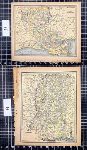
1887 Original Color Map: LOUISIANA / MISSISSIPPI
Publicado por Chicago : George F. Cram, 1887
Librería: CorgiPack, Fulton, NY, Estados Unidos de America
Calificación del vendedor: 4 de 5 estrellas
Mapa
EUR 14,20
Gastos de envío gratis
Se envía dentro de Estados Unidos de AmericaCantidad disponible: 1 disponibles
Ańadir al carritoMap. Condición: Very Good. Original color lithograph leaf from Cram's Atlas of the World. Please refer to photo for condition. PLEASE NOTE: If two images are shown they represent the obverse and reverse of the same leaf--not two separate leaves. Overall dimensions approx. 11.25" x 13.75. This item will be shipped flat.
-
State of Mississippi 1912 Rand McNally color Map with Railroads
Librería: The Jumping Frog, Hartford, CT, Estados Unidos de America
Calificación del vendedor: 2 de 5 estrellas

EUR 21,35
Envío por EUR 4,27
Se envía dentro de Estados Unidos de AmericaCantidad disponible: 1 disponibles
Ańadir al carritoNo binding. Condición: Very Good. Shipped in a tube. 30 x 20 1/2", vertical crease reinforced with linen as published. From a long-ago dismantled Library Atlas of the World: Rand McNally (1912). Maps may show earlier dates, but were updated for this edition. Dimensions given, if any, are approximate. Condition as shown. Defects not visible in scan[s] are described. Item is complete as issued unless otherwise stated. NO facsimiles, copies, reprints or reproductions unless specifically stated in description above. Pictures show actual item, never a stock image.
-
Mississippi & Alabama states together 1890 scarce folio Scribner-Black color map
Ańo de publicación: 1890
Librería: RareMapsandBooks, Dover, NH, Estados Unidos de America
Miembro de asociación: ESA IOBA
Calificación del vendedor: 4 de 5 estrellas
Mapa
EUR 25,81
Envío por EUR 6,01
Se envía dentro de Estados Unidos de AmericaCantidad disponible: 1 disponibles
Ańadir al carritoCondición: good. Mississippi - Albama.(Old Maps, 19th Century Maps, Americana, United States, Alabama, Montgomery, Mobile, Mississippi, Jackson). Issued 1890, NY by Scribner & Black. Scarce folio sheet late 19th century color lithographed map. A very uncommon oversized map from a monumental atlas which was a collaboration between the long running A & C Black and Scribner's of NY. This atlas had many supplemental maps unique to it not found in any other versions which precede it. Clean example, nice looking map. Sheet Measures c. 17 3/4" x 13" H. Printed Area Measures c. 16" x 11 1/4" H. Cartographic Reference (s):Tooley's Dictionary of Mapmakers, vol. 4.[R33922].
-
Mississippi Jackson Gulfport 1856 Morse Cerographic miniature hand color map
Ańo de publicación: 1856
Librería: RareMapsandBooks, Dover, NH, Estados Unidos de America
Miembro de asociación: ESA IOBA
Calificación del vendedor: 4 de 5 estrellas
Mapa
EUR 26,70
Envío por EUR 6,01
Se envía dentro de Estados Unidos de AmericaCantidad disponible: 1 disponibles
Ańadir al carritoCondición: good. Mississippi.(Old Maps, 19th Century Maps, North America, United States, American South, Mississippi, Jackson, Oxford, Gulfport, Biloxi, Tupelo). Issued 1856, New York by Morse & Gaston for Colby. Mid 19th century cerographic (wax engraved) map with original hand color. Nice looking example, pleasing age patina, any minor age flaws easy to overlook or forgive. Sheet Measures c. 6" H x 7 1/4" W. Printed Area Measures c. 5" H x 6 1/4" W. Cartographic Reference (s):Tooley's Dictionary of Mapmakers, vol. 3 pp 285. Ristow, American Maps & Mapmakers, pp. 154, 468 & 469.[B12327].
-
Mississippi huge state map 1888 uncommon oversize detailed folio sheet color map
Ańo de publicación: 1888
Librería: RareMapsandBooks, Dover, NH, Estados Unidos de America
Miembro de asociación: ESA IOBA
Calificación del vendedor: 4 de 5 estrellas
Mapa
EUR 26,70
Envío por EUR 6,01
Se envía dentro de Estados Unidos de AmericaCantidad disponible: 1 disponibles
Ańadir al carritoCondición: good. None.
-
MISSISSIPPI 1897 ANTIQUE COLOR MAP
Publicado por Century Maps
Librería: Artisans-lane Maps & Prints, Sidney, BC, Canada
Calificación del vendedor: 4 de 5 estrellas
Arte / Grabado / Póster
EUR 25,45
Envío por EUR 21,60
Se envía de Canada a Estados Unidos de AmericaCantidad disponible: 1 disponibles
Ańadir al carritono binding. Condición: very good. Close-up above showing lovely detail on the map. Copyright, 1897 Antique Political Map. - Published by Rand McNally & Co. for The Century Co. Engraved & printed in colours by W & A. K. Johnston, Edinburgh & London. Beautiful colored lines and borders. Showing counties, railroads, rivers, cities, towns. Mississippi's generally hilly landscape reaches its highest point (806 ft/246 m) in the northeastern corner of the state along the Tennessee River. The most distinctive region in the state's varied topography is the Mississippi Delta, a flat alluvial plain between the Mississippi and the Yazoo rivers in the western part of the state. A wide belt of longleaf yellow pine (the piney woods) covers most of southern Mississippi to within a few miles of the coastal-plain grasslands. Important there are lumbering and allied industries. Most of the state's rivers belong to either the Mississippi or the Alabama river systems, with the Pontoctoc Ridge the divide. The climate of Mississippi is subtropical in the southern part of the state and temperate in the northern part; the average annual rainfall is more than 50 in. (127 cm). The state, in the path of waterfowl migration routes down the Mississippi valley and home to many species of birds, is noted for its duck and quail hunting. Along the Gulf Coast, a favorite fishing area, are several resort cities and part of Gulf Islands National Seashore. Historical sites in Mississippi include Old Spanish Fort, the oldest house on the Mississippi River, near Pascagoula, as well as Vicksburg National Military Park, Brices Cross Roads National Battlefield Site, and Tupelo National Battlefield (see National Parks and Monuments , table). In Natchez and Biloxi are many fine antebellum mansions. Jackson is the capital and largest city. Other important cities are Biloxi, Greenville , Hattiesburg , and Meridian . . A look into the "Old World." A great item for the genealogy buff! Old maps can be a great help in tracing your family lineage. Some maps show important borders from a long time ago. Approximate Overall Size Including Margin: 11 1/2 X 16 inches The map is one large sheet with a centrefold and binders tape on reverse side to keep the map sturdy and intact. CONDITION: Suitable browning with a beautiful patina, appreciated from age & in Very Good Condition. Map image is crisp, clean, clear with excellent detail and in Excellent Condition. Blank on reverse side. Center Fold with binders tape at the reverse side to reinforce the fold. This beautiful print would look great matted and framed. An art supply store can provide you with a selection of frames for old art treasures. NOTE THE FOLLOWING BEFORE YOU PURCHASE: This is a GENUINE ANTIQUE MAP PRINT. It is NOT a modern reproduction, ie. a laser scan, photocopy etc. It is the original from the antique atlas or book publication. This map was published on the date mentioned, or circa of the date mentioned at the top of the page. The map print I have for sale, like many antique maps and prints that you see online, originate from an antique book or atlas publication. The publication may not always be known. If you have any questions, emails are welcome.
-
Historical 1897 Vintage Color Map of Mississippi
Publicado por Century Maps
Librería: Artisans-lane Maps & Prints, Sidney, BC, Canada
Calificación del vendedor: 4 de 5 estrellas
Arte / Grabado / Póster
EUR 25,45
Envío por EUR 21,60
Se envía de Canada a Estados Unidos de AmericaCantidad disponible: 1 disponibles
Ańadir al carritono binding. Condición: very good. Dated 1897 Antique Map - Beautiful Original Antique Color Map. There is about a half inch clear border around the map which does not show on the image above. Close-up below shows excellent color and lovely detail on the map. Engraved by THE MATTHEWS-NORTHRUP CO., BUFFALO, N. Y. Copyright, 1897 by the Century Co., New York (Date on Title area) Original Antique Map, not a modern reproduction. Originates from Century Co. Atlas. Approximate Overall Size Including Margin: 11 3/4 X 16 1/4 inches CONDITION: Excellent Condition. Suitable age-toning enhancing a beautiful patina, appreciated from age. Map image is clean, colors are crisp and detail is clear. Blank on reverse side and printed on medium weight paper. Centerfold with binders tape on reverse side only to reinforce the fold. Lovely Sunburst embellishment on the Title Piano Key border Miles and Kilometers scale Beautiful detailed antique map showing coloured lines of counties and borders.
-
Mississippi 1853 state map w/ fine hand color scarce
Ańo de publicación: 1853
Librería: RareMapsandBooks, Dover, NH, Estados Unidos de America
Miembro de asociación: ESA IOBA
Calificación del vendedor: 4 de 5 estrellas
Mapa
EUR 33,38
Envío por EUR 6,01
Se envía dentro de Estados Unidos de AmericaCantidad disponible: 1 disponibles
Ańadir al carritoCondición: good. Mississippi.(Old Maps, 19th Century Maps, Americana, United States, Midwest, Mississippi, Jackson, Vicksburg, Natchez). Issued 1853, New York for Phelps & Fanning. Original mid- 19th century wax engraved (cerographic) gazetteer map with lovely hand color. Text on reverse as always, the only way to own this map. A superior visual example. Pleasing age patina, any age flaws minor and easy to overlook or forgive. Sheet Measures c. 9 1/4" H x 5 1/2" W. Engraved Area Measures c. 8" H x 4 3/4" W.[R32361].
-
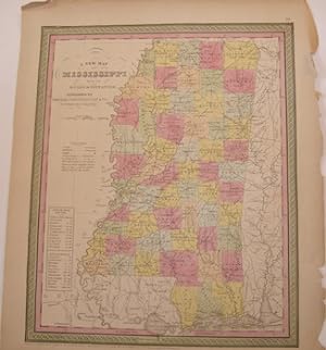
1888 Color Map of Mississippi
Publicado por Cram1888, 1888
Librería: Artisans-lane Maps & Prints, Sidney, BC, Canada
Calificación del vendedor: 4 de 5 estrellas
Arte / Grabado / Póster
EUR 31,81
Envío por EUR 21,60
Se envía de Canada a Estados Unidos de AmericaCantidad disponible: 1 disponibles
Ańadir al carritono binding. Condición: very good. Overall Size including text and borders : 11 1/4 x 13 1/2 ins. CONDITION: Single page Map that has a full page map on the back. As Scanned.This image shows a detailed 1888 map of the state of Mississippi. The map is color-coded to delineate different counties, with each county clearly labeled. The state's borders are well-defined, showing neighboring states such as Louisiana to the west, Alabama to the east, and Tennessee to the north. The Mississippi River forms the western border, its meandering path prominently illustrated. Major cities and towns are marked, and a network of railways crisscrosses the state, indicating the transportation infrastructure of the time. The Gulf Coast is visible at the southern edge of the map, featuring coastal islands and inlets. The map includes a scale in miles and appears to be part of a larger atlas, given its page number and framed presentation. The coloration is muted, typical of maps from this era, with pastel shades of pink, green, and yellow predominating. This historical document provides a comprehensive geographical and political view of Mississippi as it existed in the late 19th century, offering insights into the state's organization, development, and connectivity at that time. .NOTE THE FOLLOWING BEFORE YOU PURCHASE: This is a GENUINE ANTIQUE VINTAGE 1880s MAP. It is NOT a modern reproduction, ie. a laser scan, photocopy, etc. It is the original from the antique or vintage atlas or book publication. This map was published on the date mentioned, or circa the date mentioned at the top of the page. The map I have for sale, like many antique vintage prints and maps that you see online, originate from an antique vintage book or atlas publication. The publication may not always be known. If you have any questions, emails are welcome. Shipped Unmatted.
-

Geological Map Of Mississippi. Color Map.
Publicado por New York: J. H. Colton., 1855
Librería: Wittenborn Art Books, San Francisco, CA, Estados Unidos de America
Calificación del vendedor: 5 de 5 estrellas

Manuscrito
EUR 89,01
Envío por EUR 8,64
Se envía dentro de Estados Unidos de AmericaCantidad disponible: 1 disponibles
Ańadir al carritoCondición: Good. Printed Color Map. 14" x 17". Good with tears and minor losses along edges.
-
Louisiana Mississippi Arkansas Alabama New Orleans 1850 hand color engraved map
Ańo de publicación: 1850
Librería: RareMapsandBooks, Dover, NH, Estados Unidos de America
Miembro de asociación: ESA IOBA
Calificación del vendedor: 4 de 5 estrellas
Mapa
EUR 43,61
Envío por EUR 6,01
Se envía dentro de Estados Unidos de AmericaCantidad disponible: 1 disponibles
Ańadir al carritoCondición: good. Die Staaten von Arkansas, Mississippi, Louisiana, & Alabama.(Old Maps, 19th Century Maps, North America, United States, Louisiana, Mississippi, Alabama, Arkansas, New Orleans). Issued c. 1850, Hildburghausen, Germany by the Bibliographic Institute. Mid 19th century antique engraved map with original outline hand color. Well preserved, nice looking example with pleasing age patina, early ink note in top blank margin as seen. Sheet Measures c. 11 3/4" H x 9 3/4" W. Engraved Area Measures c. 9 3/4" H x 7 1/4" W. Cartographic Reference (s):Tooley's Dictionary of Mapmakers, vol. 1.[R33648].
-
1866 Color Steel Engraved Mitchell Map LOUISIANA Arkansas Mississippi Dixie CSA
Publicado por Philadelphia : S. Augustus Mitchell, 1866., 1866
Librería: Schilb Antiquarian, Columbia, MO, Estados Unidos de America
Calificación del vendedor: 5 de 5 estrellas
EUR 133,51
Gastos de envío gratis
Se envía dentro de Estados Unidos de AmericaCantidad disponible: 1 disponibles
Ańadir al carritoNo Binding. Condición: Very Good. 1866 Color Steel Engraved Mitchell Map LOUISIANA Arkansas Mississippi Dixie CSA Samuel Augustus Mitchell (1790 1868) was an American geographer. Map maker: Samuel Augustus Mitchell Title: "Map of Louisiana, Mississippi, and Arkansas." Atlas Title: Mitchell's New General Atlas containing maps of the various countries of the world, plans of cities, etc., embraced in fifty-eight quarto maps, forming a series of ninety-two maps and plans, together with valuable statistical tables. Published: Philadelphia : S. Augustus Mitchell, 1866. FREE SHIPPING WORLDWIDE Wear: wear as seen in photos Publisher: Philadelphia : S. Augustus Mitchell, 1866. Size: ~17.5in X 14in (44.5cm x 35.5cm) Photos available upon request.
-
A New Map Of Mississippi With Its Roads & Distances. Color Map.
Publicado por Philadelphia: Thomas Cowperthwait., 1850
Librería: Wittenborn Art Books, San Francisco, CA, Estados Unidos de America
Calificación del vendedor: 5 de 5 estrellas
Manuscrito
EUR 133,51
Envío por EUR 8,64
Se envía dentro de Estados Unidos de AmericaCantidad disponible: 1 disponibles
Ańadir al carritoCondición: Good. Printed Color Map. 13.5" x 17" Good with tears and minor losses along edges.


