Importe total (1 artículo artículos):
Destino del pedido:

marsdiep texel (21 resultados)
Ir a los resultados principales
Filtros de búsqueda
Tipo de artículo
- Todos los tipos de productos
- Libros (8)
- Revistas y publicaciones (No hay ningún otro resultado que coincida con este filtro.)
- Cómics (No hay ningún otro resultado que coincida con este filtro.)
- Partituras (No hay ningún otro resultado que coincida con este filtro.)
- Arte, grabados y pósters (No hay ningún otro resultado que coincida con este filtro.)
- Fotografías (No hay ningún otro resultado que coincida con este filtro.)
- Mapas (3)
- Manuscritos y coleccionismo de papel (10)
Condición Más información
- Nuevo (No hay ningún otro resultado que coincida con este filtro.)
- Como nuevo, Excelente o Muy bueno (1)
- Bueno o Aceptable (7)
- Regular o Pobre (No hay ningún otro resultado que coincida con este filtro.)
- Tal como se indica (13)
Encuadernación
- Todas
- Tapa dura (5)
- Tapa blanda (No hay ningún otro resultado que coincida con este filtro.)
Más atributos
- Primera edición (1)
- Firmado (No hay ningún otro resultado que coincida con este filtro.)
- Sobrecubierta (1)
- Con imágenes (15)
- No impresión bajo demanda (21)
Idioma (3)
Gastos de envío gratis
Ubicación del vendedor
Valoración de los vendedores
-
Ansichtskarte / Postkarte Texel Nordholland Niederlande, Diesel Electrische Veerboot Marsdiep, TESO
Librería: akpool.de - akpool GmbH, Berlin, Alemania
Calificación del vendedor: 4 de 5 estrellas

Manuscrito
EUR 6,00
Gastos de envío gratis
Se envía de Alemania a Estados Unidos de AmericaCantidad disponible: 1 disponibles
Añadir al carritoCondición: guter Zustand. Zustand, siehe Scan, ungelaufen - ca 14 cm X 9 cm.
-
Postkarte Carte Postale Fähre Marsdiep Texel
Librería: Versandhandel Boeger, Weil am Rhein, Alemania
Calificación del vendedor: 5 de 5 estrellas

Manuscrito
EUR 3,80
Envío por EUR 2,50
Se envía de Alemania a Estados Unidos de AmericaCantidad disponible: 1 disponibles
Añadir al carritoPostkarte Carte Postale Fähre Marsdiep Texel Marsdiep Texel Alte Ansichtskarte Postkarte.
-
Ansichtskarte / Postkarte Texel Nordholland, Fährschiff Marsdiep
Librería: akpool.de - akpool GmbH, Berlin, Alemania
Calificación del vendedor: 4 de 5 estrellas
Manuscrito
EUR 6,50
Gastos de envío gratis
Se envía de Alemania a Estados Unidos de AmericaCantidad disponible: 1 disponibles
Añadir al carritoCondición: guter Zustand. Zustand, siehe Scan, gelaufen - ca 14 cm X 9 cm.
-
Postkarte Carte Postale Texel Schapenboet Vuurtoren Strand Schapen Kampeerterrain Veerboot Marsdiep Badweg
Librería: Versandhandel Boeger, Weil am Rhein, Alemania
Calificación del vendedor: 5 de 5 estrellas
Manuscrito
EUR 4,30
Envío por EUR 2,50
Se envía de Alemania a Estados Unidos de AmericaCantidad disponible: 1 disponibles
Añadir al carritoCarte Postale Alte Postkarte Texel Schapenboet Vuurtoren Strand Schapen Kampeerterrain Veerboot Marsdiep Badweg postalisch gelaufen 1957 Erhaltung siehe scans [FriedD77] Frierer.
-
Postkarte Carte Postale Texel Marsdiep Nordseestrand Landschaft
Librería: Versandhandel Boeger, Weil am Rhein, Alemania
Calificación del vendedor: 5 de 5 estrellas
Manuscrito
EUR 4,30
Envío por EUR 2,50
Se envía de Alemania a Estados Unidos de AmericaCantidad disponible: 1 disponibles
Añadir al carritoCarte Postale Alte Postkarte Texel Marsdiep Nordseestrand Landschaft postalisch gelaufen 1921-1965 Erhaltung siehe scans Alte Ansichtskarte Postkarte MattID68.
-
Postkarte Carte Postale TEXEL Nordholland NL MS Marsdiep Bootshafen Windmuehle
Librería: Versandhandel Boeger, Weil am Rhein, Alemania
Calificación del vendedor: 5 de 5 estrellas
Manuscrito
EUR 5,00
Envío por EUR 2,50
Se envía de Alemania a Estados Unidos de AmericaCantidad disponible: 1 disponibles
Añadir al carrito -
Postkarte Carte Postale 72289755 Texel Hafen Windmuehle Schiff Marsdiep
Librería: Versandhandel Boeger, Weil am Rhein, Alemania
Calificación del vendedor: 5 de 5 estrellas
Manuscrito
EUR 5,90
Envío por EUR 2,50
Se envía de Alemania a Estados Unidos de AmericaCantidad disponible: 1 disponibles
Añadir al carrito -
Postkarte Carte Postale Texel Schapenboet Vuurtoren Strand Veerboot Marsdiep Kampeerterrein Weg
Librería: Versandhandel Boeger, Weil am Rhein, Alemania
Calificación del vendedor: 5 de 5 estrellas
Manuscrito
EUR 6,30
Envío por EUR 2,50
Se envía de Alemania a Estados Unidos de AmericaCantidad disponible: 1 disponibles
Añadir al carritoCarte Postale Alte Postkarte Texel Schapenboet Vuurtoren Strand Veerboot Marsdiep Kampeerterrein Weg postalisch gelaufen 1973 Alte Ansichtskarte Postkarte hz Fhwoer.
-

Met De Marsdiep Naar Texel 2x Ship Postcard
Librería: Postcard Finder, Norwich, Reino Unido
Calificación del vendedor: 4 de 5 estrellas
EUR 5,35
Envío por EUR 5,78
Se envía de Reino Unido a Estados Unidos de AmericaCantidad disponible: 1 disponibles
Añadir al carritouk126 Rare undated but circa 25 years ago origin postcards unused and mint.
-
Ansichtskarte / Postkarte Oudeschild Texel Nordholland Niederlande, Stoombootskoffiehuis, SS Marsdiep, Dokter Wagemaker
Año de publicación: 1939
Librería: akpool.de - akpool GmbH, Berlin, Alemania
Calificación del vendedor: 4 de 5 estrellas
Manuscrito
EUR 14,50
Gastos de envío gratis
Se envía de Alemania a Estados Unidos de AmericaCantidad disponible: 1 disponibles
Añadir al carritoCondición: guter Zustand. Zustand, siehe Scan, gelaufen, 1939 - ca 9 cm X 14 cm.
-

Muiterij aan het Marsdiep De tragedie van de Georgiërs op Texel april 1945
Publicado por Bataafsche Leeuw, Amsterdam, 1986
Librería: Bij tij en ontij ..., Kloosterburen, NL, Holanda
Calificación del vendedor: 4 de 5 estrellas
EUR 10,00
Envío por EUR 28,50
Se envía de Holanda a Estados Unidos de AmericaCantidad disponible: 1 disponibles
Añadir al carritoCloth binding, 29 cm, 95 pp. Ills.: zwart/wit illustraties. Cond.: goed / good. ISBN: 9067070874.
-

Muiterij aan het Marsdiep: De tragedie van de Georgie?rs op Texel, april 1945 (Dutch Edition)
Librería: Mooney's bookstore, Den Helder, Holanda
Calificación del vendedor: 4 de 5 estrellas
EUR 39,93
Envío por EUR 14,95
Se envía de Holanda a Estados Unidos de AmericaCantidad disponible: 1 disponibles
Añadir al carritoCondición: Very good.
-
Muiterij aan het Marsdiep. De tragedie van de Georgiërs op Texel, april 1945.
Idioma: Holandés
Publicado por De Bataafsche Leeuw, Amsterdam / Dieren, 1986
ISBN 10: 9067070874 ISBN 13: 9789067070874
Librería: Erwin Antiquariaat, Kampen, Holanda
Calificación del vendedor: 3 de 5 estrellas

Original o primera edición
EUR 45,00
Envío por EUR 27,00
Se envía de Holanda a Estados Unidos de AmericaCantidad disponible: 1 disponibles
Añadir al carritoCardboard / Karton. Condición: Good / Goed. Estado de la sobrecubierta: Good / Goed. 1ste / 1st. Boek en stofomslag in goede staat. 96 pagina's. Foto's, kaartjes, documenten. Size: A4.
-
Muiterij aan het Marsdiep. De tragedie van de Georgiërs op Texel, april 1945.
Librería: Rob Kok Old Books & Prints, Loosdrecht, NH, Holanda
Calificación del vendedor: 3 de 5 estrellas
EUR 15,00
Envío por EUR 26,00
Se envía de Holanda a Estados Unidos de AmericaCantidad disponible: 1 disponibles
Añadir al carritoAmst. & Dieren, De Btaafsche Leeuw, 1986. 96 blz. Met foto's. Gebonden met stofomslag. Fraai. #9067070874. [106286].
-
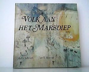
Volk aan het Marsdiep. Schetsen uit vier eeuwen Texel en Huisduinen - Den Helder.
Idioma: Holandés
Publicado por Uitgeverij Pirola Schoorl,, 1983
ISBN 10: 9064550301 ISBN 13: 9789064550300
Librería: Antiquariat Kirchheim, Lehrte, Alemania
Calificación del vendedor: 5 de 5 estrellas
EUR 38,00
Envío por EUR 80,00
Se envía de Alemania a Estados Unidos de AmericaCantidad disponible: 1 disponibles
Añadir al carritoCondición: Sehr gut. quer, 120 Seiten mit unzähligen Schwarz-weiß-Abbildungen, Karten und Faksimiles, farbig illustr. Orig.-Pappband, in niederländischer Sprache - Einband mit minimalen Gebrauchsspuren, sonst sehr guter Zustand - 1983. HM 4490 Buchversand erfolgt aus Deutschland. Sprache: Niederländisch Gewicht in Gramm: 520.
-
Muiterij aan het Marsdiep: De tragedie van de Georgie?rs op Texel, april 1945 (Dutch Edition)
Librería: Mooney's bookstore, Den Helder, Holanda
Calificación del vendedor: 4 de 5 estrellas
EUR 102,01
Envío por EUR 14,95
Se envía de Holanda a Estados Unidos de AmericaCantidad disponible: 1 disponibles
Añadir al carritoCondición: Very good.
-
Holland / Niederlande. Texel. 4 x Alte Ansichtskarte / Postkarte farbig, gel. ca 70 - 90ger Jahre. 3x Mehrbildkarten, 1x Met de Marsdiep Naar Texel.
Idioma: Alemán
Publicado por Div., 1970
Librería: ABC Versand e.K., Aarbergen, Alemania
Calificación del vendedor: 5 de 5 estrellas
Manuscrito
EUR 10,00
Envío por EUR 41,41
Se envía de Alemania a Estados Unidos de AmericaCantidad disponible: 1 disponibles
Añadir al carritoPostkarte. Condición: Gut. 4 x Alte Ansichtskarte / Postkarte farbig, Format ca 10,5 x 15 cm, kleinere Gebrauchsspuren an Ecken und Kanten, das Alter berücksichtigend in guter Erhaltung. AK10 Sprache: Deutsch Gewicht in Gramm: 202.
-
MUITERIJ AAN DE MARSDIEP de tragedie van de Georgiërs op Texel april 1945
Librería: Moby Dick, Noordwijk, Holanda
Calificación del vendedor: 4 de 5 estrellas
EUR 25,00
Envío por EUR 49,10
Se envía de Holanda a Estados Unidos de AmericaCantidad disponible: 1 disponibles
Añadir al carritoAmsterdam 1986.,96 pag., zwart-wit foto'; groot formaat stofomslag (code B-640).
-

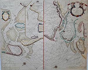
a. De Texel Stroom en de Gaten van Marsdiep. Inset (c. 24 x 12cm) : Caarte vande Rede en Haven van Medenblick hoemen die comen soo van 't Wieringer als Vriesch vlack beseylen mogen tot dienst en nut voor alle zeevaren luyden, perfectelyc gemete en afgepeylt. Beschreven A. 1659 uyt speciale last van E.H. Burgemeesteren en de Regeerders der voorss Stadt Medenblick. 43,2 x 26,7 cm b. Caerte van De Mase, Ende het Goereesche gat. (43,2 x 27 cm)
Publicado por Jacques & Gasper Anthoine, Amsterdam, 1662
Librería: Antiquariat Reinhold Berg eK Inh. R.Berg, Regensburg, Alemania
Miembro de asociación: ILAB VDA
Calificación del vendedor: 5 de 5 estrellas
Mapa
EUR 1.250,00
Envío por EUR 24,00
Se envía de Alemania a Estados Unidos de AmericaCantidad disponible: 1 disponibles
Añadir al carritoOther. Two sea-charts on one doublepage. The left one is showing Medenblick, Texel and Wieringen. Additional there is a small inset of Medenblick and Enckhuysen. On the other map the area of the river Maase with Rotterdam, Scheidam towards West Voeren is detailled shown. Both maps are ornated with title-cartouches and compass-roses. As well we find a milage scales to convert Dutch, English & French leagues to degrees. The maps are very accurately engraved, towns, harbour-places, sandbanks, depths are marked. A strong impression in overall good to very good condition, however there are two older very carefully mended tears or thin places in the paper of the 'Maase' map (in the blank sea between right of the lower centerfold and the compass-rose. 432 by 540mm (17 by 21¼ inches). 432 by 540mm (17 by 21¼ inches).
-
De Texel Stroom met de gaten van't Marsdiep. / Caarte van de Mase Ende het Goereesche gat.
Publicado por Hendrick Doncker, 1686
Librería: Antiquariaat Dat Narrenschip, Middelburg, Holanda
Miembro de asociación: ILAB NVVA
Calificación del vendedor: 5 de 5 estrellas
Mapa
EUR 600,00
Envío por EUR 27,00
Se envía de Holanda a Estados Unidos de AmericaCantidad disponible: 1 disponibles
Añadir al carritoNo Binding. Condición: Good. Twee zeekaarten op één blad: links van de Texelstroom en het Marsdiep met Texel, Den Helder, Wieringen. Met een inzetkaart van de haven en de rede van Medemblik en een deel van de kust rondom. Rechts een kaart van de Maasmonding met Rotterdam, Rozenburg, Voorne-Putten en de omgeving van Goedereede. Rugzijde blank. Handgekleurde kopergravure, uitgegeven in 1659 te Amsterdam door Hendrick Doncker in 'Le Grand & Nouveau Miroir ou Flambeau, De la Mer contenant la description de toutes les costes Marines Occidentalled & Septentrionalles (.).' Afmetingen (afbeelding): 43 x 53 cm.
-

Marsdiep, Texel - E
Librería: Inter-Antiquariaat Mefferdt & De Jonge, Amsterdam, Holanda
Miembro de asociación: ILAB NVVA
Calificación del vendedor: 4 de 5 estrellas
Mapa
EUR 1.650,00
Envío por EUR 42,00
Se envía de Holanda a Estados Unidos de AmericaCantidad disponible: 1 disponibles
Añadir al carrito19TH-CENTURY NAUTICAL CHART OF TEXEL AND THE MARSDIEP "Carte particulière des passes du Texel et de la Rade du Helder." Copper engraving on two joined sheets, made by E. Collin after Julius Constantijn Rijk. With an inset map "Plan du Drempel 1816" showing Fort Kijkduin, and an "Avertissement" with instructions on how to read the chart. Published in 1819 by the Dépôt général de la Marine. Coloured by a later hand. Size: 88.8 × 63.7 cm. Towards the end of the eighteenth century, responsibility for the content of Dutch sea charts shifted from private publishing houses and the VOC to officers of the Admiralties. The Netherlands lagged considerably behind England and France in carrying out state-supervised hydrographic surveys of coastal waters. Dutch surveys were far less reliable and complete than those produced by the French and the English. The first reliable chart of the Dutch sea inlets was due to the French naval officer Charles-François Beautemps Beaupré (17661854), who surveyed the waters of Zeeland and South Holland between 1799 and 1811. In 1812, Joan Cornelis van der Hoop (17421825), Advocate-Fiscal of the Admiralty of Amsterdam, commissioned naval lieutenant Julius Constantijn Rijk (17871854) and the pilot and hydrographer Pieter Jansen Duinker to survey the roadstead of Texel. This introduced a method of surveying that was new to the Netherlands. The cartographic work was exceptionally accurate owing to the use of an improved method of triangulation on land. The surveys by Rijk and Duinker were published in June 1816 as a printed chart of the Texel channel. Depth contours are shown using the 11-, 19-, and 28-foot lines below low water. These depth lines therefore indicate the depth of the fairway at low tide or ebb. It was the first chart in a series of sheets of the sea inlets, published between 1816 and 1840. With this chart, the Netherlands more than caught up with France and England. Indeed, the Dépôt général de la Marine in Paris copied the chart and in 1819 issued its own, comparable chart of the Marsdiep. Price: Euro 1.650,-.