

Importe total (1 artículo artículos):
Destino del pedido:

map profile supplement rivers lakes (1 resultados)
Ir a los resultados principales
Filtros de búsqueda
Tipo de artículo
- Todos los tipos de productos
- Libros (No hay ningún otro resultado que coincida con este filtro.)
- Revistas y publicaciones (No hay ningún otro resultado que coincida con este filtro.)
- Cómics (No hay ningún otro resultado que coincida con este filtro.)
- Partituras (No hay ningún otro resultado que coincida con este filtro.)
- Arte, grabados y pósters (No hay ningún otro resultado que coincida con este filtro.)
- Fotografías (No hay ningún otro resultado que coincida con este filtro.)
- Mapas (1)
- Manuscritos y coleccionismo de papel (No hay ningún otro resultado que coincida con este filtro.)
Condición Más información
- Nuevo (No hay ningún otro resultado que coincida con este filtro.)
- Como nuevo, Excelente o Muy bueno (No hay ningún otro resultado que coincida con este filtro.)
- Bueno o Aceptable (No hay ningún otro resultado que coincida con este filtro.)
- Regular o Pobre (No hay ningún otro resultado que coincida con este filtro.)
- Tal como se indica (1)
Encuadernación
- Todas
- Tapa dura (1)
- Tapa blanda (No hay ningún otro resultado que coincida con este filtro.)
Más atributos
- Primera edición (1)
- Firmado (No hay ningún otro resultado que coincida con este filtro.)
- Sobrecubierta (No hay ningún otro resultado que coincida con este filtro.)
- Con imágenes (1)
- No impresión bajo demanda (1)
Idioma (1)
Precio
- Cualquier precio
- Menos de EUR 20 (No hay ningún otro resultado que coincida con este filtro.)
- EUR 20 a EUR 45 (No hay ningún otro resultado que coincida con este filtro.)
- Más de EUR 45
Gastos de envío gratis
- Envío gratis a Estados Unidos de America (No hay ningún otro resultado que coincida con este filtro.)
Ubicación del vendedor
Valoración de los vendedores
-
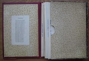
Map and Profile Supplement: Rivers & Lakes Commission Report -- Little Wabash and Skillet Fork Rivers
Publicado por [Illinois State Journal Company], [Springfield], 1911
Librería: Main Street Fine Books & Mss, ABAA, Galena, IL, Estados Unidos de America
Miembro de asociación: ABAA ILAB MWABA
Calificación del vendedor: 5 de 5 estrellas

Mapa Original o primera edición
EUR 66,35
Envío por EUR 5,15
Se envía dentro de Estados Unidos de AmericaCantidad disponible: 1 disponibles
Añadir al carritoHardcover. Small 4to. Burgundy cloth clamshell case with gilt spine lettering housing 23 large foldout maps (as issued). Floral pastedowns. Very good. Case slightly edgeworn and a bit rubbed, with mild cracking along outer edges (though expert archival inner lining maintains case shape and integrity); maps very good to near fine, with no separations evident. First edition of this scarce accompaniment to the "Report Upon the Prevention of Overflow of the Little Wabash and Skillet Fork Rivers," a 40pp study authored by W.J. McEathron, Leroy Lemayne Hidinger and others in 1911. The Little Wabash River is a 240-mile-long tributary of the Wabash River in southern Illinois and Skillet Fork a 98-mile-long tributary of the Little Wabash. Together they are part of the watershed of the Mississippi River. Lacks the 40-page clothbound report, but a superb and complete detailed map grouping.
